|
|
 |
|

|
|
|
Downscaling FY-3B soil moisture based on apparent thermal inertia and temperature vegetation index |
SONG Chengyun1( ), HU Guangcheng2, WANG Yanli1, TANG Chao1 ), HU Guangcheng2, WANG Yanli1, TANG Chao1 |
1. School of Geomatics, Anhui University of Science and Technology, Huainan 232001, China
2. State Key Laboratory of Remote Sensing Science, Aerospace Information Research Institute, Chinese Academy of Sciences, Beijing 100101, China |
|
|
|
|
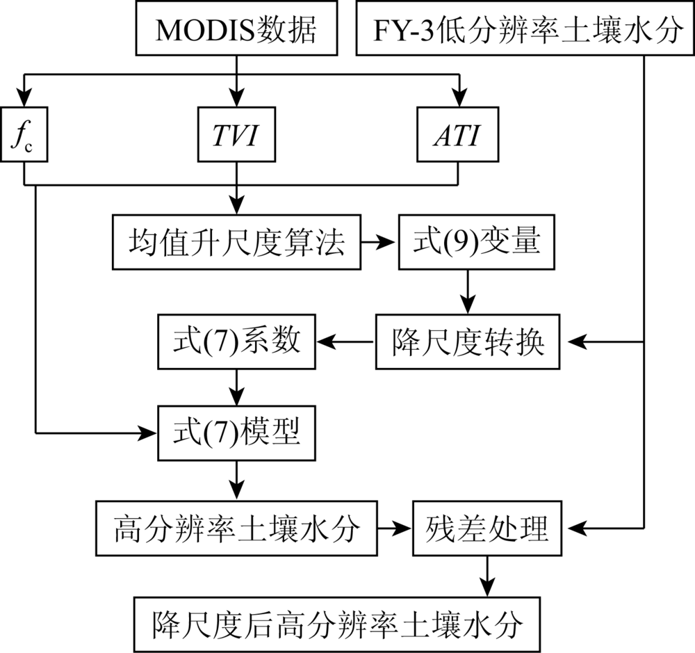
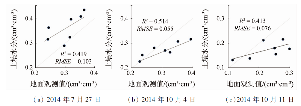
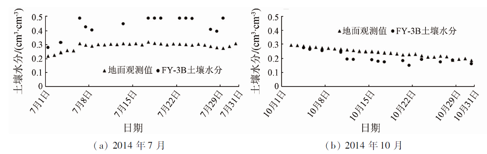
Abstract In order to further study the method of obtaining high-resolution soil moisture by downscaling FY-3B soil moisture and make it more suitable for agricultural and hydrological simulation, the authors constructed a comprehensive ATI and TVI by using MODIS data in Naqu area. Combined with low resolution FY-3B soil moisture products, the coefficients of soil moisture inversion model under high resolution were obtained by using soil moisture downscaling method, and the high-resolution soil moisture was obtained. Compared with the ground observation data, the R2 of the downscaling soil moisture and the measured data is above 0.4, and the RMSE is between 0.055 and 0.103 cm3/cm3, indicating that the downscaling soil moisture can better reflect the spatial distribution and change of soil moisture.
|
| Keywords
downscaling
FY-3B soil moisture
apparent thermal inertia
temperature vegetation index
|
|
|
|
Issue Date: 21 July 2021
|
|
|
| [1] |
Chen C F, Son N T, Chang L Y, et al. Monitoring of soil moisture variability in relation to rice cropping systems in the Vietnamese Mekong Delta using MODIS data[J]. Applied Geography, 2011, 31(2):463-475.
doi: 10.1016/j.apgeog.2010.10.002
url: https://linkinghub.elsevier.com/retrieve/pii/S0143622810001177
|
| [2] |
Njoku E G, Jackson T J, Lakshmi V, et al. Soil moisture retrieval from AMSR-E[J]. IEEE Transactions on Geoscience and Remote Sensing, 2003, 41(2):215-229.
doi: 10.1109/TGRS.2002.808243
url: http://ieeexplore.ieee.org/document/1196040/
|
| [3] |
Merlin O, Walker J P, Chehbouni A, et al. Towards deterministic downscaling of SMOS soil moisture using MODIS derived soil evaporative efficiency[J]. Remote Sensing of Environment, 2008, 112(10):3935-3946.
doi: 10.1016/j.rse.2008.06.012
url: https://linkinghub.elsevier.com/retrieve/pii/S0034425708002204
|
| [4] |
Narayan U, Lakshmi V, Njoku E G. Retrieval of soil moisture from passive and active L/S band sensor (PALS) observations during the Soil Moisture Experiment in 2002 (SMEX02)[J]. Remote Sensing of Environment, 2004, 92(4):483-496.
doi: 10.1016/j.rse.2004.05.018
url: https://linkinghub.elsevier.com/retrieve/pii/S0034425704001804
|
| [5] |
Zhao W, Li A. A comparison study on empirical microwave soil moisture downscaling methods based on the integration of microwave-optical/IR data on the Tibetan Plateau[J]. International Journal of Remote Sensing, 2015, 36(19-20):4986-5002.
doi: 10.1080/01431161.2015.1041178
url: https://www.tandfonline.com/doi/full/10.1080/01431161.2015.1041178
|
| [6] |
Chauhan N S, Miller S, Ardanuy P. Spaceborne soil moisture estimation at high resolution:A microwave-optical/IR synergistic approach[J]. International Journal of Remote Sensing, 2003, 24(22):4599-4622.
doi: 10.1080/0143116031000156837
url: https://www.tandfonline.com/doi/full/10.1080/0143116031000156837
|
| [7] |
Piles M, Camps A, Mercè V, et al. Downscaling SMOS-derived soil moisture using MODIS visible/infrared data[J]. IEEE Transactions on Geoence and Remote Sensing, 2011, 49:3156-3166.
|
| [8] |
曹永攀, 晋锐, 韩旭军, 等. 基于MODIS和AMSR-E遥感数据的土壤水分降尺度研究[J]. 遥感技术与应用, 2011, 26(5):590-597.
|
| [8] |
Cao Y P, Jin R, Han X J, et al. A downscaling method for AMSR-E soil moisture using MODIS derived dryness index[J]. Remote Sensing Technology and Application, 2011, 26(5):590-597.
|
| [9] |
孟祥金, 毛克彪, 孟飞, 等. 基于空间权重分解的降尺度土壤水分产品的中国土壤水分时空格局研究[J]. 高技术通讯, 2019, 29(4):104-114.
|
| [9] |
Meng X J, Mao K B, Meng F, et al. Temporal and spatial patterns of soil moisture in China based on spatial weight decomposition and downscaling soil moisture products[J]. High Technology Letters, 2019, 29(4):104-114.
|
| [10] |
Song C Y, Jia L. A method for downscaling FengYun-3B soil moisture based on apparent thermal inertia[J]. Remote Sensing, 2016, 8(9):1-16.
doi: 10.3390/rs8010001
url: http://www.mdpi.com/2072-4292/8/1/1
|
| [11] |
Kim S, Balakrishnan K, Liu Y, et al. Spatial disaggregation of coarse soil moisture data by using high-resolution remotely sensed vegetation products[J]. IEEE Geoence & Remote Sensing Letters, 2017, 14(9):1604-1608.
|
| [12] |
赵英时. 遥感应用分析原理与方法[M]. 北京: 科学出版社, 2003.
|
| [12] |
Zhao Y S. Analysis principle and method of remote sensing applications[M]. Beijing: Science Press, 2003.
|
| [13] |
王鹏新, 龚健雅, 李小文. 条件植被温度指数及其在干旱监测中的应用[J]. 武汉大学学报(信息科学版), 2001, 26(5):412-418.
|
| [13] |
Wang P X, Gong J Y, Li X W. Vegetation-temperature condition index and its application for drought monitoring[J]. Geomatics and Information Science of Wuhan University, 2001, 26(5):412-418.
|
| [14] |
Yang K, Qin J, Zhao L, et al. A multiscale soil moisture and freeze-thaw monitoring network on the Third Pole[J]. Bulletin of the American Meteorological Society, 2013, 94(12):1907-1916.
doi: 10.1175/BAMS-D-12-00203.1
url: http://journals.ametsoc.org/doi/10.1175/BAMS-D-12-00203.1
|
| [15] |
Shi J C, Jiang L M, Zhang L, et al. Physically based estimation of bare-surface soil moisture with the passive radiometers[J]. IEEE Transactions on Geoscience & Remote Sensing, 2006, 44:3145-3153.
|
| [16] |
Zhang N, Shi J, Sun G, et al. A simple algorithm for retrieval of the optical thickness at L-band from SMOS data[C]// IEEE International Geoscience & Remote Sensing Symposium.IEEE, 2012:198-210.
|
| [17] |
Price J C. On the analysis of thermal infrared imagery:The limited utility of apparent thermal inertia[J]. Remote Sensing of Environment, 1985, 18(1):59-73.
doi: 10.1016/0034-4257(85)90038-0
url: https://linkinghub.elsevier.com/retrieve/pii/0034425785900380
|
| [18] |
吴黎, 张有智, 解文欢, 等. 改进的表观热惯量法反演土壤含水量[J]. 国土资源遥感, 2013, 25(1):44-49.doi: 10.6046/gtzyyg.2013.01.08.
doi: 10.6046/gtzyyg.2013.01.08
|
| [18] |
Wu L, Zhang Y Z, Xie W H, et al. The inversion of soil water content by the improved apparent thermal inertia[J]. Remote Sensing for Land and Resources, 2013, 25(1):44-49.doi: 10.6046/gtzyyg.2013.01.08.
doi: 10.6046/gtzyyg.2013.01.08
|
| [19] |
魏伟, 任皓晨, 赵军, 等. 基于MODIS的ATI和TVI组合法反演石羊河流域土壤含水量[J]. 国土资源遥感, 2011, 23(2):104-109.doi: 10.6046/gtzyyg.2011.02.19.
doi: 10.6046/gtzyyg.2011.02.19
|
| [19] |
Wei W, Ren H C, Zhao J, et al. Retrieving soil moisture of shiyang river basin by ATI and TVI based on EOS /MODIS data[J]. Remote Sensing for Land and Resources, 2011, 23(2):104-109.doi: 10.6046/gtzyyg.2011.02.19.
doi: 10.6046/gtzyyg.2011.02.19
|
| [20] |
张文, 任燕, 马晓琳, 等. 基于综合干旱指数的淮河流域土壤含水量反演[J]. 国土资源遥感, 2018, 30(2):73-79.doi: 10.6046/gtzyyg.2018.02.10.
doi: 10.6046/gtzyyg.2018.02.10
|
| [20] |
Zhang W, Ren Y, Ma X L, et al. Estimation of soil moisture with drought indices in Huaihe river basin of east China[J]. Remote Sensing for Land and Resources, 2018, 30(2):73-79.doi: 10.6046/gtzyyg.2018.02.10.
doi: 10.6046/gtzyyg.2018.02.10
|
| [21] |
Carlson T N, Ripley D A. On the relation between NDVI,fractional vegetation cover,and leaf area index[J]. Remote Sensing of Environment, 1997, 62(3):241-252.
doi: 10.1016/S0034-4257(97)00104-1
url: https://linkinghub.elsevier.com/retrieve/pii/S0034425797001041
|
| [22] |
Cui Y, Chen X, Xiong W, et al. A soil moisture spatial and temporal resolution improving algorithm based on multi-source remote sensing data and GRNN model[J]. Remote Sensing, 2020, 12(45):1-13.
doi: 10.3390/rs12010001
url: https://www.mdpi.com/2072-4292/12/1/1
|
| [23] |
Zhang Y, Chen Y, Li J, et al. A simple method for converting 1-km resolution daily clear-sky LST into real LST[J]. Remote Sensing, 2020, 12(10):1-23.
doi: 10.3390/rs12010001
url: https://www.mdpi.com/2072-4292/12/1/1
|
|
Viewed |
|
|
|
Full text
|
|
|
|
|
Abstract
|
|
|
|
|
Cited |
|
|
|
|
| |
Shared |
|
|
|
|
| |
Discussed |
|
|
|
|
 2021,
Vol. 33
2021,
Vol. 33