|
|
|
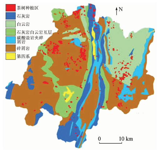
Abstract To investigate the geological background of Duyun tea planting, the authors studied the relationship between geological background and high quality Duyun tea planting efficiently and rapidly based on the theory of agricultural geology and using RS and GIS technology. Firstly, by using Sentinel-2A and Landsat8 remote sensing images and object-oriented classification method in combination with customized TEI and tea phenology information, high-precision extraction of tea planting areas was realized. Then, the spatial analysis function of GIS was used to count the distribution of various geological backgrounds in Duyun and the area of tea planting on different backgrounds accurately, and the geological background of tea planting in Duyun was investigated comprehensively. Lastly, the geochemical characteristics of rocks with different backgrounds were investigated by testing and analyzing the sampled data, and the planting map of suitable geological background area for tea planting in Duyun was compiled. The results show that the chemical elements in Duyun clastic rocks are obviously better than those in carbonate rocks. Clastic rocks are the advantageous geological background for tea planting and the important influencing factors for Duyun to produce high quality tea. The distribution area of clastic rocks accounts for 47.86% of the total area of Duyun, which means that clastic rocks possess the largest proportion of all lithologies, followed by dolomite, which accounts for 16.80%. 67.82% of Duyun tea is planted in clastic rock background, which is the basic condition for local tea production.
|
| Keywords
RS
GIS
Douyun tea
geological background
|
|
|
|
Corresponding Authors:
Rong CHEN
E-mail: 1304656630@qq.com
|
|
Issue Date: 14 March 2020
|
|
|
| [1] |
吴跃东, 向钒, 赵家厚 , 等. 黄山茶叶品质与产地地质背景关系探讨[J]. 资源调查与环境, 2010,31(1):39-49.
|
| [1] |
Wu Y D, Xiang F, Zhao J H , et al. Approach to relationship between Huangshan tea quality and geological background of growing areas[J]. Resources Survey and Environment, 2010,31(1):39-49.
|
| [2] |
任明强, 赵宾, 赵国宣 , 等. 贵州茶叶品质与地质环境的关系[J]. 贵州农业科学, 2011,39(2):30-33.
|
| [2] |
Ren M Q, Zhao B, Zhao G X , et al. Correlation between tea quality and geological environment in Guizhou[J]. Guizhou Agricultural Sciences, 2011,39(2):30-33.
|
| [3] |
韩晓彤, 毕坤, 杨瑞东 . 贵州地质背景与茶叶品质关系初探[J]. 贵州农业科学, 2010,38(4):72-76.
|
| [3] |
Han X T, Bi K, Yang R D . Preliminary discuss on relationship between geological background and tea quality in Guizhou[J]. Guizhou Agricultural Sciences, 2010,38(4):72-76.
|
| [4] |
彭益书, 陈蓉, 杨瑞东 , 等. 乌当区太子参环肽B含量及其与元素含量的相关性[J]. 西南农业学报, 2015,28(1):274-278.
|
| [4] |
Peng Y S, Chen R, Yang R D , et al. Correlation among heterophyllin B content in Pseudostellaria heterophylla,stratum and some trace elements content in Wudang District[J]. Southwest China Journal of Agricultural Sciences, 2015,28(1):274-278.
|
| [5] |
彭益书, 陈蓉, 杨瑞东 , 等. 贵阳市乌当区太子参及其种植土壤中14种元素含量与道地性[J]. 贵州农业科学, 2014,42(11):109-113.
|
| [5] |
Peng Y S, Chen R, Yang R D , et al. Genuineness of herbs and 14 elements contents in Pseudostellaria heterophylla and planting soil in Wudang District of Guiyang City[J]. Guizhou Agricultural Sciences, 2014,42(11):109-113.
|
| [6] |
Birke M, Reimann C, Rauch U , et al. GEMAS:Cadmium distribution and its sources in agricultural and grazing land soil of Europe—Original data versus clrtransformed data[J]. Journal of Geochemical Exploration, 2016,173:13-30.
|
| [7] |
Martin A P, Turnbull R E, Rattenbury M S , et al. The regional geochemical baseline soil survey of southern New Zealand:Design and initial interpretation[J]. Journal of Geochemical Exploration, 2016,167:70-82.
|
| [8] |
吴承龙, 程亮, 王成庭 , 等. 基于GIS的皖南山区茶叶种植适宜性评价[J]. 农业网络信息, 2012(2):27-32.
|
| [8] |
Wu C L, Cheng L, Wang C T , et al. Research on suitability evaluation of cultivated land for tea based on GIS in south[J]. Agriculture Network Information, 2012(2):27-32.
|
| [9] |
周旭, 安裕伦, 杨光斌 , 等. RS、GIS支持下都匀毛尖茶种植适宜地评价[J]. 贵州农业科学, 2005,33(5):10-14.
|
| [9] |
Zhou X, An Y L, Yang G B , et al. Evaluation on the suitable land of Duyun Maojian Tea planting based on RS and GIS[J]. Guizhou Agricultural Sciences, 2005,33(5):10-14.
|
| [10] |
宋星星, 毛艳玲, 邱龙霞 , 等. 基于GIS的长汀县茶园适宜性评价[J]. 江西农业大学学报, 2017,39(2):342-348.
|
| [10] |
Song X X, Mao Y L, Qiu L X , et al. GIS-based suitability evaluation of tea garden in Changting County[J]. Acta Agriculturae Universitatis Jiangxiensis, 2017,39(2):342-348.
|
| [11] |
尹娟, 王可耀 . 基于GIS的乐山市茶叶种植气候区划[J]. 现代农业科技, 2017(19):179-181.
|
| [11] |
Yin J, Wang K Y . Tea growing climatezoning in Leshan City based on GIS[J]. Modern Agricultural Science and Technology, 2017(19):179-181.
|
| [12] |
张森, 陈健飞, 龚建周 . 面向对象分类的决策树方法探讨——以Landsat-8 OLI为例[J]. 测绘科学, 2016,41(6):117-121.
|
| [12] |
Zhang S, Chen J F, Gong J Z . Object-oriented classification based on C5.0 algorithm[J]. Science of Surveying and Mapping, 2016,41(6):117-121.
|
| [13] |
苏腾飞 . 基于时间序列NDVI的河套平原农田分类方法[J]. 科技创新导报, 2014(25):202-203.
|
| [13] |
Su T F . Classification method of farmland in Hetao Plain based on time series NDVI[J]. Science and Technology Innovation Herald, 2014(25):202-203.
|
| [14] |
韩东升 . 基于决策树的乡村遥感影像分类算法[J]. 中国科技纵横, 2015(21):24-24.
|
| [14] |
Han D S . Rural remote sensing image classification based on decision tree[J]. China Science and Technology Panorama Magazine, 2015(21):24-24.
|
| [15] |
童成英, 何守阳, 丁虎 . 茶叶产地与品质的元素、同位素鉴别技术研究进展[J]. 生态学杂志, 2018,37(5):1574-1583.
|
| [15] |
Tong C Y, He S Y, Ding H . Research progress of element and isotope identification technology for the origin and quality of tea[J]. Chinese Journal of Ecology, 2018,37(5):1574-1583.
|
| [16] |
徐涵秋, 张博博, 关华德 , 等. 南方红壤区林下水土流失的遥感判别——以福建省长汀县为例[J]. 地理科学, 2017(8):147-153.
|
| [16] |
Xu H Q, Zhang B B, Guan H D , et al. Detection of soil erosion area under forest canopy in the red soil region of southern China using remote sensing techniques:Changting County,Fujian Province[J]. Scientia Geographica Sinica, 2017(8):147-153.
|
| [17] |
高琳, 龙怀玉, 刘鸣达 , 等. 农业地质背景与特色农作物品质相关性研究进展[J]. 土壤通报, 2011,42(5):1263-1267.
|
| [17] |
Gao L, Long H Y, Liu M D , et al. Review on the relationship between agro-geological background and crop quality[J]. Chinese Journal of Soil Science, 2011,42(5):1263-1267.
|
| [18] |
毕坤 . 论贵州茶叶品质与地质环境关系[J]. 贵州地质, 1997,14(2):105-120.
|
| [18] |
Bi K . On the relationship between tea quality and geological environments of Guizhou[J]. Guizhou Geology, 1997,14(2):105-120.
|
|
Viewed |
|
|
|
Full text
|
|
|
|
|
Abstract
|
|
|
|
|
Cited |
|
|
|
|
| |
Shared |
|
|
|
|
| |
Discussed |
|
|
|
|
 2020,
Vol. 32
2020,
Vol. 32
 ), Yufeng WU, Yueyue WANG