|
|
 |
|

|
|
|
A study of topographical differentiation of ecological land spatial-temporal pattern in Hebei Province |
| Aibin WU1,2, Yanxia ZHAO1, Yanjie QIN1, Huitao SHEN1, Qinchen LI1 |
1. Institute of Geographical Sciences Hebei Academy of Sciences/ Hebei Engineering Research Center for Geographic Information Application, Shijiazhaung 050011, China
2. Key Laboratory of Soil and Water Conservation and Desertification Control of Ministry of Education, College of Soil and Water Conservation,Beijimg Forestry University, Beijing 100083, China |
|
|
|
|
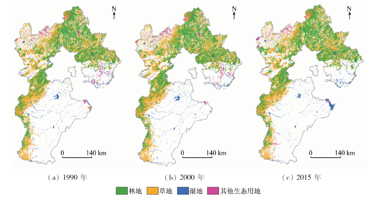
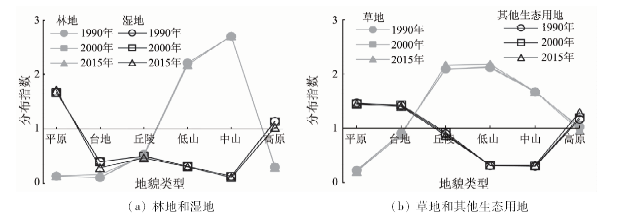
Abstract Ecological land is connected with human social development and natural ecological succession based on the inherent correlation between land use and land cover. Studying the topographical differentiation of ecological land spatial-temporal pattern in Hebei Province can provide scientific basis for the protection and optimization of ecological land in Beijing-Tianjin-Hebei region. Based on land use data of Hebei Province obtained in 1990, 2000 and 2015, the authors used GIS technology to analyze the topographical differentiation of ecological land spatial-temporal pattern in Hebei Province. The conclusions are as follows: ① The advantageous distribution topographical types of ecological land are hills, low mountain and middle mountain, while the advantageous distribution topographical types of forest are low mountain and middle mountain, the advantageous distribution topographical types of grassland are hills, low mountain and middle mountain, the advantageous distribution topographical types of wetland are plains and plateau, the advantageous distribution topographical types of other ecological land are plains, platform and plateau. ② During the study period, the forest in the platform and the other ecological land in plain, platform, low mountain and mid-mountain landform types had extremely poor spatial stability. ③ According to the land use change TUPU, the stable type is the primary land use change type, accounting for 86.75% of the whole catchment. The low mountain and middle mountain are the advantageous distribution topographical types for the stability, while the plain, platform, hill and plateau are the advantageous distribution topographical types for the prophase kind, the plain, platform and plateau are the advantageous distribution topographical types for the anaphase kind, the plain, platform and hill are the advantageous distribution topographical types for the repetitive kind, and the plain is the advantage distribution topographical type for the constant kind. The topographical differentiation of ecological land distribution, spatial stability and TUPU are significant.
|
| Keywords
ecological land
spatial-temporal pattern
topographical
Hebei
|
|
|
|
Issue Date: 18 June 2020
|
|
|
| [1] |
李炳元, 潘保田, 程维明, 等. 中国地貌区划新论[J]. 地理学报, 2013,68(3):292-302.
|
| [1] |
Li B Y, Pan B T, Cheng W N, et al. Research on geomorphological regionalization of China[J]. Acta Georaphica Sinica, 2013,68(3):292-302.
|
| [2] |
陈述彭. 地学的探索(第一卷)地理学[M]. 北京: 科学出版社, 1990.
|
| [2] |
Chen S P. Exploration in geo-science(the first volume) geography[M]. Beijing: Science Press, 1990.
|
| [3] |
包浩生. 江宁县横溪人民公社地貌类型及其土地利用[J].南京大学学报(自然科学版), 1963(15), 67-73.
|
| [3] |
Bao H S. Geomorphological types and land use of Hengxi People’s Commune in Jiangning County[J].Journal of Nanjing University(Natural Science), 1963(15):67-73.
|
| [4] |
王学志, 张正祥, 盛连喜, 等. 基于地貌特征的东北土地利用格局[J]. 生态学杂志, 2010,29(12):2444-2451.
|
| [4] |
Wang X Z, Zhang Z X, Sheng L X, et al. Land use patterns in Northeast China based on landform characteristics[J]. Chinese Journal of Ecology, 2010,29(12):2444-2451.
|
| [5] |
赵敏, 程维明, 黄坤, 等. 基于地貌类型单元的京津冀近10a土地覆被变化研究[J]. 自然资源学报, 2016,31(2):252-264.
|
| [5] |
Zhao M, Cheng W M, Huang Kun, et al. Research on land cover change in Beijing-Tianjin-Hebei region during the last 10 years based on different geomorphic units[J]. Journal of Natural Resources, 2016,31(2):252-264.
|
| [6] |
何维灿, 赵尚民, 程维明. 山西省不同地貌形态类型区土地覆被变化的GIS分析[J]. 地球信息科学学报, 2016,18(2):210-219.
|
| [6] |
He S W, Zhao S M, Cheng W M. Analysis of land cover change on basic geomorphic types in Shanxi Province[J]. Journal of Geo-information Science, 2016,18(2):210-219.
|
| [7] |
韩会庆, 杨广斌, 张凤太. 基于地貌特征的贵州省土地利用时空变化分析[J]. 南京林业大学学报(自然科学版), 2015,39(5):99-105.
|
| [7] |
Han H Q, Yang G B, Zhang F T. Spatio-temporal analysis of land use changes in Guizhou Province based on landform characteristics[J]. Journal of Nanjing Forestry University(Natural Sciences Edition), 2015,39(5):99-105.
|
| [8] |
潘方杰, 王宏志, 李仁东. 微地貌制约下江汉平原土地利用分异特征及变化方向[J]. 地域研究与开发, 2018,37(1):138-142.
|
| [8] |
Pan F J, Wang H Z, Li R D. Fractal characteristics and change direction of land use restricted by Micro-landform of the Jianghan Plain[J]. Aeral Research Development, 2018,37(1):138-142.
|
| [9] |
方炫, 曹建军, 那嘉明, 等. 黄土丘陵区土地利用变化的微地貌分异研究——以宁夏固原河川乡为例[J]. 地理与地理信息科学, 2017,33(4):113-118.
|
| [9] |
Fang X, Cao J J, Na J M, et al. Spatial patterns of land use changes in different micro-geomorphic types of loess hilly area:A case study of Hechuan town in Ningxia Hui Autonomous region[J]. Geography and Geo-Information Science, 2017,33(4):113-118.
|
| [10] |
蔡广鹏, 张朝琼. 岩溶山区不同地貌形态的土地利用变化比较分析[J]. 四川农业大学学报, 2015,33(4):392-398.
|
| [10] |
Cai G P, Zhang C Q. Temporal and spatial analysis of land use changes based on the topography[J]. Journal of Sichuan Agricultural University, 2015,33(4):392-398.
|
| [11] |
薛振山, 苏奋振, 杨晓梅, 等. 珠江口海岸带地貌特征对土地利用动态变化影响[J]. 热带地理, 2012,32(4):409-415.
|
| [11] |
Xue Z S, Su F Z, Yang X M, et al. Dynamic change of land use in coastal zone of the pearl river estuary-with landform analysis[J]. Tropical Geography, 2012,32(4):409-415.
url: http://www.rddl.com.cn/CN/abstract/abstract1392.shtml
|
| [12] |
汪小钦, 王钦敏, 励惠国, 等. 黄河三角洲土地利用/覆盖变化的微地貌区域分异[J]. 地理科学, 2008,28(4):513-517.
|
| [12] |
Wang X Q, Wang Q Q, Li H G, et al. Spatial pattern of LUCC in different micro-geomorphic types of Huanghe Kiver Delta[J]. Scientia Geographic Sintica, 2008,28(4):513-517.
|
| [13] |
邓红兵, 陈春娣, 刘昕, 等. 区域生态用地的概念及分类[J]. 生态学报, 2009,29(3):1519-1524.
|
| [13] |
Deng H B, Chen C D, Liu X, et al. Conception and function classification of regional ecological land[J]. Acta Ecologica Sinica, 2009,29(3):1519-1524.
|
| [14] |
喻锋, 李晓波, 张君, 等. 中国生态用地研究:内涵、分类与时空格局[J]. 生态学报, 2015,35(14):4931-4943.
|
| [14] |
Yu F, Li X B, Zhang J, et al. Study of ecological land in Cliina:Conception,classification,and spatial-temporal pattern[J]. Acta Ecologica Sinica, 2015,35(14):4931-4943.
|
| [15] |
周锐, 工新军, 苏海龙, 等. 平顶山新区生态用地的识别与安全格局构建[J]. 生态学报, 2015,35(6):2003-2012.
|
| [15] |
Zhou R, Gong X J, Su H L, et al. Identification and security pattern of ecological land in Pingdingslian newly developed area[J]. Acta Ecologica Sinica, 2015,35(6):2003-2012.
|
| [16] |
彭建, 汪安, 刘众序, 等. 城市生态用地需求测算研究进展与展望[J]. 地理学报, 2015,70(2):333-346.
|
| [16] |
Peng J, Wang A, Liu Z X, et al. Research progress and prospect on measuring urban ecological land demand[J]. Acta Georaphica Sinica, 2015,70(2):333-346.
|
| [17] |
周锐, 胡远满, 王新军, 等. 快速城镇化地区生态用地演变及驱动力分析[J]. 长江流域资源与环境, 2015,24(6):1012-1020.
|
| [17] |
Zhou R, Hu Y M, Wang X J, et al. Change characteristics of ecological land and its driving factors in rapidly urbanizing region[J]. Resources and Environment in the Yangtze Basin, 2015,24(6):1012-1020.
|
| [18] |
程迎轩, 王红梅, 刘光盛, 等. 基于最小累计阻力模型的生态用地空间布局优化[J]. 农业工程学报, 2016,32(16):248-257.
url: http://www.tcsae.org/nygcxb/ch/reader/view_abstract.aspx?file_no=20161634&flag=1
|
| [18] |
Cheng Y X, Wang H M, Liu G S, et al. Spatial layout optimization for ecological land based on minimum cumulative resistance model[J]. Transactions of the Chinese Society of Agricultural Engineering, 2016,32(16):248-257.
url: http://www.tcsae.org/nygcxb/ch/reader/view_abstract.aspx?file_no=20161634&flag=1
|
| [19] |
张鸯, 高松峰, 高成全, 等. 近20年平顶山市生态用地及其生态系统服务演变[J]. 生态科学, 2018,37(3):159-168.
|
| [19] |
Zhang Qian, Gao S F, Gao C Q, et al. Ecological land of Pingdingshan city and its ecosystem services evolution over the past 20 years[J]. Ecological Science, 2018,37(3):159-168.
|
| [20] |
武爱彬, 赵艳霞. 坝上高原生态用地时空格局演变与生态系统服务价值分析[J]. 农业工程学报, 2017,33(2):283-290.
|
| [20] |
Wu A B, Zhao Y X. Analysis of ecological land pattern evolution and ecosystem service value in Bashang plateau[J]. Transactions of the Chinese Society of Agricultural Engineering, 2017,33(2):283-290.
|
| [21] |
刘纪远, 匡文慧, 张增祥, 等. 20世纪80年代末以来中国土地利用变化的基本特征与空间格局[J]. 地理学报, 2014,69(1):3-14.
|
| [21] |
Liu J Y, Kuang W H, Zhang Z X, et al. Spatiao temporal characteristics, patterns and causes of land-use changes in China since the late 1980s[J]. Journal of Geographical Sciences, 2014,69(1):3-14.
|
| [22] |
喻红, 曾辉, 江子瀛. 快速城市化地区景观组分在地形梯度上的分布特征研究[J]. 地理科学, 2001,21(1):64-69.
|
| [22] |
Yu H, Zeng H, Jiang Z Y. Study on distribution characteristics of landscape elements along the terrain gradient[J]. Scientia Geographica Sinica, 2001,21(1):64-69.
|
| [23] |
龚文峰, 孔达, 范文义, 等. 松花江流域哈尔滨段土地利用时空格局演变特征分析[J]. 农业工程学报, 2009,25(8):249-255.
|
| [23] |
Gong W F, Kong D, Fan W Y, et al. Characteristic analysis of spatio-temporal pattern evolution of land use in Harbin region of Songhuajiang watershed[J]. Transactions of the Chinese Society of Agricultural Engineering, 2009,25(8):249-255.
|
| [24] |
张国坤, 邓伟, 张洪岩, 等新开河流域土地利用格局变化图谱分析[J]. 地理学报, 2010,65(9):1111-1120.
|
| [24] |
Zhang G K, Deng W, Zhang H Y, et al. The TUPU analysis of land use pattern in Xinkai river basin[J]. Acta Geographica Sinica, 2010,65(9):1111-1120.
|
| [25] |
孙丕苓, 许月卿, 王数. 环京津贫困带土地利用变化的地形梯度效应分析[J]. 农业工程学报, 2014,30(14):277-288.
url: http://www.tcsae.org/nygcxb/ch/reader/view_abstract.aspx?file_no=20141435&flag=1
|
| [25] |
Sun P L, Xu Y Q, Wang S. Terrain gradient effect analysis of land use change in poverty area around Beijing and Tianjin[J]. Transactions of the Chinese Society of Agricultural Engineering, 2014,30(14):277-288.
|
| [26] |
张静, 任志远. 秦巴山区土地利用时空格局及地形梯度效应[J]. 农业工程学报, 2016,32(14):250-257.
|
| [26] |
Zhang J, Ren Z Y. Spatio temporal pattern and terrain gradient effect of land use change in Qinling-Bashan mountains[J]. Transactions of the Chinese Society of Agricultural Engineering, 2016,32(14):250-257.
|
| [27] |
李京京, 吕哲敏, 石小平, 等. 基于地形梯度的汾河流域土地利用时空变化分析[J]. 农业工程学报, 2016,32(7):230-236.
|
| [27] |
Li J J, Li Z M, Shi X P, et al. Spatiotemporal variations analysis for land use in Fen River Basin based on terrain gradient[J]. Transactions of the Chinese Society of Agricultural Engineering, 2016,32(7):230-236.
|
| [28] |
贾宝全, 王成, 马玉峰. 赤峰市松山区土地利用动态变化及其原因分析[J]. 干旱区研究, 2004,21(3):235-239.
|
| [28] |
Jia B Q, Wang C, Ma Y F. Analysis on land use change and its driving factors in Songshan district,Chifeng City,Inner Mongolia[J]. Arid Zone Research, 2004,21(3):235-239.
|
|
Viewed |
|
|
|
Full text
|
|
|
|
|
Abstract
|
|
|
|
|
Cited |
|
|
|
|
| |
Shared |
|
|
|
|
| |
Discussed |
|
|
|
|
 2020,
Vol. 32
2020,
Vol. 32