|
|
 |
|

|
|
|
A study of the livability of urban environment based on multi-source remote sensing data: A case study of Beijing City |
DONG Jiaji1( ), REN Huazhong1,2(), ZHENG Yitong1, NIE Jing1, MENG Jinjie1, QIN Qiming1,2 ), REN Huazhong1,2(), ZHENG Yitong1, NIE Jing1, MENG Jinjie1, QIN Qiming1,2 |
1. Institute of Remote Sensing and Geographic Information System, School of Earth and Space Sciences,Peking University, Beijing 100871, China
2. Beijing Key Laboratory of Spatial Information Integration and Its Application, Peking University, Beijing 100871, China |
|
|
|
|
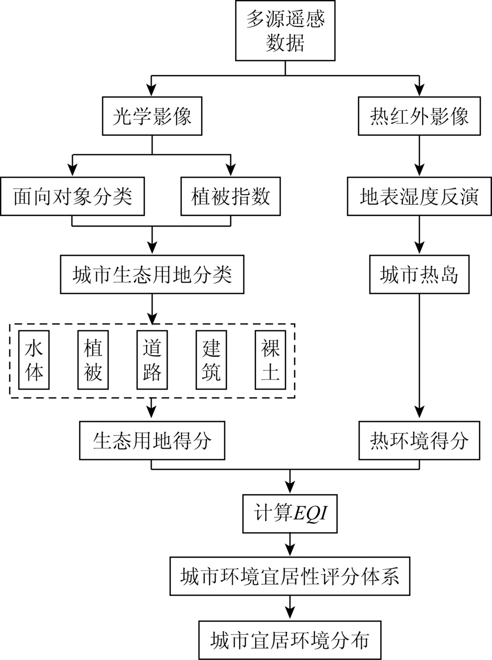
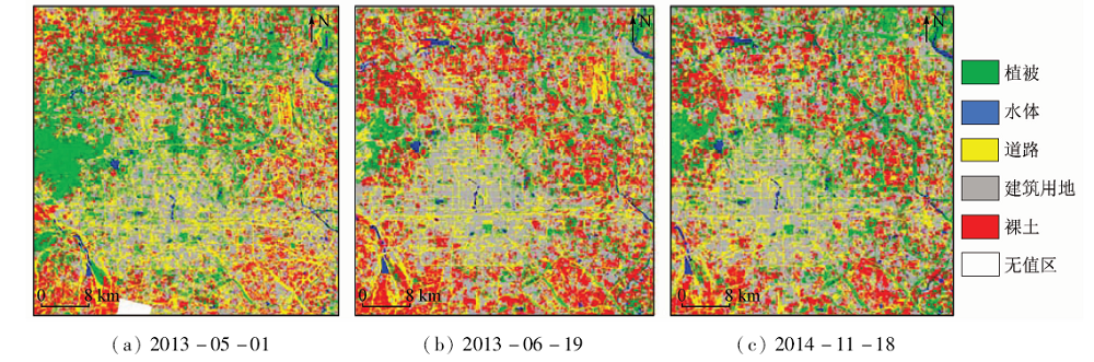
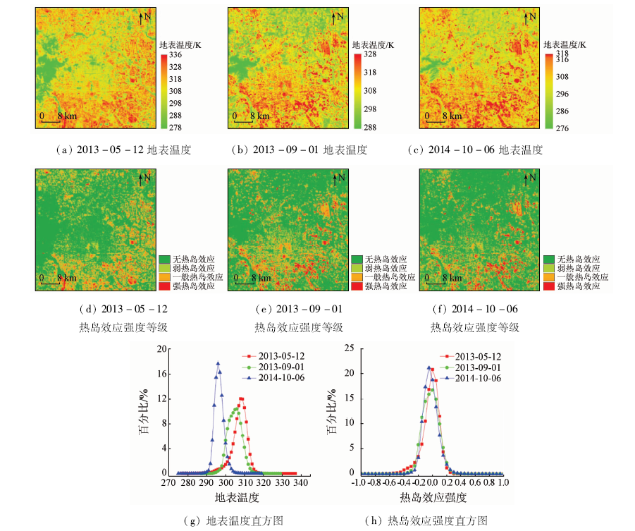
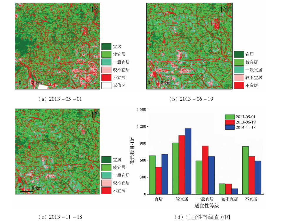
Abstract Based on the remote sensing data, this paper aims to construct an urban environment livability evaluation system on the basis of remote sensing factors and further evaluate the livability of the urban environment. An object-oriented classification method was used to classify urban ecological land into five categories from GF-1 satellite data: water body, vegetation area, road, building land, and bare soil. In addition, the urban surface temperature was retrieved from Landsat8 thermal infrared data and then, the urban thermal environment was calculated. Finally, on the basis of constructing the urban ecological land and urban thermal environment factors, a weight method was used to calculate the ecological quality index (EQI) of the city in order to establish an overall evaluation system of urban environmental livability. Applications in Beijing City showed that, from 2013 to 2014, the urban heat island effect in Beijing was not obvious, and most areas were suitable or basically suitable for human habitation.
|
| Keywords
multi-source remote sening
urban ecological land
urban thermal environment
livability evaluation
|
|
|
|
Corresponding Authors:
REN Huazhong
E-mail: dongjiaji@pku.edu.cn;renhuazhong@pku.edu.cn
|
|
Issue Date: 09 October 2020
|
|
|
| [1] |
田山川. 国外宜居城市研究的理论与方法[J].经济地理, 2008(4):535-538.
|
| [1] |
Tian S C. Theories and methods of livable cities abroad[J].Economic Geography 2008(4):535-538.
|
| [2] |
王思瑶, 刘艳红, 张丽宏. 宜居社区环境评价体系的研究进展[J]. 山西建筑, 2017,43(22):183-185.
|
| [2] |
Wang S Y, Liu Y H, Zhang L H. Research progress on environmental assessment system of livable community[J]. Shanxi Building, 2017,43(22):183-185.
|
| [3] |
Ruut V. The four qualities of life ordering concepts and measures of the good life[M]. Dordrecht:Springer Netherlands, 2013: 195-226.
|
| [4] |
Omuta G E D. The quality of urban life and the perception of livability:A case study of neighbourhoods in Benin City,Nigeria[J]. Social Indicators Research, 1988,20(4):417-440.
doi: 10.1007/BF00302336
url: http://link.springer.com/10.1007/BF00302336
|
| [5] |
Geller A L. Smart growth:A prescription for livable cities[J]. American Journal of Public Health, 2003,93(9):1410-1415.
doi: 10.2105/ajph.93.9.1410
pmid: 12948954
url: https://www.ncbi.nlm.nih.gov/pubmed/12948954
|
| [6] |
Mayer H, Knox P L. Slow cities:Sustainable places in a fast world[J]. Journal of Urban Affairs, 2006,28(4):321-334.
doi: 10.1111/j.1467-9906.2006.00298.x
url: https://www.tandfonline.com/doi/full/10.1111/j.1467-9906.2006.00298.x
|
| [7] |
Okulicz-Kozaryn A. City life:Rankings (livability) versus perceptions (satisfaction)[J]. Social Indicators Research, 2013,110(2):433-451.
doi: 10.1007/s11205-011-9939-x
url: http://link.springer.com/10.1007/s11205-011-9939-x
|
| [8] |
Zanella A, Camanho A S, Dias T G. The assessment of cities’ livability integrating human wellbeing and environmental impact[J]. Annals of Operations Research, 2015,226(1):695-726.
doi: 10.1007/s10479-014-1666-7
url: http://link.springer.com/10.1007/s10479-014-1666-7
|
| [9] |
Leach J M, Lee S E, Boyko C T, et al. Dataset of the livability performance of the city of Birmingham,UK,as measured by its citizen wellbeing,resource security,resource efficiency and carbon emissions[J]. Data in Brief, 2017,15:691-695.
pmid: 29124092
url: https://www.ncbi.nlm.nih.gov/pubmed/29124092
|
| [10] |
Suresh K. What works to make cities good for living?[J]. Journal of Health Management, 2016,18(3):367-380.
doi: 10.1177/0972063416651564
url: http://journals.sagepub.com/doi/10.1177/0972063416651564
|
| [11] |
Ghasemi K, Hamzenejad M, Meshkini A. The spatial analysis of the livability of 22 districts of Tehran Metropolis using multi-criteria decision making approaches[J]. Sustainable Cities and Society, 2018,38:382-404.
doi: 10.1016/j.scs.2018.01.018
url: https://linkinghub.elsevier.com/retrieve/pii/S2210670717314099
|
| [12] |
Mouratidis K. Is compact city livable? The impact of compact versus sprawled neighbourhoods on neighbourhood satisfaction[J]. Urban Studies, 2018,55(11):2408-2430.
doi: 10.1177/0042098017729109
url: http://journals.sagepub.com/doi/10.1177/0042098017729109
|
| [13] |
张文忠. 中国宜居城市建设的理论研究及实践思考[J]. 国际城市规划, 2016,31(5):1-6.
|
| [13] |
Zhang W Z. Theoretical research and practical thinking on the construction of livable cities in China[J]. International Urban Planning, 2016,31(5):1-6.
doi: 10.22217/upi
url: http://www.upi-planning.org/
|
| [14] |
崔凤琪, 唐海萍, 张欣. 京津冀地区城市宜居性评价及影响因素分析:基于2010—2016年面板数据的实证研究[J]. 北京师范大学学报(自然科学版), 2018,54(5):110-117.
|
| [14] |
Cui F Q, Tang H P, Zhang X. Evaluation of urban livability in Beijing-Tianjin-Hebei region and analysis of influencing factors:An empirical study based on panel data from 2010 to 2016[J]. Journal of Beijing Normal University(Natural Science), 2018,54(5):110-117.
|
| [15] |
王迎春, 梁旭东, 苗世光, 等. 城市气象研究动向的思考[J]. 气象, 2012,38(10):1232-1237.
|
| [15] |
Wang Y C, Liang X D, Miao S G, et al. Reflections on the trend of urban meteorological research[J]. Meteorological, 2012,38(10):1232-1237.
|
| [16] |
Kovats R S, Hajat S. Heat stress and public health:A critical review[J]. Annual Review of Public Health, 2008,29(1):41-55.
doi: 10.1146/annurev.publhealth.29.020907.090843
url: http://www.annualreviews.org/doi/10.1146/annurev.publhealth.29.020907.090843
|
| [17] |
White M A, Nemani R R, Thornton P E, et al. Satellite evidence of phenological differences between urbanized and rural areas of the eastern united states deciduous broadleaf forest[J]. Ecosystems, 2002,5(3):260-273.
doi: 10.1007/s10021-001-0070-8
url: http://www.springerlink.com/content/54ej4av22e6hhdjj/
|
| [18] |
Grimm N B, Faeth S H, Golubiewski N E, et al. Global change and the ecology of cities[J]. Science, 2008,319(5864):756-760.
pmid: 18258902
url: https://www.ncbi.nlm.nih.gov/pubmed/18258902
|
| [19] |
Akbari H, Pomerantz M, Taha H. Cool surfaces and shade trees to reduce energy use and improve air quality in urban areas[J]. Solar Energy, 2001,70(3):295-310.
doi: 10.1016/S0038-092X(00)00089-X
url: https://linkinghub.elsevier.com/retrieve/pii/S0038092X0000089X
|
| [20] |
张继平, 乔青, 刘春兰, 等. 基于最小累积阻力模型的北京市生态用地规划研究[J]. 生态学报, 2017,37(19):6313-6321.
doi: 10.5846/stxb201606121121
url: http://www.ecologica.cn/stxb/ch/reader/view_abstract.aspx?file_no=stxb201606121121&flag=1
|
| [20] |
Zhang J P, Qiao Q, Liu C L, et al. Study on ecological land planning in Beijing based on the minimum cumulative resistance model[J]. Acta Ecologica Sinica, 2017,37(19):6313-6321.
|
| [21] |
Fu B, Yu D L, Zhang Y J. The livable urban landscape:GIS and remote sensing extracted land use assessment for urban livability in Changchun Proper,China[J]. Land Use Policy, 2019,87:104048.
doi: 10.1016/j.landusepol.2019.104048
url: https://linkinghub.elsevier.com/retrieve/pii/S0264837719302595
|
| [22] |
Shahtahmassebi A R, Wu C, Blackburn G A, et al. How do modern transportation projects impact on development of impervious surfaces via new urban area and urban intensification? Evidence from Hangzhou Bay bridge,China[J]. Land Use Policy, 2018,77(77):479-497.
doi: 10.1016/j.landusepol.2018.05.059
url: https://linkinghub.elsevier.com/retrieve/pii/S0264837716305701
|
| [23] |
魏伟, 石培基, 冯海春, 等. 干旱内陆河流域人居环境适宜性评价——以石羊河流域为例[J]. 自然资源学报, 2012,27(11):1940-1950.
doi: 10.11849/zrzyxb.2012.11.013
url: http://www.jnr.ac.cn/CN/abstract/abstract2521.shtml
|
| [23] |
Wei W, Shi P J, Feng H C, et al. Evaluation on the suitability of human settlements in arid inland river basin:A case study of Shiyang River basin[J]. Journal of Natural Resources, 2012,27(11):1940-1950.
doi: 10.11849/zrzyxb.2012.11.013
url: http://www.jnr.ac.cn/CN/abstract/abstract2521.shtml
|
| [24] |
中国人民共和国国家环境保护标准. HJ 192—2015生态环境状况评价技术规范[S].北京: 中国环境科学出版社, 2015.
|
| [24] |
National Environmental Protection Standards of the People’s Republic of China. HJ 192-2015 Technical Specification of the Evaluation of the Ecological Environment[S]. Beijing: China Environmental Science Press, 2015.
|
| [25] |
刘建华, 毛政元. 高空间分辨率遥感影像分割方法研究综述[J].遥感信息, 2009(6):95-101.
url: http://d.wanfangdata.com.cn/Periodical_ygxx200906020.aspx
|
| [25] |
Liu J H, Mao Z Y. Review of the method of segmentation of remote sensing images with high spatial resolution[J].Remote Sensing Information 2009(6):95-101.
url: http://d.wanfangdata.com.cn/Periodical_ygxx200906020.aspx
|
| [26] |
汪求来. 面向对象遥感影像分类方法及其应用研究[D]. 南京:南京林业大学, 2008.
|
| [26] |
Wang Q L. Object-oriented remote sensing image classification method and application[D]. Nanjing:Nanjing Forestry University, 2008.
|
| [27] |
张佳, 谢玉凤. 高光谱遥感影像分类方法综述[J].安徽农学通报, 2017,25(14):155,165.
|
| [27] |
Zhang J, Xie Y F. Overview of classification methods of hyperspectral remote sensing images[J].Anhui Agricultural Science Bulletin, 2017,25(14):155,165.
|
| [28] |
McFeeters S K. The use of the normalized difference water index (NDWI) in the delineation of open water features[J]. International Journal of Remote Sensing, 1996,17(7):1425-1432.
doi: 10.1080/01431169608948714
url: https://www.tandfonline.com/doi/full/10.1080/01431169608948714
|
| [29] |
Rouse Jr J W, Haas R, Schell J, et al. Monitoring vegetation systems in the Great Plains with ERTS[J]. NASA Special Publication, 1974,1:309-317.
|
| [30] |
雷小奇, 王卫星, 赖均. 一种基于形状特征进行高分辨率遥感影像道路提取方法[J]. 测绘学报, 2009,38(5):457-465.
|
| [30] |
Lei X Q, Wang W X, Lai J. A road extraction method based on shape features for high-resolution remote sensing images[J]. Journal of Surveying and Mapping, 2009,38(5):457-465.
|
| [31] |
何江. 超高分辨率遥感影像城市建筑物和道路分类研究[D]. 兰州:兰州大学, 2019.
|
| [31] |
He J. Study on classification of urban buildings and roads in ultra-high resolution remote sensing images[D]. Lanzhou:Lanzhou University, 2019.
|
| [32] |
谢嘉丽, 李永树, 李何超, 等. 利用灰度共生矩阵纹理特征识别空心村损毁建筑物的方法[J].测绘通报, 2017(12):90-93,102.
|
| [32] |
Xie J L, Li Y S, Li H C, et al. Method of identifying damaged buildings in hollow villages by using the texture features of gray scale symbiotic matrix[J].Surveying and Mapping Advisory 2017(12):90-93,102.
|
| [33] |
薛晓娟, 孟庆岩, 王春梅, 等. 北京市热岛效应时空变化的HJ-1B监测分析[J]. 地球信息科学学报, 2012,14(4):474-480.
doi: 10.3724/SP.J.1047.2012.00474
url: http://www.dqxxkx.cn/CN/abstract/abstract10031.shtml
|
| [33] |
Xue X J, Meng Q Y, Wang C M, et al. HJ-1B monitoring and analysis of temporal and spatial variation of heat island effect in Beijing[J]. Journal of Earth Information Science, 2012,14(4):474-480.
|
| [34] |
Du C, Ren H Z, Qin Q M, et al. A practical split-window algorithm for estimating land surface temperature from Landsat8 data[J]. Remote Sensing, 2015,7(1):647-665.
doi: 10.3390/rs70100647
url: http://www.mdpi.com/2072-4292/7/1/647
|
|
Viewed |
|
|
|
Full text
|
|
|
|
|
Abstract
|
|
|
|
|
Cited |
|
|
|
|
| |
Shared |
|
|
|
|
| |
Discussed |
|
|
|
|
 2020,
Vol. 32
2020,
Vol. 32