|
|
|
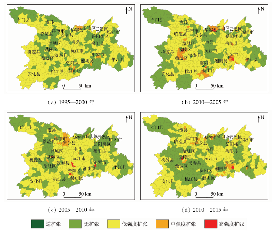
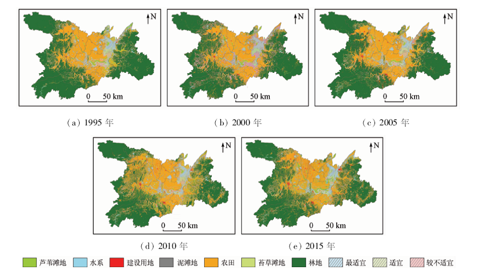
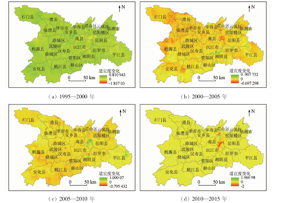
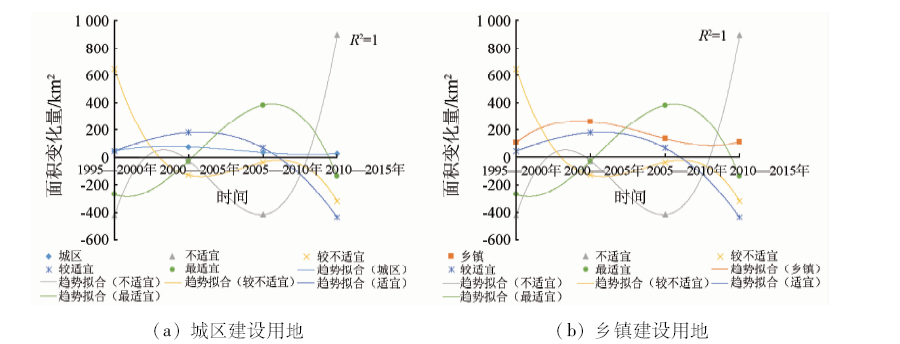
Abstract The deterioration of habitats caused by urbanization is an important reason for biodiversity loss. Based on Landsat TM/OLI images, DEM, digital maps and local climatic data from 1995 to 2015, the authors constructed the image interpretation system of Dongting Lake area, which was based on CART acquisition rules. According to the LUCC data obtained, the authors analyzed the spatio-temporal difference and correction of urbanization and avian habitat in Dongting Lake area, with the support of the software such as ENVI, ArcGIS, and MaxEnt. The results show that the classification method based on the CART algorithm for acquisition rule gained a higher precision than the ordinary classification method. The construction land in lake area increased by 808.61 km 2 in 20 years, the high-intensity expansion area was spread from the urban center to the county-level city, and the expansion rate gradually decreased after 2005. In the past 20 years, the suitable habitat area of waterfowls has decreased by 195.19 km 2, and the overall suitability of this area has been declined. However, the situation has gradually improved since 2000 with the government’s efforts to rectify the environment. The results of polynomial fitting and spatial comparison indicate that rapid and disorderly expansion of township construction land has reduced the suitability of avian habitats in lake area, and that, to protect avian habitats, people should take effective measures to protect the ecological land around there and rationally plan and control the expansion of construction land in towns and village areas.
|
| Keywords
Dongting Lake
CART decision tree
urbanization
avian habitat
spatio-temporal difference
|
|
|
|
Corresponding Authors:
QI Zengxiang
E-mail: 1341438323@qq.com;qizengxiang@126.com
|
|
Issue Date: 09 October 2020
|
|
|
| [1] |
邹鹏飞. 基于RS和GIS的城镇化扩展时空特征及驱动力分析[D].北京:中国地质大学(北京),2016.
|
| [1] |
Zou P F. Analysis of spatial and temporal characteristics and driving force of urbanization based on RS and GIS[D].Beijing:China University of Geosciences(Beijing), 2016.
|
| [2] |
魏辅文, 聂永刚, 苗海霞, 等. 生物多样性丧失机制研究进展[J]. 科学通报, 2014,59(6):430-437.
|
| [2] |
Wei F W, Nie Y G, Miao H X, et al. Advancements of the researches on biodiversity loss mechanisms[J]. Chinese Science Bulletin, 2014,59(6):430-437.
|
| [3] |
Venn,S, K J, Niemelä J. Urbanization effects on carabid diversity in boreal forests[J]. European Journal of Entomology, 2013,100(1):73-80.
doi: 10.14411/eje.2003.015
url: http://www.eje.cz/doi/10.14411/eje.2003.015.html
|
| [4] |
Xiao L, Wang W, He X, et al. Urban-rural and temporal differences of woody plants and bird species in Harbin City,northeastern China[J]. Urban Forestry & Urban Greening, 2016,13(7):20-31.
|
| [5] |
Perrier C, Campo A L D, Szulkin M, et al. Great tits and the city:Distribution of genomic diversity and gene-environment associations along an urbanization gradient[J]. Evolutionary Applications, 2018,11(5):593-613.
pmid: 29875805
url: https://www.ncbi.nlm.nih.gov/pubmed/29875805
|
| [6] |
Jung K, Kalko E K V. Adaptability and vulnerability of high flying neotropical aerial insectivorous bats to urbanization[J]. Diversity & Distributions, 2015,17(2):262-274.
|
| [7] |
Germaine S S, Wakeling B F. Lizard species distributions and habitat occupation along an urban gradient in Tucson,Arizona,USA[J]. Biological Conservation, 2001,97(2):229-237.
|
| [8] |
Clucas B, Marzluff J M. A cross-continental look at the patterns of avian species diversity and composition across an urbanisation gradient[J]. Wildlife Research, 2015,42(7):554-562.
|
| [9] |
La Sorte F A, Lepczyk C A, Aronson M F J, et al. The phylogenetic and functional diversity of regional breeding bird assemblages is reduced and constricted through urbanization[J]. Diversity and Distributions, 2018,24(7):928-938.
doi: 10.1111/ddi.2018.24.issue-7
url: http://doi.wiley.com/10.1111/ddi.2018.24.issue-7
|
| [10] |
Lövei G L, Horváth R, Elek Z, et al. Diversity and assemblage filtering in ground-dwelling spiders (Araneae) along an urbanisation gradient in Denmark[J]. Urban Ecosystems, 2019,22(2):345-353.
doi: 10.1007/s11252-018-0819-x
url: https://doi.org/10.1007/s11252-018-0819-x
|
| [11] |
Wu Y H, Gu C B, Li W B, et al. The influence of urbanization on butterfly diversity in Hefei,Anhui Province[J]. Chinese Journal of Ecology, 2016,35(4):992-996.
url: http://www.cje.net.cn/CN/abstract/abstract7940.shtml
|
| [12] |
刘云珠, 史林鹭. 人为干扰下西洞庭湖湿地景观格局变化及冬季水鸟的响应[J]. 生物多样性, 2013,21(6):666-676.
doi: 10.3724/SP.J.1003.2013.11090
url: http://www.biodiversity-science.net/CN/abstract/abstract9829.shtml
|
| [12] |
Liu Y Z, Shi L L. Disturbance-driven changes to landscape patterns and responses of waterbirds at west Dongting Lake[J]. Biodiversity Science, 2013,21(6):666-676.
doi: 10.3724/SP.J.1003.2013.11090
url: http://www.biodiversity-science.net/CN/abstract/abstract9829.shtml
|
| [13] |
Vittorio M D, Ciaccio A, Grenci S, et al. Ecological modelling of the distribution of the lanner falcon Falco feldeggii in Sicily at two spatial scales[J]. Ardeola, 2015,62(1):81-94.
|
| [14] |
于沿泽, 吴新宇, 尹冬冬, 等. 基于MAXENT生态位模型对内蒙古根河地区驼鹿生境适宜性评价[J]. 林业科技, 2019,44(2):1-4.
|
| [14] |
Yu Y Z, Wu X Y, Yin D D, et al. Suitability evaluation of moose habitat in Genhe area of Inner Mongolia based on MAXENT model[J]. Forestry Science & Technology, 2019,44(2):1-4.
|
| [15] |
Yang F, He D H. Effects of habitat fragmentation on biodiversity[J]. Annual Review of Ecology Evolution & Systematics, 2003,34(2):487-515.
doi: 10.1146/annurev.ecolsys.34.011802.132419
url: http://www.annualreviews.org/doi/10.1146/annurev.ecolsys.34.011802.132419
|
| [16] |
贾慧聪, 潘东华, 张万昌. 洞庭湖区近30年土地利用/覆盖变化对湿地的影响分析[J]. 中国人口·资源与环境, 2014,24(s3):126-128.
|
| [16] |
Jia H C, Pan D H, Zhang W C. Study on land use/cover change impact on wetlands of Dongting Lake area for nearly 30 years[J]. China Population,Resources and Environment, 2014,24(s3):126-128.
|
| [17] |
庄大昌. 洞庭湖湿地生态系统服务功能价值评估[J]. 经济地理, 2004,24(3):391-394,432.
|
| [17] |
Zhuang D C. The evaluation of the ecosystem service value in Dongting Lake wetland[J].Economic Geograph 2004(3):391-394,432.
|
| [18] |
蒋卫国, 潘英姿, 侯鹏, 等. 洞庭湖区湿地生态系统健康综合评价[J]. 地理研究, 2009,28(6):1665-1672.
url: http://www.dlyj.ac.cn/CN/abstract/abstract8787.shtml
|
| [18] |
Jiang W G, Pan Y Z, Hou P, et al. Assessment and analysis of wetland ecosystem health in Dongting Lake[J]. Geographical Research, 2009,28(6):1665-1672.
|
| [19] |
陈云, 戴锦芳, 李俊杰. 基于影像多种特征的CART决策树分类方法及其应用[J].地理与地理信息科学, 2008(2):33-36.
url: http://d.wanfangdata.com.cn/Periodical_dlxygtyj200802009.aspx
|
| [19] |
Chen Y, Dai J F, Li J J. CART-based decision tree classifier using multi-feature of image and its application[J]. Geography and Geo-Information Science, 2008,24(2):33-36.
|
| [20] |
许仲林, 彭焕华, 彭守璋. 物种分布模型的发展及评价方法[J]. 生态学报, 2015,35(2):557-567.
|
| [20] |
Xu Z L, Peng H H, Peng S Z. The development and evaluation of species distribution models[J]. Acta Ecologica Sinica, 2015,35(2):557-567.
|
| [21] |
汪松, 解焱. 中国物种红色名录(第一卷)[M]. 北京: 高等教育出版社, 2004.
|
| [21] |
Wang S, Xie Y. China species red list (Vol.I)[M]. Beijing: Higher Education Press, 2004.
|
| [22] |
朱耿平, 刘国卿, 卜文俊, 等. 生态位模型的基本原理及其在生物多样性保护中的应用[J]. 生物多样性, 2013,21(1):90-98.
doi: 10.3724/SP.J.1003.2013.09106
url: http://www.biodiversity-science.net/CN/abstract/abstract9674.shtml
|
| [22] |
Zhu G P, Liu G Q, Bu W J, et al. Ecological niche modeling and its applications in biodiversity conservation[J]. Biodiversity Science, 2013,21(1):90-98.
doi: 10.3724/SP.J.1003.2013.09106
url: http://www.biodiversity-science.net/CN/abstract/abstract9674.shtml
|
| [23] |
熊巧利, 何云玲, 邓福英, 等. 基于MaxEnt模型西南地区高山植被对气候变化的响应评估[J]. 生态学报, 2019,39(24):1-11.
|
| [23] |
Xiong Q L, He Y L, Deng F Y, et al. Assessment of alpine mean response to climate change in Southwest China based on MaxEnt model[J]. Acta Ecologica Sinica, 2019,39(24):1-11.
|
| [24] |
李涛, 齐增湘, 王宽, 等. 1990—2013年来洞庭湖区鸟类生物多样性热点区时空动态及变动机理[J]. 长江流域资源与环境, 2017,26(11):1902-1911.
|
| [24] |
Li T, Qi Z X, Wang K, et al. Spatio-temporal dynamic and mechanism of avian biodiversity hotpots in Dongting Lake region during 1990—2013[J]. Resources and Environment in the Yangtze Basin, 2017,26(11):1902-1911.
|
|
Viewed |
|
|
|
Full text
|
|
|
|
|
Abstract
|
|
|
|
|
Cited |
|
|
|
|
| |
Shared |
|
|
|
|
| |
Discussed |
|
|
|
|
 2020,
Vol. 32
2020,
Vol. 32
 ), QI Zengxiang(