|
|
 |
|

|
|
|
Using SVM classify Landsat image to analyze the spatial and temporal characteristics of main urban expansion analysis in Democratic People’s Republic of Korea |
WANG Xiaolong1,2,3( ), YAN Haowen1,2,3(), ZHOU Liang1,2,3, ZHANG Liming1,2,3, DANG Xuewei1,2,3 ), YAN Haowen1,2,3(), ZHOU Liang1,2,3, ZHANG Liming1,2,3, DANG Xuewei1,2,3 |
1. Faculty of Geomatics, Lanzhou Jiaotong University, Lanzhou 730070, China
2. National-Local Joint Engineering Research Center of Technologies and Applications for National Geographic State Monitoring, Lanzhou 730070, China
3. Gansu Provincial Engineering Laboratory for National Geographic State Monitoring, Lanzhou 730070, China |
|
|
|
|
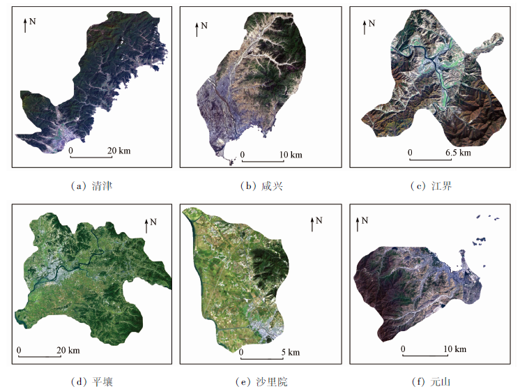
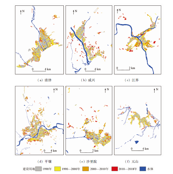
Abstract The study of the change of main urban construction land that is almost blank in the wide area space-time scale can make up for the blank in the wide area space-time scale in the study area. The construction land of six major cities was extracted by using SVM classification method based on the Landsat TM/ETM+/OLI data of long time series from 1990 to 2018 in the study area. The quantitative analysis was made on the landscape metric as well as annual increase and annual growth rate urban development mode. The results show that the SVM method can effectively extract the construction land, with the average of overall accuracy higher than 90% and Kappa more than 0.87. The area expansion of each urban area had reached 1.2~1.4 times and was growing continuously from 1990 to 2018. The annual growth that the largest among the six cities of Pyongyang has reached 1.15 km2, while the growth rate of Wosan has a small fluctuation range. And the growth rate that the largest among the six cities of Humhang has reached 2.74% in the recent period. The expansion of six cities in the study area is concentrated in the flat terrain,and the main urban area is distributed along the river or the coast, with the expansion mode of filling type and filling type. In general, its urbanization process is on the rise. This study lays the foundation for the ecological environment protection and the urban expansion and provides reference for the relevant scientific research in the study area.
|
| Keywords
SVM
urbanization
construction land
landscape metrics
Democratic People’s Republic of Korea
|
|
|
|
Corresponding Authors:
YAN Haowen
E-mail: 1724812353@qq.com;haowen2010@gmail.com
|
|
Issue Date: 23 December 2020
|
|
|
| [1] |
Wehrwhein G S. The rural-urban fringe[J]. Economic Geography, 1942,18(3):217-228.
doi: 10.2307/141123
url: https://www.jstor.org/stable/141123?origin=crossref
|
| [2] |
Adams J S. Residential structure of mid-western cities[J]. Annals of the Association of American Geographers, 1970,60(1):37-62.
doi: 10.1111/j.1467-8306.1970.tb00703.x
url: http://www.tandfonline.com/doi/abs/10.1111/j.1467-8306.1970.tb00703.x
|
| [3] |
Puertas O L, Henriquez C, Meza F J. Assessing spatial dynamics of urban growth using an integrated land use model.Application in Santiago Metropolitan Area,2010—2045[J]. Land Use Policy, 2014,38:415-425.
doi: 10.1016/j.landusepol.2013.11.024
url: http://dx.doi.org/10.1016/j.landusepol.2013.11.024
|
| [4] |
Jiao L, Liu J, Xu G, et al. Proximity expansion index:An improved approach to characterize evolution process of urban expansion[J]. Computers,Environment and Urban Systems, 2018,70:102-112.
doi: 10.1016/j.compenvurbsys.2018.02.005
url: https://linkinghub.elsevier.com/retrieve/pii/S0198971517300662
|
| [5] |
Alberti M, Waddell P. An integrated urban development and ecological simulation model[J]. Integrated Assessment, 2000,1(3):215-227.
doi: 10.1023/A:1019140101212
url: http://link.springer.com/10.1023/A:1019140101212
|
| [6] |
Chen L, Yang X, Chen L, et al. Impact assessment of land use planning driving forces on environment[J]. Environmental Impact Assessment Review, 2015,55:126-135.
|
| [7] |
岳文泽, 徐建华, 武佳卫, 等. 基于线性光谱分析的城市旧城改造空间格局遥感研究:以1997—2000年上海中心城区为例[J]. 科学通报, 2006,51(8):966-974.
|
| [7] |
Yue W Z, Xue J H, Wu J W, et al. Remote sensing study on spatial pattern of urban old city transformation based on linear spectral analysis:A case study of Shanghai’s central city in 1997—2000[J]. Science Bulletin, 2006,51(8):966-974.
|
| [8] |
周存林, 徐涵秋. 福州城区不透水面的光谱混合分析与识别制图[J]. 中国图象图形学报, 2007,12(5):875-881.
doi: 10.11834/jig.20070518
url: http://www.cjig.cn/jig/ch/reader/view_abstract.aspx?file_no=200705143&flag=1
|
| [8] |
Zhou C L, Xu H Q. Spectral mixture analysis and recognition mapping of impervious surface in Fuzhou City[J]. Journal of Image and Graphics, 2007,12(5):875-881
|
| [9] |
谢苗苗, 王仰麟, 李贵才. 基于亚像元分解的不透水表面与植被覆盖空间分异测度——以深圳市为例[J]. 资源科学, 2009,31(2):83-90.
|
| [9] |
Xie M M, Wang Y L, Li G C. Spatial differentiation measurement of impervious surface and vegetation cover based on sub-pixel decomposition:A case study of Shenzhen City[J]. Resources Science, 2009,31(2):83-90.
|
| [10] |
徐涵秋. 城市不透水面与相关城市生态要素关系的定量分析[J]. 生态学报, 2009,29(5):2456-2462.
url: http://www.ecologica.cn/stxb/ch/reader/view_abstract.aspx?file_no=20090532&flag=1
|
| [10] |
Xu H Q. Quantitative analysis of the relationship between urban impervious surface and related urban ecological factors[J]. Acta Ecologica Sinica, 2009,29(5):2456-2462.
|
| [11] |
曹丽琴, 李平湘, 张良培, 等. Fuzzy ARTMAP算法在城市不透水面估算中的应用研究[J]. 武汉大学学报(信息科学版), 2012,37(10):1236-1239.
|
| [11] |
Cao L Q, Li P X, Zhang L P, et al. Estimating impervious surfaces using the Fuzzy ARTMAP[J]. Geomatics and Information Science of Wuhan University, 2012,37(10):1236-1239.
|
| [12] |
Xu H Q. Rule-based impervious surface mapping using high spatial resolution imagery[J]. International Journal of Remote Sensing, 2013,34(1):27-44.
|
| [13] |
Singh P P, Garg R D. A two-stage framework for road extraction from high-resolution satellite images by using prominent features of impervious surfaces[J]. International Journal of Remote Sensing, 2014,35(24):8074-8107.
|
| [14] |
高志宏, 张路, 李新延, 等. 城市土地利用变化的不透水面覆盖度检测方法[J]. 遥感学报, 2010,14(3):593-606.
|
| [14] |
Gao Z H, Zhang L, Li X Y. Detection method of impervious surface coverage of urban land use change[J]. Journal of Remote Sensing, 2010,14(3):593-606.
|
| [15] |
张路, 高志宏, 廖明生, 等. 利用多源遥感数据进行城市不透水面覆盖度估算[J]. 武汉大学学报(信息科学版), 2010,35(10):1212-1216.
|
| [15] |
Zhang L, Gao Z H, Liao M S, et al. Estimation of urban impervious surface coverage using multi-source remote sensing data[J]. Geomatics and Information Science of Wuhan University, 2010,35(10):1212-1216.
|
| [16] |
Pijanowski B C, Brown D G, Shellito B A, et al. Using neural networks and GIS to forecast land use changes:A land transformation model[J]. Computers Environment and Urban Systems, 2002,26(6):553-575.
|
| [17] |
Tayyebi A, Pijanowski B C, Tayyebi A H. An urban growth boundary model using neural networks,GIS and radial parameterization:An application to Tehran,Iran[J]. Landscape and Urban Planning, 2011,100(1-2):35-44.
|
| [18] |
Tian G, Ma B, Xu X, et al. Simulation of urban expansion and encroachment using cellular automata and multi-agent system model:A case study of Tianjin metropolitan region,China[J]. Ecological Indicators, 2016,70:439-450.
|
| [19] |
Mohammady S, Delavar M R. Urban sprawl assessment and modeling using landsat images and GIS[J]. Modeling Earth Systems and Environment, 2016,2(3):155.
|
| [20] |
Batty M, Xie Y, Sun Z. Modeling urban dynamics through GIS-based cellular automata[J]. Computers,Environment and Urban Systems, 1999,23(3):205-233.
|
| [21] |
Vaz E D N, Nijkamp P, Painho M, et al. A multi-scenario forecast of urban change:A study on urban growth in the Algarve[J]. Landscape and Urban Planning, 2012,104(2):201-211.
|
| [22] |
Feng Y, Liu Y, Batty M. Modeling urban growth with GIS based cellular automata and least squares SVM rules:A case study in Qingpu-Songjiang area of Shanghai,China[J]. Stochastic Environmental Research and Risk Assessment, 2016,30(5):1387-1400.
|
| [23] |
Shirzadi Babakan A, Taleai M. Impacts of transport development on residence choice of renter households:An agent-based evaluation[J]. Habitat International, 2015,49:275-285.
|
| [24] |
Hosseinali F, Alesheikh A A, Nourian F. Agent-based modeling of urban land-use development, case study:Simulating future scenarios of Qazvin City[J]. Cities, 2013,31:105-113.
|
| [25] |
Murray-Rust D, Rieser V, Robinson D T, et al. Agent-based modelling of land use dynamics and residential quality of life for future scenarios[J]. Environmental Modelling and Software, 2013,6(46):75-89.
|
| [26] |
王浩, 卢善龙, 吴炳方, 等. 不透水面遥感提取及应用研究进展[J]. 地球科学进展, 2013,28(3):327-336.
|
| [26] |
Wang H, Lu S L, Wu B F, et al. Research progress in remote sensing extraction and application of impervious surface[J]. Advances in Earth Science, 2013,28(3):327-336.
|
| [27] |
Musa S I, Hashim M, Reba M N M. A review of geospatial-based urban growth models and modelling initiatives[J]. Geocarto International, 2017,32(8):813-833.
|
| [28] |
Karimi F, Sultana S, Babakan A S, et al. An enhanced support vector machine model for urban expansion prediction[J]. Computers,Environment and Urban Systems, 2019,75:61-75.
|
| [29] |
Munoz-Mari J, Bocolo F, Gmez-Chova L, et al. Semisupervised one-class support vector machines for classification of remote sensing data[J]. IEEE Transactions on Geoscience and Remote Sensing, 2010,48(8):3188-3197.
|
| [30] |
崔林林, 罗毅, 包安明. NWFE结合纹理特征的SVM土地覆被分类方法研究[J]. 国土资源遥感, 2012,24(1):36-42.doi: 10.6046/gtzyyg.2012.01.07.
|
| [30] |
Cui L L, Luo Y, Bao A M. Study on SVM land cover classification method based on NWFE texture features[J]. Remote Sensing for Land and Resources, 2012,24(1):36-42.doi: 10.6046/gtzyyg.2012.01.07.
|
| [31] |
邓曾, 李丹, 柯樱海, 等. 基于改进SVM算法的高分辨率遥感影像分类[J]. 国土资源遥感, 2016,28(3):12-18.doi: 10.6046/gtzyyg.2016.03.03.
|
| [31] |
Deng Z, Li D, Ke Y H, et al. An improved SVM algorithm for high spatial resolution remote sensing image classification[J]. Remote Sensing for Land and Resources, 2016,28(3):12-18.doi: 10.6046/gtzyyg.2016.03.03.
|
| [32] |
董禹麟, 于皓, 王宗明, 等. 1990—2015年朝鲜土地覆被变化及驱动力分析[J]. 自然资源学报, 2019,34(2):70-82.
|
| [32] |
Dong Y L, Yu H, Wang Z M, et al. Analysis of land cover change and driving forces in North Korea from 1990 to 2015[J]. Journal of Natural Resources, 2019,34(2):70-82.
|
| [33] |
关兴良, 方创琳, 周敏, 等. 武汉城市群城镇用地空间扩展时空特征分析[J]. 自然资源学报, 2012,27(9):1447-1459.
doi: 10.11849/zrzyxb.2012.09.002
url: http://www.jnr.ac.cn/CN/abstract/abstract2471.shtml
|
| [33] |
Guan X L, Fang C L, Zhou M, et al. Analysis of spatial and temporal characteristics of urban land use in Wuhan Urban Agglomeration[J]. Journal of Natural Resources, 2012,27(9):1447-1459.
doi: 10.11849/zrzyxb.2012.09.002
url: http://www.jnr.ac.cn/CN/abstract/abstract2471.shtml
|
| [34] |
Ridd K M. Exploring a V-I-S (vegetation-impervious surface-soil) model for urban ecosystem analysis through remote sensing:Comparative anatomy for cities[J]. International Journal of Remote Sensing, 1995,6(12):2165-2185.
|
| [35] |
Vapnik V. Pattern recognition using generalized portrait method[J]. Automation and Remote Control, 1963,24:774-780.
|
| [36] |
Boser B E, Guyon I M, Vapnik V N. A training algorithm for optimal margin classifiers[C]// Proceedings of the Fifth Annual Workshop on Computational Learning Theory.ACM, 1992:144-152.
|
| [37] |
Foody G M, Mathur A. A relative evaluation of multiclass image classification by support vector machines[J]. IEEE Transactions on Geoscience and Remote Sensing, 2004,42(6):1335-1343.
doi: 10.1109/TGRS.2004.827257
url: http://ieeexplore.ieee.org/document/1304900/
|
| [38] |
李楠, 朱秀芳, 潘耀忠, 等. 人工蜂群算法优化的SVM遥感影像分类[J]. 遥感学报, 2018,22(4):29-39.
|
| [38] |
Li N, Zhu X F, Pan Y Z, et al. SVM remote sensing image classification optimized by artificial bee colony algorithm[J]. Journal of Remote Sensing, 2018,22(4):29-39.
|
| [39] |
Chapelle O, Vapnik V, Bousquet O, et al. Choosing multiple parameters for support vector machines[J]. Machine Learning, 2002,46(1-3):131-159.
doi: 10.1023/A:1012450327387
url: http://link.springer.com/10.1023/A:1012450327387
|
| [40] |
Seto K C, Woodcock C E, Song C, et al. Monitoring land-use change in the Pearl River Delta using Landsat TM[J]. International Journal of Remote Sensing, 2002,23(10):1985-2004.
doi: 10.1080/01431160110075532
url: https://www.tandfonline.com/doi/full/10.1080/01431160110075532
|
| [41] |
何春阳, 陈晋, 陈云浩, 等. 土地利用/覆盖变化混合动态监测方法研究[J]. 自然资源学报, 2001,16(3):255-262.
doi: 10.11849/zrzyxb.2001.03.010
url: http://www.jnr.ac.cn/CN/abstract/abstract1396.shtml
|
| [41] |
He C Y, Chen J, Chen Y H, et al. Study on the hybrid dynamic monitoring method of land use/cover change[J]. Journal of Natural Resources, 2001,16(3):255-262.
doi: 10.11849/zrzyxb.2001.03.010
url: http://www.jnr.ac.cn/CN/abstract/abstract1396.shtml
|
| [42] |
张亦汉, 黎夏, 刘小平, 等. 耦合遥感观测和元胞自动机的城市扩张模拟[J]. 遥感学报, 2013,17(4):872-886.
doi: 10.11834/jrs.20132169
url: http://www.jors.cn/jrs/ch/reader/view_abstract.aspx?file_no=r12169&flag=1
|
| [42] |
Zhang Y H, Li X, Liu X P, et al. Simulation of urban expansion by coupling remote sensing observation and cellular automata[J]. Journal of Remote Sensing, 2013,17(4):872-886.
doi: 10.11834/jrs.20132169
url: http://www.jors.cn/jrs/ch/reader/view_abstract.aspx?file_no=r12169&flag=1
|
| [43] |
Li X, Yeh A G O. Principal component analysis of stacked multi-temporal images for the monitoring of rapid urban expansion in the Pearl River Delta[J]. International Journal of Remote Sensing, 1998,19(8):1501-1518.
doi: 10.1080/014311698215315
url: https://www.tandfonline.com/doi/full/10.1080/014311698215315
|
| [44] |
Chang C C, Lin C J. LIBSVM:A library for support vector machines[J]. ACM Transactions on Intelligent Systems and Technology(TIST), 2011,2(3):27.
|
| [45] |
张锦水, 何春阳, 潘耀忠, 等. 基于SVM的多源信息复合的高空间分辨率遥感数据分类研究[J]. 遥感学报, 2006,10(1):49-57.
doi: 10.11834/jrs.20060108
url: http://www.jors.cn/jrs/ch/reader/view_abstract.aspx?file_no=20060108&flag=1
|
| [45] |
Zhang J S, He C Y, Pan Y Z, et al. SVM based classification of high spatial resolution remote sensing data with multi-source information integration[J]. Journal of Remote Sensing, 2006,10(1):49-57.
doi: 10.11834/jrs.20060108
url: http://www.jors.cn/jrs/ch/reader/view_abstract.aspx?file_no=20060108&flag=1
|
| [46] |
Pan T, Deng S L, Chi Z, et al. Urban land-cover dynamics in arid China based on high-resolution urban land mapping products[J]. Remote Sensing, 2017,9(7):730.
doi: 10.3390/rs9070730
url: http://www.mdpi.com/2072-4292/9/7/730
|
| [47] |
Mcgaridal K, Marks B J. FRAGSTATS:Spatial pattern analysis program for quantifying landscape structure[J]. General Technical Report PNW, 1995,351.
|
| [48] |
Fei W, Zhao S. Urban land expansion in China’s six megacities from 1978 to 2015[J]. Science of the Total Environment, 2019,664:60-71.
|
| [49] |
Zhao S, Zhou D, Zhu C, et al. Rates and patterns of urban expansion in China’s 32 major cities over the past three decades[J]. Landscape Ecology, 2015,30(8):1541-1559.
|
| [50] |
禹丝思, 孙中昶, 郭华东, 等. 海上丝绸之路超大城市空间扩展遥感监测与分析[J]. 遥感学报, 2017,21(2):169-181.
|
| [50] |
Yu S S, Sun Z C, Guo D H, et al. Remote sensing monitoring and analysis of spatial expansion of mega cities along the maritime Silk Road[J]. Journal of Remote Sensing, 2017,21(2):169-181.
|
|
Viewed |
|
|
|
Full text
|
|
|
|
|
Abstract
|
|
|
|
|
Cited |
|
|
|
|
| |
Shared |
|
|
|
|
| |
Discussed |
|
|
|
|
 2020,
Vol. 32
2020,
Vol. 32