|
|
 |
|

|
|
|
Urban ecological environment evaluation based on Tiangong-2 and Landsat8 data |
MUHADAISI Ariken1,2( ), ZHANG Fei1,2,3(), LIU Kang4, AYINUER Yushanjiang1,2 ), ZHANG Fei1,2,3(), LIU Kang4, AYINUER Yushanjiang1,2 |
1. Key Laboratory of Wisdom City and Environment Modeling of Higher Education Institute, College of Resources and Environmental Science, Xinjiang University, Urumqi 830046, China
2. Key Laboratory of Oasis Ecology, Xinjiang University, Urumqi 830046, China
3. Engineering Research Center of Central Asia Geoinformation Development and Utilization, National Administration of Surveying, Mapping and Geoinformation, Urumqi 830002, China
4. Technology and Engineering Center for Space Utilization, Key Laboratory of Space Utilization, Chinese Academy of Sciences, Beijing 100094, China |
|
|
|
|
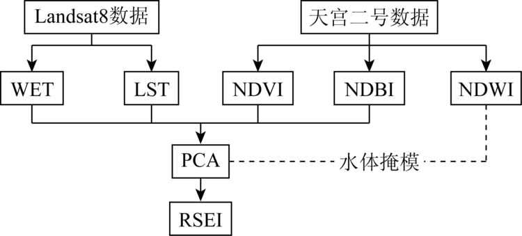
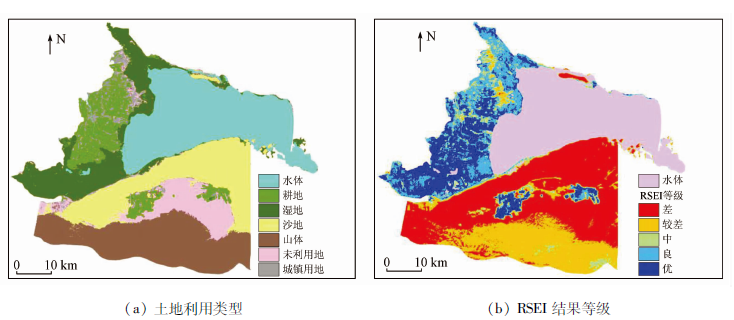
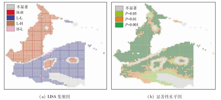
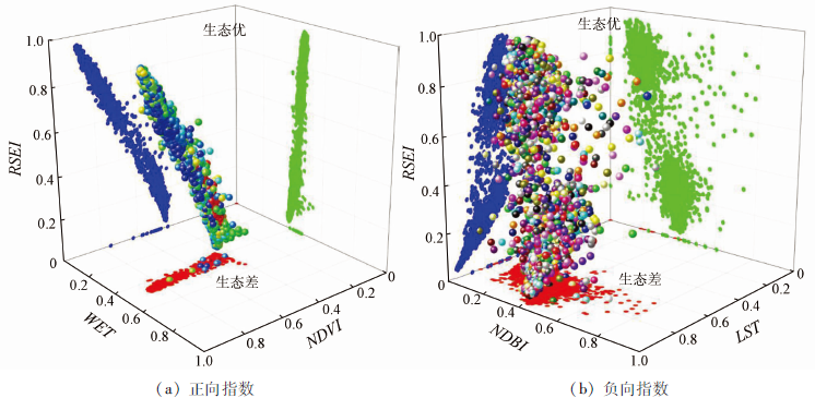
Abstract At present, China has entered into the rapid development stage of urbanization, and urbanization is exerting its positive effect. Such a situation inevitably brings negative effects, but remote sensing technique can quickly, accurately, objectively and quantitatively reveal the present situation of the regional ecological environment quality. Bohu County is one of the most typical areas in arid oasis in Northwest China. Based on Tiangong-2 wide-band images spectrometer and Landsat8 images, the authors constructed a multi-factor comprehensive index RSEI evaluation model in combination with principal components, which was established to evaluate the ecological environment of Bohu County. Additionally, the authors explored the application of Tiangong-2 wide-band images to ecological environment monitoring. The result shows that the greenness (NDVI) and wetness (WET) have positive effects on promoting the ecological environment quality, while the heat (LST) and dryness (NDBI) have restraining effects on ecological environment quality. Greenness (NDVI) has a greater impact on the ecological environment than the other three indicators. In 2018, the RSEI poor grade (0 ~ 0.2) in Bohu County was mainly distributed over urban land and unused land in the north;the fair grade (0.2 ~ 0.4) was mainly distributed among mountains and sandy land. Quantitative and qualitative analysis shows that the driving factors included urban economic development, higher average temperature, greater evaporation, longer sunshine and other natural factors. The ecological environment of wetland and cultivated land was between good (0.6 ~ 0.8) and excellent (0.8 ~ 1.0), indicating that the ecological environment quality of this region was good. According to the spatial differentiation characteristics of ecological and environmental quality, the ecological and environmental quality of the research area in 2018 had a strong positive correlation and certain internal relations, and tended to cluster. This study offers important results and information for planning of regional ecological environment protection and development.
|
| Keywords
Tiangong-2 WIS
principal component analysis
RSEI
urbanization
|
|
|
|
Corresponding Authors:
ZHANG Fei
E-mail: 18240988292@163.com;zhangfei3s@163.com
|
|
Issue Date: 23 December 2020
|
|
|
| [1] |
Jacobson C R. Identifification and quantifification of the hydrological impacts of imperviousness in urban catchments:A review[J]. Journal of Environmental Manage-Ment, 2011,92(6):1438-1448.
|
| [2] |
中华人民共和国国家统计局. 中国统计年鉴[M]. 北京: 中国统计出版社, 2017.
|
| [2] |
National Bureau of Statistics of the People’s Republic of China. China statistical yearbook[M]. Beijing: China Statistics Press, 2017.
|
| [3] |
Tao Y, Li F, John C, et al. Measuring urban environmental sustainability performance in China:A multi-scale comparison among different cities, urban clusters,and geographic regions[J]. Cities, 2019,94:200-210.
|
| [4] |
徐涵秋. 区域生态环境变化的遥感评价指数[J]. 中国环境科学, 2013,33(5):889-897.
|
| [4] |
Xu H Q. A remote sensing index for assessment of regional ecological changes[J]. China Environmental Science, 2013,33(5):889-897.
|
| [5] |
张洪敏, 张艳芳, 田茂, 等. 基于主成分分析的生态变化遥感监测——以宝鸡市城区为例[J]. 国土资源遥感, 2018,30(1):203-209.doi: 10.6046/gtzyyg.2018.01.28.
|
| [5] |
Zhang H M, Zhang Y F, Tian M, et al. Dynamic monitoring of eco-environment quality changes based on PCA:A case study of urban area of Baoji City[J]. Remote Sensing for Land and Resources, 2018,30(1):203-209.doi: 10.6046/gtzyyg.2018.01.28.
|
| [6] |
单薇, 金晓斌, 孟宪素, 等. 基于多源遥感数据的土地整治生态环境质量动态监测[J]. 农业工程学报, 2019,35(1):234-242.
|
| [6] |
Shan W, Jin X B, Meng X S, et al. Dynamical monitoring of ecological environment quality of land consolidation based on multi-source remote sensing data[J]. Transactions of the Chinese Society of Agricultural Engineering, 2019,35(1):234-242.
|
| [7] |
徐志刚, 郑鸿瑞, 戴晨曦, 等. 永定客家土楼世界遗产地土地覆盖与生态变化遥感评价[J]. 国土资源遥感, 2018,30(1):102-108.doi: 10.6046/gtzyyg.2018.01.14.
|
| [7] |
Xu Z G, Zheng H R, Dai C X, et al. Evaluation of land cover and ecological change of Yongding Hakka Tulou World Heritage Protection Area using remote sensing image[J]. Remote Semsing for Land and Resources, 2018,30(1):102-108.doi: 10.6046/gtzyyg.2018.01.14.
|
| [8] |
罗春, 刘辉, 戚陆越. 基于遥感指数的生态变化评估——以常宁市为例[J]. 国土资源遥感, 2014,26(4):145-150.doi: 10.6046/gtzyyg.2014.04.23.
doi: 10.6046/gtzyyg.2014.04.23
url: http://www.gtzyyg.com/CN/abstract/abstract1812.shtml
|
| [8] |
Luo C, Liu H, Qi L Y. Ecological changes assessment based on remote sensing indices:A case study of Changning City[J]. Remote Sensing for Land and Resources, 2014: 26(4):145-150.doi: 10.6046/gtzyyg.2014.04.23.
|
| [9] |
Tang Y, Wei J, Huang X, et al. Research on on-board calibration system of Tiangong-2 wide-band imaging spectrometer[C]// Gu Y,Gao M,Zhao G.Proceedings of the Tiangong-2 Remote Sensing Application Conference.Lecture Notes in Electrical Engineering, 2019:28-39.
|
| [10] |
石满, 陈健, 覃帮勇, 等. 天宫二号数据地表温度反演及其在城市群热环境监测中的应用[J]. 遥感技术与应用, 2018,33(5):811-819.
|
| [10] |
Shi M, Chen J, Qin B Y, et al. Inversion of land surface temperature and its application in urban agglomeration thermal environment monitoring based on Tiangong-2 data[J]. Remote Sensing Technology and Application, 2018,33(5):811-819.
|
| [11] |
孙明, 钟仕全, 谢敏, 等. 天宫二号对地观测数据在生态评价中的应用研究[J]. 气象研究与应用, 2018,39(4):40-43.
|
| [11] |
Sun M, Zhong S Q, Xie M, et al. Application of earth observation data of Tiangong2 in ecological assessment[J]. Journal of Meteorological Research and Application, 2018,39(4):40-43.
|
| [12] |
Peng S, Xi X, Wang C. Land use change monitoring in Angkor wat based on Tiangong-2 wide band imaging data[C]// Gu Y,Gao M,Zhao G.Proceedings of the Tiangong-2 Remote Sensing Application Conference.Lecture Notes in Electrical Engineering, 2019:254-263.
|
| [13] |
Mu L, Li S, Qin B, et al. Drought monitoring using Tiangong-2 wide-band spectrometer data[C]// Gu Y,Gao M,Zhao G.Proceedings of the Tiangong-2 Remote Sensing Application Conference.Lecture Notes in Electrical Engineering, 2019:277-285.
|
| [14] |
Cong P, Chen K, Qu L, et al. Temporal and spatial changes of the Yellow River delta wetland based on multi-source data during 30 years[C]// Gu Y,Gao M,Zhao G.Proceedings of the Tiangong-2 Remote Sensing Application Conference.Lecture Notes in Electrical Engineering, 2019:286-299.
|
| [15] |
王凤英. 博湖县主要农业气象灾害及防灾减灾服务对策[J]. 农业灾害研究, 2019,9(1):80-81.
|
| [15] |
Wang F Y. Main agro-meteorological disasters in Bohu County and the disaster prevention and reduction coun-termeasures[J]. Journal of Agricultural Catastrophology, 2019,9(1):80-81.
|
| [16] |
刘康, 覃帮勇, 牟伶俐, 等. 基于多时相遥感影像的围填海动态监测与变化分析——以辽宁省部分沿海县市为例[J]. 海洋环境科学, 2017,36(6):911-917.
|
| [16] |
Liu K, Qin B Y, Mu L L, et al. Monitoring and analysing of reclamation change based on multi-data remote sensing images:A case study of partial area of Liaoning Province[J]. Marine Environmental Science, 2017,36(6):911-917.
|
| [17] |
刘康, 任海根, 李盛阳, 等. 基于天宫二号多光谱数据的青藏高原冻湖自动提取[J]. 红外与激光工程, 2019,48(3):32-38.
|
| [17] |
Liu K, Ren H G, Li S Y, et al. Automatic extraction of Tibet Plateau frozen lake based on Tiangong-2 multi-spectral data[J]. Infrared and Laser Engineering, 2019,48(3):32-38.
|
| [18] |
Xu H Q, Wang M Y, Shi T T, et al. Prediction of ecological effects of potential population and impervious surface increases using a remote sensing based ecological index (RSEI)[J]. Ecological Indicators, 2018,93(11):730-740.
|
| [19] |
Seddon A W, Macias-Fauria M, Long P R, et al. Sensitivity of global terrestrial ecosystems to climate variability[J]. Nature, 2016,531(7593):229-232.
pmid: 26886790
url: https://www.ncbi.nlm.nih.gov/pubmed/26886790
|
| [20] |
Luo R, Zhou J, Yang J, et al. Downscaling of Tiangong-2 land surface temperature[C]// Gu Y,Gao M,Zhao G.Proceedings of the Tiangong-2 Remote Sensing Application Conference.Lecture Notes in Electrical Engineering, 2019:170-179.
|
| [21] |
Zawadzki J, Przezdziecki K, Miatkowski Z. Determining the area of influence of depression cone in the vicinity of lignite mine by means of triangle method and Landsat TM/ETM+ satellite images[J]. Journal of Environmental Management, 2016,166:605-614.
doi: 10.1016/j.jenvman.2015.11.010
pmid: 26610610
url: https://www.ncbi.nlm.nih.gov/pubmed/26610610
|
| [22] |
Wei W, Guo Z, Xie B, et al. Spatiotemporal evolution of environment based on integrated remote sensing indexes in arid inland river basin in Northwest China[J]. Environmental Science and Pollution Research, 2019,26:13062-13084.
doi: 10.1007/s11356-019-04741-x
pmid: 30891703
url: https://www.ncbi.nlm.nih.gov/pubmed/30891703
|
| [23] |
Estoque R C, Murayama Y, Myint S W. Effects of landscape composition and pattern on land surface temperature:An urban heat island study in the megacities of Southeast Asia[J]. Science of the Total Environment, 2017,577:349-359.
|
| [24] |
徐涵秋. 水土流失区生态变化的遥感评估[J]. 农业工程学报, 2013,29(7):91-97.
|
| [24] |
Xu H Q. Assessment of ecological change in soil loss area using remote sensing technology[J]. Transactions of the Chinese Society of Agricultural Engineering, 2013,29(7):91-97.
|
| [25] |
徐涵秋. 城市遥感生态指数的创建及其应用[J]. 生态学报, 2013,33(24):7853-7862.
|
| [25] |
Xu H Q. A remote sensing urban ecological index and its application[J]. Acta Ecologica Sinica, 2013,33(24):7853-7862.
|
| [26] |
江振蓝, 龚振彬, 潘辉, 等. 空间自相关局部指标在城市热岛界定中的应用[J]. 国土资源遥感, 2018,30(3):136-142.doi: 10.6046/gtzyyg.2018.03.19.
|
| [26] |
Jiang Z L, Gong Z B, Pan H, et al. Application of local spatial autocorrelation indices to the delimitation of urban heat island[J]. Remote Sensing for Land and Resources, 2018,30(3):136-142.doi: 10.6046/gtzyyg.2018.03.19.
|
| [27] |
巩杰, 谢余初, 赵彩霞, 等. 甘肃白龙江流域景观生态风险评价及其时空分异[J]. 中国环境科学, 2014,34(8):2153-2160.
url: http://118.145.16.227/Jweb_zghjkx/CN/abstract/abstract13781.shtml
|
| [27] |
Gong J, Xie Y C, Zhao C X, et al. Landscape ecological risk assessment and its spatio temporal variation of the Bailongjiang watershed,Gansu[J]. China Environmental Science, 2014,34(8):2153-2160.
|
| [28] |
约日古丽卡斯木, 孜比布拉·司马义, 王蕾, 等. 新疆博乐市生态环境变化对城市建设用地扩张的响应[J]. 农业工程学报, 2019,35(1):252-259.
|
| [28] |
Yueriguli K, Zibibula S, Wang L, et al. Response of ecological environment change to urban construction land expansion in Bole City of Xinjiang[J]. Transactions of the Chinese Society of Agricultural Engineering, 2019,35(1):252-259.
url: http://www.tcsae.org/nygcxb/ch/reader/view_abstract.aspx?file_no=20190131&flag=1
|
| [29] |
王丽春, 焦黎, 来风兵, 等. 新疆精河县生态变化评价及驱动力研究[J]. 生态与农村环境学报, 2019,35(3):316-323.
|
| [29] |
Wang L C, Jiao L, Lai F B, et al. Study on evaluation and driving forces of ecological changes in Jinghe County,Xinjiang[J]. Journal of Ecology and Rural Environment, 2019,35(3):316-323.
|
| [30] |
方创琳, 高倩, 张小雷, 等. 城市群扩展的时空演化特征及对生态环境的影响——以天山北坡城市群为例[J]. 中国科学(地球科学), 2019,49(9):1413-1424
|
| [30] |
Fang C L, Gao Q, Zhang X L, et al. Spatiotemporal characteristics of the expansion of an urban agglomeration and its effect on the eco-environment:Case study on the northern slope of the Tianshan Mountains[J]. Science China Earth Sciences, 2019,49(9):1413-1424.
|
|
Viewed |
|
|
|
Full text
|
|
|
|
|
Abstract
|
|
|
|
|
Cited |
|
|
|
|
| |
Shared |
|
|
|
|
| |
Discussed |
|
|
|
|
 2020,
Vol. 32
2020,
Vol. 32