|
|
 |
|

|
|
|
Research on spatial change of the boreal forest cover in Siberia over the past 30 years based on TM images |
TIAN Lei1,2( ), FU Wenxue1(), SUN Yanwu1, JING Linhai1, QIU Yubao1, LI Xinwu1 ), FU Wenxue1(), SUN Yanwu1, JING Linhai1, QIU Yubao1, LI Xinwu1 |
1. Key Laboratory of Digital Earth, Aerospace Information Research Institute, Chinese Academy of Sciences, Beijing 100094, China
2. School of Geomatics, Anhui University of Science and Technology, Huainan 232001, China |
|
|
|
|
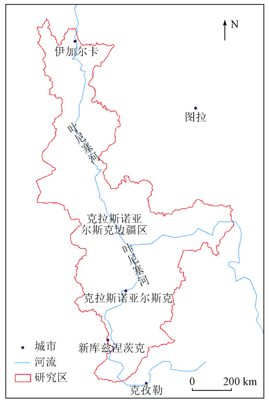
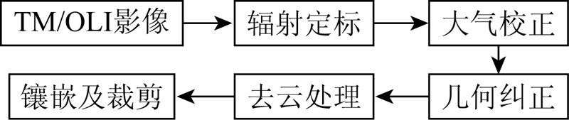
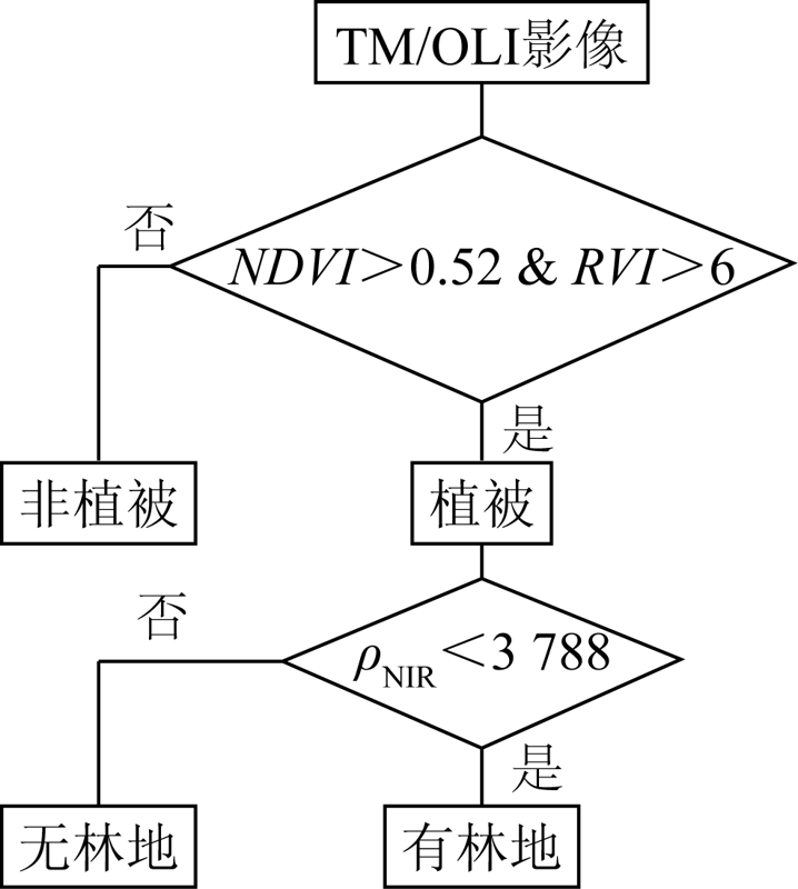
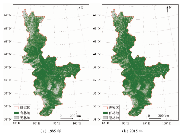
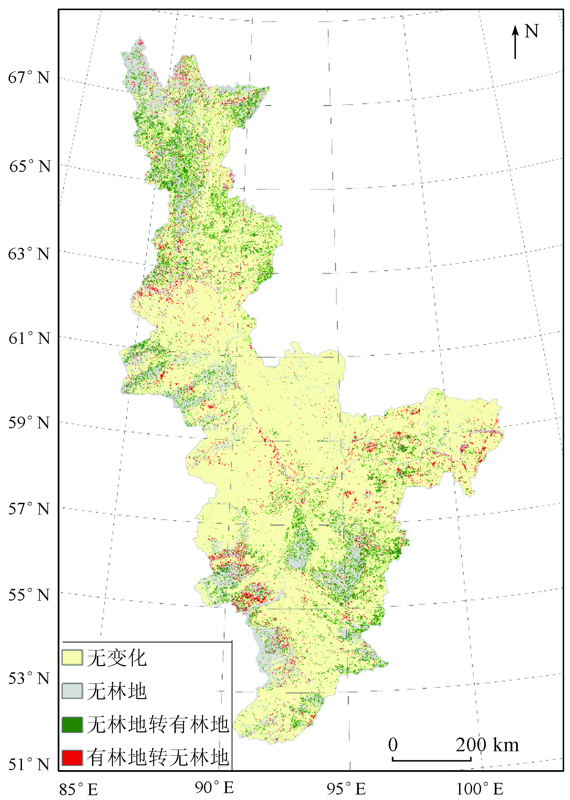
Abstract In the context of global warming, the study of the long-term spatial change characteristics of the boreal forest cover not only is important for global climate change and sustainable development research but also can provide the support for the further research on the response of the boreal forest changes to climate change. The data sources were Landsat TM/OLI images with 2 temporal series in summer season from 1985 and 2015, respectively. The Krasnoyarsk region in Russia was selected as the typical research area of the boreal forest in Siberia. The forest cover in 1985 and 2015 was classified based on the decision tree method and verification with random sample points of GF-2 satellite images, and the classification accuracy was 94.53%. The information of the dynamic spatial distribution of forest cover was quantified through latitude zones with 2° interval in the range of N51°~69° and the spatial overlay analysis for the dynamic forest cover maps of the two periods. The results show that, in the past 30 years, the boreal forest cover in Siberia changed significantly, and the overall forest cover changed from 75.42% in 1985 to 80.53% in 2015, increasing by 5.11 percentage points. Simultaneously, the changes of forest land area were different with each latitude zones: the highest change rate occurred in the latitude zone N65°~67°, followed by the latitude zone N67°~69° and the lowest was in N57°~59°. Overall, the forest cover increased in all latitude zones, the most significant increase was in N63°~67°; the change of forest cover was relatively stable in N57°~63° and the increase of forest cover decreased with the latitude zone in N51°~57°.
|
| Keywords
TM images
boreal forest
forest coverage
Siberia
spatial change
|
|
|
|
Corresponding Authors:
FU Wenxue
E-mail: richard_dada@outlook.com;fuwx@aircas.ac.cn
|
|
Issue Date: 18 March 2021
|
|
|
| [1] |
Edenhofer O, Madruga P R, Sokona Y, et al. Intergovernmental panel on climate change[C]// Climate change 2014:Mitigation of climate change.Contribution of Working Group III to the Fifth Assessment Report of the Intergovernmental Panel on Climate Change. New York: Cambridge University Press, 2014.
|
| [2] |
Food and Agriculture Organization of the United Nations. Global forest resources assessment 2015:How are the world’s forests changing[M]. Rome:Food and Agriculture Organization of the United Nations, 2015.
|
| [3] |
Corinne L Q, Andrew R M, Canadell J G, et al. Global carbon budget 2016[J]. Earth System Science Data, 2016,7(1):47-85.
|
| [4] |
Grassi G, House J, Dentener F, et al. The key role of forests in meeting climate targets requires science for credible mitigation[J]. Nature Climate Change, 2017,7(3):220-226.
|
| [5] |
Pan Y, Birdsey R A, Fang J. A large and persistent carbon sink in the world’s forests[J]. Science, 2011,333:988-993.
doi: 10.1126/science.1201609
pmid: 21764754
url: https://www.ncbi.nlm.nih.gov/pubmed/21764754
|
| [6] |
李剑泉, 李智勇, 易浩若. 森林与全球气候变化的关系[J]. 西北林学院学报, 2010,25(4):23-28.
|
| [6] |
Li J Q, Li Z Y, Yi H R. Interaetion relation between forestand global climate change[J]. Journal of Northwest Forestry University, 2010,25(4):23-28.
|
| [7] |
Stocks B J, Lynham T J. Fire weather climatology in Canada and Russia[M]. Boston:Kluwer Academic Publishers, 1996.
|
| [8] |
Larsen J A. The boreal ecosystem[M]. New York: Academic Press, 1980.
|
| [9] |
吴雪琼, 覃先林, 周汝良, 等. 森林覆盖变化遥感监测方法研究进展[J]. 林业资源管理, 2010(4):82-87.
|
| [9] |
Wu X Q, Qin X L, Zhou R L, et al. Progress of study on forest cover change detection by using remote sensing technique[J]. Forest Resources Management, 2010(4):82-87.
|
| [10] |
覃先林, 陈尔学, 李增元, 等. 基于MODIS数据的森林覆盖变化监测方法研究[J]. 遥感技术与应用, 2006,21(3):178-183.
|
| [10] |
Qin X L, Chen E X, Li Z Y, et al. Forest cover change monitoring using MODIS data[J]. Remote Sensing Technology and Application, 2006,21(3):178-183.
|
| [11] |
王荣, 江东, 韩惠, 等. 高分辨率遥感影像天然林与人工林植被覆盖信息提取[J]. 资源科学, 2013,35(4):868-874.
|
| [11] |
Wang R, Jiang D, Han H, et al. Extracting natural and artificial forest information based on high resolution remote sensing data[J]. Resources Science, 2013,35(4):868-874.
|
| [12] |
Wilson E H, Sader S A. Detection of forest harvest type using multiple dates of Landsat TM imagery[J]. Remote Sensing of Environment, 2002,80(3):385-396.
|
| [13] |
任冲, 鞠洪波, 张怀清, 等. 天水市近30年林地动态变化遥感监测研究[J]. 林业科学研究, 2017,30(1):25-33.
|
| [13] |
Ren C, Ju H B, Zhang H Q, et al. Research on remote sensing monitoring technology of forest land dynamic change in Tianshui in recent 30 years[J]. Forest Research, 2017,30(1):25-33.
|
| [14] |
姜洋, 李艳. 浙江省森林信息提取及其变化的空间分布[J]. 生态学报, 2014,34(24):7261-7270.
|
| [14] |
Jiang Y, Li Y. The extraction of forest information and the spatial distribution of its change in Zhejiang Province[J]. Acta Ecologica Sinica, 2014,34(24):7261-7270.
|
| [15] |
Serreze M C, Walsh J E, Chapin F S, et al. Observational evidence of recent change in the northern high-latitude environment[J]. Climatic Change, 2000,46(1-2):159-207.
|
| [16] |
Stocker T F, Qin D, Plattner G K, et al. Climate change:The physical science basis[M]. Cambridge: Cambridge University Press, 2013.
|
| [17] |
李存军, 刘良云, 王纪华, 等. 基于Landsat影像自身特征的薄云自动探测与去除[J]. 浙江大学学报(工学版), 2006,40(1):10-13.
|
| [17] |
Li C J, Liu L Y, Wang J H, et al. Automatic detection and removal of thin haze based on own features of Landsat image[J]. Journal of Zhejiang University(Engineering Science), 2006,40(1):10-13.
url: http://www.journals.zju.edu.cn/eng//CN/abstract/abstract9433.shtml
|
| [18] |
李德仁, 王树良, 李德毅, 等. 论空间数据挖掘和知识发现的理论与方法[J]. 武汉大学学报(信息科学版), 2002,27(3):221-233.
|
| [18] |
Li D R, Wang S L, Li D Y, et al. Theories and technologies of spatial data mining and knowledge discovery[J]. Geomatics and Information Science of Wuhan University, 2002,27(3):221-223.
|
| [19] |
胡德勇, 邓磊, 林文鹏. 遥感图像处理原理和方法[M]. 北京: 测绘出版社, 2014.
|
| [19] |
Hu D Y, Deng L, Lin W P. Principle and methods of remote sensing image processing[M]. Beijing: Surveying and Mapping Publishing House, 2014.
|
| [20] |
刘淼, 胡远满, 布仁仓, 等. 基于RS和GIS的松潘县景观变化研究[J]. 辽宁工程技术大学学报, 2007,26(3):351-353.
|
| [20] |
Liu M, Hu Y M, Bu R C, et al. Study on landscape change based on RS and GIS in Songpan County[J]. Journal of Liaoning Technical University, 2007,26(3):351-353.
|
| [21] |
Myneni R, Keeling C, Tucker C, et al. Increased plant growth in the northern high latitudes from 1981 to 1991[J]. Nature, 1997,386:698-702.
|
| [22] |
Keeling C, Chin J, Whorf T. Increased activity of northern vegetation inferred from atmospheric CO2 measurements[J]. Nature, 1996,382(6587):146-149.
|
| [23] |
尹凌宇, 覃先林, 孙桂芬, 等. 利用KPCA法检测高分一号影像中的森林覆盖变化[J]. 国土资源遥感, 2018,30(1):95-101.doi: 10.6046/gtzyyg.2018.01.13.
|
| [23] |
Yi L Y, Qin X L, Sun G F, et al. The method for detecting forest cover change in GF-1 images by using KPCA[J]. Remote Sensing for Land and Resources, 2018,30(1):95-101.doi: 10.6046/gtzyyg.2018.01.13.
|
|
Viewed |
|
|
|
Full text
|
|
|
|
|
Abstract
|
|
|
|
|
Cited |
|
|
|
|
| |
Shared |
|
|
|
|
| |
Discussed |
|
|
|
|
 2021,
Vol. 33
2021,
Vol. 33