|
|
|
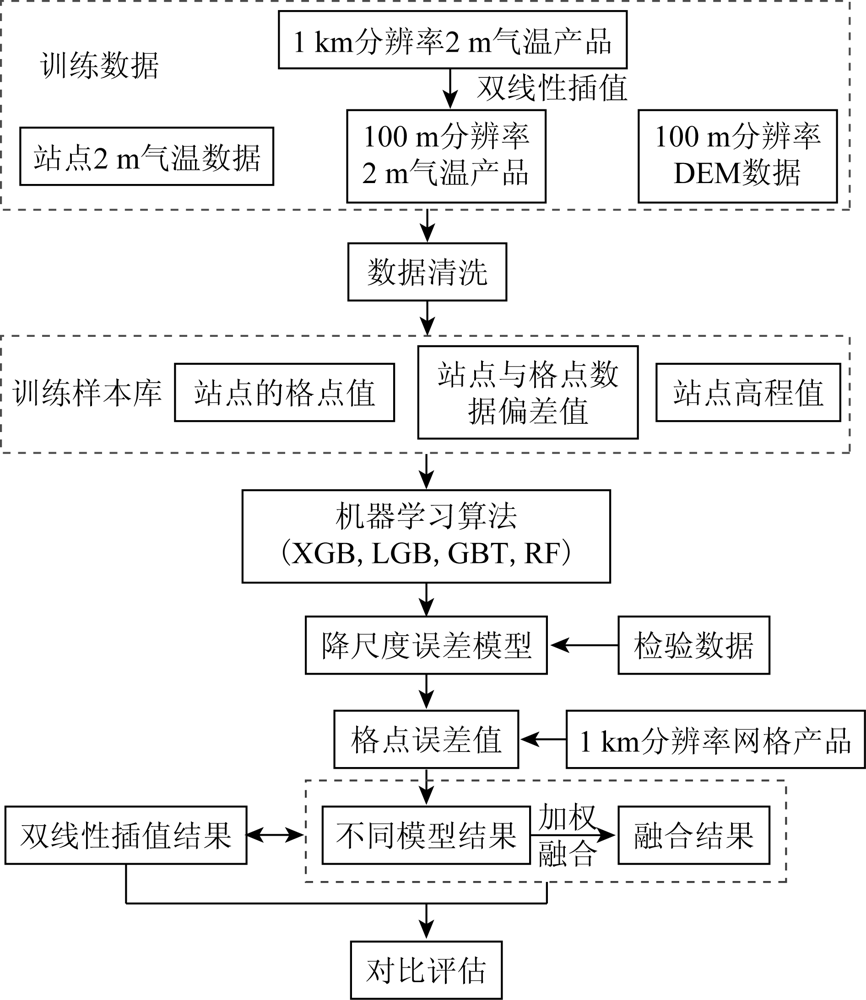
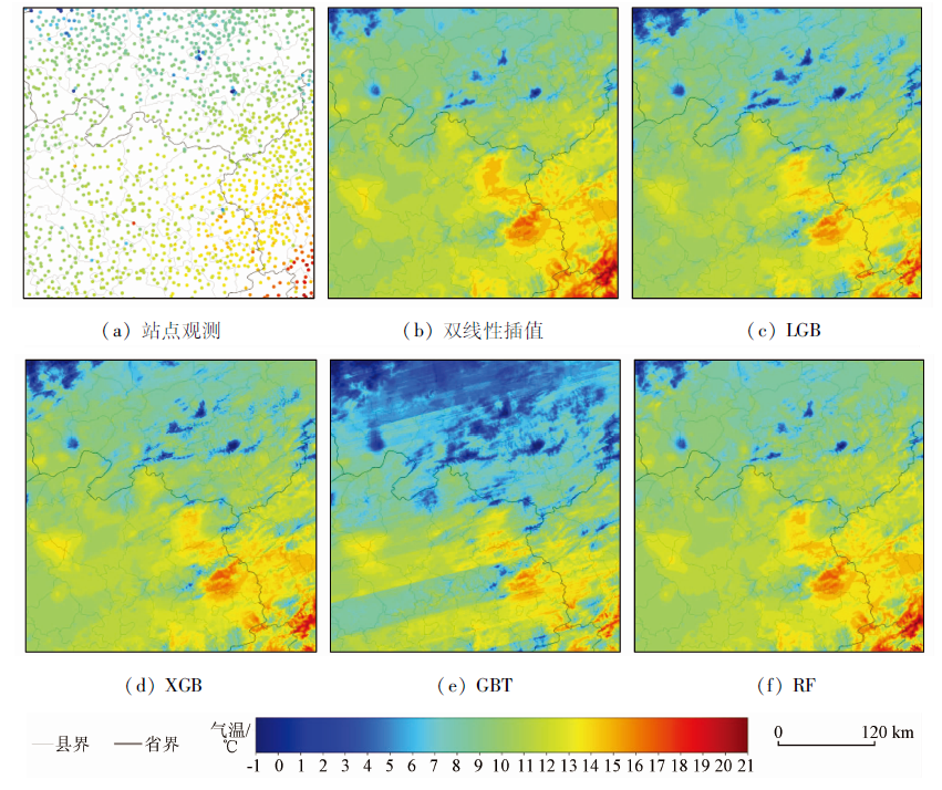
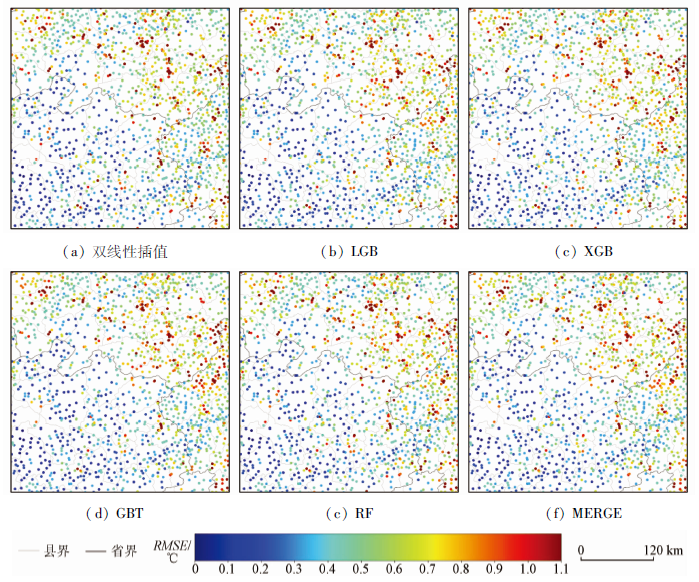
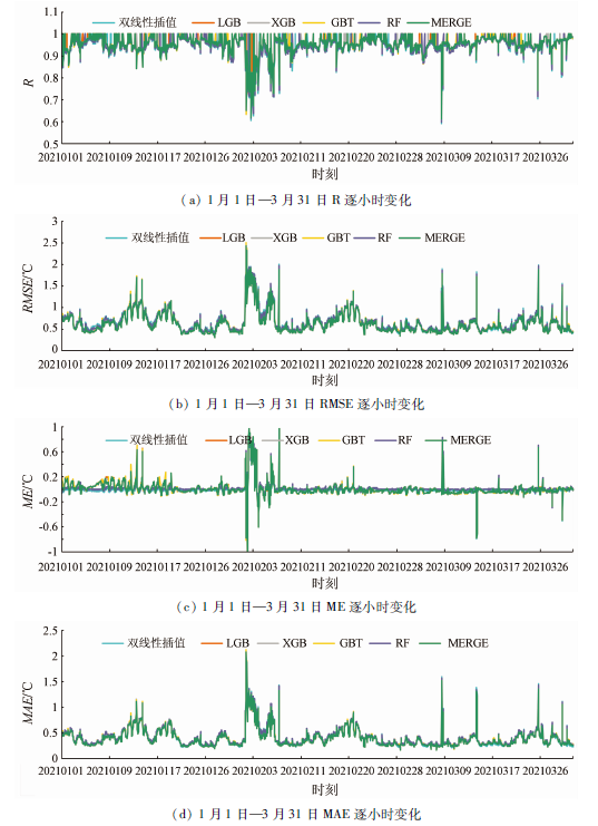
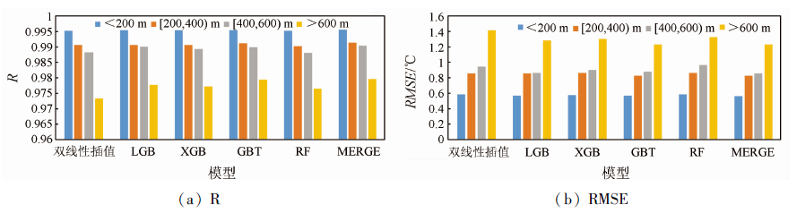
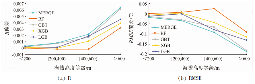
Abstract High-resolution meteorological data serve as an important data basis for fine-scale meteorological services. Using the hourly 2-meter air temperature grid data from January 2020 to March 2021 and the terrain factors such as altitude, longitude, and latitude, this study aimed to enhance the resolution of 2-meter air temperature grid data with a resolution of 1 km to 100 m through downscaling based on four machine learning methods, namely LightGBM (LGB), XGBoost (XGB), gradient boosting tree (GBT), and random forest (RF). Then, this study conducted the weighted fusion of downscaling results of different models. Finally, the downscaling results of different models were compared with the bilinear interpolation results, and the results are as follows. The results of each downscaling model were relatively consistent with the observational data. Compared with the bilinear interpolation results, the results of the LGB, XGB, and RF models had similar spatial structures but were more detailed. All downscaling models yielded the same spatio-temporal distribution characteristics of errors. Compared with the bilinear interpolation results, the data of the LGB, XGB, and GBT models showed significantly higher precision, and their root mean square errors (RMSEs) decreased by 5.2%, 4.1%, and 4.6%, respectively. Meanwhile, the RMSE after weighted fusion decreased by 5.9%, which was higher than that of any single machine learning model. The downscaling results of the LGB, XGB, and GBT models were improved to a certain degree compared with the bilinear interpolation results under different terrain conditions, especially in high-altitude areas (above 600 m). The correlation coefficients of results of the LGB, XGB, and BGT models and model based on weighted fusion increased by 0.45%, 0.40%, 0.63%, and 0.66%, respectively, and their RMSEs decreased by 9.1%, 8.0%, 12.7%, and 13.1%, respectively. These results indicate that the downscaling model based on the weighted fusion of different machine learning methods can both improve spatial resolution and maintain data precision and, thus, is suitable for downscaling research on 2-meter air temperature data in the study area. This study can be used as a reference for developing high-resolution data products.
|
| Keywords
real-time grid product
2-meter air temperature
downscaling
machine learning
weighted fusion
|
|
|
|
Issue Date: 20 March 2023
|
|
|
| [1] |
李显风, 张玮, 李芬, 等. 基于WebGIS的实况网格产品应用分析平台及关键技术[J]. 气象科技, 2020, 48(2):185-194.
|
| [1] |
Li X F, Zhang W, Li F, et al. An WebGIS-based real-time application/analysis platform of grid products and key technology[J]. Meteorological Science and Technology, 2020, 48(2):185-194.
|
| [2] |
张玮, 李显风, 何瑶, 等. 基于江西省站点资料对智能网格实况分析产品的检验评估[J]. 江西师范大学学报(自然科学版), 2020, 44(4):403-410.
|
| [2] |
Zhang W, Li X F, He Y, et al. The quality assessment of the intelligent grid real-time analysis products using the station data in Jiangxi Province[J]. Journal of Jiangxi Normal University (Nature Science), 2020, 44(4):403-410.
|
| [3] |
韩帅, 师春香, 姜志伟, 等. CMA高分辨率陆面数据同化系统(HRCLDAS-V1.0)研发及进展[J]. 气象科技进展, 2018, 8(1):102-108.
|
| [3] |
Han S, Shi C X, Jiang Z W, et al. Development and progress of high resolution CMA land surface data assimilation system[J]. Advances in Meteorological Science and Technology, 2018, 8(1):102-108.
|
| [4] |
潘旸, 谷军霞, 徐宾, 等. 多源降水数据融合研究及应用进展[J]. 气象科技进展, 2018, 8(1):143-152.
|
| [4] |
Pan Y, Gu J X, Xu B, et al. Advances in multi-source precipitation merging research[J]. Advances in Meteorological Science and Technology, 2018, 8(1):143-152.
|
| [5] |
师春香, 潘旸, 谷军霞, 等. 多源气象数据融合格点实况产品研制进展[J]. 气象学报, 2019, 77(4):774-783.
|
| [5] |
Shi C X, Pan Y, Gu J X, et al. A review of multi-source meteorological data fusion products[J]. Acta Meteorologica Sinica, 2019, 77(4):774-783.
|
| [6] |
李显风, 张玮, 黄少平, 等. 江西省气象-水文-雷达小时雨量信息融合试验结果分析[J]. 暴雨灾害, 2020, 39(3):276-284.
|
| [6] |
Li X F, Zhang W, Huang S P, et al. Analysis of fusion test results on hourly precipitation from meteorological and hydrological stations and Radar[J]. Torrential Rain and Disasters, 2020, 39(3):276-284.
|
| [7] |
Kustas W P, Norman J M, Anderson M C, et al. Estimating subpixel surface temperatures and energy fluxes from the vegetation index-radiometric temperature relationship[J]. Remote Sensing of Environment, 2003, 85(4):429-440.
doi: 10.1016/S0034-4257(03)00036-1
url: https://linkinghub.elsevier.com/retrieve/pii/S0034425703000361
|
| [8 ] |
Agam N, Kustas W P, Anderson M C, et al. A vegetation index based technique for spatial sharpening of thermal imagery[J]. Remote Sensing of Environment, 2007, 107(4):545-558.
doi: 10.1016/j.rse.2006.10.006
url: https://linkinghub.elsevier.com/retrieve/pii/S0034425706003671
|
| [9] |
张晓. 天山中段卫星降水数据的降尺度研究及时空特征分析[D]. 兰州: 西北师范大学, 2013.
|
| [9] |
Zhang X. Study on the downscaling algorithm of remote sensing precipitation and analysis of temporal-spatial characteristic in the middle section of Mount Tianshan[D]. Lanzhou: Northwest Normal University, 2013.
|
| [10] |
Duan S B, Li Z L. Spatial downscaling of MODIS land surface temperatures using geographically weighted regression:Case study in northern China[J]. IEEE Transactions on Geoscience and Remote Sensing, 2016, 54(11):6458-6469.
doi: 10.1109/TGRS.2016.2585198
url: http://ieeexplore.ieee.org/document/7517288/
|
| [11] |
Yang G J, Pu R L, Huang W J, et al. A novel method to estimate subpixel temperature by fusing solar-reflec-tive and thermal-infrared remote-sensing data with an artificial neural network[J]. IEEE Transactions on Geoscience and Remote Sensing, 2010, 48(4):2170-2178.
doi: 10.1109/TGRS.2009.2033180
url: http://ieeexplore.ieee.org/document/5325792/
|
| [12] |
Hutengs C, Vohland M. Downscaling land surface temperatures at regional scales with random forest regression[J]. Remote Sensing of Environment, 2016, 178:127-141.
doi: 10.1016/j.rse.2016.03.006
url: https://linkinghub.elsevier.com/retrieve/pii/S0034425716300992
|
| [13] |
颜佳楠, 陈虹, 姚光林, 等. 基于XGBoost的LST空间降尺度方法[J]. 无线电工程, 2021, 51(12):1508-1516.
|
| [13] |
Yan J N, Chen H, Yao G L, et al. A spatial downscaling method of land surface temperature based on XGBoost algorithm[J]. Radion Engineering, 2021, 51(12):1508-1516.
|
| [14] |
尹枷愿, 蔡宏, 田鹏举, 等. 喀斯特地区地表温度空间降尺度方法初探[J]. 地理与地理信息科学, 2021, 27(3):38-46.
|
| [14] |
Yin J Y, Cai H, Tian P J, et al. Spatial downscaling research of the land surface temperature in karst region[J]. Geography and Geo-Information Science, 2021, 27(3):38-46.
|
| [15] |
徐彬仁, 魏瑗瑗. 基于随机森林算法对青藏高原TRMM降水数据进行空间统计降尺度研究[J]. 国土资源遥感, 2018, 30(3):181-188.doi:10.6046/gtzyyg.2018.03.25.
doi: 10.6046/gtzyyg.2018.03.25
|
| [15] |
Xu B R, Wei Y Y. Spatial statistics of TRMM precipitation in the Tibetan Plateau using random forest algorithm[J]. Remote Sensing for Land and Resources, 2018, 30(3):181-188.doi:10.6046/gtzyyg.2018.03.25.
doi: 10.6046/gtzyyg.2018.03.25
|
| [16] |
张朝忙, 刘庆生, 刘高焕, 等. STRM3与ASTER GDEM数据处理及应用进展[J]. 地理与地理信息科学, 2012, 28(5):29-34.
|
| [16] |
Zhang C M, Liu Q S, Liu G H, et al. Data processing and application progress of SRTM3 and ASTER GDEM[J]. Geography and Geo-Information Science, 2012, 28(5):29-34.
|
| [17] |
康俊锋, 黄烈星, 张春艳, 等. 多机器学习模型下逐小时PM2.5预测及对比分析[J]. 中国环境科学, 2020, 40(5):1895-1905.
|
| [17] |
Kang J F, Huang L X, Zhang C Y, et al. Hourly PM2.5 prediction and comparative analysis under multi-machine learning model[J]. China Environment Science, 2020, 40(5):1895-1905.
|
| [18] |
胡占占, 陈传法, 胡保健. 基于时空XGBoost的中国区域PM2.5浓度遥感反演[J]. 环境科学学报, 2021, 41(10):4228-4237.
|
| [18] |
Hu Z Z, Chen C F, Hu B J. Estimating PM2.5 concentrations across China based on space-time XGBoost approach[J]. Acta Scientiae Circumstan tiae, 2021, 41(10):4228-4237.
|
| [19] |
余东昌, 赵文芳, 聂凯, 等. 基于LightGBM算法的能见度预测模型[J]. 计算机应用, 2021, 41(4):1035-1041.
doi: 10.11772/j.issn.1001-9081.2020081589
|
| [19] |
Yu D C, Zhao W F, Nie K, et al. Visibility forecast model based on LightGBM algorithm[J]. Journal of Computer Application, 2021, 41(4):1035-1041.
|
|
Viewed |
|
|
|
Full text
|
|
|
|
|
Abstract
|
|
|
|
|
Cited |
|
|
|
|
| |
Shared |
|
|
|
|
| |
Discussed |
|
|
|
|
 2023,
Vol. 35
2023,
Vol. 35
 ), YUAN Zhengguo(