|
|
|
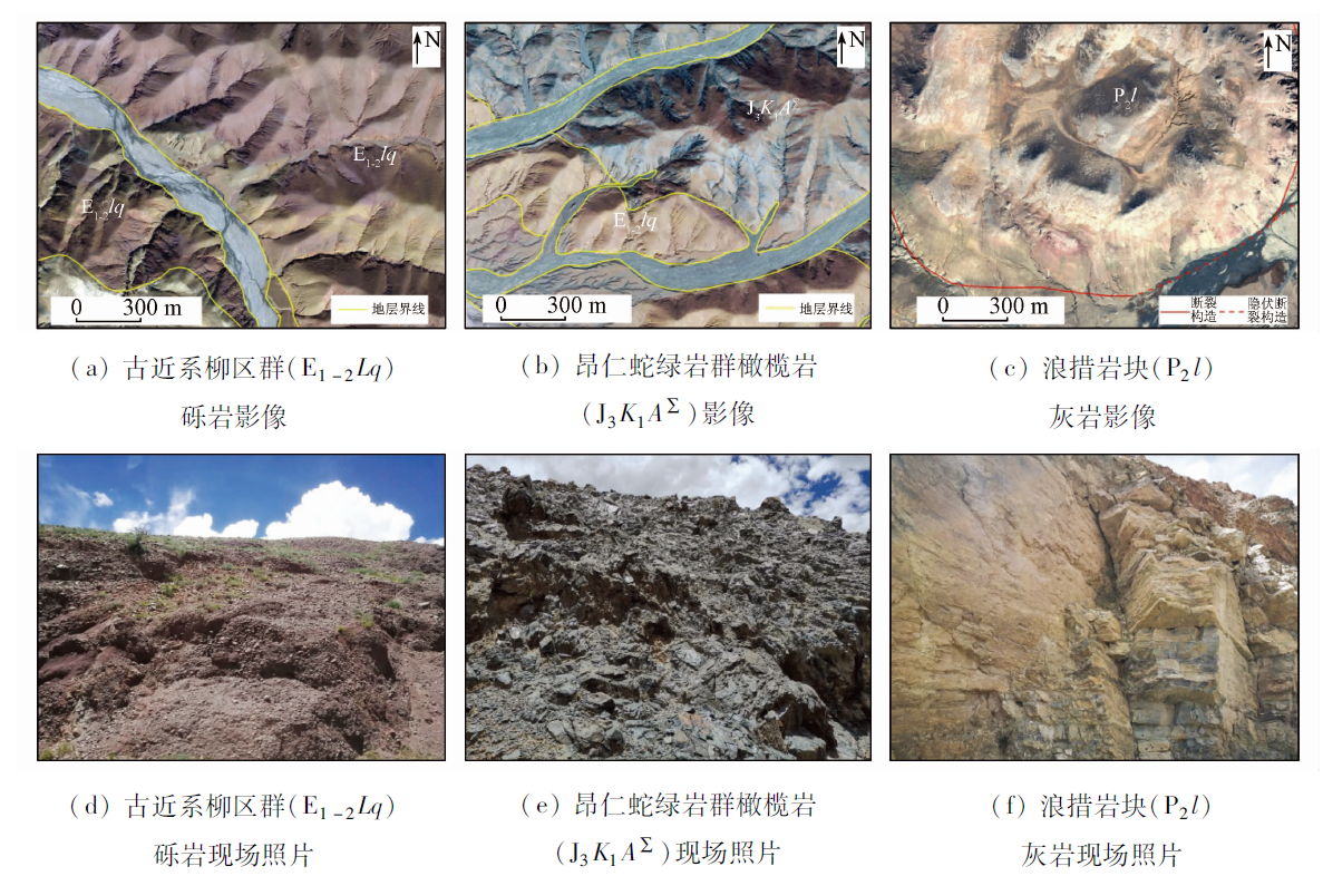
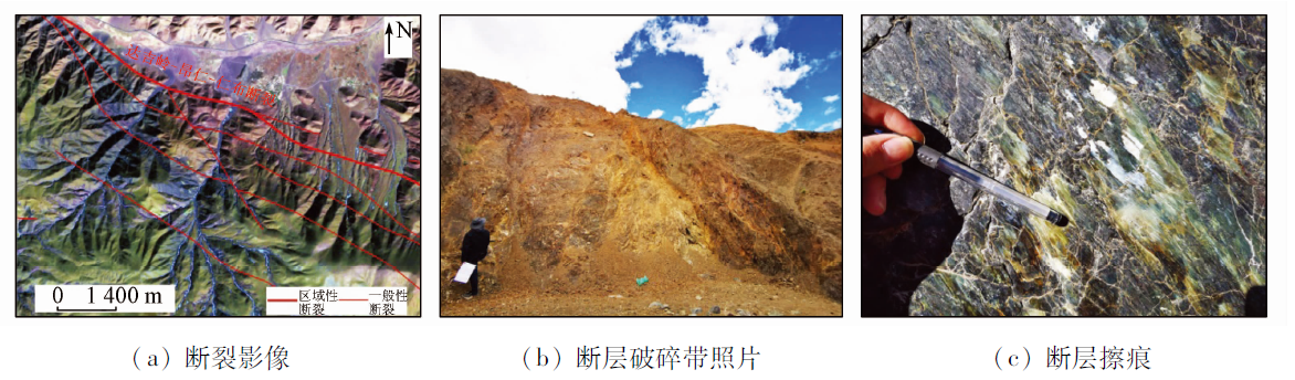
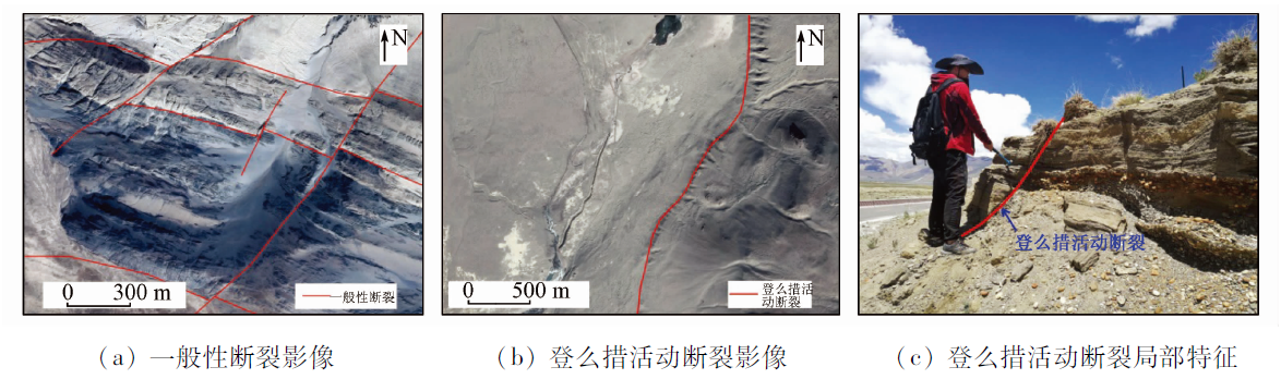
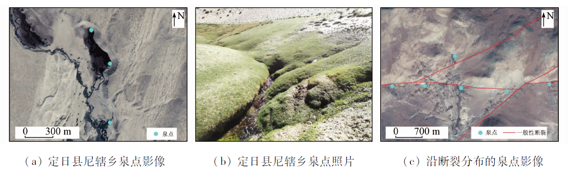
Abstract As the first railway project crossing the Himalayas in the world, the construction of the China-Nepal railway is confronted with many environmental and geological problems such as high elevation, a big difference in elevation, alpine climate, seismic activity zones, soft-rock deformation, and geological disasters. Since the design and selection of route schemes of the railway line are notably restricted by geological conditions, it is necessary to thoroughly understand various geological problems in the study area. This study gives full play to the remote sensing technique to overcome the limitations of surface surveys, reduce the workload of field surveys, and improve work efficiency. Based on the analyses of existing data on basic geology, engineering geology, and geological environment, this study uses the multi-source remote sensing technique to conduct a detailed interpretation and analysis of the adverse geological elements in the study area, including terrain, landform, stratigraphic lithology, geological structures, hydrogeology, landslides, debris flow, and wind-blown sand. In this way, it provides detailed, comprehensive, and reliable remote sensing data for the engineering geological survey and the route design and selection of the China-Nepal railway and plays an important role in technical support.
|
| Keywords
China-Nepal railway
geological interpretation
engineering geology
landslide
debris flow
|
|
|
|
Corresponding Authors:
LIU Yalin
E-mail: cfq531992@126.com;lynn6100@126.com
|
|
Issue Date: 23 December 2021
|
|
|
| [1] |
童立强, 聂洪峰, 李建存, 等. 喜马拉雅山地区大型泥石流遥感调查与发育特征研究[J]. 国土资源遥感, 2013,25(4):104-112.doi: 10.6046/gtzyyg.2013.04.17.
doi: 10.6046/gtzyyg.2013.04.17
|
| [1] |
Tong L Q, Nie H F, Li J C, et al. Survey of large-scale debris flow and study of its development characteristics using remote sensing technology in the Himalayas[J]. Remote Sensing for Land and Resources, 2013,25(4):104-112.doi: 10.6046/gtzyyg.2013.04.17.
doi: 10.6046/gtzyyg.2013.04.17
|
| [2] |
刘桂卫, 郭晓亮. 遥感技术在浦梅线地质勘察中应用研究[J]. 铁道工程学报, 2016,33(12):9-13,23.
|
| [2] |
Liu G W, Guo X L. Application of remote sensing technology for geological investigation in Pucheng-Meizhou Railway[J]. Journal of Railway Engineering Society, 2016,33(12):9-13,23.
|
| [3] |
陈富强, 邓国仕, 姬星怡, 等. 遥感技术在川西螺髻山地区水文地质环境调查中的应用[J]. 国土资源遥感, 2019,31(4):209-217.doi: 10.6046/gtzyyg.2019.04.27.
doi: 10.6046/gtzyyg.2019.04.27
|
| [3] |
Chen F Q, Deng G S, Ji X Y, et al. Application of remote sensing technology to hydrogeological environment survey in the Luoji Mountain area,western Sichuan Province[J]. Remote Sensing for Land and Resources, 2019,31(4):209-217.doi: 10.6046/gtzyyg.2019.04.27.
doi: 10.6046/gtzyyg.2019.04.27
|
| [4] |
余绍淮, 陈楚江, 张霄. 基于遥感技术的中吉乌铁路地质构造分析[J]. 铁道工程学报, 2015,32(5):12-17.
|
| [4] |
Yu S H, Chen C J, Zhang X. Analysis of the geological structure for China-Kyrgyzstan-Uzbekistan Railway based on remote sensing[J]. Journal of Railway Engineering Society, 2015,32(5):12-17.
|
| [5] |
李晓民, 张焜, 李冬玲, 等. 青藏高原札达地区多年冻土遥感技术圈定方法与应用[J]. 国土资源遥感, 2017,29(1):57-64.doi: 10.6046/gtzyyg.2017.01.09.
doi: 10.6046/gtzyyg.2017.01.09
|
| [5] |
Li X M, Zhang K, Li D L, et al. Remote sensing technology delineation method and its application to permafrost of Zha da area in the Tibetan Plateau[J]. Remote Sensing for Land and Resources, 2017,29(1):57-64.doi: 10.6046/gtzyyg.2017.01.09.
doi: 10.6046/gtzyyg.2017.01.09
|
| [6] |
孟祥连, 周福军. 真实感场景遥感技术在铁路工程勘察中的应用[J]. 西南交通大学学报, 2017,52(5):949-955.
|
| [6] |
Meng X L, Zhou F J. Application of railway engineering survey based on remote sensing technology for realistic scenes[J]. Journal of Southwest Jiaotong University, 2017,52(5):949-955.
|
| [7] |
刘桂卫. 多尺度三维遥感技术在某铁路地质勘察中应用[J]. 铁道工程学报, 2016,33(8):40-43,99.
|
| [7] |
Liu G W. Application of multi-scale 3D remote sensing technology for geological investigation in railway[J]. Journal of Railway Engineering Society, 2016,33(8):40-43,99.
|
| [8] |
张占忠. 铁路大场景立体影像模型制作关键技术及应用[J]. 铁道工程学报, 2020,37(4):11-16.
|
| [8] |
Zhang Z Z. Key technologies for making large scene stereo model and its application in railway survey and design[J]. Journal of Railway Engineering Society, 2020,37(4):11-16.
|
| [9] |
吕希奎, 陈进杰. 铁路数字化选线三维地质环境建模方法[J]. 铁道学报, 2015,37(8):91-97.
|
| [9] |
Lyu X K, Chen J J. Three-dimensional geological environment modeling method for digital railway alignment[J]. Journal of The China Railway Society, 2015,37(8):91-97.
|
| [10] |
孙先锋. 中尼铁路沿线活动断裂对地质选线的影响浅析[J]. 铁道标准设计, 2019,63(3):44-48.
|
| [10] |
Sun X F. An analysis of the effect of the active faults along the China-Nepal Railway on the geological route selection[J]. Railway Standard Design, 2019,63(3):44-48.
|
| [11] |
黄艺丹, 姚令侃, 谭礼, 等. 喜马拉雅造山带工程效应及中尼铁路工程地质分区[J]. 工程地质学报, 2020,28(2):421-430.
|
| [11] |
Huang Y D, Yao L K, Tan L, et al. Engineering effect of the Himalayan orogen and engineering geological zoning of China-Nepal Railway[J]. Journal of Engineering Geology, 2020,28(2):421-430.
|
| [12] |
潘桂棠, 肖庆辉, 陆松年 等. 中国大地构造单元划分[J]. 中国地质, 2009,36(1):1-16,255,17-28.
|
| [12] |
Pan G T, Xiao Q H, Lu S N, et al. Subdivision of tectonic units in China[J]. Geology in China, 2009,36(1):1-16,255,17-28.
|
| [13] |
马建军, 潘美慧, 伍永秋, 等. 1996—2016年西藏定结地区风沙地貌格局与变化[J]. 干旱区地理, 2018,41(5):1035-1042.
|
| [13] |
Ma J J, Pan M H, Wu Y Q, et al. Geomorphological pattern and its change of aeolian landform in Dingjie area of Tibet from 1996 to 2016[J]. Arid Land Geography, 2018,41(5):1035-1042.
|
|
Viewed |
|
|
|
Full text
|
|
|
|
|
Abstract
|
|
|
|
|
Cited |
|
|
|
|
| |
Shared |
|
|
|
|
| |
Discussed |
|
|
|
|
 2021,
Vol. 33
2021,
Vol. 33
 ), LIU Yalin(