|
|
|
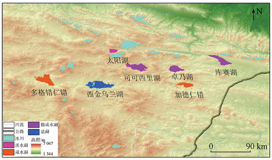
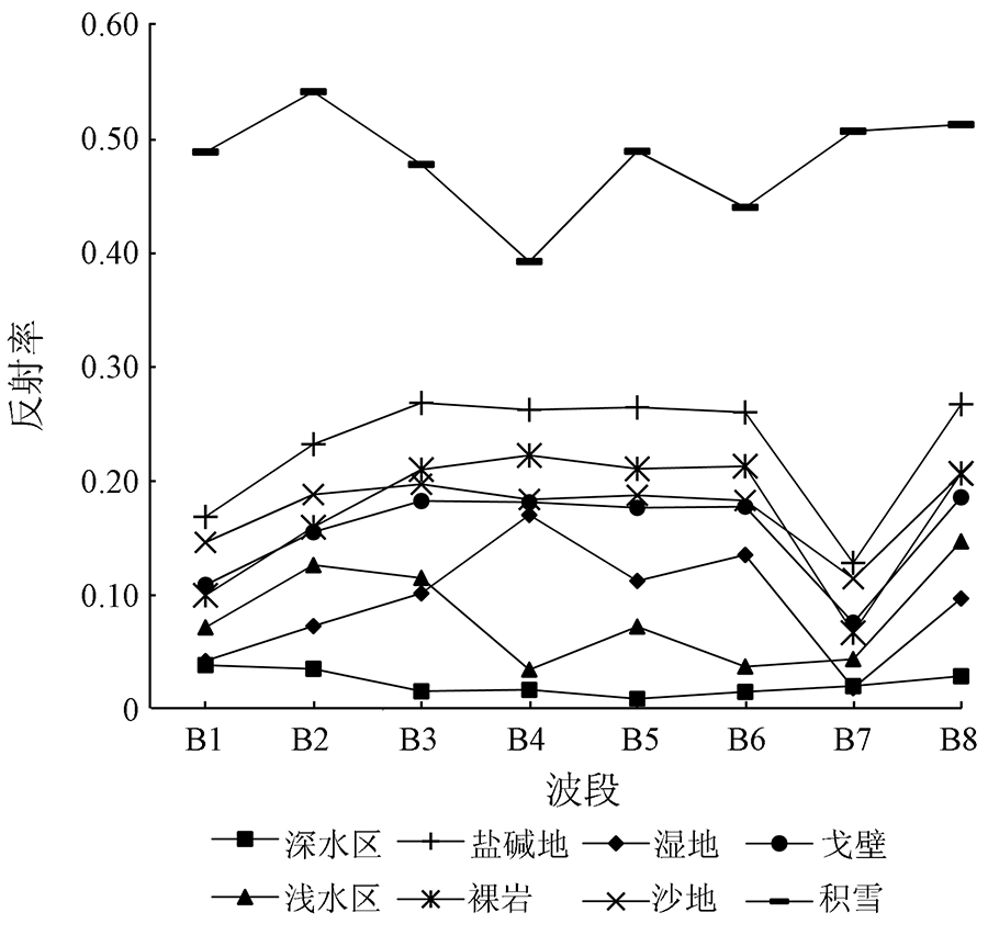
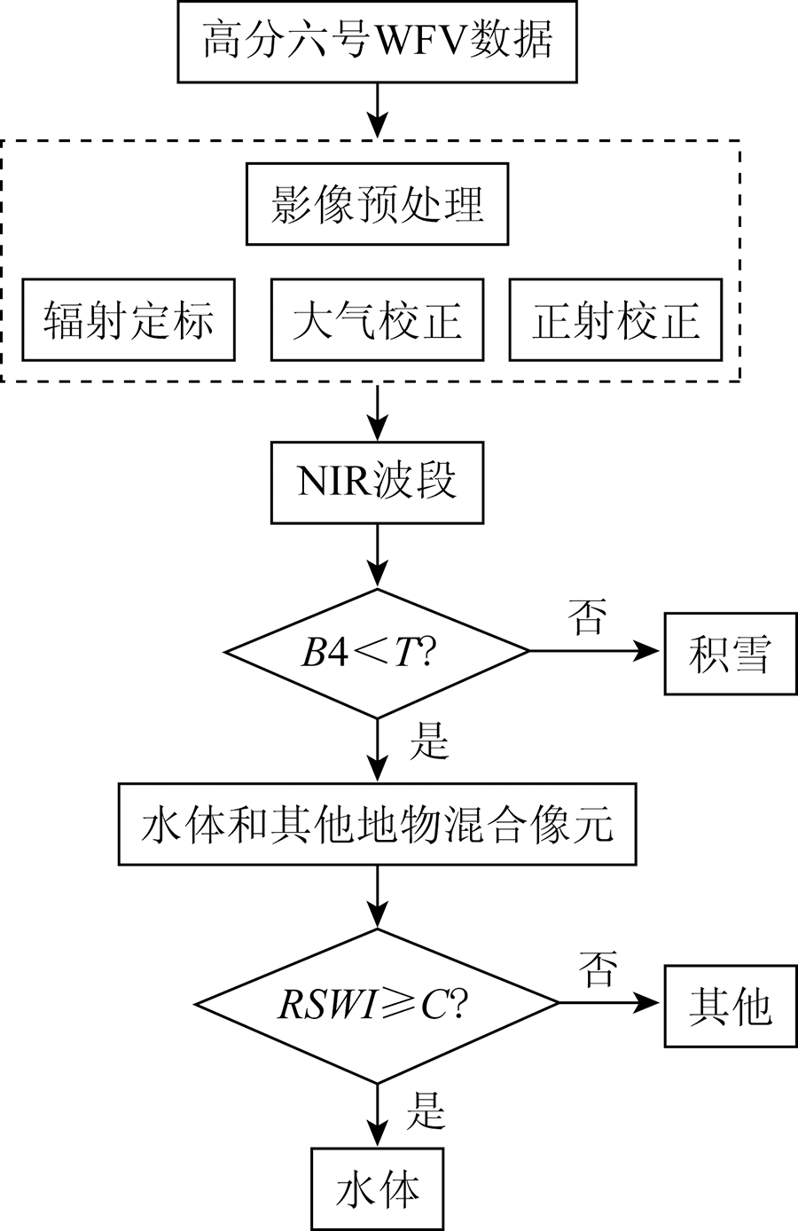
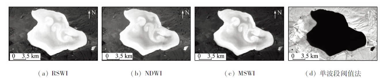
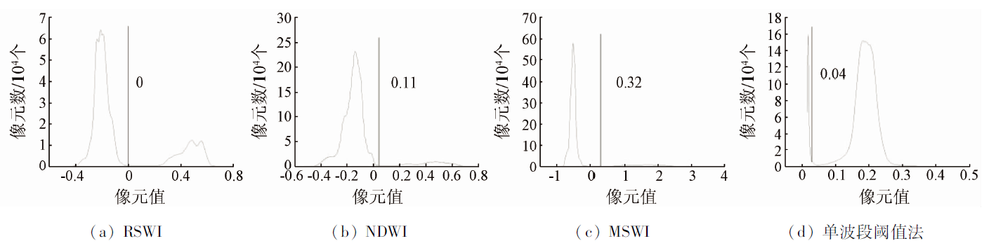
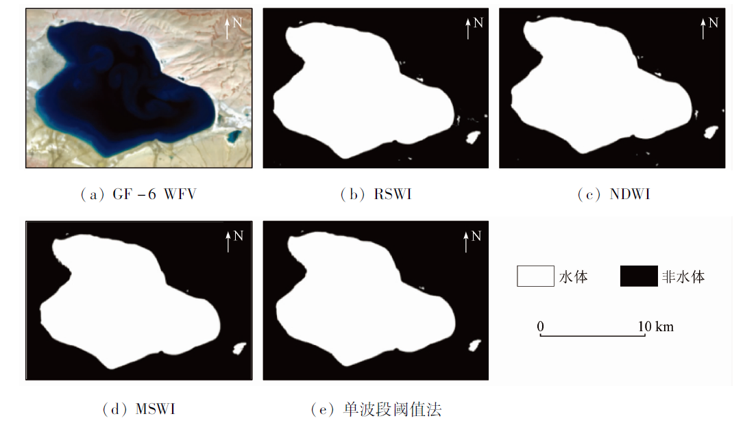
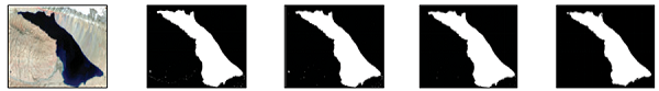
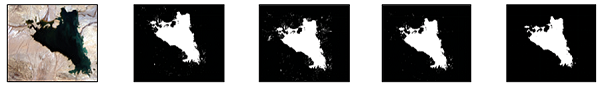
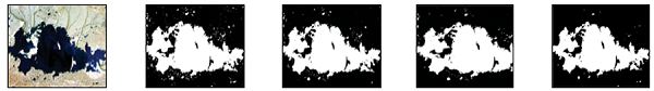
Abstract Exploration of the water body extraction model based on GF-6 satellite images can provide new data sources and technical support for water body monitoring. First, GF-6 WFV satellite data of Zonag Lake was used to analyze the reflectance difference between water and other ground objects in each band of GF-6 WFV satellite data. Based on this, a novel water index named red side water index (RSWI) was constructed. Then, the overall accuracy and Kappa coefficient generated by the confusion matrix were used to verify RSWI and the other three water extraction models, which include the single-band threshold method, normalized difference water index, and modified shade water index. Finally, six typical lakes with different types of areas larger than 100 km2 in Hoh Xil were selected for analysis of general applicability. The results showed that compared with other methods, the decision tree model composed of RSWI and NIR bands effectively eliminates the influence of lake bottom sediments on water bodies and extracts shallow water bodies more completely, with an overall accuracy of 93.78% and a Kappa coefficient of 0.87. Additionally, it has been found that the stability and general applicability of RSWI are better than those of other water body models with respect to different types of lakes.
|
| Keywords
GF-6
lakes in Hoh Xil
water body identification model
read side water index
|
|
|
|
Corresponding Authors:
LIU Baokang
E-mail: wrj_2021@163.com;liubk04@qq.com
|
|
Issue Date: 20 June 2022
|
|
|
| [1] |
徐蓉, 张增祥, 赵春哲. 湖泊水体遥感提取方法比较研究[J]. 遥感信息, 2015, 30(1):111-118.
|
| [1] |
Xu R, Zhang Z X, Zhao C Z. Different models used in extraction of lake water body based on MODIS data[J]. Remote Sensing Information, 2015, 30(1):111-118.
|
| [2] |
朱刚, 高会军, 曾光. 近35 a来新疆干旱区湖泊变化及原因分析[J]. 干旱区地理, 2015, 38(1):103-110.
|
| [2] |
Zhu G, Gao H J, Zeng G. Lake change research and reasons analysis in Xinjiang arid regions during the past 35 years[J]. Arid Land Geography, 2015, 38(1):103-110.
|
| [3] |
谢昌卫, 张钰鑫, 刘文惠, 等. 可可西里卓乃湖溃决后湖区环境变化及盐湖可能的溃决方式[J]. 冰川冻土, 2020, 42(4):1344-1352.
doi: 10.7522/j.issn.1000-0240.2019.0051
|
| [3] |
Xie C W, Zhang Y X, Liu W H, et al. Environmental changes caused by the outburst of Zonag Lake and the possible outburst mode of Yanhu Lake in the Hoh Xil region[J]. Journal of Glaciology and Geocryology, 2020, 42(4):1344-1352.
|
| [4] |
拉巴, 格桑卓玛, 拉巴卓玛, 等. 1992—2014年普若岗日冰川和流域湖泊面积变化及原因分析[J]. 干旱区地理, 2016, 39(4):770-776.
|
| [4] |
La B, Ge S Z M, La B Z M, et al. Variation and reasons of the coverage of Puruogangri glacier and its surrounding lakes during 1992—2014[J]. Arid Land Geography, 2016, 39(4):770-776.
|
| [5] |
姚晓军, 刘时银, 李龙, 等. 近40年可可西里地区湖泊时空变化特征[J]. 地理学报, 2013, 68(7):886-896.
|
| [5] |
Yao X J, Liu S Y, Li L, et al. Spatial temporal variations of lake area in Hoh Xil region in the past 40 years[J]. Acta Geographica Sinica, 2013, 68(7):886-896.
|
| [6] |
姚晓军, 孙美平, 宫鹏, 等. 可可西里盐湖湖水外溢可能性初探[J]. 地理学报, 2016, 71(9):1520-1527.
doi: 10.11821/dlxb201609005
|
| [6] |
Yao X J, Sun M P, Gong P, et al. Overflow probability of the salt lake in Hoh Xil region[J]. Acta Geographica Sinica, 2016, 71(9):1520-1527.
|
| [7] |
刘宝康, 李林, 杜玉娥, 等. 青藏高原可可西里卓乃湖溃堤成因及其影响分析[J]. 冰川冻土, 2016, 38(2):305-311.
|
| [7] |
Liu B K, Li L, Du Y E, et al. Causes of the outburst of Zonag Lake in Hoh Xil,Tibetan Plateau,and its impact on surrounding environment[J]. Journal of Glaciology and Geocryology, 2016, 38(2):305-311.
|
| [8] |
Komeil R, Anuar A, Ail S, et al. Water feature extraction and change detection using multitemporal Landsat imagery[J]. Remote Sensing, 2014, 6(5):4173-4189.
doi: 10.3390/rs6054173
url: http://www.mdpi.com/2072-4292/6/5/4173
|
| [9] |
Adrian F, Neil F, Tim D. Comparing Landsat water index methods for automated water classification in eastern Australia[J]. Remote Sensing of Environment, 2016(175):167-182.
|
| [10] |
毕海芸, 王思远, 曾江源, 等. 基于TM影像的几种常用水体提取方法的比较和分析[J]. 遥感信息, 2012, 27(5):77-82.
|
| [10] |
Bi H Y, Wang S Y, Zeng J Y, et al. Comparison and analysis of several common water extraction methods based on TM image[J]. Remote Sensing Information, 2012, 27(5):77-82.
|
| [11] |
陈鹏, 张青, 李倩. 基于FY3A/MERSI影像的几种常用水体提取方法的比较分析[J]. 干旱区地理, 2015, 38(4):770-778.
|
| [11] |
Chen P, Zhang Q, Li Q. Comparative analysis of several commonly used water extraction method based on FY3A/MERSI imagery[J]. Arid Land Geography, 2015, 38(4):770-778.
|
| [12] |
杨莹, 阮仁宗. 基于TM影像的平原湖泊水体信息提取的研究[J]. 遥感信息, 2010, 25(3):60-64.
|
| [12] |
Yang Y, Ruan R Z. Extraction of plain lake water body based on TM imagery[J]. Remote Sensing Information, 2010, 25(3):60-64.
|
| [13] |
McFeeters S K. The use of the normalized difference water index( NDWI) in the delineation of open water feature[J]. International Journal of Remote Sensing, 1996, 17(7):1425-1432.
doi: 10.1080/01431169608948714
url: https://www.tandfonline.com/doi/full/10.1080/01431169608948714
|
| [14] |
徐涵秋. 利用改进的归一化差异水体指数(MNDWI)提取水体信息的研究[J]. 遥感学报, 2005, 9(5):589-595.
|
| [14] |
Xu H Q. A study on information extraction of water body with the modified normalized difference water index(MNDWI)[J]. Journal of Remote Sensing, 2005, 9(5):589-595.
|
| [15] |
陈文倩, 丁建丽, 李艳华, 等. 基于国产GF-1遥感影像的水体提取方法[J]. 资源科学, 2015, 37(6):1166-1172.
|
| [15] |
Chen W Q, Ding J L, Li Y H, et al. Extraction of water information based on China-made GF-1 remote sense image[J]. Resources Science, 2015, 37(6):1166-1172.
|
| [16] |
王瑾杰, 丁建丽, 张成, 等. 基于GF-1卫星影像的改进SWI水体提取方法[J]. 国土资源遥感, 2017, 29(1):29-35.doi: 10.6046/gtzyyg.2017.01.05.
doi: 10.6046/gtzyyg.2017.01.05
|
| [16] |
Wang J J, Ding J L, Zhang C, et al. Method of water information extraction by improved SWI based on GF-1 satellite image[J]. Remote Sensing for Land and Resources, 2017, 29(1):29-35.doi: 10.6046/gtzyyg.2017.01.05.
doi: 10.6046/gtzyyg.2017.01.05
|
| [17] |
王小标, 谢顺平, 都金康. 水体指数构建及其在复杂环境下有效性研究[J]. 遥感学报, 2018, 22(2):360-372.
|
| [17] |
Wang X B, Xie S P, Du J K. Water index formulation and its effectiveness research on the complicated surface water surroundings[J]. Journal of Remote Sensing, 2018, 22(2):360-372.
|
| [18] |
王琳, 谢洪波, 文广超, 等. 基于Landsat8的含蓝藻湖泊水体信息提取方法研究[J]. 国土资源遥感, 2020, 32(4):130-136.doi: 10.6046/gtzyyg.2019351.
doi: 10.6046/gtzyyg.2019351
|
| [18] |
Wang L, Xie H B, Wen G C, et al. A study on water information extraction method of cyanobacteria lake based on Landsat8[J]. Remote Sensing for Land and Resources, 2020, 32(4):130-136.doi: 10.6046/gtzyyg.2019351.
doi: 10.6046/gtzyyg.2019351
|
| [19] |
李龙, 姚晓军, 李风贤, 等. 基于ICESat/GLAS数据的可可西里地区湖泊水位变化研究[J]. 中国农业资源与区划, 2019, 40(3):45-52,60.
|
| [19] |
Li L, Yao X J, Li F X, et al. Stduy on monitoring lake water level changes in the Hoh Xil region based on ICESat/GLAS data[J]. Chinese Journal of Agricultural Resources and Regional Planning, 2019, 40(3):45-52,60.
|
| [20] |
王伟武, 朱霞, 孙跃池, 等. 基于ETM图像的山地水体提取方法研究[J]. 系统仿真学报, 2013, 25(9):2196-2200,2205.
|
| [20] |
Wang W W, Zhu X, Sun Y C, et al. Water extraction method based on ETM image of mountain[J]. Journal of System Simulation, 2013, 25(9):2196-2200,2205.
|
|
Viewed |
|
|
|
Full text
|
|
|
|
|
Abstract
|
|
|
|
|
Cited |
|
|
|
|
| |
Shared |
|
|
|
|
| |
Discussed |
|
|
|
|
 2022,
Vol. 34
2022,
Vol. 34
 ), LI Dongying, LIU Baokang(