|
|
 |
|

|
|
|
Differences in rocky desertification information extracted from GF-6 and Landsat8 using the pixel unmixing method: A case study of Puding County |
ZHANG Shibo1,2( ), HU Wenmin2,3,4(), HAN Zhenying1, LI Guo2,3, WANG Zhongcheng1, GAO Zhihai4 ), HU Wenmin2,3,4(), HAN Zhenying1, LI Guo2,3, WANG Zhongcheng1, GAO Zhihai4 |
1. College of Forestry, Central South University of Forestry and Technology, Changsha 410004, China
2. Engineering Technology Research Center of Big Data for Landscape Resources in Natural Protected Areas of Hunan Province, Changsha 410004, China
3. Department of Landscape Architecture, Central South University of Forestry and Technology, Changsha 410004, China
4. Institute of Forest Resource Information Techniques, Chinese Academy of Forestry, Beijing 100001, China |
|
|
|
|
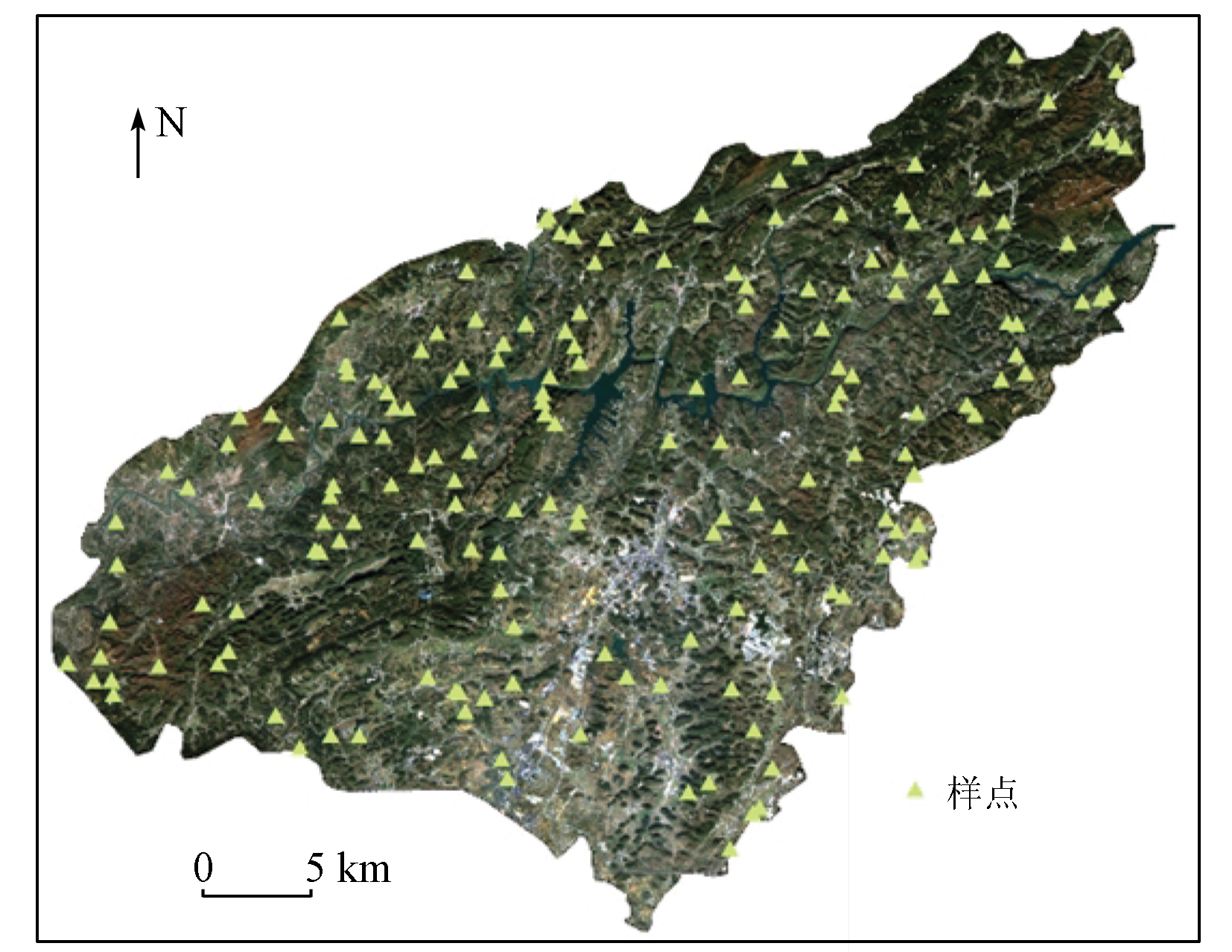
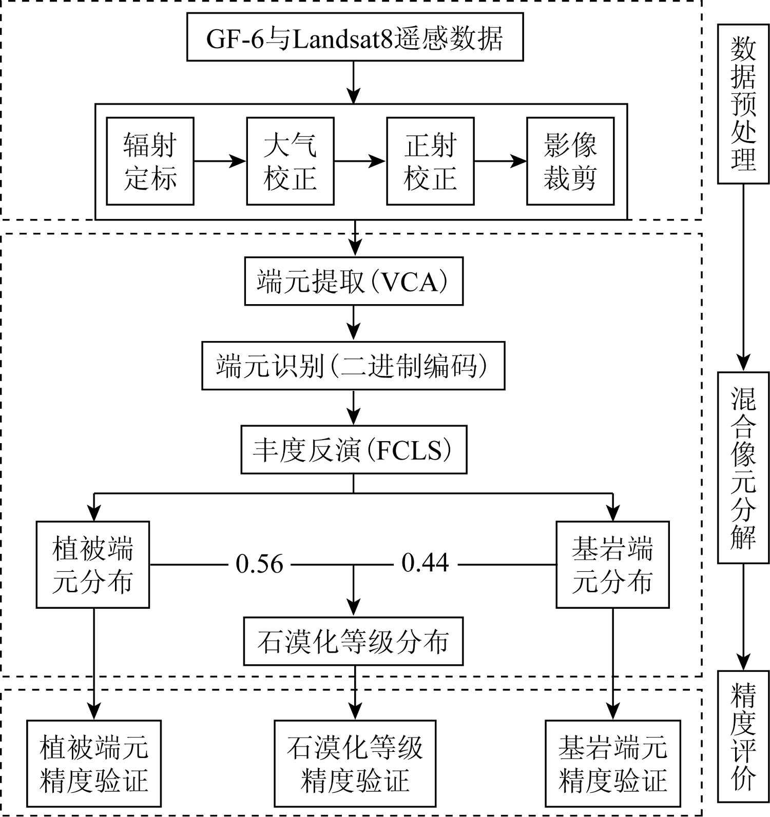
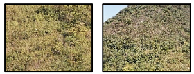
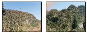
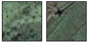
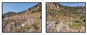
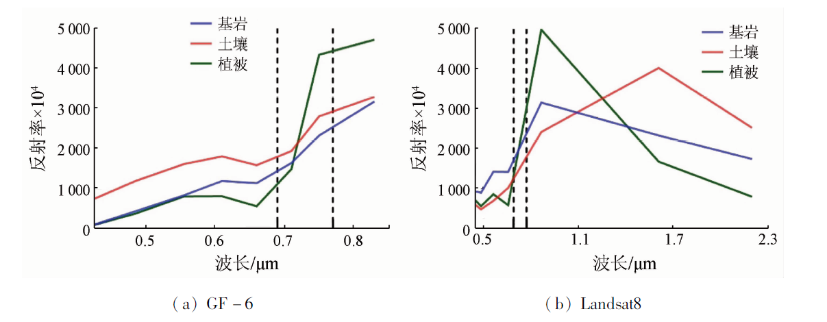
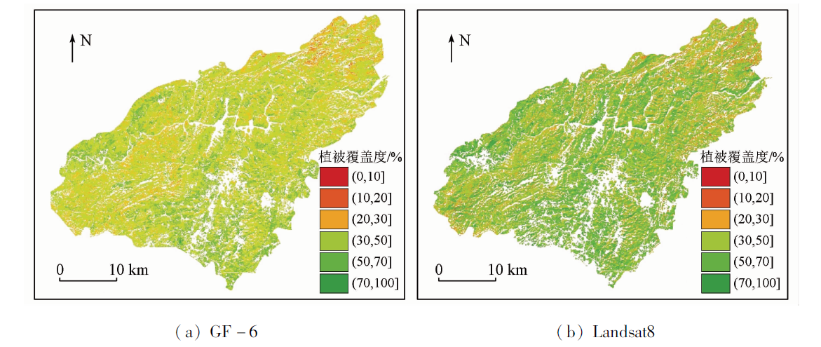
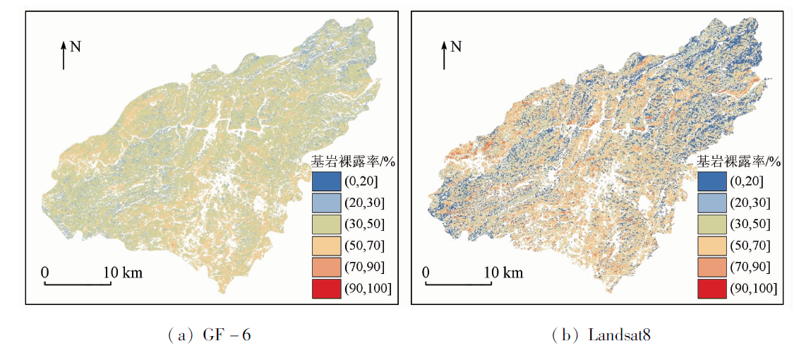
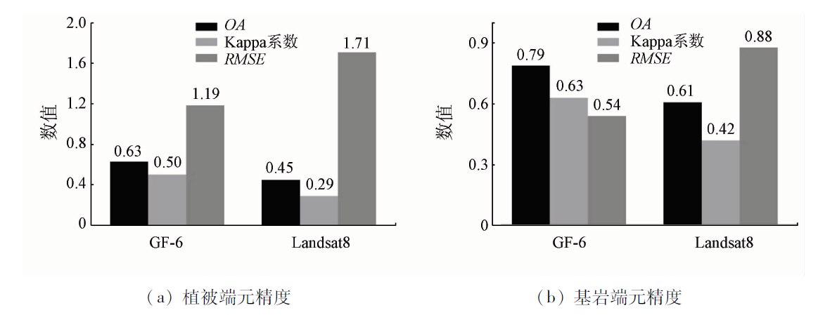
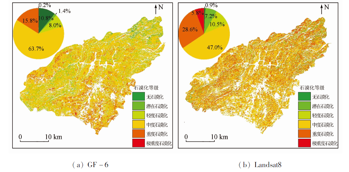
Abstract Different moderate-resolution remote sensing satellites exhibit various effects in extracting rocky desertification information using the pixel unmixing method. Comparing these various effects can help further improve the extraction accuracy of rocky desertification information. By extracting information on rocky desertification in Puding County, Guizhou Province from GF-6 and Landsat8 using the pixel unmixing method, this study investigated the end member characteristics and desertification grade differences between GF-6 and Landsat8. Furthermore, this study explored the feasibility and effectiveness of GF-6 in extracting rocky desertification information. The results are as follows: ① Within the red-edge band of GF-6 data, the vegetation end member exhibited significantly different spectrum curves from bedrock and soil end members, making it easier to identify the vegetation end member. ② In terms of end member extraction accuracy of rocky desertification information, GF-6 and Landsat8 yielded overall accuracy (OA) of 0.63 and 0.45 in extracting the vegetation end member, respectively, corresponding to Kappa coefficients of 0.50 and 0.29 and RMSEs of 1.19 and 1.71, respectively. Moreover, GF-6 and Landsat8 yielded OA of 0.79 and 0.61 in extracting the bedrock end member, respectively, corresponding to Kappa coefficients of 0.63 and 0.42 and RMSEs of 0.54 and 0.88, respectively. ③ In the evaluation of rocky desertification grades, GF-6 and Landsat8 yielded OA of 0.76 and 0.59 in extracting rocky desertification grades, respectively, corresponding to Kappa coefficients of 0.56 and 0.38 and RMSEs of 0.64 and 1.27. Therefore, GF-6 outperforms Landsat8 in the accuracy of extracting rocky desertification information using the pixel unmixing method. In addition, the red-edge band of GF-6 data can effectively identify the vegetation information in areas with rocky desertification. In summary, the pixel unmixing method based on GF-6 data can be practically applied to rocky desertification monitoring.
|
| Keywords
rocky desertification
GF-6
vertex component analysis method
fully constrained least squares method
pixel unmixing
|
|
|
|
Issue Date: 19 September 2023
|
|
|
| [1] |
王世杰. 喀斯特石漠化概念演绎及其科学内涵的探讨[J]. 中国岩溶, 2002(2):31-35.
|
| [1] |
Wang S J. Concept deduction and its connotation of Karst rocky desertification[J]. Carsologica Sinica, 2002(2):31-35.
|
| [2] |
姚永慧. 中国西南喀斯特石漠化研究进展与展望[J]. 地理科学进展, 2014, 33(1):76-84.
doi: 10.11820/dlkxjz.2014.01.009
|
| [2] |
Yao Y H. Progress and prospect of Karst rocky desertification research in Southwest China[J]. Progress in Geography, 2014, 33(1):76-84.
doi: 10.11820/dlkxjz.2014.01.009
|
| [3] |
Qian C, Qiang H, Wang F, et al. Optimization of rocky desertification classification model based on vegetation type and seasonal characteristic[J]. Remote Sensing, 2021, 13(15):2935.
doi: 10.3390/rs13152935
url: https://www.mdpi.com/2072-4292/13/15/2935
|
| [4] |
Zhang J Y, Dai M H, Wang L C, et al. The challenge and future of rocky desertification control in Karst areas in southwest China[J]. Solid Earth, 2016, 7(1):83-91.
doi: 10.5194/se-7-83-2016
url: https://se.copernicus.org/articles/7/83/2016/
|
| [5] |
Zhang J, Liu M, Liu X, et al. Spectral analysis of seasonal rock and vegetation changes for detecting Karst rocky desertification in southwest China[J]. International Journal of Applied Earth Observation and Geoinformation, 2021, 100:102337.
doi: 10.1016/j.jag.2021.102337
url: https://linkinghub.elsevier.com/retrieve/pii/S0303243421000441
|
| [6] |
种国双, 海月, 郑华, 等. 中国西南喀斯特石漠化治理现状及对策[J]. 长江科学院院报, 2021, 38(11):38-43.
doi: 10.11988/ckyyb.20210453
|
| [6] |
Zhong G S, Hai Y, Zheng H, et al. Current situation and measures of Karst rocky desertification control in Southwest China[J]. Journal of Yangtze River Scientific Research Institute, 2021, 38(11):38-43.
|
| [7] |
杜文鹏, 闫慧敏, 甄霖, 等. 西南岩溶地区石漠化综合治理研究[J]. 生态学报, 2019, 39(16):5798-5808.
|
| [7] |
Du W P, Yan H M, Zhen L, et al. The experience and practice of desertification control in Karst region of southwest China[J]. Acta Ecologica Sinica, 2019, 39(16):5798-5808.
|
| [8] |
Li Y, Xie J, Luo G, et al. The evolution of a Karst rocky desertification land ecosystem and its driving forces in the Houzhaihe area,China[J]. Open Journal of Ecology, 2015, 5(10):501-512.
doi: 10.4236/oje.2015.510041
url: http://www.scirp.org/journal/doi.aspx?DOI=10.4236/oje.2015.510041
|
| [9] |
Tong X, Wang K, Yue Y, et al. Quantifying the effectiveness of ecological restoration projects on long-term vegetation dynamics in the Karst regions of Southwest China[J]. International Journal of Applied Earth Observation and Geoinformation, 2017, 54:105-113.
doi: 10.1016/j.jag.2016.09.013
url: https://linkinghub.elsevier.com/retrieve/pii/S0303243416301702
|
| [10] |
Wang H, Li Q, Du X, et al. Quantitative extraction of the bedrock exposure rate based on unmanned aerial vehicle data and Landsat8 OLI image in a Karst environment[J]. Frontiers of Earth Science, 2018, 12(3):481-490.
doi: 10.1007/s11707-017-0681-9
|
| [11] |
王明明, 王世杰, 白晓永, 等. 典型小流域喀斯特石漠化演变特征及其关键表征因子与驱动因素[J]. 生态学报, 2019, 39(16):6083-6097.
|
| [11] |
Wang M M, Wang S J, Bai X Y, et al. Evolution characteristics of Karst rocky desertification in typical small watershed and the key characterization factor and driving factor[J]. Acta Ecologica Sinica, 2019, 39(16):6083-6097.
|
| [12] |
郑惠茹, 罗红霞, 向海燕, 等. 基于面向对象的石漠化山区植被信息提取及分布特征研究[J]. 长江流域资源与环境, 2018, 27(3):648-657.
|
| [12] |
Zheng H R, Luo H X, Xiang H Y, et al. Research on vegetation information extraction and distribution characteristics of rocky desertification area by means of object oriented approach[J]. Resources and Environment in the Yangtze Basin, 2018, 27(3):648-657.
|
| [13] |
周迪, 倪忠云, 杨振宇. 面向对象的喀斯特地区石漠化遥感信息提取研究——以贵州省大方地区为例[J]. 地质力学学报, 2018, 24(2):263-273.
|
| [13] |
Zhou D, Ni Z Y, Yang Z Y. Object-oriented remote sensing information extraction method for rocky desertification in Karst area: A case study of Dafang County,Guizhou[J]. Journal of Geomechanics, 2018, 24(2):263-273.
|
| [14] |
徐红枫, 王妍, 刘云根, 等. 基于Google Earth Engine的典型峰丛洼地石漠化时空演变与驱动因子分析——以西畴县为例[J]. 水土保持研究, 2022, 29(4):407-414.
|
| [14] |
Xu H F, Wang Y, Liu Y G, et al. Analysis of the spatial and temporal evolution and driving factors of rocky desertification in typical cluster depression areas in the past 30 years based on Google Earth Engine:Taking Xichou County as an example[J]. Research of Soil and Water Conservation, 2022, 29(4):407-414.
|
| [15] |
叶杰, 张斌, 许军强, 等. 遥感植被指数增强石漠化信息研究[J]. 地理空间信息, 2021, 19(9):14-18,157.
|
| [15] |
Ye J, Zhang B, Xu J Q, et al. Research on the enhancement of stony desertification information by remote sensing vegetation indexes[J]. Geospatial Information, 2021, 19(9):14-18,157.
|
| [16] |
Yang H, Deng F, Fu H C, et al. Estimation of rape-cultivated area based on decision tree and mixed pixel decomposition[J]. Journal of the Indian Society of Remote Sensing, 2021, 49: 1285-1292.
doi: 10.1007/s12524-021-01309-6
|
| [17] |
陈姣, 黄远程, 李朋飞. 多季相混合像元部分分解特征的不透水面分类[J]. 测绘科学, 2021, 46(4):90-99.
|
| [17] |
Chen J, Huang Y C, Li P F. Impervious surface area classification based on partial unmixing of multi-season mixed pixels[J]. Science of Surveying and Mapping, 2021, 46(4):90-99.
|
| [18] |
刘蓉姣, 张加龙, 陈培高. 基于混合像元分解的香格里拉市高山松空间分布变化研究[J]. 西北林学院学报, 2021, 36(1):9-17.
|
| [18] |
Liu R J, Zhang J L, Chen P G. Spatial distribution changes of the pinus densata forests in Shangrila City based on mixed pixel decomposition[J]. Journal of Northwest Forestry University, 2021, 36(1):9-17.
|
| [19] |
杨明星, 张加龙, 曹影, 等. 基于Landsat8的云南松光谱端元选择与评价研究[J]. 西南林业大学学报(自然科学), 2017, 37(3):165-169.
|
| [19] |
Yang M X, Zhang J L, Cao Y, et al. Evaluation on spectral endmember of pinus yunnanensis based on Landsat8[J]. Journal of Southwest Forestry University(Natural Sciences), 2017, 37(3):165-169.
|
| [20] |
方凌江, 粘永健, 雷树涛, 等. 基于顶点成分分析的高光谱图像端元提取算法[J]. 舰船电子工程, 2014, 34(8):154-157,181.
|
| [20] |
Fang L J, Zhan Y J, Lei S T, et al. Endmembers extraction for hyperspectral images based on vertex component analysis[J]. Ship Electronic Engineering, 2014, 34(8):154-157,181.
|
| [21] |
王丽, 王威, 刘勃妮. 顶点成分分析法应用于高光谱图像端元提取[J]. 信息技术, 2022(1):37-43.
|
| [21] |
Wang L, Wang W, Liu B N. Application of vertex component analysis in end member extraction for hyperspectral image[J]. Information Technology, 2022(1):37-43.
|
| [22] |
王忠良. 基于线性混合模型的高光谱图像压缩感知研究[D]. 西安: 西北工业大学, 2015.
|
| [22] |
Wang Z L. Study on compressive sensing of hyperspectral imagery based on linear mixing models[D]. Xi’an: Northwestern Polytechnical University, 2015.
|
| [23] |
张文源, 王百田. 贵州喀斯特石漠化分类分级探讨[J]. 南京林业大学学报(自然科学版), 2015, 39(2):148-154.
|
| [23] |
Zhang W Y, Wang B T. Discussion on classification and gradation of Karst rocky desertification in Guizhou Province[J]. Journal of Nanjing Forestry University ( Natural Sciences Edition), 2015, 39(2):148-154.
|
| [24] |
胡顺光, 张增祥, 夏奎菊. 遥感石漠化信息的提取[J]. 地球信息科学学报, 2010, 12(6):870-879.
|
| [24] |
Hu S G, Zhang Z X, Xia K J. Information extraction of Karst rocky desertification using remote sensing[J]. Journal of Geo-Information Science, 2010, 12(6):870-879.
|
| [25] |
王睿卿, 蒋晓辉, 聂桐. 基于地理探测器的珠江流域NDVI时空变化及驱动力分析[J]. 人民珠江, 2022, 43(7):61-73.
|
| [25] |
Wang R Q, Jiang X H, Nie T. Spatiotemporal varitation NDVI and its driving forces in the Pearl River basin based on geodetector[J]. Pearl River, 2022, 43(7):61-73.
|
| [26] |
习慧鹏, 王世杰, 白晓永, 等. 西南典型喀斯特地区石漠化时空演变特征——以贵州省普定县为例[J]. 生态学报, 2018, 38(24):8919-8933.
|
| [26] |
Xi H P, Wang S J, Bai X Y, et al. Spatio-temporal characteristics of rocky desertification in typical Karst area of Southwest China:A case study of Puding Country,Guizhou Province[J]. Acta Ecologica Sinica, 2018, 38(24):8919-8933.
|
| [27] |
何晓宁, 曹建农, 高坡, 等. 基于顶点成分分析法的端元提取改进算法[J]. 测绘通报, 2013(7):30-34,81.
|
| [27] |
He X N, Cao J N, Gao P, et al. An improved algorithm of endmember extraction based on vertex component analysis[J]. Bulletin of Surveying and Mapping, 2013(7):30-34,81.
|
| [28] |
Pu J, Zhao X, Dong P, et al. Extracting information on rocky desertification from satellite images:A comparative study[J]. Remote Sensing, 2021, 13(13):2497.
doi: 10.3390/rs13132497
url: https://www.mdpi.com/2072-4292/13/13/2497
|
|
Viewed |
|
|
|
Full text
|
|
|
|
|
Abstract
|
|
|
|
|
Cited |
|
|
|
|
| |
Shared |
|
|
|
|
| |
Discussed |
|
|
|
|
 2023,
Vol. 35
2023,
Vol. 35