|
|
 |
|

|
|
|
Knowledge-based remote sensing image fusion method |
KONG Ailing1( ), ZHANG Chengming1(), LI Feng2, HAN Yingjuan3, SUN Huanying4, DU Manfei4 ), ZHANG Chengming1(), LI Feng2, HAN Yingjuan3, SUN Huanying4, DU Manfei4 |
1. College of Information Science and Engineering, Shandong Agricultural University, Taian 271018, China
2. Shandong Provincal Climate Center, Jinan 250031, China
3. Key Laboratory for Meteorological Disaster Monitoring and Early Warning and Risk Management of Characteristic Agriculture in Arid Regions, CMA, Yinchuan 750002, China
4. PIESAT Information Technology Co., Ltd., Beijing 100195, China |
|
|
|
|
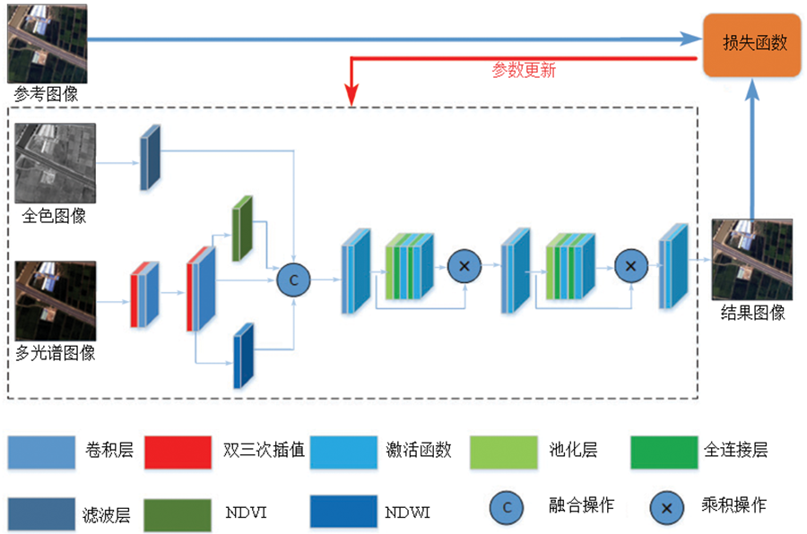
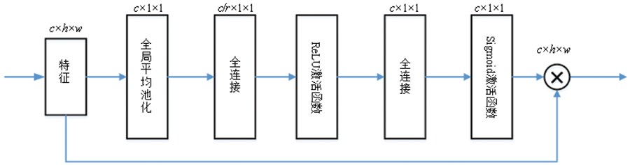
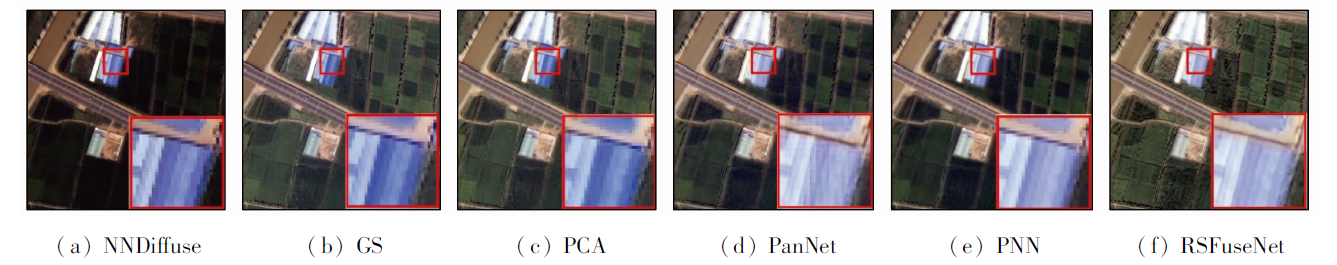
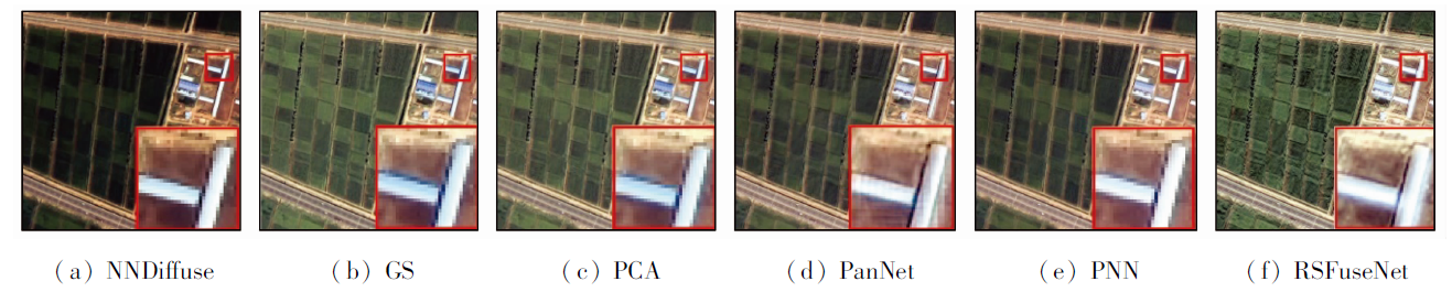
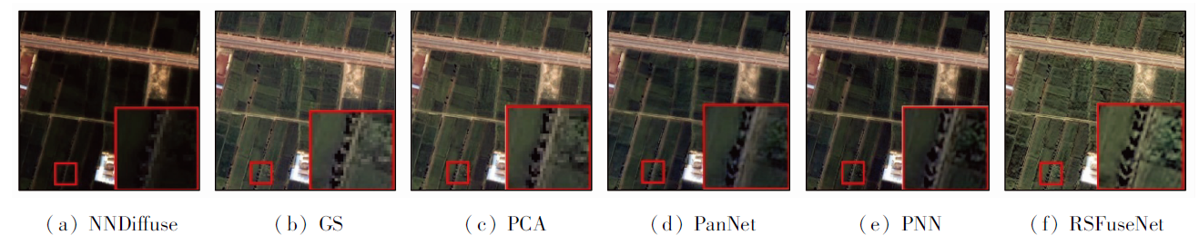
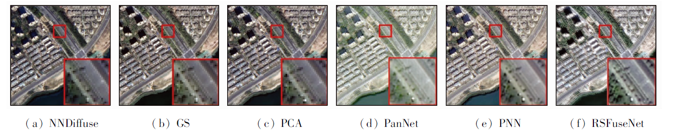
Abstract The remote sensing image fusion technology can combine multi-source images containing complementary information to obtain images with richer content and higher spectral quality, thus it is the key and foundation of remote sensing applications. Aiming at the problems of spectral distortion and spatial structure distortion that are prone to occur in the process of remote sensing image fusion, the knowledge-based remote sensing image FuseNet (RSFuseNet) was constructed based on the attention mechanism and using normalized difference vegetation index (NDVI) and normalized difference water index (NDWI) as prior knowledge. Firstly, considering that the high-pass filtering can fully extract edge texture details, a high-pass filtering module was constructed to extract high-frequency details of panchromatic images. Secondly, NDVI and NDWI were extracted from multi-spectral images. Then, an adaptive squeeze-and-excitation (SE) module was constructed to recalibrate the input features. Finally, the adaptive SE module was combined with the convolution unit to perform fusion processing on the input features. The experiment was conducted using Gaofen 6 remote sensing image as the data source, and selecting Gram-Schmidt (GS) transformation, principal component analysis (PCA), a deep network architecture for pan-sharpening (PanNet), and pansharpening by convolutional neural networks (PNN) models as comparative models. The experimental results show that the peak signal to noise ratio (PSNR) index (40.5) and the structural similarity (SSIM) index (0.98) of the RSFuseNet model are better than those of comparative models, indicating that the method in this study has obvious advantages in remote sensing image fusion.
|
| Keywords
image fusion
prior knowledge
convolutional neural network
attention mechanism
GF-6
|
|
|
|
Corresponding Authors:
ZHANG Chengming
E-mail: 2019110580@sdau.edu.cn;chming@sdau.edu.cn
|
|
Issue Date: 20 June 2022
|
|
|
| [1] |
王建宇, 王跃明, 李春来. 高光谱成像系统的噪声模型和对辐射灵敏度的影响[J]. 遥感学报, 2010, 14(4):607-620.
|
| [1] |
Wang J Y, Wang Y M, Li C L. Noise model of hyperspectral imaging system and influence on radiation sensitivity[J]. Journal of Remote Sensing, 2010, 14(4):607-620.
|
| [2] |
Vivone G, Alparone L, Chanussot J, et al. A critical comparison among pansharpening algorithms[J]. IEEE Transactions on Geoscience and Remote Sensing, 2015, 53(5):2565-2586.
doi: 10.1109/TGRS.2014.2361734
url: http://ieeexplore.ieee.org/document/6998089/
|
| [3] |
Xie B, Zhang H, Huang B. Revealing implicit assumptions of the component substitution pansharpening methods[J]. Remote Sensing, 2017, 9(5):443-458.
doi: 10.3390/rs9050443
url: http://www.mdpi.com/2072-4292/9/5/443
|
| [4] |
Yong Y, Wan W, Huang S, et al. A novel pan-sharpening framework based on matting model and multiscale transform[J]. Remote Sensing, 2017, 9(4):391.
doi: 10.3390/rs9040391
url: http://www.mdpi.com/2072-4292/9/4/391
|
| [5] |
王晓艳, 刘勇, 蒋志勇. 一种基于结构相似度的IHS变换融合算法[J]. 遥感技术与应用, 2011, 26(5):670-676.
|
| [5] |
Wang X Y, Liu Y, Jiang Z Y. An IHS fusion method based on structural similarity[J]. Remote Sensing Technology and Application, 2011, 26(5):670-676.
|
| [6] |
Yang Y, Wan W, Huang S, et al. Remote sensing image fusion based on adaptive IHS and multiscale guided filter[J]. IEEE Access, 2017(4):4573-4582.
|
| [7] |
W Dong, S Xiao, X Xue, et al. An improved hyperspectral pansharpening algorithm based on optimized injection model[J]. IEEE Access, 2019(7):16718-16729.
|
| [8] |
Xu L, Zhang Y, Gao Y, et al. Using guided filtering to improve gram-schmidt based pansharpening method for GeoEye-1 satellite images[J]. Proceedings of the 4th International Conference on Information Systems and Computing Technology, 2016(64):33-37.
|
| [9] |
Aiazzi B, Alparone L, Baronti S, et al. MTF-tailored multiscale fusion of high-resolution MS and Pan imagery[J]. Photogrammetric Engineering & Remote Sensing, 2015, 72(5):591-596.
|
| [10] |
Vivone G, Restaino R, Mura M D, et al. Contrast and error-based fusion schemes for multispectral image pansharpening[J]. IEEE Geoscience and Remote Sensing Letters, 2013, 11(5):930-934.
doi: 10.1109/LGRS.2013.2281996
url: http://ieeexplore.ieee.org/document/6616569/
|
| [11] |
Alparone, Luciano, Baronti, et al. Spatial methods for multispectral pansharpening:Multiresolution analysis demystified[J]. IEEE Transactions on Geoscience & Remote Sensing, 2016(54):2563-2576.
|
| [12] |
Nencini F, Garzelli A, Baronti S, et al. Remote sensing image fusion using the curvelet transform[J]. Information Fusion, 2007, 8(2):143-156.
doi: 10.1016/j.inffus.2006.02.001
url: https://linkinghub.elsevier.com/retrieve/pii/S1566253506000340
|
| [13] |
Lu X, Zhang J, Zhang Y. An improved non-subsampled contourlet transform-based hybrid pan-sharpening algorithm[C]// 2017 IEEE International Geoscience and Remote Sensing Symposium. Fort Worth: IEEE, 2017:3393-3396.
|
| [14] |
James R, Vadivel M. Improvement of spectral and spatial information using modified WAMM and modified bi-cubic interpolation method in non-subsampled contourlet transform domain[C]// 2015 International Conference on Robotics,Automation,Control and Embedded Systems (RACE). Chennai India: IEEE, 2015:1-5.
|
| [15] |
Zhang Z, Luo X, Wu X. A new pansharpening method using statistical model and shearlet transform[J]. IEEE Technical Review, 2014, 31(5):308-316.
|
| [16] |
Wang X, Bai S, Li Z, et al. The PAN and MS Image pansharpening algorithm based on adaptive neural network and sparse representation in the NSST domain[J]. IEEE Access, 2019(7):52508-52521.
|
| [17] |
Yin H T. Sparse representation based pan-sharpening with details injection model[J]. Signal Processing, 2015(113):218-227.
|
| [18] |
Giuseppe M, Davide C, Luisa V, et al. Pansharpening by convolutional neural networks[J]. Remote Sensing, 2016, 8(7):594.
doi: 10.3390/rs8070594
url: http://www.mdpi.com/2072-4292/8/7/594
|
| [19] |
Scarpa G, Vitale S, Cozzolino D. Target-adaptive CNN-based pansharpening[J]. IEEE Transactions on Geoscience & Remote Sensing, 2018, 56(9):5443-5457.
|
| [20] |
Yuan Q, Wei Y, Meng X, et al. A multiscale and multidepth convolutional neural network for remote sensing imagery pan-sharpening[J]. IEEE Journal of Selected Topics in Applied Earth Observations and Remote Sensing, 2018, 11(3),978-989.
doi: 10.1109/JSTARS.2018.2794888
url: https://ieeexplore.ieee.org/document/8281501/
|
| [21] |
Yang J, Fu X, Hu Y, et al. PanNet:A deep network architecture for pan-sharpening[C]// 2017 IEEE International Conference on Computer Vision(ICCV). Venice Italy: IEEE, 2017:5449-5457.
|
| [22] |
Shao Z, Cai J. Remote sensing image fusion with deep convolutional neural network[J]. IEEE Journal of Selected Topics in Applied Earth Observations and Remote Sensing, 2018, 11(5):1656-1669.
doi: 10.1109/JSTARS.2018.2805923
url: https://ieeexplore.ieee.org/document/8314460/
|
| [23] |
Azarang A, Manoochehri H E, Kehtarnavaz N. Convolutional autoencoder-based multispectral image fusion[J]. IEEE Access, 2019, 7:35673-35683.
doi: 10.1109/ACCESS.2019.2905511
|
| [24] |
Jie H, Li S, Gang S, et al. Squeeze-and-excitation networks[J]. IEEE Transactions on Pattern Analysis and Machine Intelligence, 2020, 42(8):2011-2023.
doi: 10.1109/TPAMI.2019.2913372
pmid: 31034408
|
| [25] |
聂文昌. 融合先验知识的深度学习目标识别与定位研究[D]. 哈尔滨: 哈尔滨工程大学, 2019.
|
| [25] |
Nie Wenchang. Research on target recognition and locationbased on prior knowledge using deep learning[D]. Harbin: Harbin Engineering University, 2019.
|
| [26] |
Pushparaj J, Hegde A V. Evaluation of pan-sharpening methods for spatial and spectral quality[J]. Applied Geomatics, 2016, 9(1):1-12.
doi: 10.1007/s12518-016-0179-2
url: http://link.springer.com/10.1007/s12518-016-0179-2
|
| [27] |
杨丽萍, 马孟, 谢巍, 等. 干旱区Landsat8全色与多光谱数据融合算法评价[J]. 国土资源遥感, 2019, 31(4):11-19.doi: 10.6046/gtzyyg.2019.04.02.
doi: 10.6046/gtzyyg.2019.04.02
|
| [27] |
Yang L P, Ma M, Xie W, et al. Fusion algorithm evaluation of Landsat 8 panchromatic and multispectral images in arid regions[J]. Remote Sensing for Land and Resources, 2019, 31(4):11-19.doi: 10.6046/gtzyyg.2019.04.02.
doi: 10.6046/gtzyyg.2019.04.02
|
| [28] |
Vivone G, Alparone L, Chanussot J, et al. A critical comparison among pansharpening algorithms[J]. IEEE Transactions on Geoscience and Remote Sensing, 2015, 53(5):2565-2586.
doi: 10.1109/TGRS.2014.2361734
url: http://ieeexplore.ieee.org/document/6998089/
|
|
Viewed |
|
|
|
Full text
|
|
|
|
|
Abstract
|
|
|
|
|
Cited |
|
|
|
|
| |
Shared |
|
|
|
|
| |
Discussed |
|
|
|
|
 2022,
Vol. 34
2022,
Vol. 34