|
|
 |
|

|
|
|
A study on the changes in coastal tidal flats in the Laizhou Bay based on MSIC and OTSU |
LI Yi1,2( ), CHENG Lina2,3(), LU Yingying2,4, ZHANG Bochun1,2, YU Sen1,2, JIA Mingming2 ), CHENG Lina2,3(), LU Yingying2,4, ZHANG Bochun1,2, YU Sen1,2, JIA Mingming2 |
1. School of Surveying, Mapping and Exploration Engineering, Jilin Jianzhu University, Changchun 130118, China
2. Key Laboratory of Wetland Ecology and Environment, Northeast Institute of Geography and Agroecology, Chinese Academy of Sciences, Changchun 130102, China
3. College of Earth Science, Jilin University, Changchun 130061, China
4. Changchun New District Beihu Yingcai School, Changchun 130000, China |
|
|
|
|
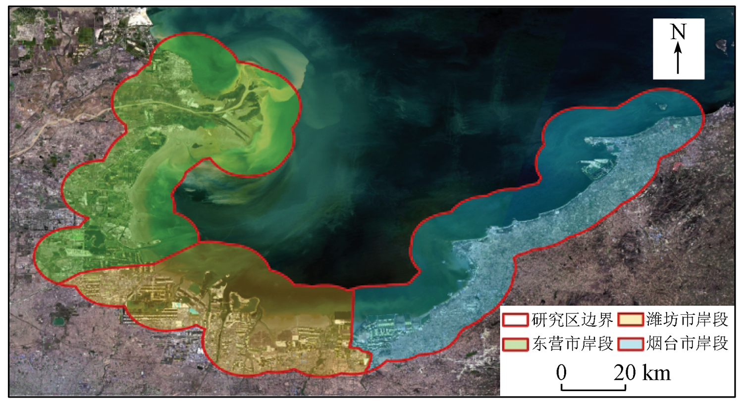
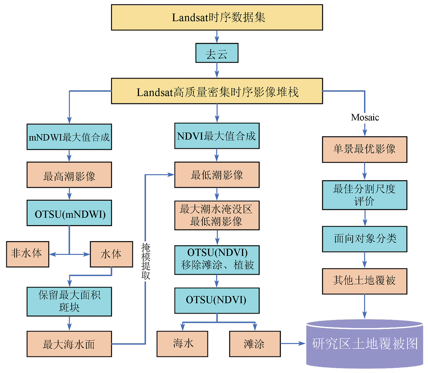
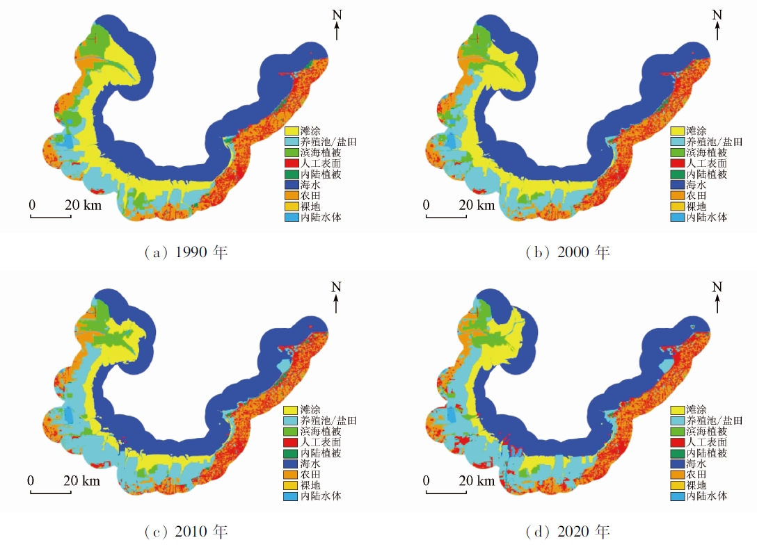
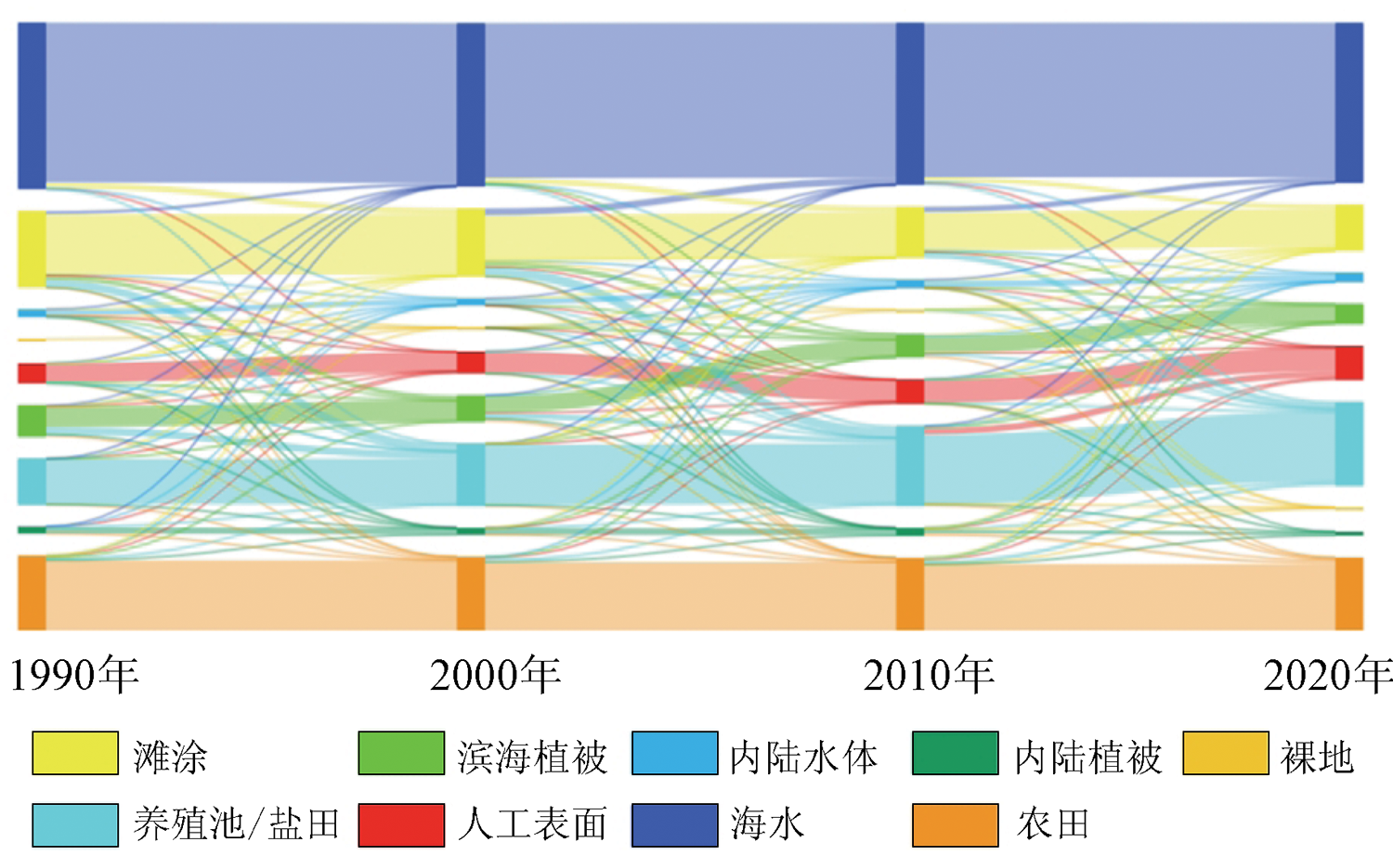
Abstract Coastal tidal flats, as a major type of coastal wetlands, have significant ecological value in maintaining biodiversity and influencing global climate and environmental change. Since they are only exposed in their entirety at the lowest tide, the previous remote sensing interpretation results showed significant omissions and misclassifications of the tidal flats. Based on the Google Earth Engine (GEE) platform and the Landsat series satellite data, this study constructed high-quality dense time series image stacks for four time periods, i.e., 1990, 2000, 2010, and 2020. Then, these image stacks were combined with the maximum spectral index composite (MSIC) algorithm and the Otsu algorithm (OTSU) for rapid and automatic extraction of coastal tidal flats resources in Laizhou Bay of China. Furthermore, the land cover around the coastal tidal flats was delineated based on the object-oriented analysis technology and the fuzzy-based segmentation parameter (FbSP) optimal scale. Finally, the spatial and temporal evolution patterns of the coastal tidal flats were analyzed. The results are shown as follows. During 1990—2020, the coastal tidal flats in Laizhou Bay gradually decreased, with an area of 822.38 km2 in 2020, a reduction of about 40% compared with that in 1990. The largest reduction was 304.78 km2 during 2000—2010. The coastal tidal flats near the Yellow River estuary showed a seaward migration, while the coast tidal flat patches in other regions of Laizhou Bay showed a landward migration. Human activities were the dominant factors in the changes in tidal flats in Laizhou Bay in the past 30 years. Among them, the expansion of aquaculture ponds/salt fields directly encroached on 414.20 km2 of coastal tidal flats.
|
| Keywords
coastal tidal flat
Landsat imagery
MSIC
OTSU
Google Earth Engine (GEE)
|
|
|
|
Issue Date: 27 December 2022
|
|
|
| [1] |
程丽娜, 钟才荣, 李晓燕, 等. Sentinel-2密集时间序列数据和Google Earth Engine的潮间带湿地快速自动分类[J]. 遥感学报, 2022, 26(2):348-357.
|
| [1] |
Cheng L N, Zhong C R, Li X Y, et al. Rapid and automatic classification of intertidal wetlands based on intensive time series Sentinel-2 images and Google Earth Engine[J]. National Remote Sensing Bulletin, 2022, 26(2):348-357.
|
| [2] |
崔保山, 谢湉, 王青, 等. 大规模围填海对滨海湿地的影响与对策[J]. 中国科学院院刊, 2017, 32(4):418-425.
|
| [2] |
Cui B S, Xie T, Wang Q, et al. Impact of large-scale reclamation on coastal wetlands and implications for ecological restoration,compensation,and sustainable exploitation framework[J]. Bulletin of Chinese Academy of Sciences, 2017, 32(4):418-425.
|
| [3] |
李雅, 刘玉卿. 滩涂湿地生态系统服务价值评估研究综述[J]. 上海国土资源, 2017, 38(4):86-92.
|
| [3] |
Li Y, Liu Y Q. Review of ecosystem service evaluation of a tidal flat wetland[J]. Shanghai Land and Resources, 2017, 38(4):86-92.
|
| [4] |
朱明君. 我国滩涂资源可持续性利用战略研究[J]. 中国土地科学, 2000, 14(2):8-12,47.
|
| [4] |
Zhu M J. Research on sustainable utilization strategy of tidal flat resources in my country[J]. China Land Science, 2000, 14(2):8-12,47.
|
| [5] |
薛超波, 王国良, 金珊. 海洋滩涂贝类养殖环境的研究现状[J]. 生态环境, 2004, 13(1):116-118.
|
| [5] |
Xue C B, Wang G L, Jin S. Review on the culture environment of the marine intertidal shellfish[J]. Ecological Environment, 2004, 13(1):116-118.
|
| [6] |
张长宽, 陈欣迪. 海岸带滩涂资源的开发利用与保护研究进展[J]. 河海大学学报(自然科学版), 2016, 44(1):25-33.
|
| [6] |
Zhang C K, Chen X D. Advances in development,utilization,and protection of coastal tidal flats[J]. Journal of Hohai University(Natural Sciences), 2016, 44(1):25-33.
|
| [7] |
Murray N J, Phinn S R, DeWitt M, et al. The global distribution and trajectory of tidal flats[J]. Nature, 2019, 565(7738):222-225.
doi: 10.1038/s41586-018-0805-8
url: https://doi.org/10.1038/s41586-018-0805-8
|
| [8] |
Murray N J, Stuarrt R P, Robert S C, et al. Continental scale mapping of tidal flats across east Asia using the Landsat archive[J]. Remote Sensing, 2012, 4(11),3417-3426.
doi: 10.3390/rs4113417
url: http://www.mdpi.com/2072-4292/4/11/3417
|
| [9] |
Wang X X, Xiao X G, Zou Z H, et al. Tracking annual changes of coastal tidal flats in China during 1986—2016 through analyses of Landsat images with Google Earth Engine[J]. Remote Sensing of Environment, 2020, 238:110987.
doi: 10.1016/j.rse.2018.11.030
url: https://linkinghub.elsevier.com/retrieve/pii/S003442571830539X
|
| [10] |
Jia M M, Wang Z M, Mao D H, et al. Rapid,robust,and automated mapping of tidal flats in China using time series Sentinel-2 images and Google Earth Engine[J]. Remote Sensing of Environment, 2021, 255:112285.
doi: 10.1016/j.rse.2021.112285
url: https://linkinghub.elsevier.com/retrieve/pii/S0034425721000031
|
| [11] |
智超, 吴文挺, 苏华. 潮汐和植被物候影响下的潮间带湿地遥感提取[J]. 遥感学报, 2020, 26(2):373-385.
|
| [11] |
Zhi C, Wu W T, Su H. Mapping the intertidal wetlands of Fujian Province based on tidal dynamics and vegetational phonology[J]. National Remote Sensing Bulletin, 2020, 26(2):373-385.
|
| [12] |
Zhao C P, Qin C Q, Teng J K. Mapping large-area tidal flats without the dependence on tidal elevations:A case study of southern China[J]. ISPRS Journal of Photogrammetry and Remote Sensing, 2020, 159:256-270.
doi: 10.1016/j.isprsjprs.2019.11.022
url: https://linkinghub.elsevier.com/retrieve/pii/S0924271619302813
|
| [13] |
李振, 黄海军. 胶州湾海岸带土地利用/覆被变化研究[J]. 国土资源遥感, 2010, 22(4):71-76.doi:10.6046/gtzyyg.2010.04.16.
doi: 10.6046/gtzyyg.2010.04.16
|
| [13] |
Li Z, Huang H J. Land use and land cover change of the coastal zone around Jiaozhou Bay[J]. Remote Sensing for Land and Resources, 2010, 22(4):71-76.doi:10.6046/gtzyyg.2010.04.16.
doi: 10.6046/gtzyyg.2010.04.16
|
| [14] |
张康永. 基于Google Earth Engine平台时序影像分析的滨海滩涂遥感制图及演变分析[M]. 深圳: 深圳大学, 2019.
|
| [14] |
Zhang K Y. Remote sensing mapping and evolution analysis of coastal tidal flats based on time series image analysis on Google Earth Engine platform[M]. Shenzhen: Shenzhen University, 2019.
|
| [15] |
Otsu N. A threshold selection method from gray-level histograms[J]. IEEE Transactions on System Man and Cybernetics, 1979, 9(1):62-66.
doi: 10.1109/TSMC.1979.4310076
url: http://ieeexplore.ieee.org/document/4310076/
|
| [16] |
陈云浩, 冯通, 史培军, 等. 基于面向对象和规则的遥感影像分类研究[J]. 武汉大学学报(信息科学版), 2006, 31(4):316-320.
|
| [16] |
Chen Y H, Feng T, Shi P J, et al. Classification of remote sensing image based on object oriented and class rules[J]. Geomatics and Information Science of Wuhan University, 2006, 31(4):316-320.
|
| [17] |
Volker W. Object-based classification of remote sensing data for change detection[J]. ISPRS Journal of Photogrammetry and Remote Sensing, 2004, 58(3-4):225-238.
doi: 10.1016/j.isprsjprs.2003.09.007
url: https://linkinghub.elsevier.com/retrieve/pii/S0924271603000595
|
| [18] |
贾明明, 王宗明, 毛德华, 等. 面向可持续发展目标的中国红树林近50年变化分析[J]. 科学通报, 2021, 66(30):3886-3901.
|
| [18] |
Jia M M, Wang Z M, Mao D H, et al. Spatial-temporal changes of China’s mangrove forests over the past 50 years:An analysis towards the sustainable development goals(SDGs)[J]. Chinese Science Bulletin, 2021, 66(30):3886-3901.
|
| [19] |
王琰, 牟秀娟, 徐承芳. 莱州湾海洋生态环境状况与污染防治策略初探[J]. 海洋环境科学, 2021, 40(6):823-831,837.
|
| [19] |
Wang Y, Mu X J, Xu C F. Preliminary study on marine ecological environment and pollution prevention in Laizhou Bay[J]. Marine Environmental Science, 2021, 40(6):823-831,837.
|
| [20] |
国家海洋局. 2020年中国海平面公报[EB/OL].(2021-4-26)[2020-4-20]. http://gi.mnr.gov.cn/202104/t20210426_2630186.html.
url: http://gi.mnr.gov.cn/202104/t20210426_2630186.html
|
| [20] |
State Oceanic Administration. 2020 China sea level bulletin[EB/OL].(2021-4-26)[2020-4-20]. http://gi.mnr.gov.cn/202104/t20210426_2630186.html.
url: http://gi.mnr.gov.cn/202104/t20210426_2630186.html
|
| [21] |
陈斌, 刘健, 高飞. 莱州湾悬沙输运机制研究[J]. 水科学进展, 2015, 26(6):857-866.
|
| [21] |
Chen B, Liu J, Gao F. Suspended sediment transport mechanism in Laizhou bay[J]. Advances in Water Science, 2015, 26(6):857-866.
|
| [22] |
孙伟富. 1978—2009年莱州湾海岸线变迁研究[D]. 青岛: 国家海洋局第一海洋研究所, 2010.
|
| [22] |
Sun W F. Research on the shoreline change of Laizhou Bay from 1978 to 2009[D]. Qingdao: Oceanography State Oceanic Administration, 2010.
|
| [23] |
程义吉, 高菁. 莱州湾海域水文特征及冲淤变化分析[J]. 海岸工程, 2006, 25(3):1-6.
|
| [23] |
Cheng Y J, Gao J. Analysis of hydrological charteristics and changes in scour and silting in the Laizhou Bay area[J]. Coastal Engineering, 2006, 25(3):1-6.
doi: 10.1016/0378-3839(94)00040-5
url: https://linkinghub.elsevier.com/retrieve/pii/0378383994000405
|
| [24] |
山东省统计局. 山东省第七次全国人口普查公报(第二号)[EB/OL].(2020-5-21)[2022-4-20]. http://tjj.shandong.gov.cn/art/2021/5/21/art_6293_10287511.html.
url: http://tjj.shandong.gov.cn/art/2021/5/21/art_6293_10287511.html
|
| [24] |
Shandong Provincial Bureau of Statistics. Bulletin of the seventh national census of Shandong Province (No.2)[EB/OL].(2020-5-21)[2022-4-20]. http://tjj.shandong.gov.cn/art/2021/5/21/art_6293_10287511.html.
url: http://tjj.shandong.gov.cn/art/2021/5/21/art_6293_10287511.html
|
| [25] |
黄皓, 陈锦辉, 胡自宁. 近50年来广西海岸滩涂变化特征分析[J]. 海洋科学, 2007, 31(1):37-42.
|
| [25] |
Huang H, Chen J H, Hu Z N. Analysis on the characteristics of changeable intertidal zones along Guangxi coast in the late of 50 years[J]. Marine Sciences, 2007, 31(1):37-42.
|
| [26] |
吴珊珊. 莱州湾南岸滨海湿地的景观格局变化及其生态脆弱性评价[D]. 济南: 山东师范大学, 2009.
|
| [26] |
Wu S S. Analysis on landscape pattern change and ecological environmental vulnerability assessment of the Southern coastal wetland of Laizhou bay[D]. Jinan: Shandong Normal University, 2009.
|
| [27] |
姚云长, 任春颖, 王宗明, 等. 1985年和2010年中国沿海盐田和养殖池遥感监测[J]. 湿地科学, 2016, 14(6):874-882.
|
| [27] |
Yao Y C, Ren C Y, Wang Z M, et al. Monitoring of salt ponds and aquaculture ponds in the coastal zone of China in 1985 and 2010[J]. Wetland Science, 2016, 14(6):874-882.
|
|
Viewed |
|
|
|
Full text
|
|
|
|
|
Abstract
|
|
|
|
|
Cited |
|
|
|
|
| |
Shared |
|
|
|
|
| |
Discussed |
|
|
|
|
 2022,
Vol. 34
2022,
Vol. 34