|
|
 |
|

|
|
|
An improved ICM algorithm for remote sensing image segmentation |
| Jun YANG1, Jianjie PEI2 |
1. School of Electronic and Information Engineering, Lanzhou Jiaotong University, Lanzhou 730070, China
2. Faculty of Geomatics, Lanzhou Jiaotong University & Gansu Provincial Engineering Laboratory for National Geographic State Monitoring, Lanzhou 730070, China; |
|
|
|
|
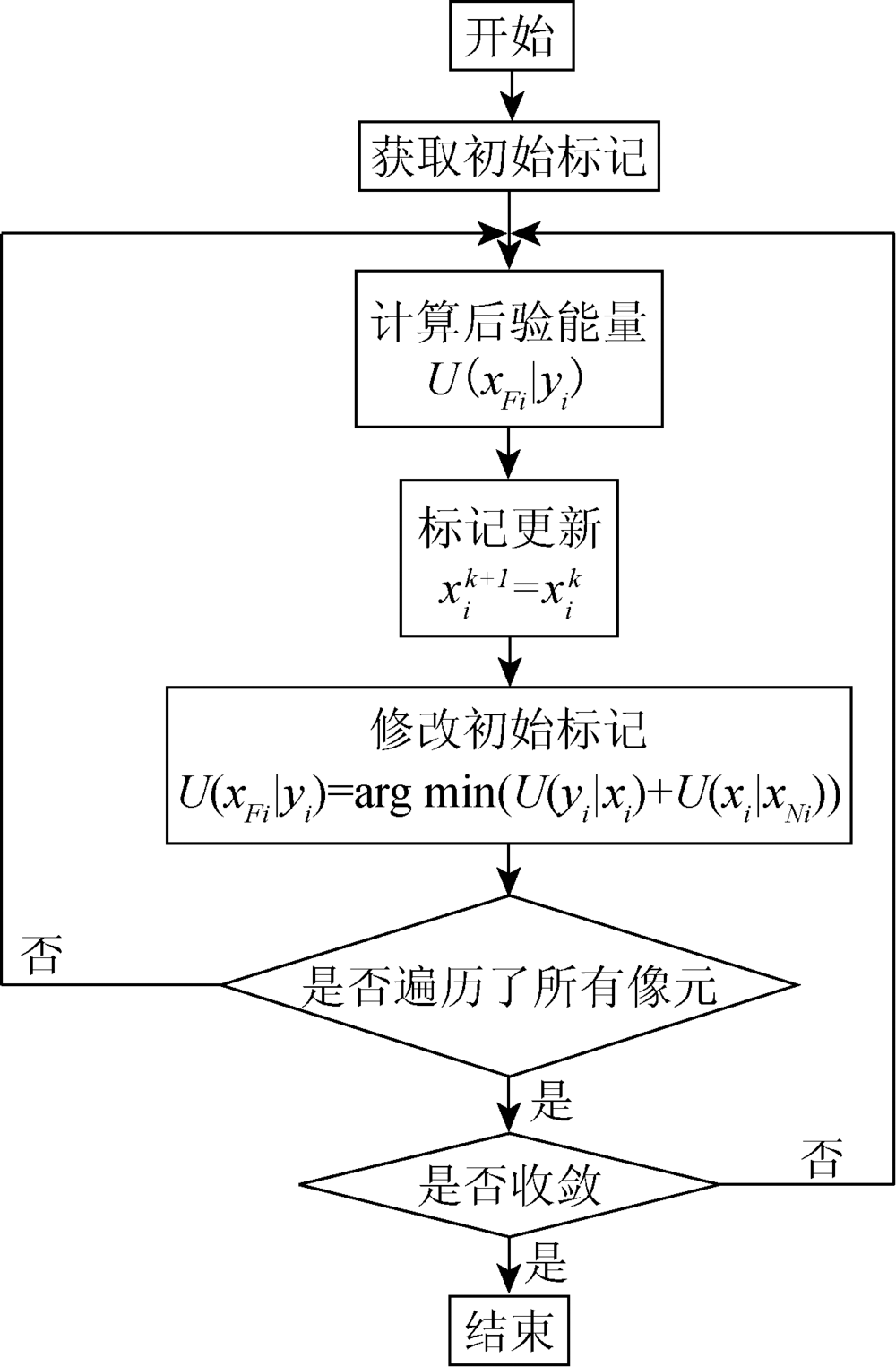
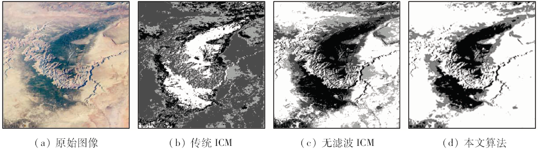
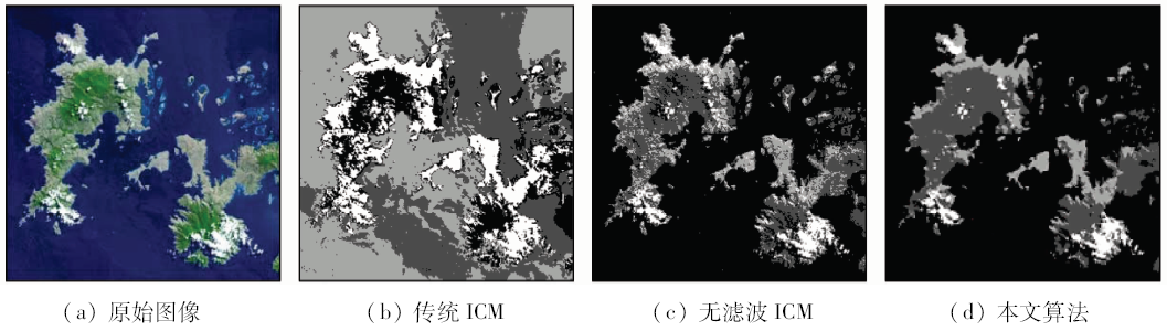
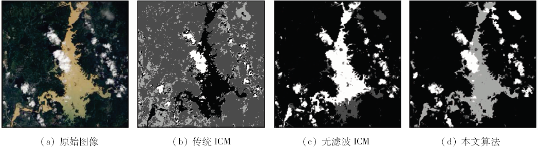
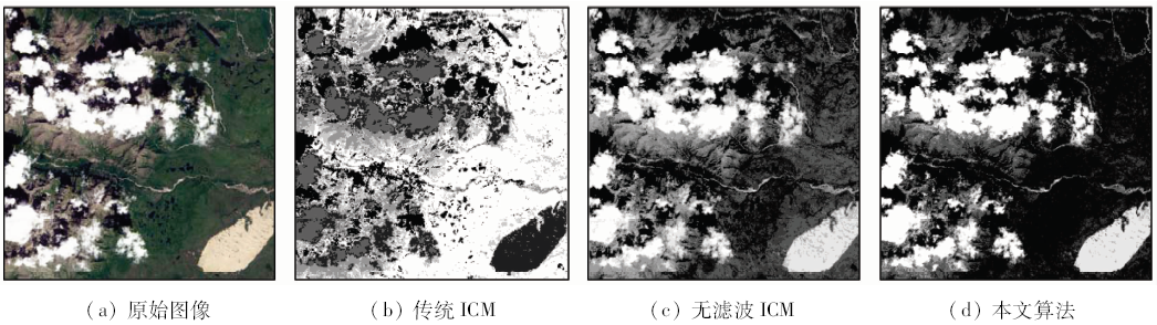
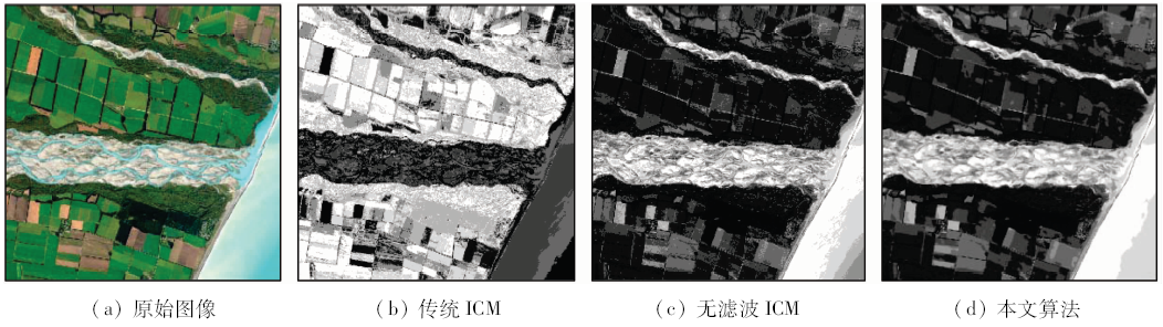
Abstract The traditional iterated conditional model(ICM)algorithm, when applied to remote sensing image segmentation, is easy to show discrete patches and isolated points. In view of this phenomenon, an improved ICM remote sensing segmentation algorithm is proposed which is based on Markov random field(MRF). First, the robust bilateral filter(BF)which is efficient in preserving edges and denoising was merged and used for the preprocessing of the remote sensing image, and then the Otsu algorithm was applied to obtaining the initial clusters. The algorithm could overcome some problems that occurred in the traditional K-means algorithm such as the inability in determining the number of clusters, difficulty in controlling algorithm complexities, and appearance of overlapping in the segmented regions. Next, the MRF was used to describe the pixel spatial correlation forming ICM remote sensing image segmentation algorithm with contextual information. By using remote sensing image data validation, the approach proposed in this paper realizes more reliable segmentation results in comparison with the traditional ICM algorithm.
|
| Keywords
iterated conditional model(ICM)
Markov random field(MRF)
Otsu
bilateral filter(BF)
image segmentation
|
|
|
|
Issue Date: 10 September 2018
|
|
|
| [1] |
Zheng C, Zhang Y, Wang L G . Multilayer semantic segmentation of remote-sensing imagery using a hybrid object-based Markov random field model[J]. International Journal of Remote Sensing, 2016,37(23):5505-5532.
doi: 10.1080/01431161.2016.1244364
url: https://www.tandfonline.com/doi/full/10.1080/01431161.2016.1244364
|
| [2] |
Gaetano R, Masi G, Poggi G , et al. Marker-controlled watershed-based segmentation of multiresolution remote sensing images[J]. IEEE Transactions on Geoscience and Remote Sensing, 2015,53(6):2987-3004.
doi: 10.1109/TGRS.2014.2367129
url: http://ieeexplore.ieee.org/document/6980061/
|
| [3] |
梁若飞, 杨风暴, 王毅敏 , 等. 一种类矩形引导的玉米田遥感图像分割算法[J]. 国土资源遥感, 2016,28(3):53-59.doi: 10.6046/gtzyyg.2016.03.09.
doi: 10.6046/gtzyyg.2016.03.09
url: http://d.wanfangdata.com.cn/Periodical/gtzyyg201603009
|
| [3] |
Liang R F, Yang F B, Wang Y M , et al. A near-rectangle guided segmentation method for remote sensing images of corn field areas[J]. Remote Sensing for Land and Resources, 2016,28(3):53-59.doi: 10.6046/gtzyyg.2016.03.09.
|
| [4] |
鲁恒, 付萧, 刘超 , 等. 基于无人机影像的快速分割方法[J]. 国土资源遥感, 2016,28(2):72-78.doi: 10.6046/gtzyyg.2016.02.12.
doi: 10.6046/gtzyyg.2016.02.12
|
| [4] |
Lu H, Fu X, Liu C , et al. Study of method for fast segmentation based on UAV image[J]. Remote Sensing for Land and Resources, 2016,28(2):72-78.doi: 10.6046/gtzyyg.2016.02.12.
|
| [5] |
Kato Z, Zerubia J . Markov Random Fields in Image Segmentation[M]. Hanover:Now Publisher, 2012.
|
| [6] |
Liu G Y, Wang L G, Hong L . Supervised image segmentation using region-level TS-MRF models[J]. Journal of Computational Information Systems, 2013,9(23):9533-9540.
doi: 10.12733/jcis7826
url: http://www.researchgate.net/publication/282266224_Supervised_image_segmentation_using_region-level_TS-MRF_models
|
| [7] |
Doulgeris A P . An automatic u-distribution and Markov random field segmentation algorithm for PolSAR images[J]. IEEE Transactions on Geoscience and Remote Sensing, 2015,53(4):1819-1827.
doi: 10.1109/TGRS.2014.2349575
url: http://ieeexplore.ieee.org/document/6891291/
|
| [8] |
Rother C, Kolmogorov V, Blake A . "Grabcut":Interactive foreground extraction using iterated graph cuts[J]. ACM Transactions on Graphics(TOG), 2004,23(3):309-314.
doi: 10.1145/1015706
url: http://portal.acm.org/citation.cfm?doid=1015706
|
| [9] |
Tso B C K, Mather P M . Classification of multisource remote sensing imagery using a genetic algorithm and Markov random fields[J]. IEEE Transactions on Geoscience and Remote Sensing, 1999,37(3):1255-1260.
doi: 10.1109/36.763284
url: http://ieeexplore.ieee.org/document/763284/
|
| [10] |
Chou P B, Brown C M . The theory and practice of Bayesian image labeling[J]. International Journal of Computer Vision, 1990,4(3):185-210.
doi: 10.1007/BF00054995
url: http://link.springer.com/10.1007/BF00054995
|
| [11] |
侯一民, 郭雷 . 一种基于马尔可夫随机场的SAR图像分割新方法[J]. 电子与信息学报, 2007,29(5):1069-1072.
doi: 10.3724/SP.J.1146.2005.01359
url: http://d.wanfangdata.com.cn/Periodical/dzkxxk200705014
|
| [11] |
Hou Y M, Guo L . A novel SAR image segmentation method based on Markov random field[J]. Journal of Electronics & Information Technology, 2007,29(5):1069-1072.
|
| [12] |
杨红磊, 彭军还 . 基于马尔可夫随机场的模糊c-均值遥感影像分类[J]. 测绘学报, 2012,41(2):213-218.
|
| [12] |
Yang H L, Peng J H . Remote sensing classification based on Markov random field and fuzzy c-means clustering[J]. Acta Geodaeticaet Cartographica Sinica, 2012,41(2):213-218.
|
| [13] |
谢昭, 谢年群, 姚婷婷 . 一种图像空间下的ICM聚类方法[J]. 电路与系统学报, 2013,18(2):277-283,290.
doi: 10.3969/j.issn.1007-0249.2013.02.047
url: http://d.wanfangdata.com.cn/Periodical/dlyxtxb201302047
|
| [13] |
Xie Z, Xie N Q, Yao T T . An ICM clustering method based on image space[J]. Journal of Circuits and Systems, 2013,18(2):277-283,290.
|
| [14] |
Baumgartner J, Gimenez J, Scavuzzo M , et al. A new approach to segmentation of multispectral remote sensing images based on MRF[J]. IEEE Geoscience and Remote Sensing Letters, 2015,12(8):1720-1724.
doi: 10.1109/LGRS.2015.2421736
url: http://ieeexplore.ieee.org/document/7098347/
|
| [15] |
刘国英, 马国锐, 王雷光 , 等. 基于Markov随机场的小波域图像建模及分割——Matlab环境[M]. 北京: 科学出版社, 2010.
|
| [15] |
Liu G Y, Ma G R, Wang L G , et al. Image Modeling and Segmentation of Wavelet Domain Based on Markov Random Field[M]. Beijing: Science Press, 2010.
|
| [16] |
Geman S, Geman D .Stochastic relaxation, Gibbs distributions, and the Bayesian restoration of images[J].IEEE Transactions on Pattern Analysis and Machine Intelligence, 1984, PAMI-6(6):721-741.
doi: 10.1080/02664769300000058
pmid: 22499653
url: http://europepmc.org/abstract/med/22499653
|
| [17] |
Sarkar A, Biswas M K, Kartikeyan B , et al. A MRF model-based segmentation approach to classification for multispectral imagery[J]. IEEE Transactions on Geoscience and Remote Sensing, 2002,40(5):1102-1113.
doi: 10.1109/TGRS.2002.1010897
url: http://ieeexplore.ieee.org/document/1010897/
|
| [18] |
Li S Z . Markov Random Field Modeling in Image Analysis[M]. 3rd ed.London:Springer, 2009.
|
| [19] |
Berthod M, Kato Z, Yu S , et al. Bayesian image classification using Markov random fields[J]. Image and Vision Computing, 1996,14(4):285-295.
doi: 10.1007/978-94-017-2217-9_45
url: http://linkinghub.elsevier.com/retrieve/pii/0262885695010726
|
| [20] |
李旭超, 朱善安 . 图像分割中的马尔可夫随机场方法综述[J]. 中国图象图形学报, 2007,12(5):789-798.
doi: 10.11834/jig.20070504
|
| [20] |
Li X C, Zhu S A . A survey of the Markov random field method for image segmentation[J]. Journal of Image and Graphics, 2007,12(5):789-798.
|
| [21] |
Duda R O, Hart P E, Stork D G. 模式分类[M]. 李宏东, 姚天翔译.2版.北京:机械工业出版社, 2003.
|
| [21] |
Duda R O, Hart P E, Stork D G. Pattern Classification[M]. Translated by Li H D, Yao T X.2nd ed.Beijing:China Machine Press, 2003.
|
|
Viewed |
|
|
|
Full text
|
|
|
|
|
Abstract
|
|
|
|
|
Cited |
|
|
|
|
| |
Shared |
|
|
|
|
| |
Discussed |
|
|
|
|
 2018,
Vol. 30
2018,
Vol. 30