| Orginal Article |
|
 |
|

|
|
|
The method for detecting forest cover change in GF-1images by using KPCA |
Lingyu YIN1( ), Xianlin QIN1(), Guifen SUN1, Shuchao LIU1, Xiaofeng ZU1, Xiaozhong CHEN2 ), Xianlin QIN1(), Guifen SUN1, Shuchao LIU1, Xiaofeng ZU1, Xiaozhong CHEN2 |
1. Research Institute of Forest Resource Information Technique, Chinese Academy of Forestry, Beijing 100091, China
2. ForestInformation Center of Sichuan Province, Chengdu 610081, China |
|
|
|
|
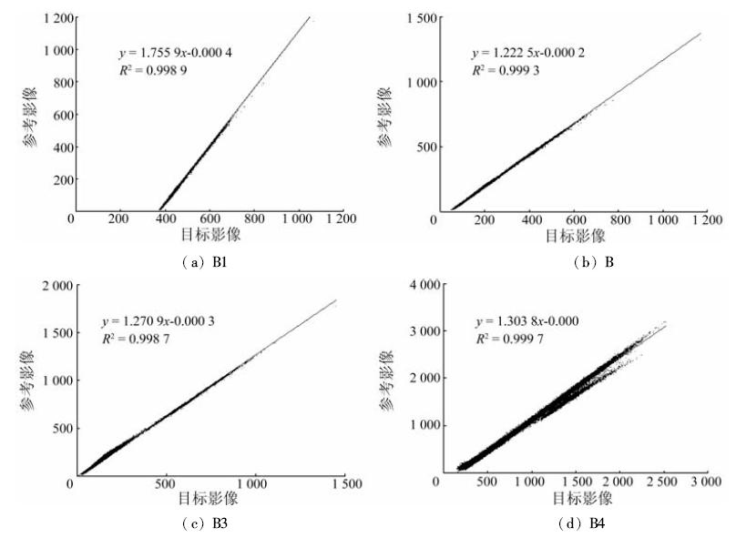
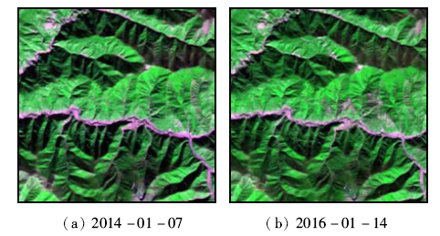
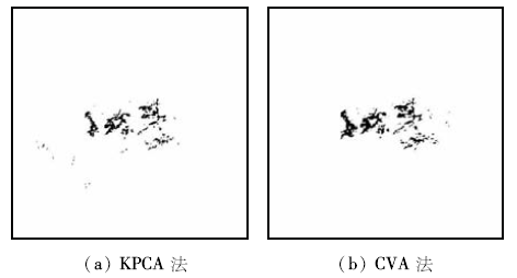
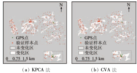
Abstract In order to study the methods for forest cover change monitoring by using GF-1 images, the Yajiang County in Sichuan Province was selected as the research area to extract the information of forest coverage based on the two GF-1 WFV data. Firstly, the data were normalized by using the iteration re-weight multivariate alteration detection(IR-MAD)method. The two images were transformed by kernel principal component analysis(KPCA)method, and formed differencing image. Then, the changed area was extracted using the method of maximum between class variances(OTSU)for automatic threshold selection. Finally, the change detection results were validated using OTSU with the field sample data, and the extracted results were verified by way of precision test, and comparatively analyzed with the change vector analysis(CVA). The research results show that the overall accuracy of the two change detection methods is higher than 80%, and the overall accuracy of the KPCA method is 89.27%. The user precision of unchanged area is 93.88%, and the user's accuracy of changed area is 80.28%. The accuracy of the KPCA method is better than that of the algorithm based on the traditional CVA method. It is shown that, after the data transformation, KPCA algorithm can reduce the correlation between the variables and enhance the signal to noise ratio of the image, thus improving the recognition accuracy for the changed area.
|
| Keywords
GF-1
iteration re-weight multivariate alteration detection(IR-MAD)
kernel principal component analysis(KPCA)
method of maximum between class variance(OTSU)
|
|
|
|
Issue Date: 08 February 2018
|
|
|
| [1] |
Fazakas Z,Nilsson M,Olsson H. Regional forest biomass and wood volume estimation using satellite data and ancillary data[J].Agricultural and Forest Meteorology,1999,98-99:417-425.
|
| [2] |
李俊明,邢艳秋,杨超,等.基于环境与灾害监测预报小卫星的树种识别[J].东北林业大学学报,2013,41(11):41-45,50.
|
| [2] |
Li J M,Xing Y Q,Yang C,et al.Forest type identification based on hyperspectral remote sensing image of environment and disaster monito-ring satellite[J].Journal of Northeast Forestry University,2013,41(11):41-45,50.
|
| [3] |
吴雪琼,覃先林,周汝良,等.森林覆盖变化遥感监测方法研究进展[J]. 林业资源管理, 2010(4):82-87.
|
| [3] |
Wu X Q,Qin X L,Zhou R L,et al.Progress of study on forest cover change detection by using remote sensing technique[J]. Forest Resources Management, 2010(4):82-87.
|
| [4] |
钟家强,王润生.基于独立成分分析的多时相遥感图像变化检测[J].电子与信息学报,2006,28(6):994-998.
|
| [4] |
Zhong J Q,Wang R S.Multitemporal remote sensing images change detection based on ICA[J].Journal of Electronics & Information Technology,2006,28(6):994-998.
|
| [5] |
李世明,王志慧,韩学文,等.森林资源变化遥感监测技术研究进展[J].北京林业大学学报,2011,33(3):132-138.
|
| [5] |
Li S M,Wang Z H,Han X W,et al.Overview of forest resources change detection methods using remote sensing techniques[J].Journal of Beijing Forestry University,2011,33(3):132-138.
|
| [6] |
覃先林,陈尔学,李增元,等.基于MODIS数据的森林覆盖变化监测方法研究[J].遥感技术与应用,2006,21(3):178-183.
|
| [6] |
Qin X L,Chen E X,LI Z Y,et al.Forest cover change monitoring using MODIS data[J].Remote Sensing Technology and Application,2006,21(3):178-183.
|
| [7] |
Platt R V,Schoennagel T.An object-oriented approach to assessing changes in tree cover in the Colorado front range 1938―1999[J].Forest Ecology and Management,2009,258(7):1342-1349.
|
| [8] |
Hese S,Schmullius C. Forest cover change in Siberia-results from the Siberia-II project[EB/OL].(2011-01-11)[2016-08-01]..
url: http://www.Ecognition.com/document/forest-cover-changesiberia-results-siberia-ii-project
|
| [9] |
Collins J B,Woodcock C E.An assessment of several linear change detection techniques for mapping forest mortality using multitemporal Landsat TM data[J].Remote Sensing of Environment,1996,56(1):66-77.
|
| [10] |
黄维,黄进良,王立辉,等.基于PCA的变化向量分析法遥感影像变化检测[J].国土资源遥感,2016,28(1):22-27.doi:10.6046/gtzyyg.2016.01.04.
|
| [10] |
Huang W,Huang J L,Wang L H,et al.Remote sensing image change detection based on change vector analysis of PCA component[J].Remote Sensing for Land and Resources,2016,28(1):22-27.doi:10.6046/gtzyyg.2016.01.04.
|
| [11] |
刚慧龙. 基于IR-MAD算法的多元遥感影像变化检测方法研究[D].青岛:山东科技大学,2014.
|
| [11] |
Gang H L.The Study of Change Detection Method for Multivariate Remote Sensing Data based on the IR-MAD Algorithm[D].Qingdao:Shandong University of Science and Technology,2014.
|
| [12] |
沈照庆,陶建斌.基于模糊核主成分分析的高光谱遥感影像特征提取研究[J].国土资源遥感,2009,21(3):41-44,99.doi:10.6046/gtzyyg.2009.03.08.
|
| [12] |
Shen Z Q,Tao J B.Hyperspectral remote sensing image feature extraction based on fuzzy kernel principal component analysis[J].Remote Sensing for Land and Resources,2009,21(3):41-44,99.doi:10.6046/gtzyyg.2009.03.08.
|
| [13] |
杨帆,马洁.基于KPCA数据重构的参数优化方法[J].北京信息科技大学学报,2014,29(6):46-50.
|
| [13] |
Yang F,Ma J.Parameter optimization method based on KPCA data reconstruction[J].Journal of Beijing Information Science and Technology University,2014,29(6):46-50.
|
| [14] |
王国胜. 核函数的性质及其构造方法[J].计算机科学,2006,33(6):172-174,178.
|
| [14] |
Wang G S.Properties and construction methods of kernel in support vector machine[J].Computer Science,2006,33(6):172-174,178.
|
| [15] |
Malila W A.Change vector analysis:An approach for detecting forest changes with Landsat[C]//Proceedings of Sixth International Symposium on Machine Processing of Remotely Sensed Data.West Lafayette,Indiana:Purdue University,1980.
|
| [16] |
林克正,班守峰,张玉双.一种基于变化向量分析的变化检测方法[J].哈尔滨理工大学学报,2008,13(4):47-49.
|
| [16] |
Lin K Z,Ban S F,Zhang Y S.A change detection based on change vector analysis[J].Journal of Harbin University of Science and Technology,2008,13(4):47-49.
|
| [17] |
魏伟一. 基于小波域灰度拉伸的Ostu图像分割[J].西北师范大学学报(自然科学版),2009,45(6):46-48.
|
| [17] |
Wei W Y.New Ostu image segmentation based on intensity stretching on DWT fields[J].Journal of Northwest Normal University(Natural Science),2009,45(6):46-48.
|
| [18] |
蔡燕伟,崔红霞.基于彩色空间的二维OSTU的图像分割算法[J].电子设计工程,2014,22(5):131-133.
|
| [18] |
Cai Y W,Cui H X.Image segmentation algorithm based on two-dimensional OSTU of color space[J].Electronic Design Engineering,2014,22(5):131-133.
|
|
Viewed |
|
|
|
Full text
|
|
|
|
|
Abstract
|
|
|
|
|
Cited |
|
|
|
|
| |
Shared |
|
|
|
|
| |
Discussed |
|
|
|
|
 2018,
Vol. 30
2018,
Vol. 30