|
|
 |
|

|
|
|
A study of the disturbance to mangrove forests in Dongzhaigang, Hainan based on LandTrendr |
YU Sen1,2( ), JIA Mingming2(), CHEN Gao2, LU Yingying2,3, LI Yi1,2, ZHANG Bochun1,2, LU Chunyan4, LI Huiying5 ), JIA Mingming2(), CHEN Gao2, LU Yingying2,3, LI Yi1,2, ZHANG Bochun1,2, LU Chunyan4, LI Huiying5 |
1. School of Surveying, Mapping and Exploration Engineering, Jilin Jianzhu University, Changchun 130118, China
2. Key Laboratory of Wetland Ecology and Environment, Northeast Institute of Geography and Agroecology, Chinese Academy of Sciences, Changchuan 130102, China
3. Changchun New District Beihu Yingcai School, Changchun 130000, China
4. College of Computer and Information Sciences, Fujian Agriculture and Forestry University, Fuzhou 350002, China
5. School of Environmental and Municipal Engineering, Qingdao University of Technology, Qingdao 266520, China |
|
|
|
|
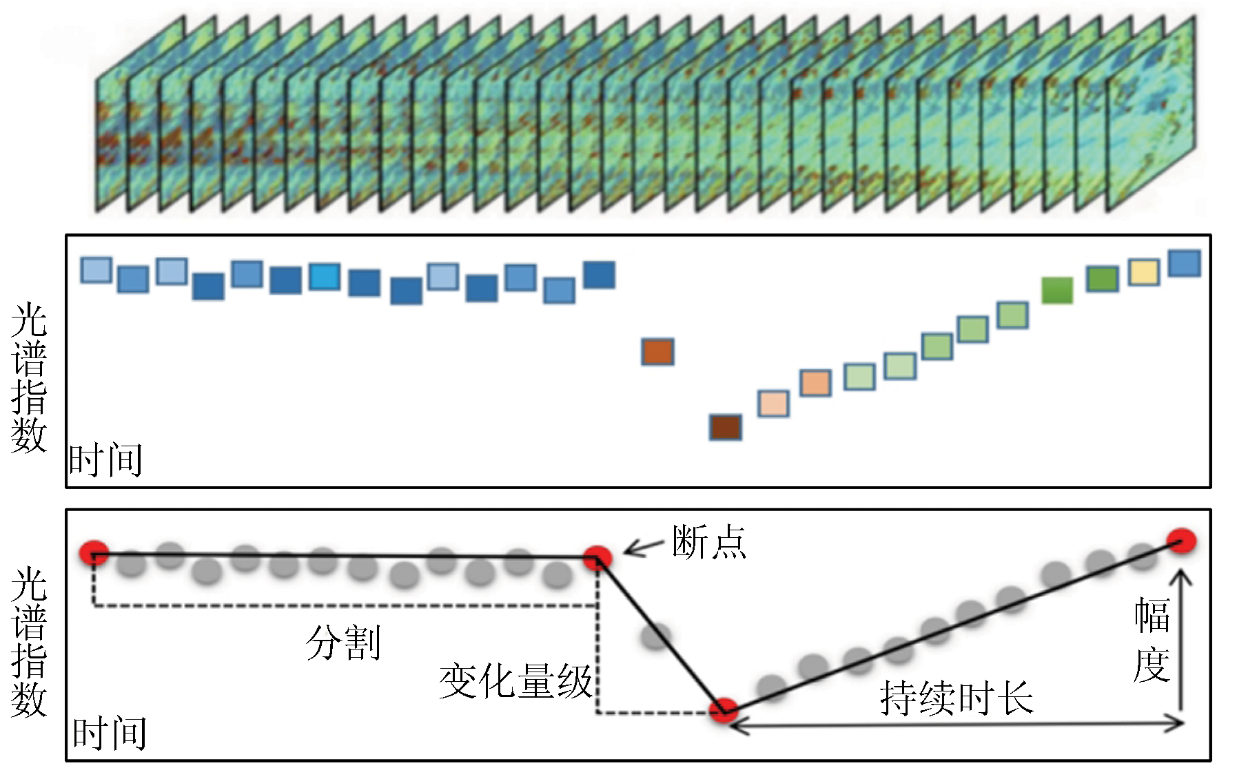
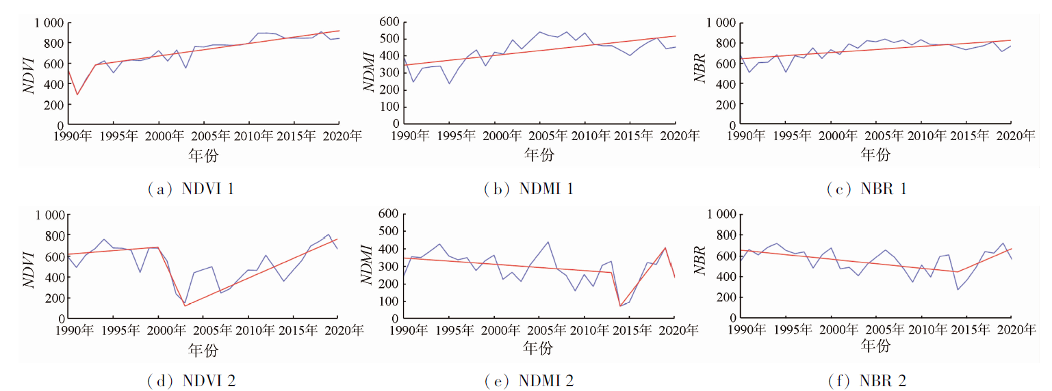
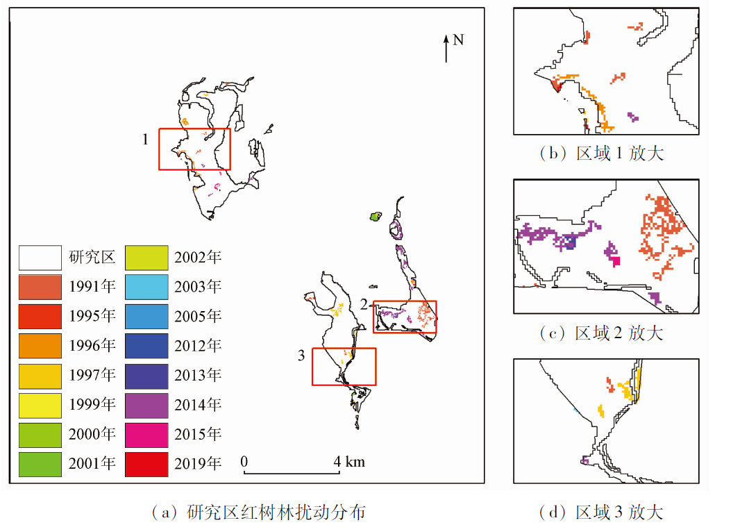
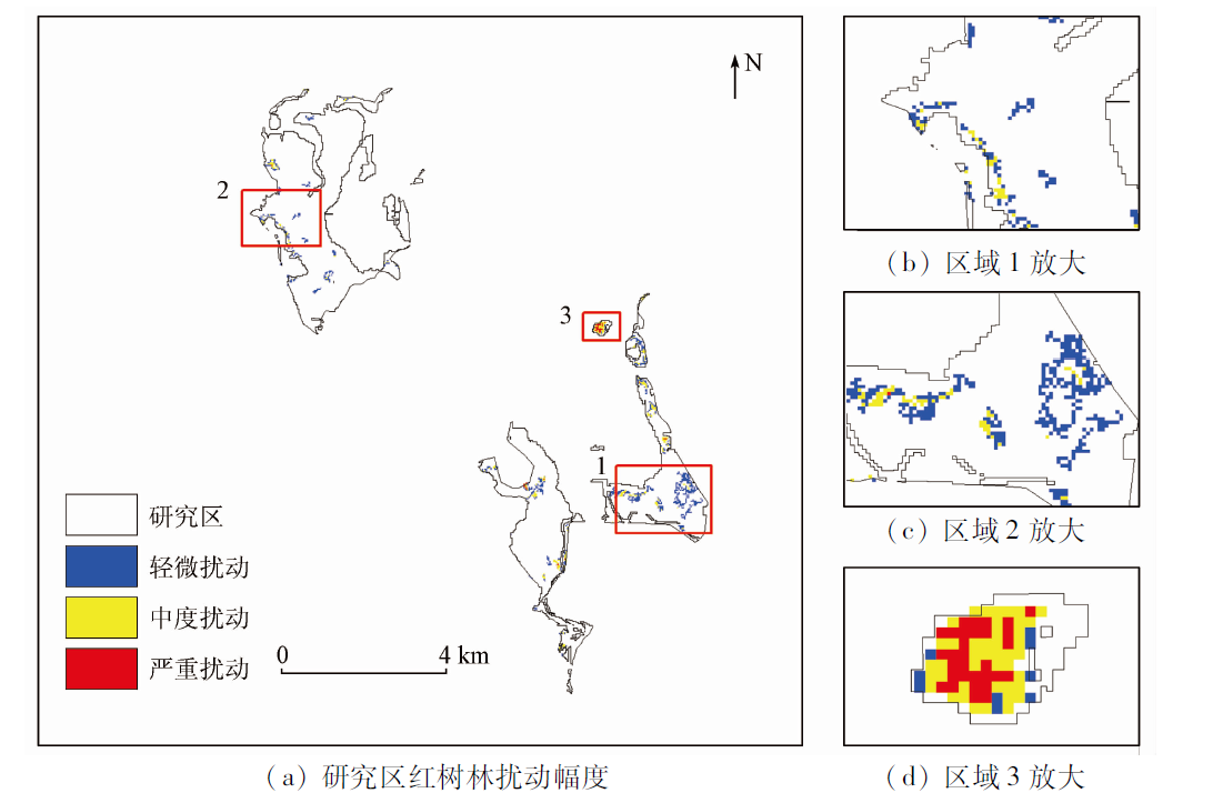
Abstract With the rapid socio-economic development and the increasing demand for natural resources in China, the protection of natural reserves is facing increasing difficulties. The remote sensing-based research on monitoring the disturbance and the restoration of mangrove forests through time series analysis is still in its initial stage. Moreover, time series algorithms are highly complex. Based on the LandTrendr time segmentation algorithm of Google Earth Engine (GEE) and the Landsat image time-series data, this study investigated the disturbance to mangrove forests in the Dongzhaigang Mangrove Nature Reserve during 1990—2020. The results are as follows: ① A total of 42.39 hm2 of mangrove forests were disturbed during 1990—2020, among which the largest disturbance area of 12.78 hm2 occurred in 2014; ② During 1990—2020, minor, moderate, and severe disturbances accounted for 65.39%, 30.78%, and 3.83%, respectively; ③ The overall identification accuracy of the pixels of mangrove forests subject to changes was 89.50%, and the overall detection accuracy of years witnessing disturbance was 88%, with a Kappa coefficient of 0.79. This study analyzed the years and areas of the disturbance to mangrove forests in the Dongzhaigang Mangrove Nature Reserve over 30 years based on LandTrendr. Moreover, this study analyzed the disturbance factors according to the actual situation and concluded that human activities are the main disturbance factor, followed by natural factors, such as diseases, pests, and extreme weather events. This study will provide a scientific basis and a decision reference for the management of the mangrove forest reserve.
|
| Keywords
Dongzhaigang
mangrove forest
Google Earth Engine (GEE)
LandTrendr
Landsat
|
|
|
|
Issue Date: 07 July 2023
|
|
|
| [1] |
张乔民, 于红兵, 陈欣树, 等. 红树林生长带与潮汐水位关系的研究[J]. 生态学报, 1997, 17:258-265.
|
| [1] |
Zhang Q M, Yu H B, Chen X S, et al. The relationship between mangrove zone on tidal flats and tidal levels[J]. Acta Ecologica Sinica, 1997, 17:258-265.
|
| [2] |
林鹏. 中国红树林生态系统研究[M]. 北京: 科学出版社, 1997.
|
| [2] |
Lin P. Study of China’s mangrove ecosystem[M]. Beijing: Science Press, 1997.
|
| [3] |
林鹏, 张宜辉, 杨志伟. 厦门海岸红树林的保护与生态恢复[J]. 厦门大学学报(自然科学版), 2005, 44:1-6.
|
| [3] |
Lin P, Zhang Y H, Yang Z W. Protection and restoration of mangroves along the coast of Xiamen[J]. Journal of Xiamen University (Natural Science Edition), 2005, 44:1-6.
|
| [4] |
Glaser M. Interrelations between mangrove ecosystem,local economy and social sustainability in Cacte Estuary,North Brazil[J]. Wetlands and Management, 2003, 11(4):265-272.
|
| [5] |
徐慧鹏, 刘涛, 张建兵. 红树林碳埋藏过程对海平面上升、气候变化和人类活动的响应[J]. 广西科学, 2020, 27:84-90.
|
| [5] |
Xue H P, Liu T, Zhang J B. Response of carbon sequestration in mangroves to sea level rise,climate change and human activities[J]. Guangxi Science, 2020, 27:84-90.
|
| [6] |
但新球, 廖宝文, 吴照柏, 等. 中国红树林湿地资源、保护现状和主要威胁[J]. 生态环境学报, 2016, 25:1237-1243.
doi: 10.16258/j.cnki.1674-5906.2016.07.021
|
| [6] |
Dan X Q, Liao B W, Wu Z B, et al. Resources,conservation status and main threats of mangrove wetlands in China[J]. Ecology and Environmental Sciences, 2016, 25:1237-1243.
|
| [7] |
贾明明. 1973—2013年中国红树林动态变化遥感分析[D]. 长春: 中国科学院研究生院(东北地理与农业生态研究所), 2014.
|
| [7] |
Jia M M. Remote sensing analysis of China’s mangrove forests dynamics during 1973 to 2013[D]. Changchun: University of Chinese Academy of Science(Northeast Institute of Geography and Agroecology), 2014.
|
| [8] |
林益明, 林鹏. 中国红树林生态系统的植物种类、多样性、功能及其保护[J]. 海洋湖沼通报, 2001(3):8-16.
|
| [8] |
Lin Y M, Lin P. Plant species,diversity,functions and protection of mangrove ecosystems in China[J]. Bulletin of Marine Limnology, 2001(3):8-16.
|
| [9] |
Son N, Chen C, Chang N, et al. Mangrove mapping and change detection in Ca Mau Peninsula,Vietnam,using Landsat data and object-based image analysis[J]. IEEE Journal of Selected Topics in Applied Earth Observations and Remote Sensing, 2015, 8(2):503-510.
doi: 10.1109/JSTARS.4609443
url: https://ieeexplore.ieee.org/xpl/RecentIssue.jsp?punumber=4609443
|
| [10] |
李伟, 崔丽娟, 张曼胤, 等. 遥感技术在红树林湿地研究中的应用述评[J]. 林业调查规划, 2008, 33(5):1-7.
|
| [10] |
Li W, Cui L J, Zhang M Y, et al. Review of the application of remote sensing technology in mangrove wetland research[J]. Forestry Survey Planning, 2008, 33(5):1-7.
|
| [11] |
杨辰, 沈润平. 森林扰动遥感监测进展[J]. 国土资源遥感, 2015, 27(1):1-8.doi:10.6046/gtzyyg.2015.01.01.
doi: 10.6046/gtzyyg.2015.01.01
|
| [11] |
Yang C, Shen R P. Progess in the study of forest-disturbance by remote sensing[J]. Remote Sensing for Land and Resources, 2015, 27(1):1-8.doi:10.6046/gtzyyg.2015.01.01.
doi: 10.6046/gtzyyg.2015.01.01
|
| [12] |
Verbesselt J, Hyndman R, Newnham G, et al. Detecting trend and seasonal changes in satellite image time series[J]. Remote Sensing of Environment, 2010, 114(1):106-115.
doi: 10.1016/j.rse.2009.08.014
url: https://linkinghub.elsevier.com/retrieve/pii/S003442570900265X
|
| [13] |
Kennedy R E, Yang Z, Cohen W B, et al. Spatial and temporal patterns of forest disturbance and regrowth within the area of the Northwest Forest Plan[J]. Remote Sensing of Environment, 2012, 122:117-133.
doi: 10.1016/j.rse.2011.09.024
url: https://linkinghub.elsevier.com/retrieve/pii/S0034425712000417
|
| [14] |
Zhu Z, Woodcock C E. Continuous change detection and classification of land cover using all available Landsat data[J]. Remote Sensing of Environment, 2014, 144:152-171.
doi: 10.1016/j.rse.2014.01.011
url: https://linkinghub.elsevier.com/retrieve/pii/S0034425714000248
|
| [15] |
Nardin W, Woodcock C E, Fagherazzi S. Bottom sediments affect Sonneratia mangrove forests in the prograding Mekong delta Vietnam[J]. Estuarine Coastal and Shelf Science, 2016, 177:60-70.
doi: 10.1016/j.ecss.2016.04.019
url: https://linkinghub.elsevier.com/retrieve/pii/S0272771416301421
|
| [16] |
Wang Y, Bonynge G, Nugranad J, et al. Remote sensing of mangrove change along the Tanzania coast[J]. Marine Geodesy, 2003, 26(1-2):35-48.
doi: 10.1080/01490410306708
url: http://www.tandfonline.com/doi/abs/10.1080/01490410306708
|
| [17] |
Gorelick N, Hancher M, Dixon M, et al. Google Earth Engine:Planetary-scale geospatial analysis for everyone[J]. Remote Sensing of Environment, 2017, 202:18-27.
doi: 10.1016/j.rse.2017.06.031
url: https://linkinghub.elsevier.com/retrieve/pii/S0034425717302900
|
| [18] |
王文卿, 王瑁. 中国红树林[M]. 北京: 科学出版社, 2007.
|
| [18] |
Wang W Q, Wang M. Chinese mangroves[M]. Beijing: Science Press, 2007.
|
| [19] |
Roy D P, Kovalskyy V, Zhang H K, et al. Characterization of Landsat7 to Landsat8 reflective wavelength and normalized difference vegetation index continuity[J]. Remote Sensing of Environment, 2016, 185:57-70.
doi: 10.1016/j.rse.2015.12.024
url: https://linkinghub.elsevier.com/retrieve/pii/S0034425715302455
|
| [20] |
贾明明, 王宗明, 毛德华, 等. 面向可持续发展目标的中国红树林近50年变化分析[J]. 科学通报, 2021, 66:3886-3901.
|
| [20] |
Jia M M, Wang Z M, Mao D H, et al. Spatial-temporal changes of China’s mangrove forests over the past 50 years:An analysis towards the Sustainable Development Goals (SDGs)[J]. Science Bulletin, 2021, 66:3886-3901.
|
| [21] |
Kennedy R E, Yang Z, Cohen W B. Detecting trends in forest disturbance and recovery using yearly Landsat time series:1.LandTrendr-temporal segmentation algorithms[J]. Remote Sensing of Environment, 2010, 114(12):2897-2910.
doi: 10.1016/j.rse.2010.07.008
url: https://linkinghub.elsevier.com/retrieve/pii/S0034425710002245
|
| [22] |
Kennedy R E, Yang Z Q, Gorelick N, et al. Implementation of the LandTrendr algorithm on Google Earth Engine[J]. Remote Sensing, 2018, 10(5):691.
doi: 10.3390/rs10050691
url: http://www.mdpi.com/2072-4292/10/5/691
|
| [23] |
Kennedy R E, Yang Z, Cohen W B, et al. Spatial and temporal patterns of forest disturbance and regrowth within the area of the Northwest Forest Plan[J]. Remote Sensing of Environment, 2012, 122:117-133.
doi: 10.1016/j.rse.2011.09.024
url: https://linkinghub.elsevier.com/retrieve/pii/S0034425712000417
|
| [24] |
Cohen W B, Goward S N. Landsat’s role in ecological applications of remote sensing[J]. Bioscience, 2004, 54(6):535-545.
doi: 10.1641/0006-3568(2004)054[0535:LRIEAO]2.0.CO;2
url: https://academic.oup.com/bioscience/article/54/6/535-545/294251
|
| [25] |
李云哲, 蒲凌海, 孙涛. 东寨港地区红树林湿地恢复的生态补偿效应评估[J]. 农村经济与科技, 2018, 29(24):3,10.
|
| [25] |
Li Y Z, Pu L H, Sun T. Assessment of the ecological compensation effect of mangrove wetland restoration in Dongzhaigang area[J]. Rural Economy and Technology, 2018, 29(24):3,10.
|
| [26] |
高春. 团水虱灾害在海南东寨港红树林的分布规律[D]. 海口: 海南师范大学, 2016.
|
| [26] |
Gao C. The distribution law of water lice disasters in the mangroves of Dongzhaigang,Hainan[D]. Haikou: Hainan Normal University, 2016.
|
| [27] |
邱明红, 王荣丽, 丁冬静, 等. 台风“威马逊”对东寨港红树林灾害程度影响因子分析[J]. 生态科学, 2016, 35:118-122.
|
| [27] |
Qiu M H, Wang R L, Ding D J, et al. Impact of “Rammasun” on mangrove communities in Dongzhaigang,Hainan[J]. Ecological Science, 2016, 35:118-122.
|
| [28] |
无庭天, 丁山, 陈宗铸, 等. 基于LUCC和景观格局变化的海南东寨港红树林湿地动态研究[J]. 林业科学研究, 2022, 33(5):154-162.
|
| [28] |
Wu T T, Ding S, Chen Z Z, et al. Dynamic research on mangrove wetlands in Dongzhaigang,Hainan based on LUCC and landscape pattern changes[J]. Forestry Research, 2022, 33(5):154-162.
|
| [29] |
颜秀花, 蔡榕硕, 郭海峡, 等. 气候变化背景下海南东寨港红树林生态系统的脆弱性评估[J]. 应用海洋学学报, 2019, 38:338-349.
|
| [29] |
Yan X H, Cai R S, Guo H X, et al. Vulnerability of Hainan Dongzhaigang mangrove ecosystem to the climate change[J]. Journal of Applied Oceanography, 2019, 38:338-349.
|
| [30] |
陈鹭真, 王文卿, 张宜辉, 等. 2008年南方低温对我国红树植物的破坏作用[J]. 植物生态学报, 2010, 34:186-194.
doi: 10.3773/j.issn.1005-264x.2010.02.010
|
| [30] |
Chen L Z, Wang W Q, Zhang Y H, et al. Damage to mangroves from extreme cold in early 2008 in southern China[J]. Journal of Integrative Plant Biology, 2010, 34:186-194.
|
| [31] |
林华文, 林卫海. 团水虱对东寨港红树林的危害及防治对策[J]. 热带林业, 2013 (4):35-36.
|
| [31] |
Lin H W, Lin W H. The damages and controlling strategies of Sphaeroma in Dongzhaigang mangroves[J]. Tropical Forestry, 2013 (4):35-36.
|
| [32] |
王胤, 左平, 黄仲琪, 等. 海南东寨港红树林湿地面积变化及其驱动力分析[J]. 四川环境, 2006, 25:44-49.
|
| [32] |
Wang Y, Zuo P, Huang Z Q, et al. Study of the change of the mangrove wetland ecosystem and driving forces in Dongzhaigang[J]. Sichuan Environment, 2006, 25:44-49.
|
| [33] |
韩淑梅. 海南东寨港红树林景观格局动态及其驱动力研究[D]. 北京: 北京林业大学, 2012.
|
| [33] |
Han S M. Study on landscape pattern dynamics and driving forces in mangrove wetlands of Dongzhaigang Harbour,Hainan Province[D]. Beijing: Beijing Forestry University, 2012.
|
| [34] |
祝阁, 钟才荣, 李诗川, 等. 海南东寨港集约化海鸭养殖对红树林的影响[C]// 中国生态学学会红树林学组执委会.中国第五届红树林学术会议论文摘要集.温州, 2011.
|
| [34] |
Zhu G, Zhong C R, Li S C, et al. Influence of intensive sea duck farming on mangroves in Dongzhai Port,Hainan[C]// Executive Committee of Mangrove Science Group of Chinese Ecological Society.Summary Collection of the Fifth Chinese Mangrove Academic Conference.Wenzhou, 2011.
|
| [35] |
Feller I C, Whigham D F, McKee K L, et al. Nitrogen limitation of growth and nutrient dynamics in a disturbed mangrove forest,Indian River Lagoon,Florida[J]. Oecoligia, 2003, 134:405-414.
|
| [36] |
Elison J C. Impacts of sediment burial on mangroves[J]. Marine Pollution Bulletion, 1998, 37:420-426.
|
|
Viewed |
|
|
|
Full text
|
|
|
|
|
Abstract
|
|
|
|
|
Cited |
|
|
|
|
| |
Shared |
|
|
|
|
| |
Discussed |
|
|
|
|
 2023,
Vol. 35
2023,
Vol. 35