|
|
 |
|

|
|
|
Correlation analysis between nonmetallic mines for building materials and social economy in the Tibet Autonomous Region |
WANG Hao( ), LIU Cai, CHEN Li(), YANG Jinzhong, WEN Jing, SUN Yaqin, AN Na, ZHOU Yingjie, SHAO Zhitao ), LIU Cai, CHEN Li(), YANG Jinzhong, WEN Jing, SUN Yaqin, AN Na, ZHOU Yingjie, SHAO Zhitao |
| China Aero Geophysical Survey & Remote Sensing Center for Natural Resources, Beijing 100083, China |
|
|
|
|
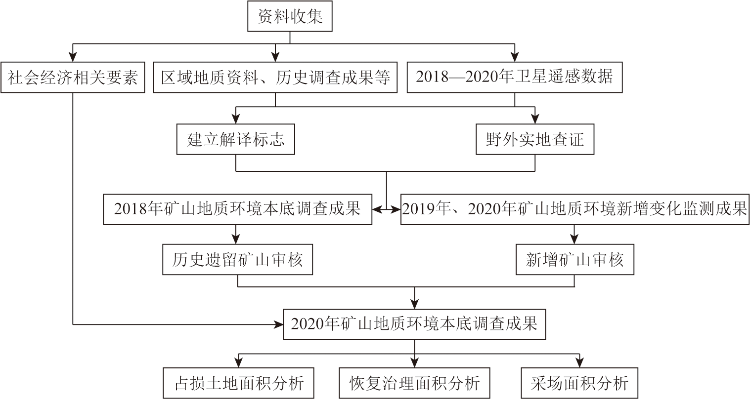
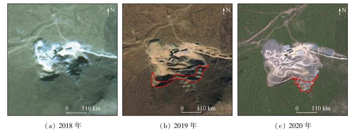
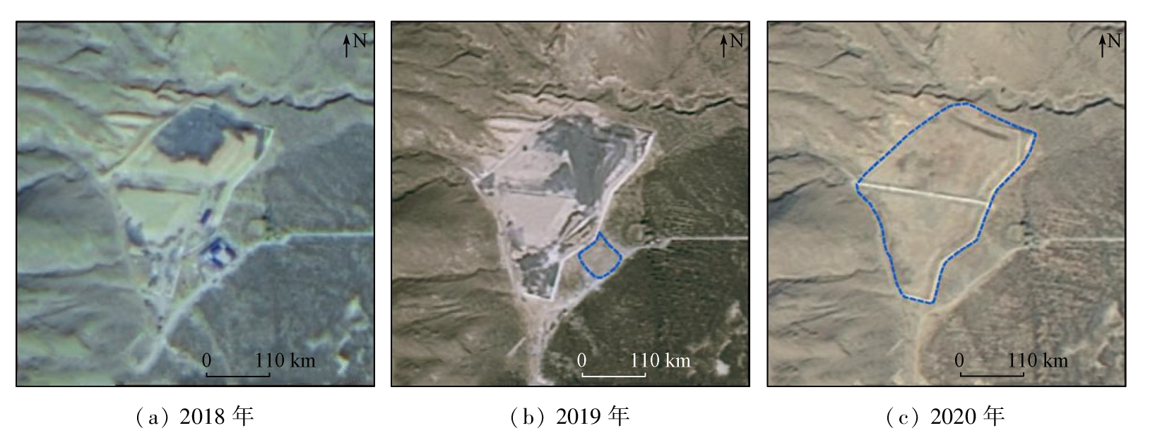
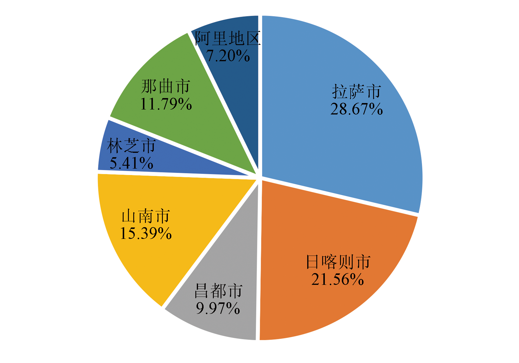
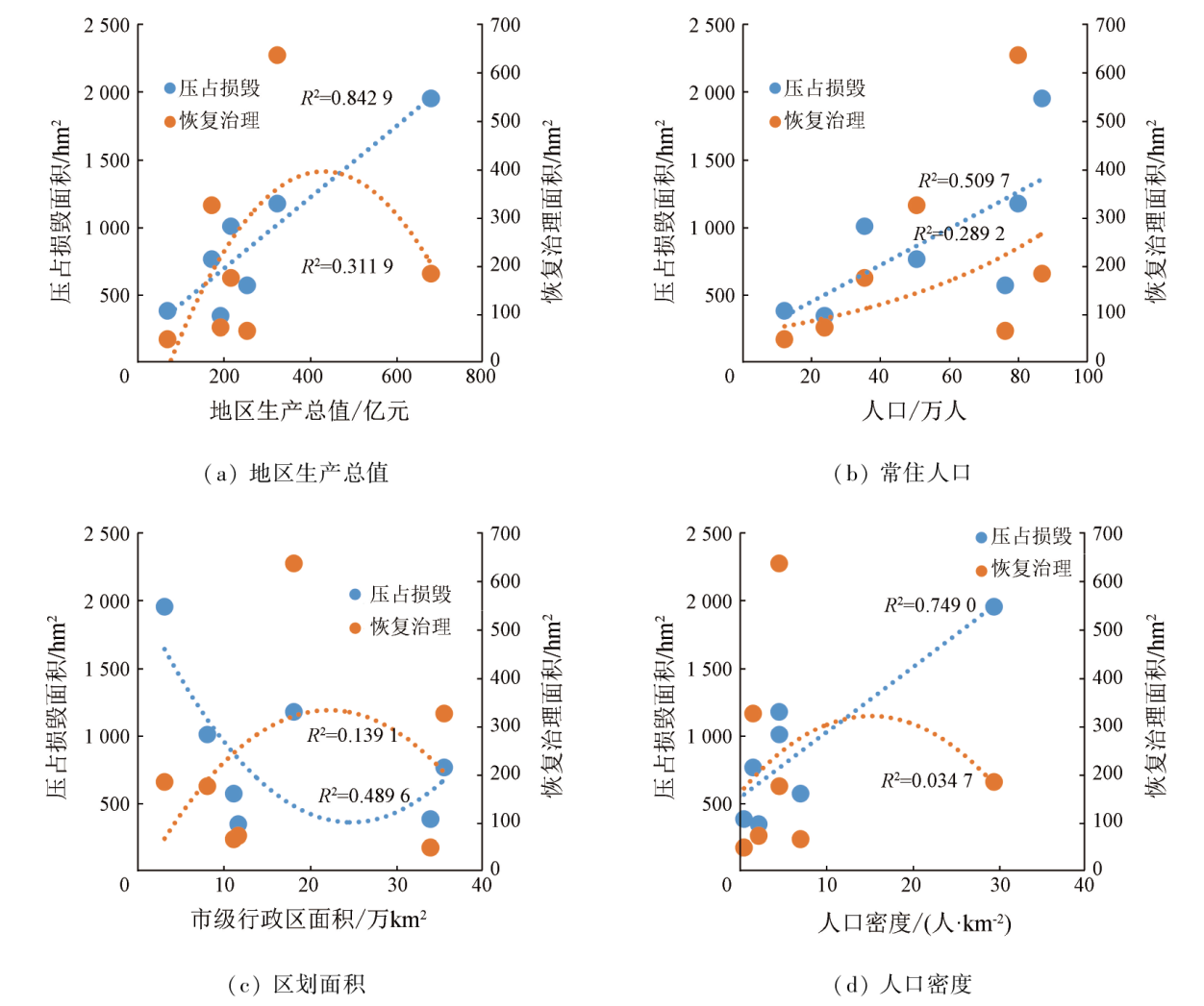
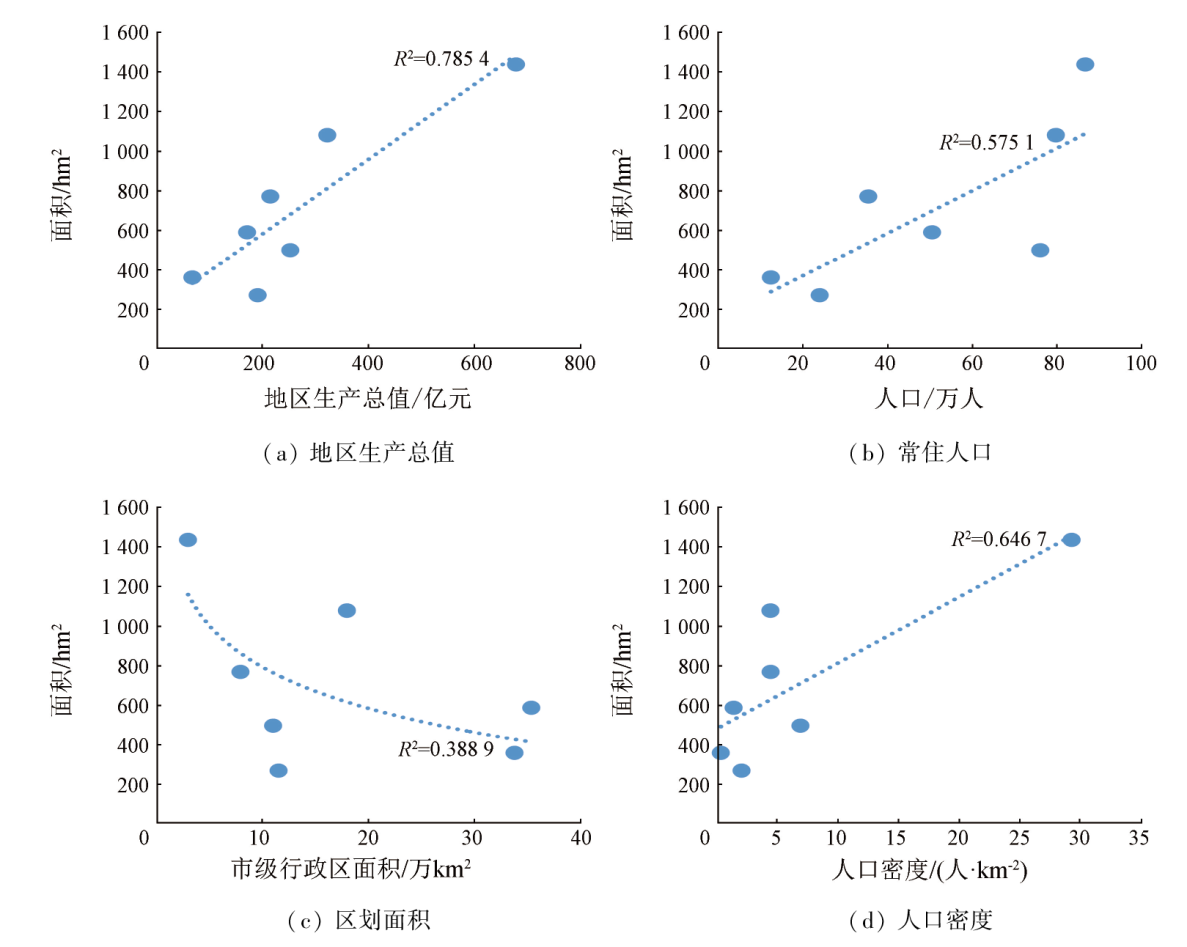
Abstract Based on the survey and monitoring results obtained using satellite remote sensing technology, this study investigated the nonmetallic mines for building materials under the jurisdiction of municipal administrative units in the Tibet Autonomous Region. It conducted an exploratory analysis by correlating the land damage, the restoration and control of mine environments, and the damage scales of mining areas in these mines with typical socio-economic factors like gross regional product (GRP), population, zoning area, and population density. The results show that higher GRP or population density is associated with a larger mining scale of nonmetallic mineral resources for building materials. This conclusion provides a research basis for predicting the mining scales of nonmetallic mines for building materials in certain regions in China’s western provinces and achieving harmonious development between the geological environments of such mines and socio-economic construction.
|
| Keywords
Tibet Autonomous Region
nonmetallic mines for building materials
social economy
correlation analysis
|
|
|
|
Issue Date: 03 September 2024
|
|
|
| [1] |
席蒙蒙, 陈朴. 环境友好社会进步经济发展:西藏生态现代化的三维审视[J]. 西藏研究, 2019(6):135-143.
|
| [1] |
Xi M M, Chen P. Environmental friendly,society progressive and economic development: A three-dimensional survey of Tibet’s ecological modernization[J]. Tibetan Studies, 2019 (6):135-143.
|
| [2] |
王昊, 杨金中, 安娜, 等. 矿山环境危害之浅见[J]. 华北自然资源, 2019(1):105-108.
|
| [2] |
Wang H, Yang J Z, An N, et al. Brief introduction of mine environmental hazard[J]. Huabei Natural Resources, 2019(1):105-108.
|
| [3] |
王海庆, 李丽, 许文佳, 等. 西藏生产矿山在用土地面积遥感调查与分析[J]. 矿产保护与利用, 2019, 39(5):146-150.
|
| [3] |
Wang H Q, Li L, Xu W J, et al. Survey and analysis about using land area of producing mines in Tibet based on remote sensing[J]. Conservation and Utilization of Mineral Resources, 2019, 39(5):146-150.
|
| [4] |
陈玲. 西藏矿山环境恢复治理现状遥感研究[J]. 矿产保护与利用, 2020, 40(1):132-137.
|
| [4] |
Chen L. Remote sensing study on the present situation of mining environment rehabilitation in Tibet[J]. Conservation and Utilization of Mineral Resources, 2020, 40(1):132-137.
|
| [5] |
王海庆, 陈玲. 西藏日喀则矿山环境恢复治理效果分析[J]. 矿业研究与开发, 2018, 38(10):111-114.
|
| [5] |
Wang H Q, Chen L. Effectiveness analysis on mine environment rehabilitation in Shigatse of Tibet[J]. Mining Research and Development, 2018, 38(10):111-114.
|
| [6] |
李丽, 汪洁, 汪劲, 等. 基于高分卫星遥感数据的金属矿开发现状及环境问题研究——以江西省德兴多金属矿集区为例[J]. 中国地质调查, 2016, 3(5):60-66.
|
| [6] |
Li L, Wang J, Wang J, et al. Study of metal mine development situation and environmental problems using high resolution satellite remote sensing data: A case of polymetallic ore concentration area in Dexing,Jiangxi Province[J]. Geological Survey of China, 2016, 3(5):60-66.
|
| [7] |
王昊, 安娜, 步凡, 等. 通天河沿自然保护分区矿山环境遥感调查[J]. 资源节约与环保, 2018(6):31,40.
|
| [7] |
Wang H, An N, Bu F, et al. Remote sensing investigation of mine environment in Tongtian Heyan Natural Reserve[J]. Resources Economization & Environmental Protection, 2018(6):31,40.
|
| [8] |
薛庆, 吴蔚, 李名松, 等. 遥感技术在辽宁省矿山环境监测中的应用[J]. 中国地质调查, 2016, 3(5):54-59.
|
| [8] |
Xue Q, Wu W, Li M S, et al. Application of remote sensing technology in mine environment monitoring in Liaoning Province[J]. Geological Survey of China, 2016, 3(5):54-59.
|
| [9] |
杨金中, 秦绪文, 聂洪峰, 等. 全国重点矿区矿山遥感监测综合研究[J]. 中国地质调查, 2015, 2(4):24-30.
|
| [9] |
Yang J Z, Qin X W, Nie H F, et al. Comprehensive research on remote sensing monitoring of the national concentration zones of the important mine[J]. Geological Survey of China, 2015, 2(4):24-30.
|
| [10] |
高俊华, 邹联学, 龙欢, 等. 基于遥感动态监测的吉林省矿山地质环境及生态修复变化特征分析[J]. 自然资源遥感, 2022, 34(3):240-248.doi:10.6046/zrzyyg.2021278.
|
| [10] |
Gao J H, Zou L X, Long H, et al. Analysis on characteristics of mine geological environment and ecological restoration changes in Jilin Province based on dynamic remote sensing monitoring[J]. Remote Sensing for Natural Resources, 2022, 34(3):240-248.doi:10.6046/zrzyyg.2021278.
|
| [11] |
王昊, 李丽, 刘雪, 等. 新疆东北地区矿产资源开发环境遥感监测成果[J]. 中国地质调查, 2018, 5(3):81-88.
|
| [11] |
Wang H, Li L, Liu X, et al. Remote sensing investigation of mineral resources development environment in Northeastern Xinjiang[J]. Geological Survey of China, 2018, 5(3):81-88.
|
| [12] |
西藏统计局. 西藏统计年鉴2021 总第33期[M]. 北京: 中国统计出版社, 2022.
|
| [12] |
Tibet Autonomous Region Bureau Statistics. Tibet statistical yearbook 2021 NO.33[M]. Beijing: China Statistics Press.
|
| [13] |
认识西藏. 西藏自治区人民政府[EB/OL].[2023-03-10]..
url: http://www.xizang.gov.cn/rsxz/
|
| [13] |
Understanding Tibet. The People’s Government of Tibet Autonomous Region[EB/OL].[2023-03-10]..
url: http://www.xizang.gov.cn/rsxz/
|
| [14] |
西藏自治区第七次全国人口普查主要数据公报. 西藏自治区统计局[EB/OL].(2021-05-20) [2023-03-10]. http://tjj.xizang.gov.cn/xxgk/tjxx/tjgb/202105/t20210520_202889.html.
url: http://tjj.xizang.gov.cn/xxgk/tjxx/tjgb/202105/t20210520_202889.html
|
| [14] |
Main Data Bulletin of the Seventh National Population Census of the Tibet Autonomous Region. Tibet Autonomous Region Bureau Statistics[EB/OL].(2021-05-20) [2023-03-10]. http://tjj.xizang.gov.cn/xxgk/tjxx/tjgb/202105/t20210520_202889.html.
url: http://tjj.xizang.gov.cn/xxgk/tjxx/tjgb/202105/t20210520_202889.html
|
| [15] |
张婧, 任刚. 城市道路交通拥堵状态时空相关性分析[J]. 交通运输系统工程与信息, 2015, 15(2):175-181.
|
| [15] |
Zhang J, Ren G. Spatio-temporal correlation analysis of urban traffic congestion diffusion[J]. Journal of Transportation Systems Engineering and Information Technology, 2015, 15(2):175-181.
|
| [16] |
赵海龙, 张丹丹, 黄松, 等. 基于皮尔逊相关系数的海南省地闪密度与雷击故障关系分析[J]. 高压电器, 2019, 55(8):186-192.
|
| [16] |
Zhao H L, Zhang D D, Huang S, et al. Analysis on the relation between cloud-to-ground lightning density and lightning trip rate in Hainan Province based on Pearson correlation Coefficient[J]. High Voltage Apparatus, 2019, 55(8):186-192.
|
| [17] |
杨帆, 冯翔, 阮羚, 等. 基于皮尔逊相关系数法的水树枝与超低频介损的相关性研究[J]. 高压电器, 2014, 50(6):21-25,31.
|
| [17] |
Yang F, Feng X, Ruan L, et al. Correlation study of water tree and VLF Ttanδ based on Pearson correlation coefficient[J]. High Voltage Apparatus, 2014, 50(6):21-25,31.
|
| [18] |
游俊雄. 宏观视角下地铁建设与城市经济的关联分析[J]. 铁道运输与经济, 2022, 44(6):114-121.
|
| [18] |
You J X. Correlation analysis between subway construction and urban economy from a macro perspective[J]. Railway Transport and Economy, 2022, 4 4(6):114-121.
|
| [19] |
张家权. 辽河汛期水质水量相关性分析[J]. 陕西水利, 2021(10):107-109.
|
| [19] |
Zhang J Q. Correlation analysis of water quality and quantity of Liaohe River in flood season[J]. Shaanxi Water Resources, 2021(10):107-109.
|
|
Viewed |
|
|
|
Full text
|
|
|
|
|
Abstract
|
|
|
|
|
Cited |
|
|
|
|
| |
Shared |
|
|
|
|
| |
Discussed |
|
|
|
|
 2024,
Vol. 36
2024,
Vol. 36