|
|
 |
|

|
|
|
A functional zoning-based study of the spatiotemporal evolutionary characteristics and influencing factors of vegetation fractional cover in the Beijing-Tianjin-Hebei region |
LU Junjing1,2( ), SUN Leigang1,2(), ZUO Lu1,2, LIU Jianfeng1,2, MA Xiaoqian1,2, HAO Qingtao1,2 ), SUN Leigang1,2(), ZUO Lu1,2, LIU Jianfeng1,2, MA Xiaoqian1,2, HAO Qingtao1,2 |
1. Institute of Geographical Sciences, Hebei Academy of Sciences, Shijiazhuang 050011, China
2. Hebei Technology Innovation Center for Geographic Information Application, Shijiazhuang 050011, China |
|
|
|
|
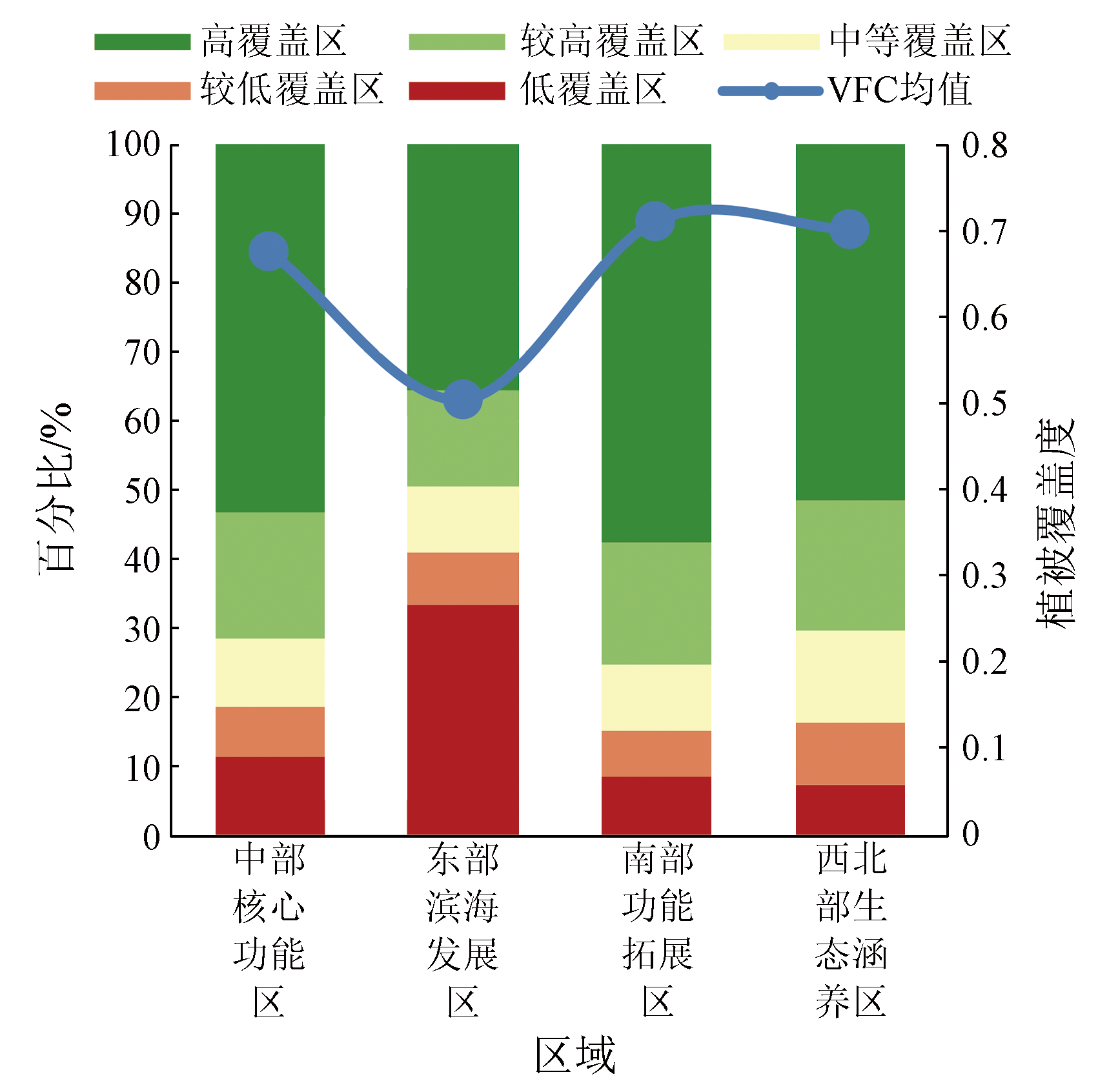
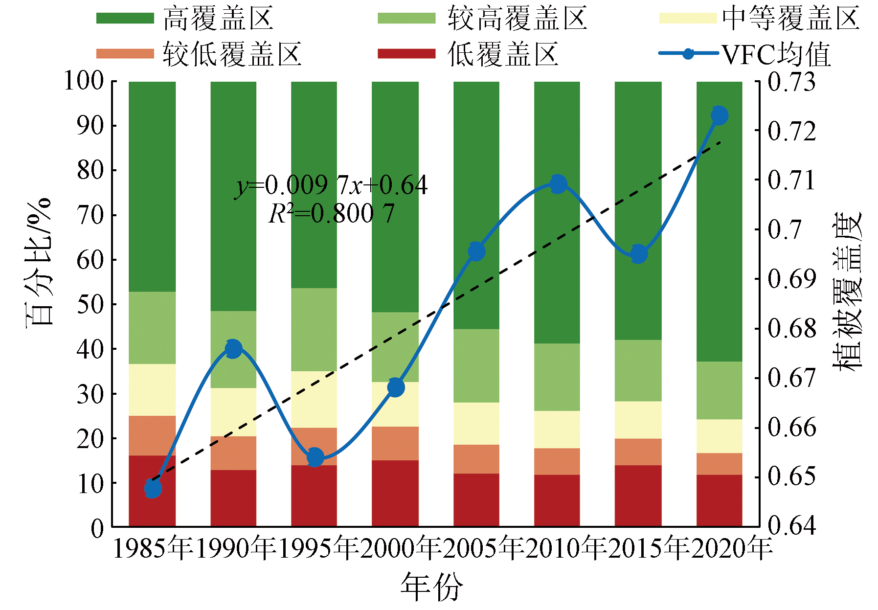
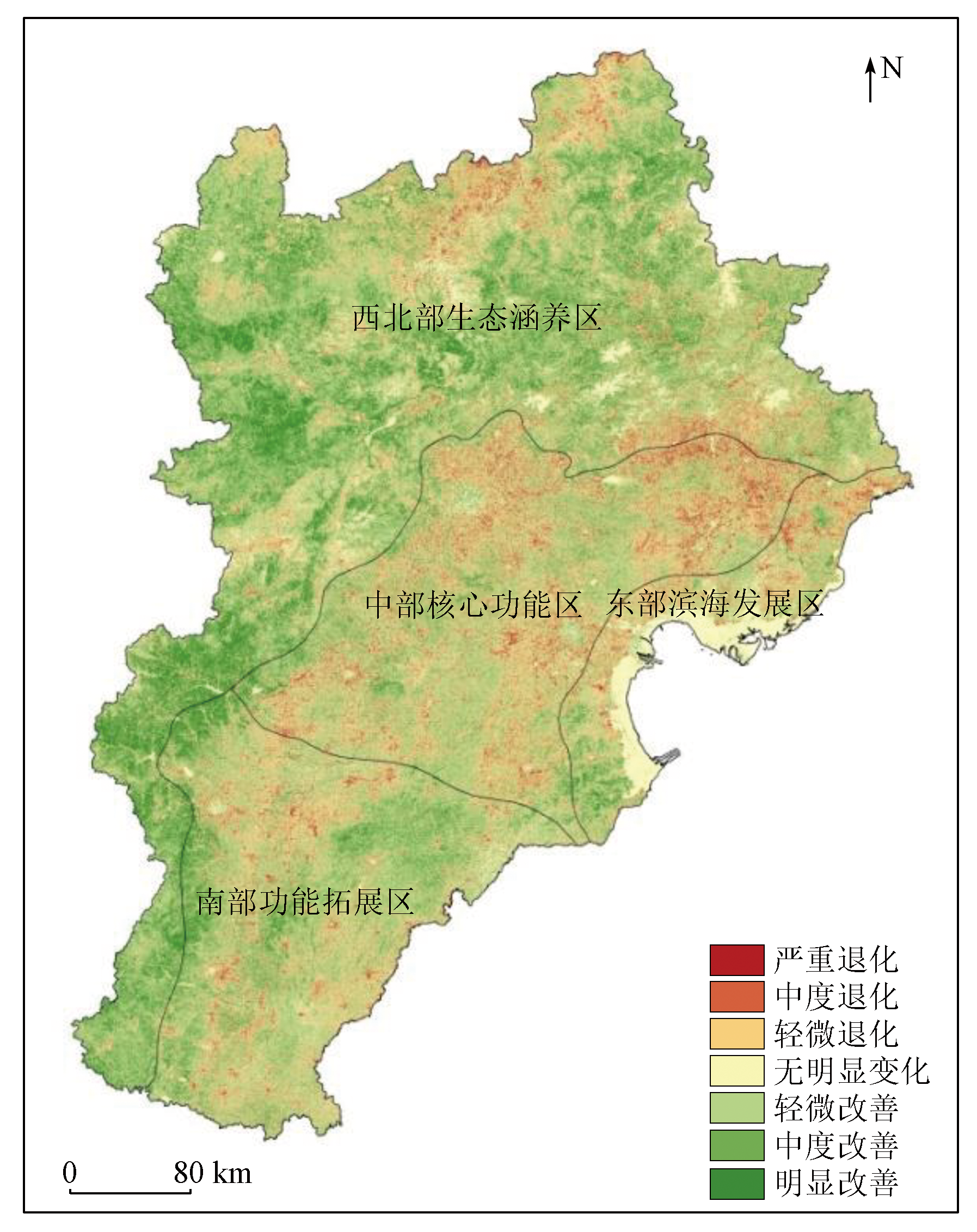
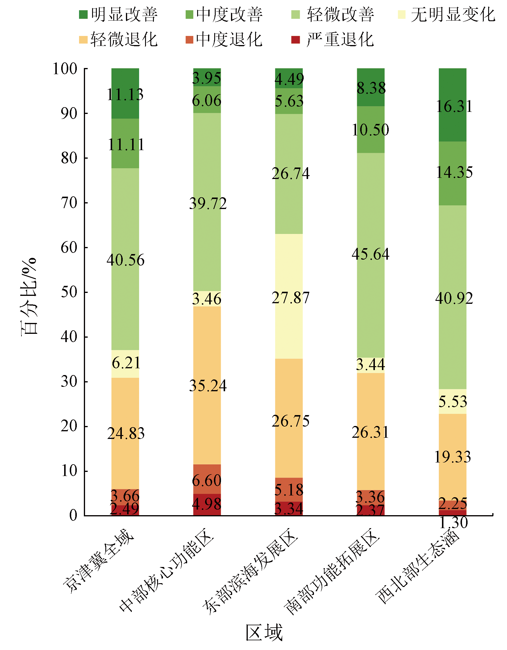
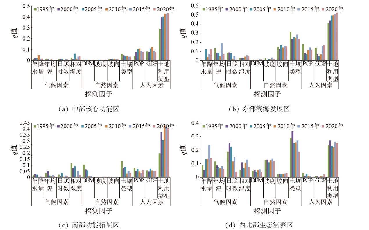
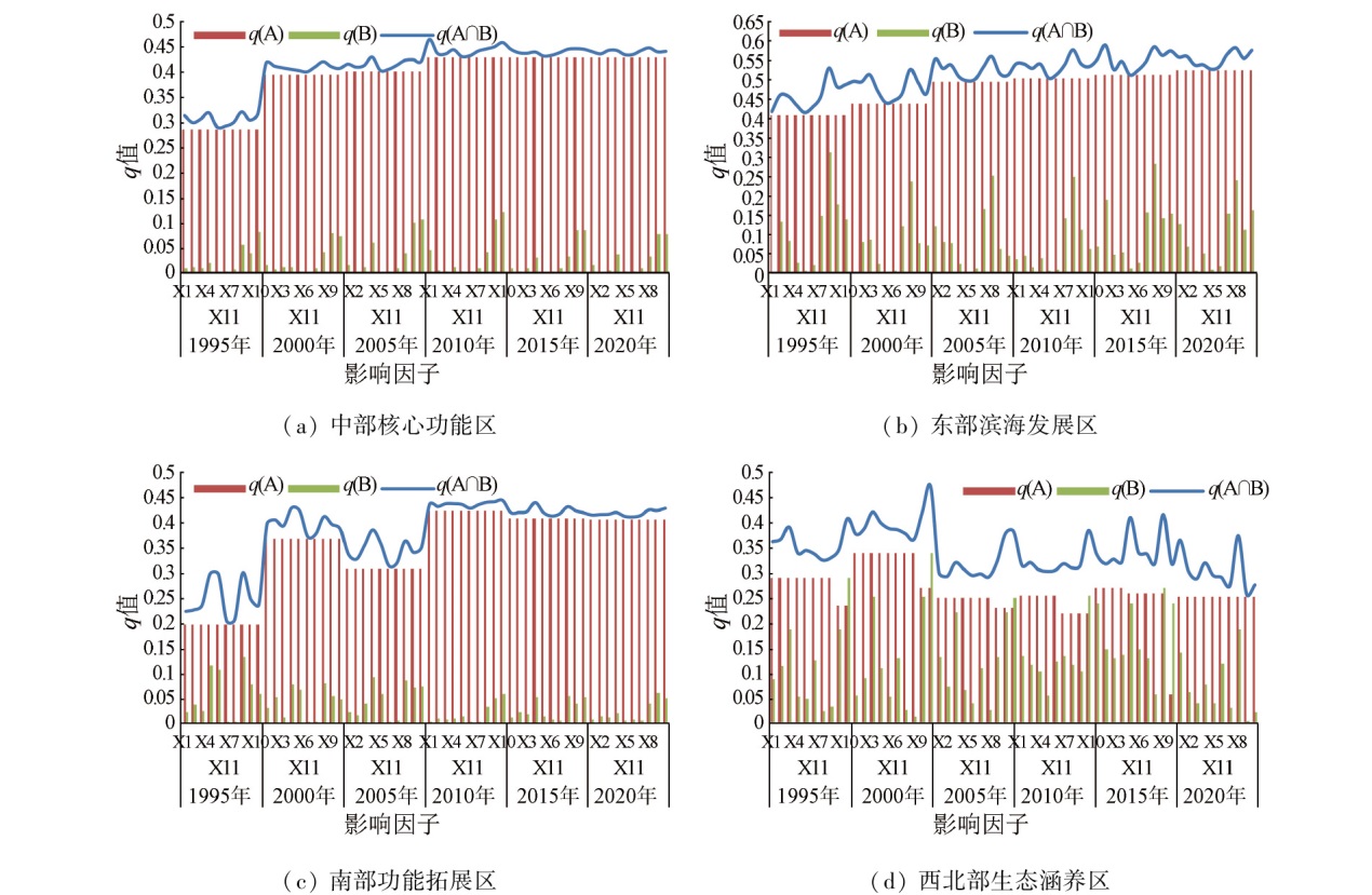
Abstract Based on 1985-2020 Landsat data, this study estimated eight phases of annual vegetation fractional cover (VFC) of the Beijing-Tianjin-Hebei region. Using the Theil-Sen Median and Mann-Kendall trend analyses, this study comprehensively analyzed the spatiotemporal variation characteristics of VFC in four major functional areas for the coordinated development of the Beijing-Tianjin-Hebei region. Furthermore, employing geodetectors, this study explored the degrees and mechanisms of the impacts of climatic, natural, and anthropogenic factors, along with their interactions, on the regional VFC from both static and dynamic perspectives. The results indicate that from 1985 to 2020, the Beijing-Tianjin-Hebei region exhibited sound vegetation coverage overall, which decreased in the order of the southern functional expansion area (SFEA), the northwestern ecological conservation area (NECA), the central core functional area (CCFA), the eastern coastal development area (ECDA). The VFC of the Beijing-Tianjin-Hebei region trended upward while fluctuating, with an increasing rate of 0.097%/10a. The VFC exhibited a spatial distribution pattern of high values in the west and low values in the east. Specifically, areas with elevated VFC were primarily distributed in the Yanshan, Damaqun, and Taihang mountains within the NECA, while those with reduced VFC were principally found in the built-up areas and their surrounding areas of cities and counties in the CCFA, ECDA, and SFEA. At the single-factor level, the primary and secondary factors controlling VFC across the four functional areas differed greatly, with land-use and soil types exhibiting higher interpretability. Regarding the influencing elements, the main factors driving spatial differentiation of VFC in the CCFA and SFEA included anthropogenic factors, those in ECDA comprised anthropogenic and natural factors, and those in NECA were dominated by climatic and natural factors. For the VFC of the four functional areas in all these years, the land use type manifested high interpretability, which trended upward overall. The q values of soil types were higher in ECDA and NECA, trending downward in the NECA. Secondary factors controlling the VFC exhibited different interannual interpretability in various functional areas. All influencing factors exhibited enhanced influence to varying extents, with no mutual independence or weakened influence observed. Additionally, the meteorological factor emerged as the primary interacting variable.
|
| Keywords
vegetation fractional cover
spatiotemporal variation
influencing factor
geodetector
functional regions
|
|
|
|
Issue Date: 23 December 2024
|
|
|
| [1] |
高涛. MODIS时间序列数据植被覆盖度反演方法研究[D]. 青岛: 山东科技大学, 2012.
|
| [1] |
Gao T. The method of vegetation fraction estimation by MODIS time series data[D]. Qingdao: Shandong University of Science and Technology, 2012.
|
| [2] |
李苗苗. 植被覆盖度的遥感估算方法研究[D]. 北京: 中国科学院遥感应用研究所, 2003.
|
| [2] |
Li M M. The method of vegetation fraction estimation by remote sensing[D]. Beijing: Institute of Remote Sensing Applications,Chinese Academy of Sciences, 2003.
|
| [3] |
冷若琳. 基于机器学习的祁连山草地植被覆盖度遥感估算研究[D]. 兰州: 兰州大学, 2020.
|
| [3] |
Leng R L. Remote sensing estimation of grassland fractional vegetation cover (FVC) based on machine learning method in Qilian Mountain[D]. Lanzhou: Lanzhou University, 2020.
|
| [4] |
张云霞, 李晓斌, 陈云浩. 草地植被盖度的多尺度遥感与实地测量方法综述[J]. 地球科学进展, 2003, 18(1):85-93.
doi: 10.11867/j.issn.1001-8166.2003.01.0085
|
| [4] |
Zhang Y X, Li X B, Chen Y H, et al. Overview of field and multi-scale remote sensing measurement approaches to grassland vegetation coverage[J]. Advance in Earth Sciences, 2003, 18(1):85-93.
|
| [5] |
丁艳玲. 植被覆盖度遥感估算及其真实性检验研究[D]. 北京: 中国科学院大学, 2015.
|
| [5] |
Ding Y L. Research on the estimation of fractional vegetation cover and the validation of fractional vegetation cover product[D]. Beijing: University of Chinese Academy of Sciences, 2015.
|
| [6] |
郭树茂. 基于3S技术的高寒草地植被覆盖度分布特征及动态变化研究[D], 兰州: 兰州大学, 2009.
|
| [6] |
Guo S M. Research of vegetation coverage distribution changes of alpine grassland based on 3S technology[D]. Lanzhou: Lanzhou University, 2009.
|
| [7] |
孟丹, 李小娟, 宫辉力, 等. 京津冀地区NDVI变化及气候因子驱动分析[J]. 地球信息科学, 2015, 8(17):1001-1007.
|
| [7] |
Meng D, Li X J, Gong H L, et al. Analysis of spatial-temporal change of NDVI and its climatic driving factors in Beijing-Tianjin-Hebei metropolis circle from 2001 to 2013[J]. Journal of Geo-information Science, 2015, 8(17):1001-1007.
|
| [8] |
马娜, 胡云锋, 庄大方, 等. 基于遥感和像元二分模型的内蒙古正蓝旗植被覆盖度格局和动态变化[J]. 地理科学, 2012, 32(2):251-256.
doi: 10.13249/j.cnki.sgs.2012.02.251
|
| [8] |
Ma N, HuY F, Zhuang D F, et al. Vegetation coverage distribution and its changes in plan blue banner based on remote sensing data and dimidiate pixel model[J]. Scientia Geographica Sinica, 2012, 32(2):251-256.
doi: 10.13249/j.cnki.sgs.2012.02.251
|
| [9] |
张喜旺, 吴炳方. 基于中高分辨率遥感的植被覆盖度时相变换方法[J]. 生态学报, 2015, 35(4):1155-1164.
|
| [9] |
Zhang X W, Wu B F. A temporal transformation method of fractional vegetation cover derived from high and moderate resolution remote sensing data[J]. Acta Ecologica Sinica, 2015, 5(4):1155-1164.
|
| [10] |
高永刚, 徐涵秋. 基于多源遥感影像的多尺度城市植被覆盖度估算[J]. 红外与毫米波学报, 2017, 36 (2):225-234.
|
| [10] |
Gao Y G, Xu H Q. Estimation of multi-scale urban vegetation coverage based on multi-source remote sensing images[J]. J Infrared Millim Waves, 2017, 36 (2):225-234.
|
| [11] |
吴青云, 高飞, 李振轩, 等. Sentinel-2A与Landsat8数据在植被覆盖度遥感估算中的比较[J]. 测绘通报, 2021(s1):104-108.
|
| [11] |
Wu Q Y, Gao F, Li Z X, et al. The contrast of Sentinel-2A and Landsat8 data in remote sensing estimation of vegetation coverage[J]. Bulletin of Surveying and Mapping. 2021(s1):104-108.
|
| [12] |
彭继达, 张春桂. 基于高分一号遥感影像的植被覆盖遥感监测——以厦门市为例[J]. 国土资源遥感, 2019, 31(4):137-142.doi:10.6046/gtzyyg.2019.04.18.
|
| [12] |
Peng J D, Zhang C G. Remote sensing monitoring of vegetation coverage by GF-1 satellite:A case study in Xiamen City[J]. Remote Sensing for land and Resources, 2019, 31(4):137-142.doi:10.6046/gtzyyg.2019.04.18.
|
| [13] |
李卓, 孙然好, 张继超, 等. 京津冀城市群地区植被覆盖动态变化时空分析[J]. 生态学报, 2017, 37(22):7418-7426.
|
| [13] |
Li Z, Sun R H, Zhang J C, et al. Temporal-spatial analysis of vegetation coverage dynamics in Beijing-Tianjin-Hebei metropolitan regions[J]. Acta Ecologica Sinica, 2017, 37(22):7418-7426.
|
| [14] |
孟琪, 武志涛, 杜自强, 等. 京津风沙源区不同分区植被覆盖度变化及归因分析[J]. 应用生态学报, 2021, 32(8):2895-2905.
doi: 10.13287/j.1001-9332.202108.018
|
| [14] |
Meng Q, Wu Z T, Du Z Q, et al. Variation in fractional vegetation cover and its attribution analysis of different regions of Beijing-Tianjin Sand Source Region,China[J]. Chinese Journal of Applied Ecology, 2021, 32(8):2895-2905.
|
| [15] |
晋成名, 杨兴旺, 景海涛. 基于RS的陕北地区植被覆盖度变化及驱动力研究[J]. 自然资源遥感, 2021, 33(4):258-264.doi:10.6046/zrzyyg.2021019.
|
| [15] |
Jin C M, Yang X W, Jing H T. A RS-based study on changes in fractional vegetation cover in North Shaanxi and their driving factors[J]. Remote Sensing for Natural Resources, 2021, 33(4):258-264.doi:10.6046/zrzyyg.2021019.
|
| [16] |
Park H S, Sohn B J. Recent trends in changes of vegetation over East Asia coupled with temperature and rainfall variations[J]. Journal of Geophysical Research Atmospheres, 2010, 115(D14) :D14101.
|
| [17] |
王小妹. 气候带复杂地理环境植被覆盖指数(NDVI)的时间变化特征及其与环境因子关系解析[D]. 兰州: 州交通大学, 2018.
|
| [17] |
Wang X M. The time variation characteristics of comple geographical vegetation cover index (NDVI) in multi-climate belt and its relationship with environmental factors[D]. Lanzhou: Lanzhou Jiaotong University, 2018.
|
| [18] |
蒋美琛. 基于遥感的京津冀植被变化监测与气候和非气候因素影响探究[D]. 北京: 中国地质大学(北京), 2020.
|
| [18] |
Jiang M C. Monitoring of vegetation change in Beijing-Tianjin-Hebei and exploration of the climatic and non-climatic influential factors based on remote sensing[D]. Beijing: China University of Geosciences(Beijing), 2020.
|
| [19] |
王冬梅, 孟兴民, 邢钊, 等. 基于RS的武都区植被覆盖度动态变化及其驱动力分析[J]. 干旱区资源与环境, 2012, 26(11):93-97.
|
| [19] |
Wang D M, Meng X M, Xing Z, et al. Dynamic change of vegetation coverage and the driving forces in Wudu district based on remote sensing[J]. Journal of Arid Land Resources and Environment, 2012, 26(11):93-97.
|
| [20] |
孟丹, 李小娟, 宫辉力, 等. 京津冀地区NDVI变化及气候因子驱动分析[J]. 地球信息科学学报, 2015, 12(35):1001-1006.
|
| [20] |
Meng D, Li X J, Gong H L, et al. Analysis of spatial-temporal change of NDVI and its climatic driving factors in Beijing-Tianjin-Hebei metropolis circle from 2001 to 2013[J]. Journal of Geo-information Science, 2015, 12(35):1001-1006.
|
| [21] |
陈奇乐, 谢梦姣, 李瑾璞, 等. 河北省植被NDVI变化及其对气象要素的响应[J]. 林业与生态科学, 2020, 35(1):17-24.
doi: 10.13320 / j.cnki.hjfor.2020.0003
|
| [21] |
Chen Q L, Xie M J, Li J P, et al. Change of vegetation NDVI and its response to meteorological elements in Hebei Province[J]. Forestry and Ecological Sciences, 2020, 35(1):17-24.
|
| [22] |
王劲峰, 徐成东. 地理探测器:原理与展望[J]. 地理学报, 2017, 72 (1):116-134.
doi: 10.11821/dlxb201701010
|
| [22] |
Wang J F, Xu C D. Geodetector:Principle and prospective[J]. Acta Geographica Sinica, 2017, 72 (1):116 -134.
|
| [23] |
孙雷刚, 徐全洪, 刘剑锋, 等. 一种年度区域植被覆盖度计算方法[Z]. 中国,CN107909607B. 2018-08-03.
|
| [23] |
Sun L G, Xu Q H, Liu J F, et al.A method for calculating annual regional vegetation coverage[Z],China,CN107909607B.2018-08-03.
|
| [24] |
岳胜如, 李瑞平, 徐冰. 内蒙古中部植被覆盖度监测及气象驱动力分析[J]. 湖北农业科学, 2015, 54(7):1574-1577.
|
| [24] |
Yue S R, Li R P, Xu B. The monitoring of vegetation coverage in middle inner mongolia and analyses of meteorological driving force[J]. Hubei Agricultural Sciences, 2015, 54(7):1574-1577.
|
| [25] |
祝聪, 彭文甫, 张丽芳, 等. 2006-2016 年岷江上游植被覆盖度时空变化及驱动力[J]. 生态学报, 2019, 39(5):1583-1594.
|
| [25] |
Zhu C, Peng W F, Zhang L F, et al. Study of temporal and spatial variation and driving force of fractional vegetation cover in upper reaches of Minjiang River from 2006 to 2016[J]. Acta Ecologica Sinica, 2019, 39(5):1583-1594.
|
| [26] |
裴志林, 杨勤科, 王春梅, 等. 黄河上游植被覆盖度空间分布特征及其影响因素[J]. 干旱区研究, 2019, 36(3):546-555.
|
| [26] |
Pei Z L, Yang Q K, Wang C M, et al. Spatial distribution of vegetation coverage and its affecting factors in the upper reaches of the Yellow River[J]. Arid Zone Research, 2019, 36(3):546-555.
|
| [27] |
Pouliot D, Latifovic R, Olthof L. Trends in vegetation NDVI from 1 km AVHRR data over Canada for the period 1985-2006[J]. International Journal of Remote Sensing, 2009, 30(1):149-168.
|
| [28] |
Yue S, Pilon P, Cavadias G. Power of the Mann-Kendall and spearman’s rho tests for detecting monotonic trends in hydrological series[J]. Journal of Hydrology, 2002, 259(1-4):254-271.
|
| [29] |
Kendall M G. Rank correlation methods (4th ed)[M]. London: Charles Griffin, 1970.
|
| [30] |
王伟, 阿里木·赛买提, 吉力力·阿不都外力. 基于地理探测器模型的中亚 NDVI 时空变化特征及其驱动因子分析[J]. 国土资源遥感, 2019, 31(4):32-40.doi:10.6046/gtzyyg.2019.04.05.
|
| [30] |
Wang W, Alim S, Jilili A. Geo-detector based spatio-temporal variation characteristics and driving factors analysis of NDVI in Central Asia[J]. Remote Sensing for Land and Resources, 2019, 31(4):32-40.doi:10.6046/gtzyyg.2019.04.05
|
| [31] |
王彦芳, 刘敏, 郭英. 1982—2015 年河北省生态环境支撑区植被覆盖动态及其可持续性[J]. 林业资源管理, 2018, 2(1):118-125.
|
| [31] |
Wang Y F, Liu M, Guo Y. Vegetation dynamics and sustainability in ecological supporting areas of Hebei[J]. Forest Resources Management, 2018, 2(1):118-125.
|
| [32] |
Eagleson P S. Ecohydrology:Darwinian expression of vegetation form and function[M]. Cambridge: Cambridge University Press, 2002.
|
| [33] |
陶帅, 邝婷婷, 彭文甫, 等. 2000—2015 年长江上游NDVI时空变化及驱动力分析——以宜宾市为例[J]. 生态学报, 2020, 40(14):5029-5043.
|
| [33] |
Tao S, Kuang T T, Peng W P, et al. Analyzing the spatio-temporal variation and drivers of NDVI in upper reaches of Yangtze River from 2000 to 2015:A case study of Yibin[J]. Acta Ecologica Sinica, 2020, 40(14):5029-5043.
|
| [34] |
王静, 周伟奇, 许开鹏, 等. 京津冀地区城市化对植被覆盖度及景观格局的影响[J]. 生态学报, 2017, 37(21):7019-7029.
|
| [34] |
Wang J, Zhou W Q, Xu K P, et al. Spatiotemporal pattern of vegetation cover and its relationship with urbanization in Beijing-Tianjin-Hebei megaregion from 2000 to 2010[J]. Acta Ecologica Sinica, 2017, 37(21):7019-7029.
|
|
Viewed |
|
|
|
Full text
|
|
|
|
|
Abstract
|
|
|
|
|
Cited |
|
|
|
|
| |
Shared |
|
|
|
|
| |
Discussed |
|
|
|
|
 2024,
Vol. 36
2024,
Vol. 36