|
|
 |
|

|
|
|
Application of high-resolution InSAR technique in monitoring deformations in the Beijing Daxing International Airport |
ZHAO Xia1,2( ), MA Xinyan1,2(), YU Qian1,2, WANG Zhaobing1,2 ), MA Xinyan1,2(), YU Qian1,2, WANG Zhaobing1,2 |
1. China Airport Planning & Design Institute Co., Ltd., Beijing 100029, China
2. Observation and Research Base of Transport Industray of Airport Engineering Safety and Long-term Performance, Beijing 100029, China |
|
|
|
|
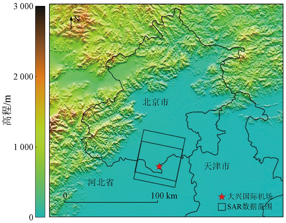
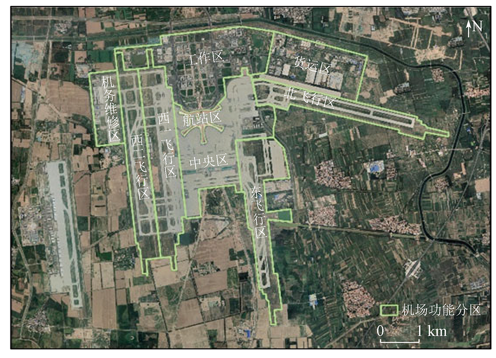
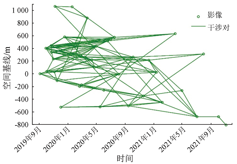
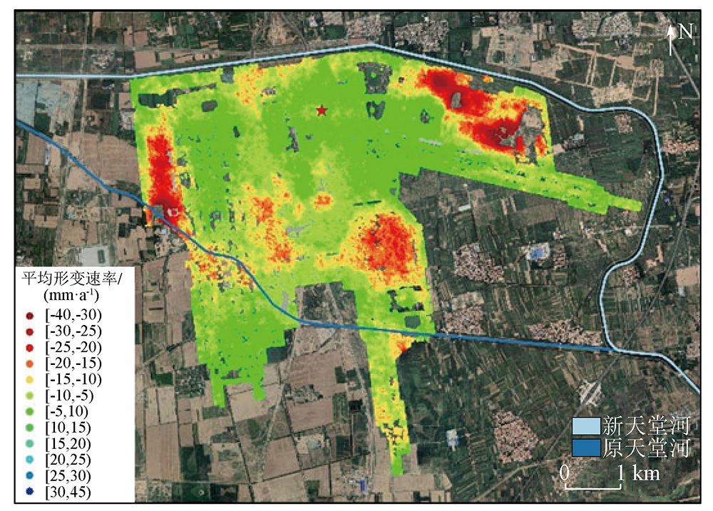
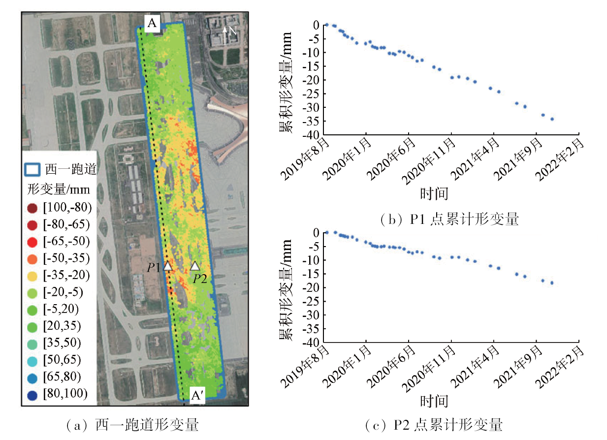
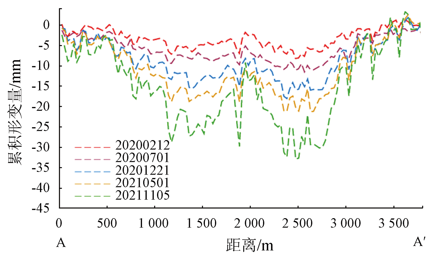
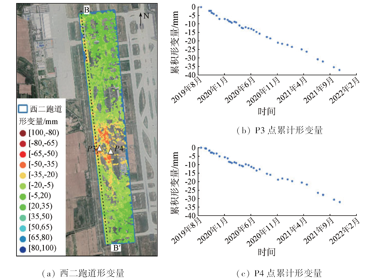
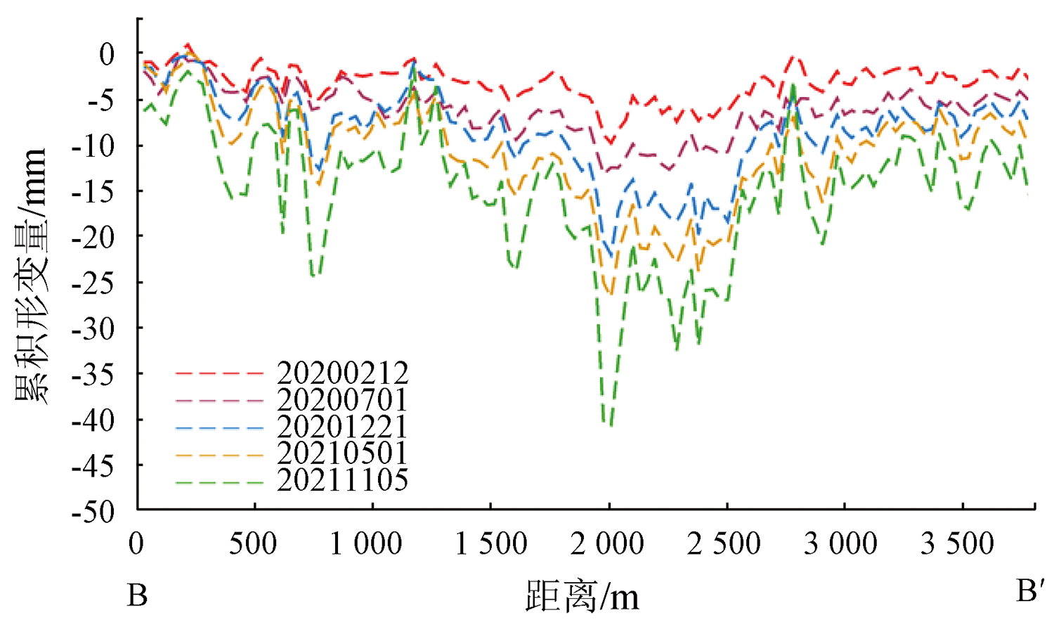
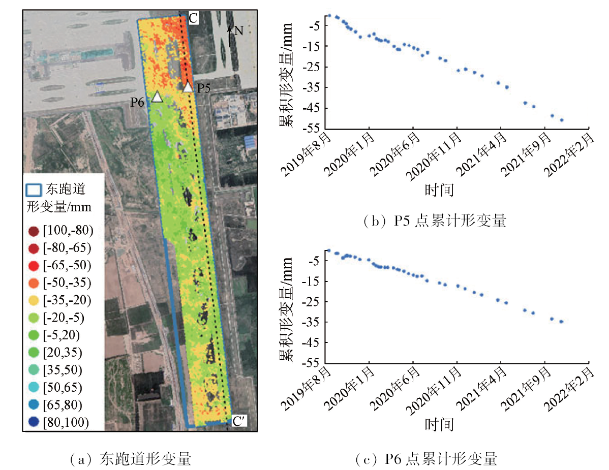
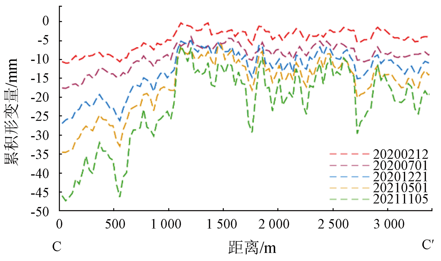
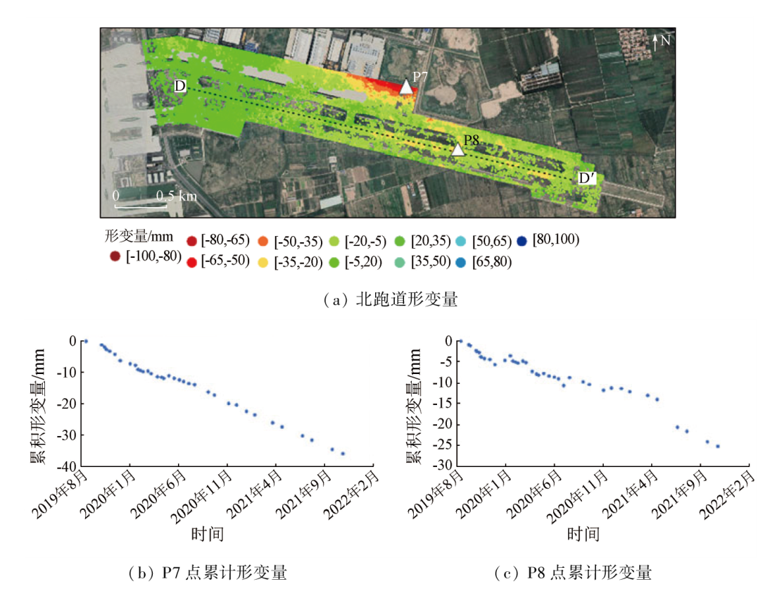
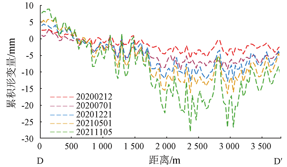
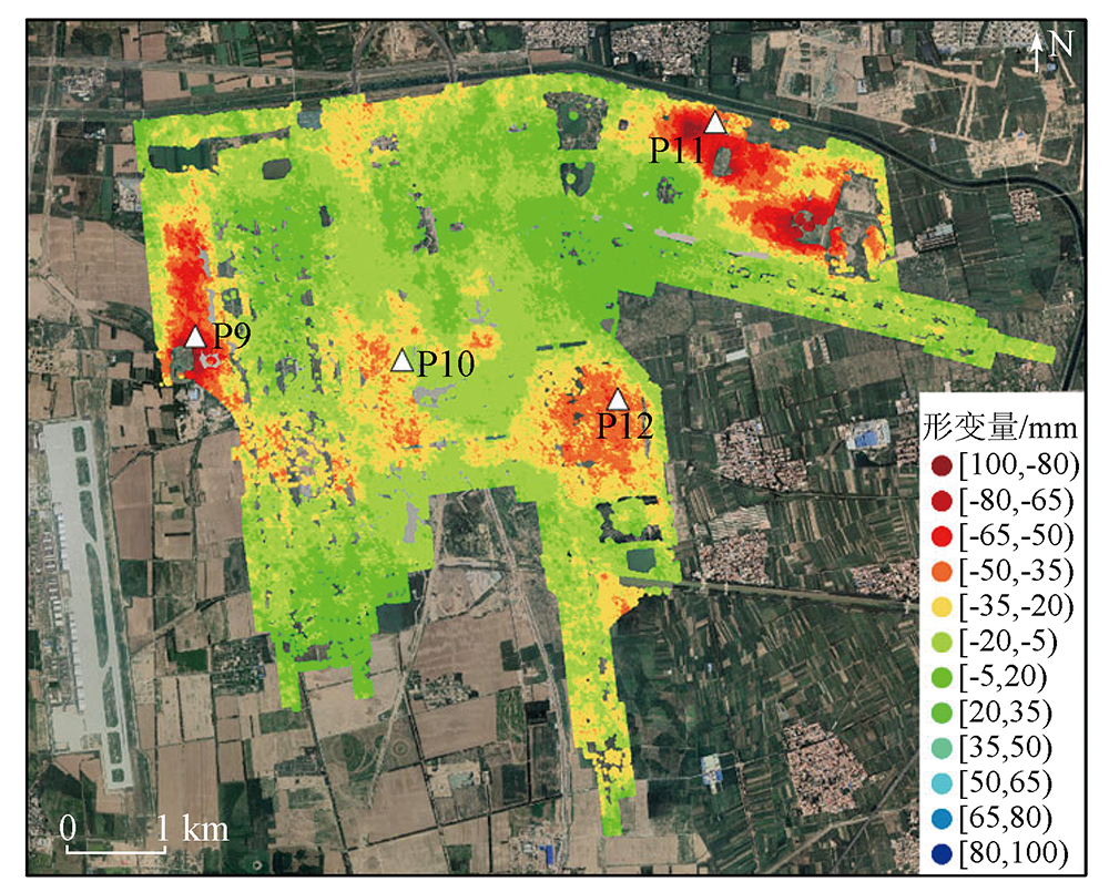
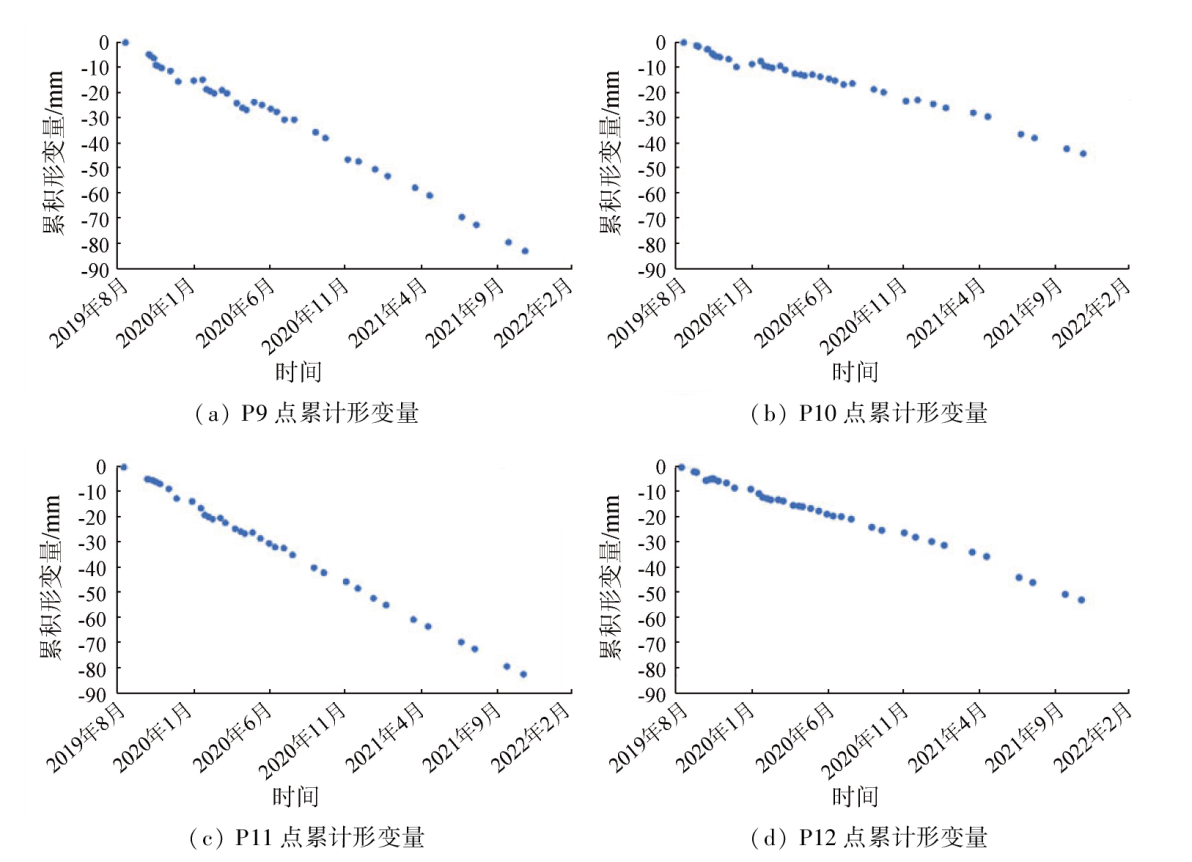
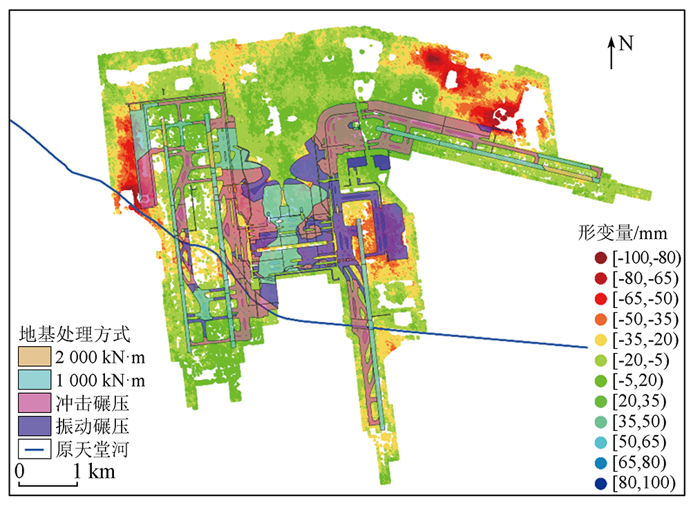
Abstract The Beijing Daxing International Airport, located in the Yufa—Lixian area of Daxing District, is one of Beijing’s five major land subsidence areas. Differential deformations pose risks to the airport’s safe and stable operation. By applying the time-series interferometric synthetic aperture Radar (InSAR) technique, this study obtained the spatio-temporal characteristics of the airport’s deformations from 39 scenes of high-resolution COSMO-SkyMed (CSK) SAR images taken from September 2019 to November 2021. The monitoring results, with high accuracy, are roughly consistent with level monitoring results. Findings indicate that the airport’s subsidence lasted from 2019 to 2021, with the highest subsidence rate measured at -47.5 mm/a and a maximum cumulative subsidence amount of -103.84 mm. Notably, all four runways exhibited varying degrees of differential subsidence. Furthermore, this study delved into the spatio-temporal characteristics of deformations in the runways, as well as deformations in other high-deformation zones such as terminal buildings, maintenance aprons, oil tank areas, and the business jet apron. By combining the foundation treatment, this study analyzed the factors influencing the airport’s subsidence, providing a reference for the airport’s safe and stable operation.
|
| Keywords
time-series InSAR
deformation monitoring
Beijing Daxing International Airport
COSMO-SkyMed
influencing factor
|
|
|
|
Issue Date: 13 March 2024
|
|
|
| [1] |
Xu Y S, Shen S L, Cai Z Y, et al. The state of land subsidence and prediction approaches due to groundwater withdrawal in China[J]. Natural Hazards, 2008, 45(1):123-135.
doi: 10.1007/s11069-007-9168-4
url: http://link.springer.com/10.1007/s11069-007-9168-4
|
| [2] |
郭萌, 陈刚, 黄骁, 等. 北京大兴规划新城地面沉降研究[J]. 城市地质, 2011, 6(1):17-21.
|
| [2] |
Guo M, Chen G, Huang X, et al. Study on the surface subsidence in Beijing metro planning Daxing[J]. Urban Geology, 2011, 6(1):17-21.
|
| [3] |
罗勇, 贾三满, 赵波, 等. 北京南部地区地面沉降发育特征及成因分析[J]. 城市地质, 2011, 6(3):1-5,21.
|
| [3] |
Luo Y, Jia S M, Zhao B, et al. Characteristics and causes of land subsidence in the south of Beijing[J]. Urban Geology, 2011, 6(3):1-5,21.
|
| [4] |
Jiang L, Lin H. Integrated analysis of SAR interferometric and geological data for investigating long-term reclamation settlement of Chek Lap Kok Airport,Hong Kong[J]. Engineering Geology, 2010, 110(3/4):77-92.
doi: 10.1016/j.enggeo.2009.11.005
url: https://linkinghub.elsevier.com/retrieve/pii/S0013795209002956
|
| [5] |
Dong J, Zhang L, Li M, et al. Measuring precursory movements of the recent Xinmo landslide in Mao County,China with Sentinel-1 and ALOS-2 PALSAR-2 datasets[J]. Landslides, 2018, 15(1):135-144.
doi: 10.1007/s10346-017-0914-8
url: http://link.springer.com/10.1007/s10346-017-0914-8
|
| [6] |
Jiang Y, Liao M, Wang H, et al. Deformation monitoring and analysis of the geological environment of Pudong international airport with persistent scatterer SAR interferometry[J]. Remote Sensing, 2016, 8(12):1021.
doi: 10.3390/rs8121021
url: http://www.mdpi.com/2072-4292/8/12/1021
|
| [7] |
麻源源, 左小清, 麻卫峰, 等. 基于SBAS-InSAR技术对昆明机场高边坡沉降监测研究[J]. 工程勘察, 2018, 46(7):22-27,39.
|
| [7] |
Ma Y Y, Zuo X Q, Ma W F, et al. Kunming airport high slope settlement monitoring based on SBAS-InSAR[J]. Geotechnical Investigation & Surveying, 2018, 46(7):22-27,39.
|
| [8] |
Dai K, Shi X, Gou J, et al. Diagnosing subsidence geohazard at Beijing capital international airport,from high-resolution SAR interferometry[J]. Sustainability, 2020, 12(6):2269.
doi: 10.3390/su12062269
url: https://www.mdpi.com/2071-1050/12/6/2269
|
| [9] |
张双成, 司锦钊, 徐永福, 等. 时序InSAR用于安康膨胀土机场稳定性监测[J]. 武汉大学学报(信息科学版), 2021, 46(10):1519-1528.
|
| [9] |
Zhang S C, Si J Z, Xu Y F, et al. Time-series InSAR for stability monitoring of Ankang Airport with expansive soil[J]. Geomatics and Information Science of Wuhan University, 2021, 46(10):1519-1528.
|
| [10] |
Shi X, Chen C, Dai K, et al. Monitoring and predicting the subsidence of Dalian Jinzhou Bay International Airport,China by integrating InSAR observation and Terzaghi consolidation theory[J]. Remote Sensing, 2022, 14(10):2332.
doi: 10.3390/rs14102332
url: https://www.mdpi.com/2072-4292/14/10/2332
|
| [11] |
丛易敏行. 机场场道变形监测及预警研究[D]. 北京: 北京航空航天大学, 2020.
|
| [11] |
Cong Y M X. Research on monitoring and prediction of deformation on airport runway[D]. Beijing: Beihang University, 2020.
|
| [12] |
赵建华, 张晓峰, 王路兵, 等. 北京大兴国际机场绿色运营实践与展望[J]. 环境保护, 2021, 49(11):18-21.
|
| [12] |
Zhao J H, Zhang X F, Wang L B, et al. Practice and prospect of green operation of Beijing Daxing International Airport[J]. Environmental Protection, 2021, 49(11):18-21.
|
| [13] |
Caltagirone F, Angino G, Coletta A, et al. COSMO-SkyMed program:Status and perspectives[M].Pisa,Italy: 2003:24-26.
|
| [14] |
Battazza F, Coletta A, Lopinto E, et al. COSMO-SkyMed an existing opportunity for observing the Earth[J]. Journal of Geodynamics, 2010, 49(3/4):171-180.
doi: 10.1016/j.jog.2010.01.001
url: https://linkinghub.elsevier.com/retrieve/pii/S0264370710000050
|
| [15] |
Hu L, Dai K, Xing C, et al. Land subsidence in Beijing and its relationship with geological faults revealed by Sentinel-1 InSAR observations[J]. International Journal of Applied Earth Observation and Geoinformation, 2019, 82:101886.
doi: 10.1016/j.jag.2019.05.019
url: https://linkinghub.elsevier.com/retrieve/pii/S0303243418308821
|
| [16] |
Fattahi H. Geodetic imaging of tectonic deformation with InSAR[D]. Miami: University of Miami, 2015.
|
| [17] |
Gagliardi V, Bianchini Ciampoli L, Trevisani S, et al. Testing sentinel-1 SAR interferometry data for airport runway monitoring:A geostatistical analysis[J]. Sensors, 2021, 21(17):5769.
doi: 10.3390/s21175769
url: https://www.mdpi.com/1424-8220/21/17/5769
|
| [18] |
Liu G, Ding X, Chen Y, et al. Ground settlement of Chek Lap Kok Airport,Hong Kong,detected by satellite synthetic aperture Radar interferometry[J]. Chinese Science Bulletin, 2001, 46(21):1778-1782.
doi: 10.1007/BF02900548
url: http://link.springer.com/10.1007/BF02900548
|
| [19] |
Puzrin A M, Alonso E E, Pinyol N M. Unexpected excessive settlements:Kansai international airport,Japan[M]//Geomechanics of Failures. Dordrecht:Springer, 2010:23-43.
|
| [20] |
White G. State of the art:Asphalt for airport pavement surfacing[J]. International Journal of Pavement Research and Technology, 2018, 11(1):77-98.
doi: 10.1016/j.ijprt.2017.07.008
url: https://linkinghub.elsevier.com/retrieve/pii/S1996681417300068
|
| [21] |
梁永辉, 王卫东, 冯世进, 等. 高填方机场湿陷性粉土地基处理现场试验研究[J]. 岩土工程学报, 2022, 44(6):1027-1035.
|
| [21] |
Liang Y H, Wang W D, Feng S J, et al. Field study on treatment of collapsible silt for high-fill airport project[J]. Chinese Journal of Geotechnical Engineering, 2022, 44(6):1027-1035.
|
|
Viewed |
|
|
|
Full text
|
|
|
|
|
Abstract
|
|
|
|
|
Cited |
|
|
|
|
| |
Shared |
|
|
|
|
| |
Discussed |
|
|
|
|
 2024,
Vol. 36
2024,
Vol. 36