|
|
 |
|

|
|
|
Remote sensing-based bathymetry retrieval of supraglacial lakes on polar ice sheets using images from small optical satellite PlanetScope and ICESat-2 laser altimetry data |
ZHU Yuxin1,2,3( ), MAN Mengtian1,2,3, WANG Yuhan1,2,3, CHEN Dinghua1,2,3, YANG Kang1,2,3() ), MAN Mengtian1,2,3, WANG Yuhan1,2,3, CHEN Dinghua1,2,3, YANG Kang1,2,3() |
1. School of Geography and Ocean Science, Nanjing University, Nanjing 210023, China
2. Jiangsu Provincial Key Laboratory of Geographic Information Science and Technology, Nanjing 210023, China
3. Collaborative Innovation Center of South China Sea Studies, Nanjing 210023, China |
|
|
|
|
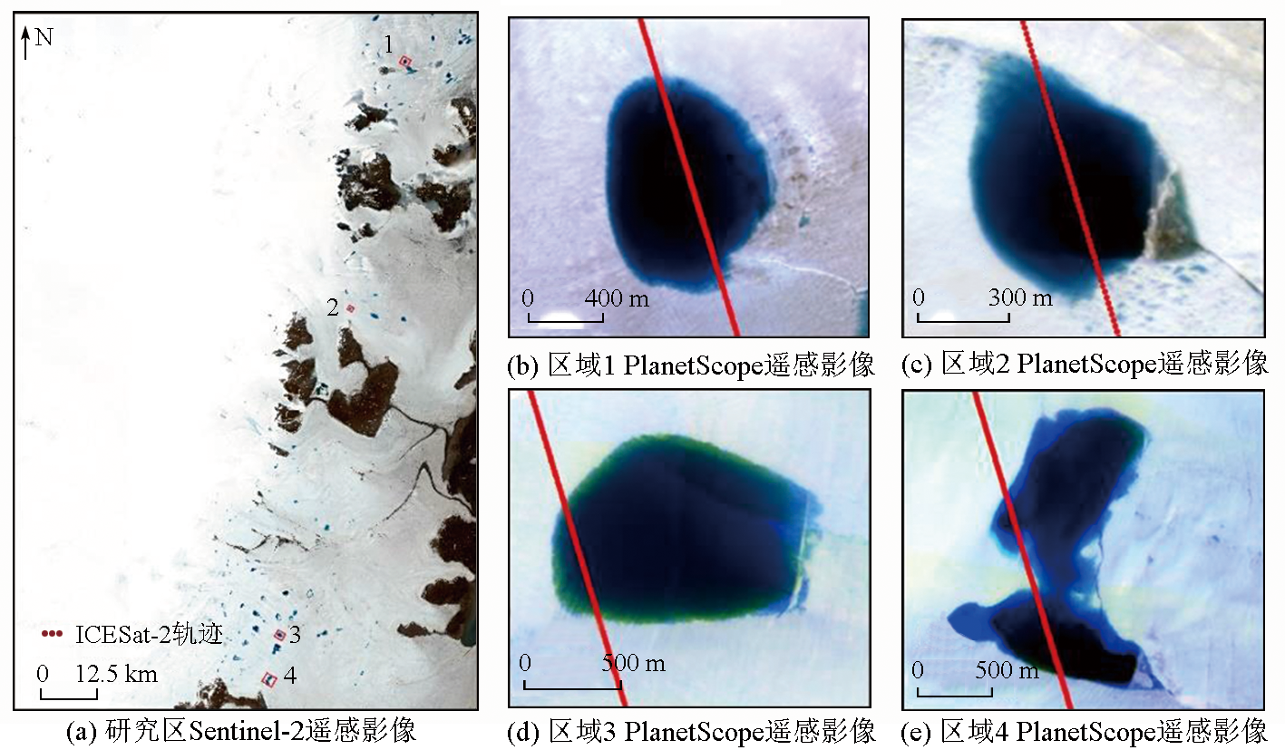
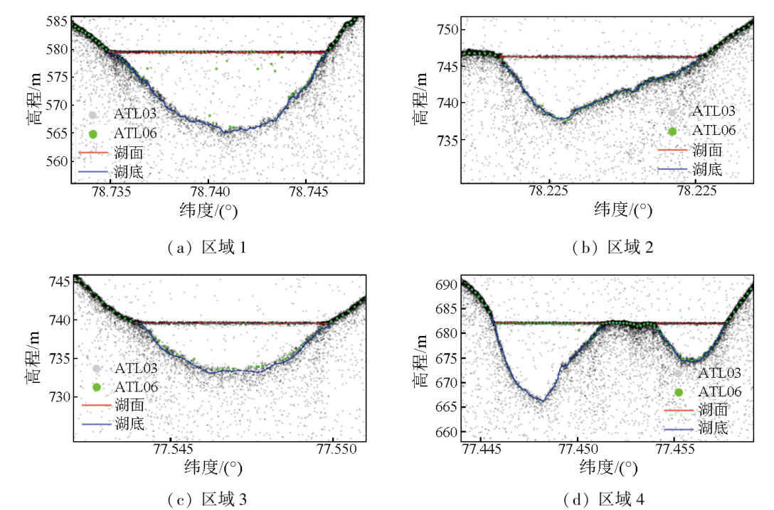
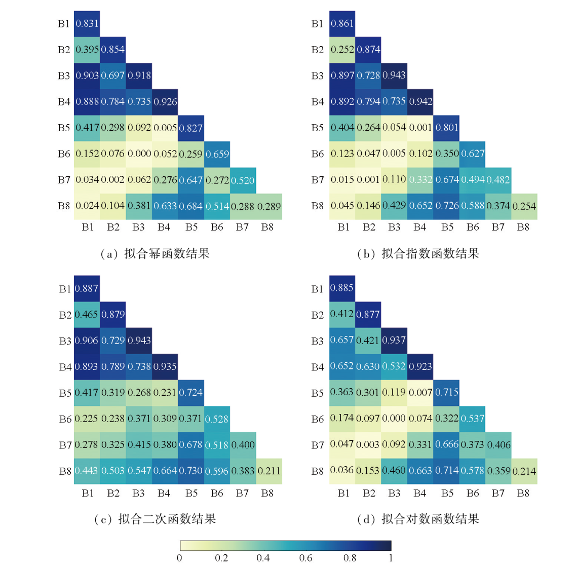
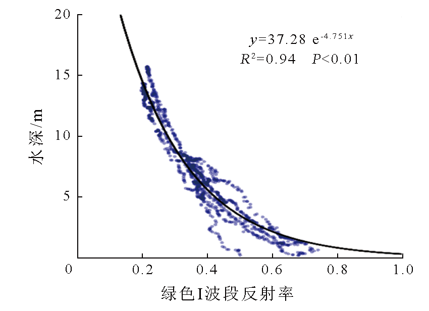
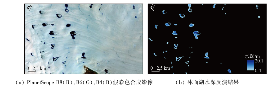
Abstract During the melt season, supraglacial lakes are widely distributed across polar ice sheets, storing large amounts of surface meltwater. When some of these supraglacial lakes rupture at the bottom, the released meltwater infiltrates ice sheets, affecting their movement and stability. Therefore, accurate bathymetry retrieval of supraglacial lakes and estimating the volume of supraglacial lakes are significant for understanding the hydrological processes of polar ice sheets. However, field measurement of supraglacial lake depth is difficult, costly, and small-scale. Meanwhile, the bathymetry models derived from optical satellite images with low to medium spatial resolutions are insufficiently accurate. Given these, this study conducted the bathymetry retrieval of supraglacial lakes based on eight-band remote sensing images from the small-size optical satellite PlanetScope SuperDove (spatial resolution: 3 m) and ICESat-2 laser altimetry data. First, the ICESat-2 laser altimetry point clouds data for the lake surface and bottom were separated and modeled using adaptive kernel density estimation to derive lake depth observations. Second, Optimal Band Ratio Analysis (OBRA) was used to examine the correlations between various bands of PlanetScope images (and combinations thereof) and ICESat-2 bathymetry data, leading to the development of four kinds of empirical formulas for the bathymetry retrieval of supraglacial lakes: quadratic, exponential, power, and logarithmic functions. Then, four supraglacial lakes covered by concurrent PlanetScope and ICESat-2 data were selected to test the retrieval accuracy. The results indicate that the Green I band of PlanetScope is the most favorable for the bathymetry retrieval, demonstrating the strongest correlation with the ICESat-2 derived depths (R2=0.94) and the highest inversion accuracy (RMSE=1.0 m, RRMSE=0.15). The study reveals that integrating active and passive satellite data has great potential for analyzing hydrological processes in polar ice sheets.
|
| Keywords
supraglacial lake
PlanetScope
ICESat-2
bathymetry
|
|
|
|
Issue Date: 23 December 2024
|
|
|
| [1] |
Bamber J L, Westaway R M, Marzeion B, et al. The land ice contribution to sea level during the satellite era[J]. Environmental Research Letters, 2018, 13(6):063008.
|
| [2] |
杨康. 格陵兰冰盖表面消融研究进展[J]. 冰川冻土, 2013, 35(1):101-109.
doi: 10.7522/j.issn.1000-0240.2013.0012
|
| [2] |
Yang K. The progress of Greenland Ice Sheet surface ablation research[J]. Journal of Glaciology and Geocryology, 2013, 35(1):101-109.
doi: 10.7522/j.issn.1000-0240.2013.0012
|
| [3] |
McMillan M, Nienow P, Shepherd A, et al. Seasonal evolution of supra-glacial lakes on the Greenland Ice Sheet[J]. Earth and Planetary Science Letters, 2007, 262(3/4):484-492.
|
| [4] |
杨康, 刘巧. 冰川表面水文过程研究进展[J]. 冰川冻土, 2016, 38(6):1666-1678.
doi: 10.7522/j.issn.1000-0240.2016.0194
|
| [4] |
Yang K, Liu Q. Supraglacial drainage system:A review[J]. Journal of Glaciology and Geocryology, 2016, 38(6):1666-1678.
|
| [5] |
Stevens L A, Behn M D, McGuire J J, et al. Greenland supraglacial lake drainages triggered by hydrologically induced basal slip[J]. Nature, 2015, 522(7554):73-76.
|
| [6] |
Tuckett P A, Ely J C, Sole A J, et al. Rapid accelerations of An-tarctic Peninsula outlet glaciers driven by surface melt[J]. Nature Communications, 2019, 10:4311.
doi: 10.1038/s41467-019-12039-2
pmid: 31541114
|
| [7] |
Box J E, Ski K. Remote sounding of Greenland supraglacial melt lakes:Implications for subglacial hydraulics[J]. Journal of Glaci-ology, 2007, 53(181):257-265.
|
| [8] |
Tedesco M, Steiner N. In-situ multispectral and bathymetric measurements over a supraglacial lake in western Greenland using a remotely controlled watercraft[J]. The Cryosphere, 2011, 5(2):445-452.
|
| [9] |
Legleiter C J, Tedesco M, Smith L C, et al. Mapping the bathymetry of supraglacial lakes and streams on the Greenland ice sheet using field measurements and high-resolution satellite images[J]. The Cryosphere, 2014, 8(1):215-228.
|
| [10] |
Fitzpatrick A A W, Hubbard A L, Box J E, et al. A decade (2002—2012) of supraglacial lake volume estimates across Russell Glacier,West Greenland[J]. The Cryosphere, 2014, 8(1):107-121.
|
| [11] |
Pope A, Scambos T A, Moussavi M, et al. Estimating supraglacial lake depth in West Greenland using Landsat 8 and comparison with other multispectral methods[J]. The Cryosphere, 2016, 10(1):15-27.
|
| [12] |
Moussavi M S, Abdalati W, Pope A, et al. Derivation and validation of supraglacial lake volumes on the Greenland Ice Sheet from high-resolution satellite imagery[J]. Remote Sensing of Environment, 2016, 183:294-303.
|
| [13] |
Hsu H J, Huang C Y, Jasinski M, et al. A semi-empirical scheme for bathymetric mapping in shallow water by ICESat-2 and Sentinel-2:A case study in the South China Sea[J]. ISPRS Journal of Photogrammetry and Remote Sensing, 2021, 178:1-19.
|
| [14] |
Albright A, Glennie C. Nearshore bathymetry from fusion of Sentinel-2 and ICESat-2 observations[J]. IEEE Geoscience and Remote Sensing Letters, 2021, 18(5):900-904.
doi: 10.1109/LGRS.2020.2987778
|
| [15] |
Xu N, Ma X, Ma Y, et al. Deriving highly accurate shallow water bathymetry from Sentinel-2 and ICESat-2 datasets by a multitemporal stacking method[J]. IEEE Journal of Selected Topics in Applied Earth Observations and Remote Sensing, 2021, 14:6677-6685.
|
| [16] |
Fair Z, Flanner M, Brunt K M, et al. Using ICESat-2 and Operation IceBridge altimetry for supraglacial lake depth retrievals[J]. The Cryosphere, 2020, 14(11):4253-4263.
|
| [17] |
Fricker H A, Arndt P, Brunt K M, et al. ICESat-2 meltwater depth estimates:Application to surface melt on Amery Ice Shelf,East Antarctica[J]. Geophysical Research Letters, 2021, 48(8):e2020GL090550.
|
| [18] |
Qayyum N, Ghuffar S, Ahmad H, et al. Glacial lakes mapping using multi satellite PlanetScope imagery and deep learning[J]. ISPRS International Journal of Geo-Information, 2020, 9(10):560.
|
| [19] |
Datta R T, Wouters B. Supraglacial lake bathymetry automatically derived from ICESat-2 constraining lake depth estimates from multi-source satellite imagery[J]. The Cryosphere, 2021, 15(11):5115-5132.
|
| [20] |
Roy D P, Huang H, Houborg R, et al. A global analysis of the temporal availability of PlanetScope high spatial resolution multi-spectral imagery[J]. Remote Sensing of Environment, 2021, 264:112586.
|
| [21] |
Bamber J L, Layberry R L, Gogineni S P. A new ice thickness and bed data set for the Greenland ice sheet:1.Measurement,data reduction,and errors[J]. Journal of Geophysical Research:Atmospheres, 2001, 106(D24):33773-33780.
|
| [22] |
Noël B, van de Berg W J, Lhermitte S, et al. Rapid ablation zone expansion amplifies North Greenland mass loss[J]. Science Advances, 2019, 5(9):eaaw0123.
|
| [23] |
Abdalati W, Zwally H J, Bindschadler R, et al. The ICESat-2 laser altimetry mission[J]. Proceedings of the IEEE, 2010, 98(5):735-751.
|
| [24] |
Babbel B J, Parrish C E, Magruder L A. ICESat-2 elevation retrievals in support of satellite-derived bathymetry for global science applications[J]. Geophysical Research Letters, 2021, 48(5):e2020GL090629.
|
| [25] |
Ranndal H, Sigaard Christiansen P, Kliving P, et al. Evaluation of a statistical approach for extracting shallow water bathymetry signals from ICESat-2 ATL03 photon data[J]. Remote Sensing, 2021, 13(17):3548.
|
| [26] |
Parrish C E, Magruder L A, Neuenschwander A L, et al. Validation of ICESat-2 ATLAS bathymetry and analysis of ATLAS’s bathymetric mapping performance[J]. Remote Sensing, 2019, 11(14):1634.
|
| [27] |
Cao B, Fang Y, Gao L, et al. An active-passive fusion strategy and accuracy evaluation for shallow water bathymetry based on ICESat-2 ATLAS laser point cloud and satellite remote sensing imagery[J]. International Journal of Remote Sensing, 2021, 42(8):2783-2806.
|
| [28] |
Li Y, Gao H, Zhao G, et al. A high-resolution bathymetry dataset for global reservoirs using multi-source satellite imagery and alti-metry[J]. Remote Sensing of Environment, 2020, 244:111831.
|
| [29] |
Neumann T A, Martino A J, Markus T, et al. The Ice,Cloud,and Land Elevation Satellite - 2 mission:A global geolocated photon product derived from the Advanced Topographic Laser Altimeter System[J]. Remote Sensing of Environment, 2019, 233:111325.
|
| [30] |
Yuan C, Gong P, Bai Y. Performance assessment of ICESat-2 laser altimeter data for water-level measurement over lakes and reservoirs in China[J]. Remote Sensing, 2020, 12(5):770.
|
| [31] |
Smith B, Fricker H A, Holschuh N, et al. Land ice height-retrieval algorithm for NASA’s ICESat-2 photon-counting laser altimeter[J]. Remote Sensing of Environment, 2019, 233:111352.
|
|
Viewed |
|
|
|
Full text
|
|
|
|
|
Abstract
|
|
|
|
|
Cited |
|
|
|
|
| |
Shared |
|
|
|
|
| |
Discussed |
|
|
|
|
 2024,
Vol. 36
2024,
Vol. 36