|
|
 |
|

|
|
|
Forest stock volume inversion based on ICESat-2 and Sentinel-2A data |
LIU Meiyan1,2( ), NIE Sheng2(), WANG Cheng2, XI Xiaohuan2, CHENG Feng1, FENG Baokun1 ), NIE Sheng2(), WANG Cheng2, XI Xiaohuan2, CHENG Feng1, FENG Baokun1 |
1. Faculty of Geography, Yunnan Normal University, Kunming 650500, China
2. Key Laboratory of Digital Earth Sciences, Aerospace Information Research Institute, Chinese Academy of Sciences, Beijing 100094, China |
|
|
|
|
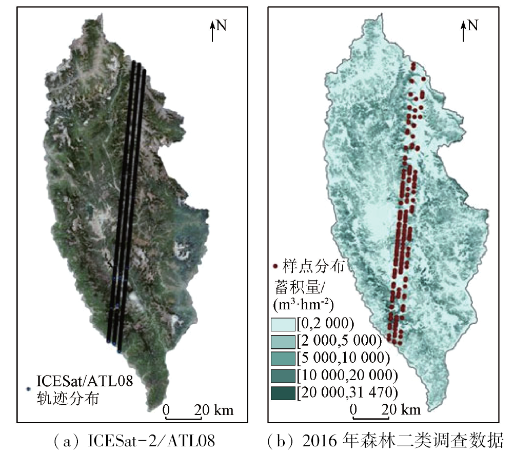
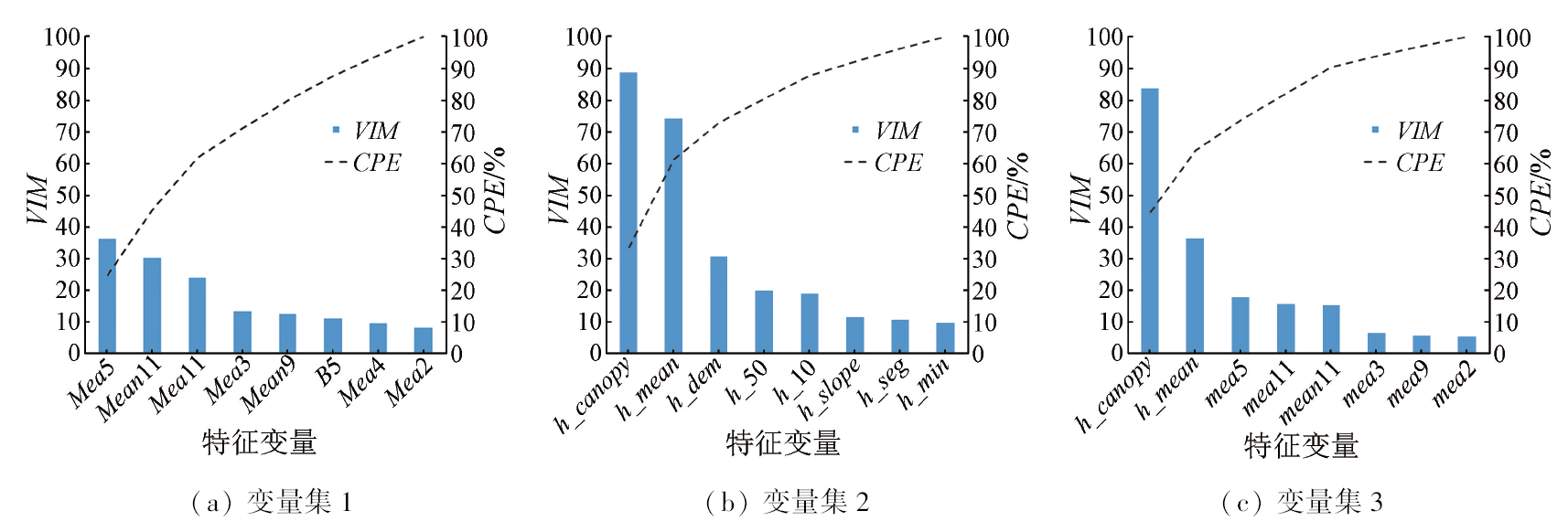
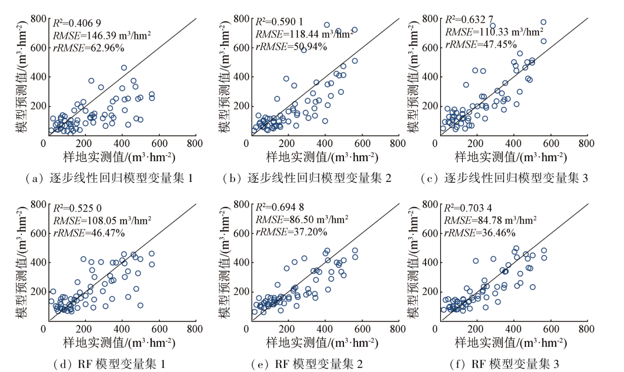
Abstract Forest stock volume (FSV), a critical indicator in forestry surveys, plays a significant role in evaluating the health and carbon sequestration capacity of forests. Cooperative inversion using active and passive remote sensing data is an essential method for FSV inversion of large areas. Focusing on forests in Shangri-La, Yunnan Province, this study extracted feature variables from ICESat-2/ATLAS and Sentinel-2A images and then screened them through correlation analysis and collinearity diagnostics. Using the selected feature variables, this study constructed a Sentinel-2A variable set, an ICESat-2/ATLAS variable set, and a combined variable set. Based on the measured data of sample sites and the three feature variable sets, this study built linear and nonlinear regression models for FSV inversion using stepwise linear regression and the random forest method, respectively. Finally, this study performed accuracy verification and comparative analysis of the results: ① For the three variable sets, the random forest method yielded higher accuracy than the stepwise linear regression; ② The ICESat-2/ATLAS variable set exhibited higher inversion accuracy than the Sentinel-2A variable set under both regression methods; ③ Combining Sentinel-2A and ICESat-2/ATLAS variable sets, the random forest method yielded the highest inversion accuracy, with its coefficient of determination (R2), root mean square error (RMSE), and relative root mean square error (rRMSE) of 0.7034, 84.78 m3/hm2, and 36.46%, respectively. Overall, compared to Sentinel-2A data, the inversion models based on ICESat-2/ATLAS data and multi-source remote sensing data can effectively improve the accuracy of FSV inversion and model stability.
|
| Keywords
forest stock volume
feature variable
random forest
multiple regression
ICESat-2/ATLAS
Sentinel-2A
|
|
|
|
Issue Date: 13 March 2024
|
|
|
| [1] |
陈新云, 李利伟, 刘承芳, 等. 热带原始森林类型分类和蓄积量遥感反演研究[J]. 林业资源管理, 2019(2):39-46.
|
| [1] |
Chen X Y, Li L W, Liu C F, et al. Remote sensing inversion of classification and stocking volume of tropical virgin forest types based on multivariate data[J]. Forest Resources Management, 2019(2):39-46.
|
| [2] |
龙依, 蒋馥根, 孙华, 等. 基于HLS数据的森林蓄积量遥感反演[J]. 森林与环境学报, 2021, 41(6):620-628.
|
| [2] |
Long Y, Jiang F G, Sun H, et al. Remote sensing inversion of forest volume based on HLS data[J]. Journal of Forest and Environment, 2021, 41(6):620-628.
|
| [3] |
李旺, 牛铮, 王成, 等. 机载LiDAR数据估算样地和单木尺度森林地上生物量[J]. 遥感学报, 2015, 19(4):669-679.
|
| [3] |
Li W, Niu Z, Wang C, et al. Forest above-ground biomass estimation at plot and tree levels using airborne LiDAR data[J]. Journal of Remote Sensing, 2015, 19(4):669-679.
|
| [4] |
陈松, 孙华, 吴童, 等. 基于Sentinel-2与机载激光雷达数据的误差变量联立方程组森林蓄积量反演研究[J]. 中南林业科技大学学报, 2020, 40(12):44-53.
|
| [4] |
Chen S, Sun H, Wu T, et al. Study on the forest volume inversion based on the simultaneous equations of error variables of Sentinel-2 and airborne LiDAR data[J]. Journal of Central South University of Forestry and Technology, 2020, 40(12):44-53.
|
| [5] |
Wang W J, He H S, Thompson F R, et al. Changes in forest biomass and tree species distribution under climate change in the northeastern United States[J]. Landscape Ecology, 2017, 32(7):1399-1413.
doi: 10.1007/s10980-016-0429-z
url: http://link.springer.com/10.1007/s10980-016-0429-z
|
| [6] |
刘雪莲, 欧绍龙, 陆双飞, 等. 基于Sentinel-1A微波遥感数据的森林蓄积量估测[J]. 西部林业科学, 2020, 49(6):128-136.
|
| [6] |
Liu X L, Ou S L, Lu S F, et al. Estimation of forest volume based on Sentinel-1A microwave remote sensing data[J]. Journal of West China Forestry Science, 2020, 49(6):128-136.
|
| [7] |
孙忠秋, 高金萍, 吴发云, 等. 基于机载激光雷达点云和随机森林算法的森林蓄积量估测[J]. 林业科学, 2021, 57(8):68-81.
|
| [7] |
Sun Z Q, Gao J P, Wu F Y, et al. Estimating forest stock volume via small-footprint LiDAR point cloud data and random forest algorithm[J]. Scientia Silvae Sinicae, 2021, 57(8):68-81.
|
| [8] |
宋涵玥, 舒清态, 席磊, 等. 基于星载ICESat-2/ATLAS数据的森林地上生物量估测[J]. 农业工程学报, 2022, 38(10):191-199.
|
| [8] |
Song H Y, Shu Q T, Xi L, et al. Remote sensing estimation of forest above-ground biomass based on spaceborne LiDAR ICESat-2/ATLAS data[J]. Transactions of the Chinese Society of Agricultural Engineering, 2022, 38(10):191-199.
|
| [9] |
Duncanson L, Neuenschwander A, Hancock S, et al. Biomass estimation from simulated GEDI,ICESat-2 and NISAR across environmental gradients in Sonoma County,California[J]. Remote Sensing of Environment, 2020, 242:11779.
|
| [10] |
刘蓉姣, 张加龙, 陈培高. 基于混合像元分解的香格里拉市高山松空间分布变化研究[J]. 西北林学院学报, 2021, 36(1):9-17.
|
| [10] |
Liu R J, Zhang J L, Chen P G. Spatial distribution changes of the pinus densata forests in Shangri-La City based on mixed pixel decomposition[J]. Journal of Northwest Forestry University, 2021, 36(1):9-17.
|
| [11] |
Magruder L A, Brunt K M, Alonzo M. Early ICESat-2 on-orbit geolocation validation using ground-based corner cube retro-reflectors[J]. Remote Sensing, 2020, 12(21):3653.
doi: 10.3390/rs12213653
url: https://www.mdpi.com/2072-4292/12/21/3653
|
| [12] |
朱笑笑, 王成, 习晓环, 等. ICESat-2星载光子计数激光雷达数据处理与应用研究进展[J]. 红外与激光工程, 2020, 49(11):20200259.
|
| [12] |
Zhu X X, Wang C, Xi X H, et al. Research progress of ICESat-2/ATLAS data processing and applications[J]. Infrared and Laser Engineering, 2020, 49(11):20200259.
doi: 10.3788/IRLA
url: http://www.opticsjournal.net/Journals/irla.htm
|
| [13] |
徐晓雨, 孙华, 王广兴, 等. 基于GF-1与Landsat-8的康保县叶面积指数遥感反演研究[J]. 中南林业科技大学学报, 2018, 38(1):43-48.
|
| [13] |
Xu X Y, Sun H, Wang G X, et al. Modeling LAI of Kangbao County using GF-1 and Landsat8 image[J]. Journal of Central South University of Forestry and Technology, 2018, 38(1):43-48.
|
| [14] |
王宗梅, 徐天蜀, 岳彩荣, 等. 基于哑变量的高山松蓄积量反演模型研究[J]. 林业资源管理, 2017(4):75-81.
|
| [14] |
Wang Z M, Xu T S, Yue C R, et al. Application of dummy variable in the research of pinus densata stock volume inversion model[J]. Forest Resources Management, 2017(4):75-81.
|
| [15] |
董佳臣, 倪文俭, 张志玉, 等. ICESat-2植被冠层高度和地表高程数据产品用于森林高度提取的效果评价[J]. 遥感学报, 2021, 25(6):1294-1307.
|
| [15] |
Dong J C, Ni W J, Zhang Z Y, et al. Performance of ICESat-2 ATL08 product on the estimation of forest height by referencing to small footprint LiDAR data[J]. National Remote Sensing Bulletin, 2021, 25(6):1294-1307.
doi: 10.11834/jrs.20219449
url: http://www.ygxb.ac.cn/zh/article/doi/10.11834/jrs.20219449/
|
| [16] |
韦丽清. 短波红外高灵敏度成像关键技术与应用研究[D]. 上海: 中国科学院大学(中国科学院上海技术物理研究所), 2017.
|
| [16] |
Wei L Q. Research of key technologies and application for high sensitivity short wave infrared imaging[D]. Shanghai: University of Chinese Academy of Sciences (Shanghai Institute of Technical Physics,Chinese Academy of Sciences), 2017.
|
| [17] |
Immitzer M, Stepper C, Böck S, et al. Use of Worldview-2 stereo imagery and national forest inventory data for wall-to-wall mapping of growing stock[J]. Forest Ecology and Management, 2016, 359:232-246.
doi: 10.1016/j.foreco.2015.10.018
url: https://linkinghub.elsevier.com/retrieve/pii/S0378112715005745
|
| [18] |
周振超. 基于多源遥感数据的红树林遥感信息识别研究——以湛江自然保护区为例[D]. 长春: 吉林大学, 2019.
|
| [18] |
Zhou Z C. Research on the identification of mangrove forest based on multi-source remote sensing data[D]. Changchun: Jilin University, 2019.
|
| [19] |
郎晓雪, 许彦红, 舒清态, 等. 香格里拉市云冷杉林蓄积量遥感估测非参数模型研究[J]. 西南林业大学学报(自然科学), 2019, 39(1):146-151.
|
| [19] |
Lang X X, Xu Y H, Shu Q T, et al. Nonparametric model for remote sensing estimating the volume of sprucefir forest in Shangri-La[J]. Journal of Southwest Forestry University(Natural Sciences), 2019, 39(1):146-151.
|
| [20] |
杨沁雨, 王瑞, 胥辉. 基于森林资源二类调查数据的香格里拉市森林生物量二阶抽样优化[J]. 西南林业大学学报(自然科学), 2021, 41(6):160-167.
|
| [20] |
Yang Q Y, Wang R, Xu H. Optimal design of second-order sampling for forest biomass in Shangri-La City based on the forest management inventory[J]. Journal of Southwest Forestry University(Natural Sciences), 2021, 41(6):160-167.
|
| [21] |
侯群群, 王飞, 严丽. 基于灰度共生矩阵的彩色遥感图像纹理特征提取[J]. 国土资源遥感, 2013, 25(4):26-32.doi:10.6046/gtzyyg.2013.04.05.
|
| [21] |
Hou Q Q, Wang F, Yan L. Extraction of color image texture feature based on gray-level co-occurrence matrix[J]. Remote Sensing for Land and Resources, 2013, 25(4):26-32.doi:10.6046/gtzyyg.2013.04.05.
|
| [22] |
杨福芹, 李天驰, 冯海宽, 等. 基于无人机数码影像的冬小麦氮素营养诊断研究[J]. 福建农业学报, 2021, 36(3):369-378.
|
| [22] |
Yang F Q, Li T C, Feng H K, et al. UAV digital image-assisted monitoring on nitrogen nutrition of winter wheat in the field[J]. Fujian Journal of Agricultural Sciences, 2021, 36(3):369-378.
|
| [23] |
冷建飞, 高旭, 朱嘉平. 多元线性回归统计预测模型的应用[J]. 统计与决策, 2016(7):82-85.
|
| [23] |
Leng J F, Gao X, Zhu J P. Application of multivariate linear regression statistical prediction model[J]. Statistics and Decision, 2016(7):82-85.
|
| [24] |
Breiman L. Random forests[J]. Machine Learning, 2001, 45(1):5-32.
doi: 10.1023/A:1010933404324
url: http://link.springer.com/10.1023/A:1010933404324
|
| [25] |
邢晓语, 杨秀春, 徐斌, 等. 基于随机森林算法的草原地上生物量遥感估算方法研究[J]. 地球信息科学学报, 2021, 23(7):1312-1324.
doi: 10.12082/dqxxkx.2021.200605
|
| [26] |
Sarker L R, Nichol J E. Improved forest biomass estimates using ALOS AVNIR-2 texture indices[J]. Remote Sensing of Environment, 2011, 115(4):968-977.
doi: 10.1016/j.rse.2010.11.010
url: https://linkinghub.elsevier.com/retrieve/pii/S0034425710003299
|
| [25] |
Xing X Y, Yang X C, Xu B, et al. Remote sensing estimation of grassland aboveground biomass based on random forest[J]. Journal of Geo-Information Science, 2021, 23(7):1312-1324.
|
|
Viewed |
|
|
|
Full text
|
|
|
|
|
Abstract
|
|
|
|
|
Cited |
|
|
|
|
| |
Shared |
|
|
|
|
| |
Discussed |
|
|
|
|
 2024,
Vol. 36
2024,
Vol. 36