|
|
 |
|

|
|
|
Remote sensing observation of surface meltwater on the Greenland Ice Sheet |
ZHANG Wensong1,2,3( ), ZHU Yuxin1, QIU Yubao4,5, WANG Yuhan1, LIU Jinyu1, YANG Kang1,2,3() ), ZHU Yuxin1, QIU Yubao4,5, WANG Yuhan1, LIU Jinyu1, YANG Kang1,2,3() |
1. School of Geography and Ocean Science, Nanjing University, Nanjing 210023, China
2. Jiangsu Provincial Key Laboratory of Geographic Information Science and Technology, Nanjing 210023, China
3. Collaborative Innovation Center of South China Sea Studies, Nanjing 210023, China
4. Laboratory of Digital Earth Science, Aerospace Information Research Institute, Chinese Academy of Sciences, Beijing 100094, China
5. Joint Research Center for Arctic Observations, Aerospace Information Research Institute, Chinese Academy of Sciences and Arctic Space Center, Finnish Meteorological Institute (JRC-AO), Sodankyä l999018, Finland |
|
|
|
|
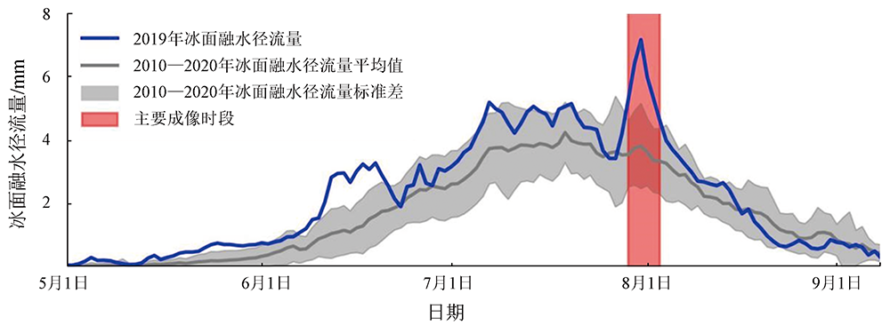
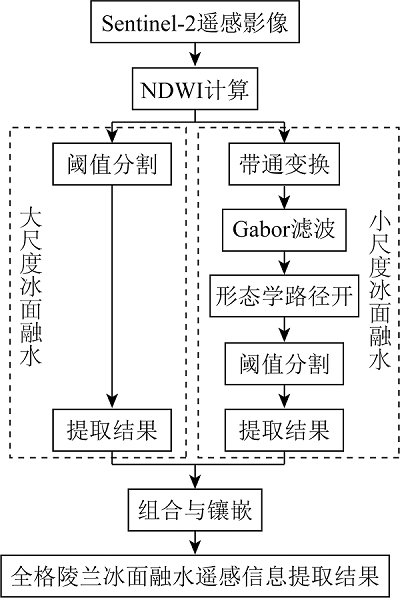
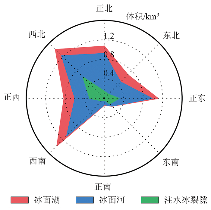
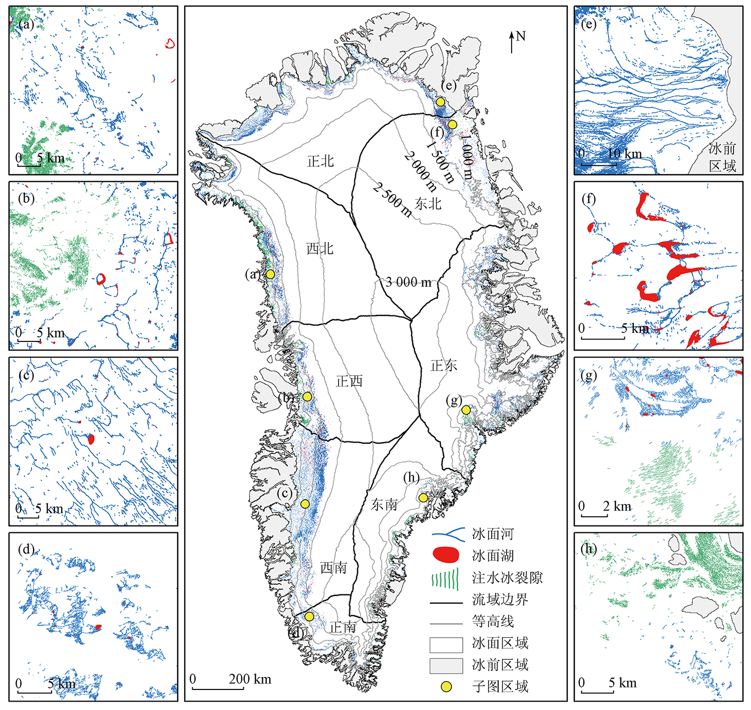
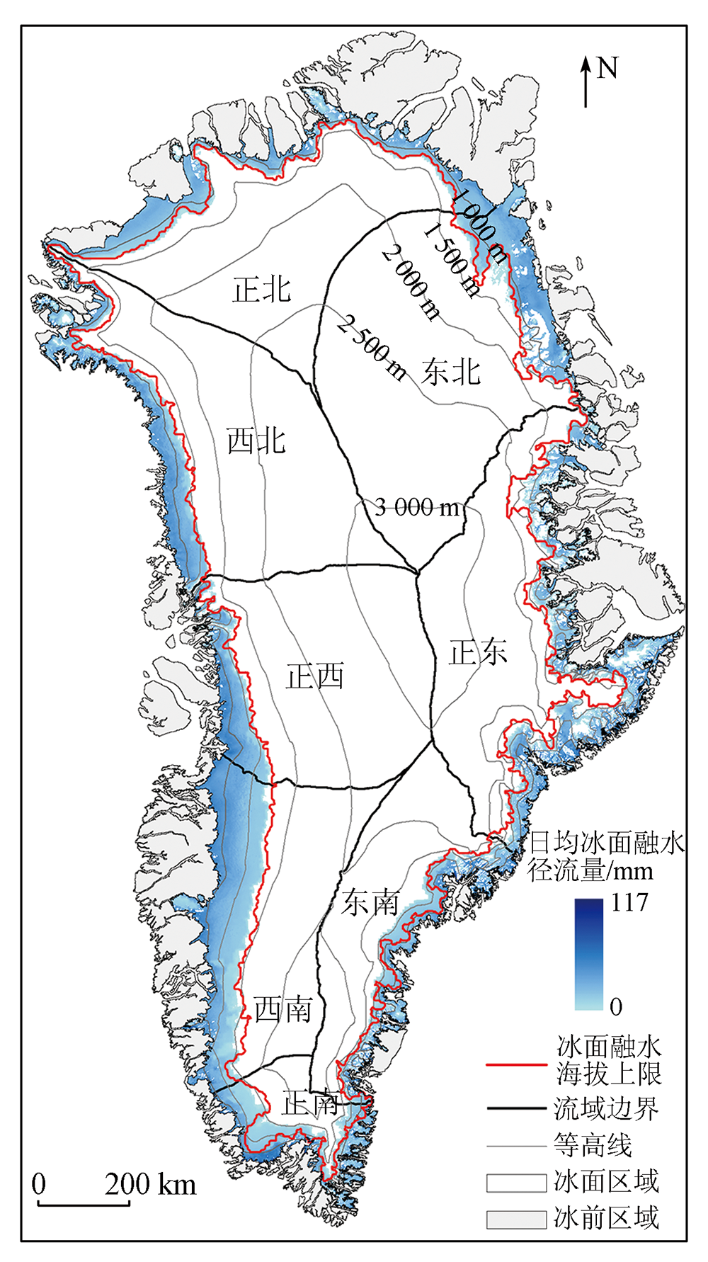
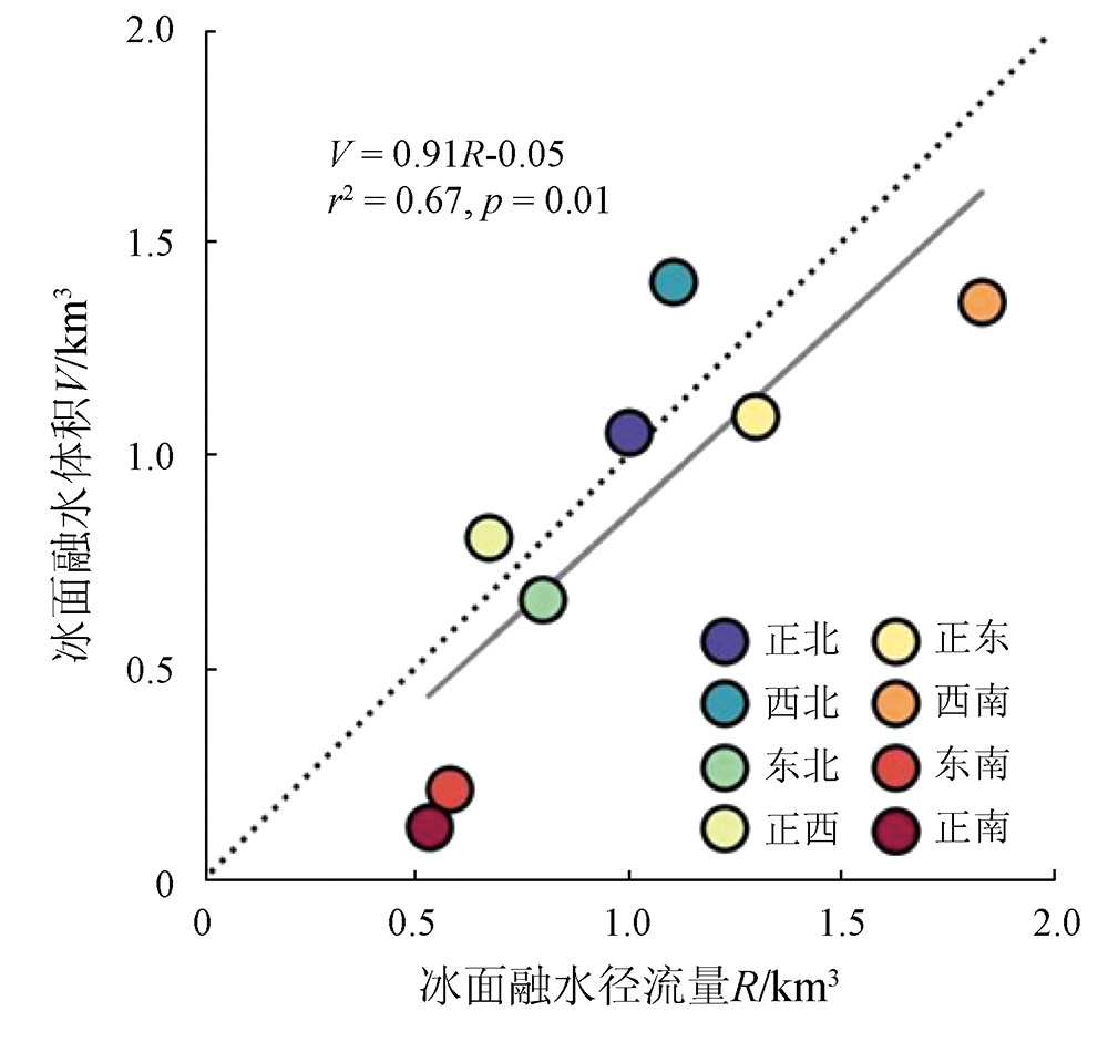
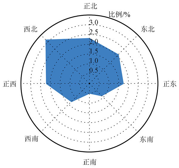
Abstract Every summer, the surface melting on the Greenland Ice Sheet (GrIS) results in a large amount of surface meltwater, which is transported via supraglacial rivers and stored supraglacial lakes and water-filled crevasses, forming a large-scale and complex hydrologic system. However, there is a lack of studies on the spatial distribution of surface meltwater on the GrIS. This study extracted the surface meltwater information of the GrIS during the peak melting period in 2019 using 134 scenes of 10-m-resolution Sentinel-2 satellite images. Furthermore, we compared the surface meltwater distribution derived from the remote sensing observation and the surface meltwater runoff simulated by the regional atmospheric climate model (RACMO). The results show that: ① During the peak melting period in 2019, the GrIS exhibited a surface meltwater area of 9 900.9 km2 and a surface meltwater volume of 6.8 km3; ② The GrIS surface meltwater exhibited a significantly varying spatial distribution characterized by high volumes in the western and northern basins and low volumes in the eastern and southern basins; ③ The surface meltwater on the GrIS was primarily composed of supraglacial rivers, which accounted for 57.1% of the overall surface meltwater volume, followed by water-filled crevasses (25.6%) and supraglacial lakes (17.3%); ④ RACMO accurately simulated the surface meltwater runoff regions in most GrIS basins. This study enhanced the understanding of key hydrologic processes such as surface meltwater routing and storage, demonstrating the high application potential of high-resolution remote sensing images in the hydrologic research of the GrIS.
|
| Keywords
supraglacial river
supraglacial lake
water-filled crevasse
Sentinel-2
Greenland Ice Sheet
|
|
|
|
Issue Date: 13 March 2024
|
|
|
| [1] |
Van Den Broeke M R, Enderlin E M, Howat I M, et al. On the recent contribution of the Greenland ice sheet to sea level change[J]. The Cryosphere, 2016, 10(5):1933-1946.
doi: 10.5194/tc-10-1933-2016
url: https://tc.copernicus.org/articles/10/1933/2016/
|
| [2] |
Shepherd A, Ivins E, Rignot E, et al. Mass balance of the Greenland ice sheet from 1992 to 2018[J]. Nature, 2020, 579(7798):233-239.
doi: 10.1038/s41586-019-1855-2
|
| [3] |
Rennermalm A K, Moustafa S E, Mioduszewski J, et al. Understanding Greenland ice sheet hydrology using an integrated multi-scale approach[J]. Environmental Research Letters, 2013, 8(1):015017.
doi: 10.1088/1748-9326/8/1/015017
url: https://iopscience.iop.org/article/10.1088/1748-9326/8/1/015017
|
| [4] |
Zwally H J, Abdalati W, Herring T, et al. Surface melt-induced acceleration of Greenland ice-sheet flow[J]. Science, 2002, 297(5579):218-222.
pmid: 12052902
|
| [5] |
Smith L C, Chu V W, Yang K, et al. Efficient meltwater drainage through supraglacial streams and rivers on the southwest Greenland ice sheet[J]. Proceedings of the National Academy of Sciences of the United States of America, 2015, 112(4):1001-1006.
doi: 10.1073/pnas.1413024112
pmid: 25583477
|
| [6] |
Das S B, Joughin I, Behn M D, et al. Fracture propagation to the base of the Greenland Ice Sheet during supraglacial lake drainage[J]. Science, 2008, 320(5877):778-781.
doi: 10.1126/science.1153360
pmid: 18420900
|
| [7] |
McGrath D, Colgan W, Steffen K, et al. Assessing the summer water budget of a moulin basin in the Sermeq Avannarleq ablation region,Greenland ice sheet[J]. Journal of Glaciology, 2011, 57(205):954-964.
doi: 10.3189/002214311798043735
url: https://www.cambridge.org/core/product/identifier/S0022143000205212/type/journal_article
|
| [8] |
Colgan W, Steffen K, Mclamb W S, et al. An increase in crevasse extent,West Greenland:Hydrologic implications[J]. Geophysical Research Letters, 2011, 38:L18502.
|
| [9] |
Hu J, Huang H, Chi Z, et al. Distribution and evolution of supraglacial lakes in Greenland during the 2016—2018 melt seasons[J]. Remote Sensing, 2021, 14(1):55.
doi: 10.3390/rs14010055
url: https://www.mdpi.com/2072-4292/14/1/55
|
| [10] |
Selmes N, Murray T, James T D. Fast draining lakes on the Greenland Ice Sheet[J]. Geophysical Research Letters, 2011, 38(15):L15501.
|
| [11] |
Dunmire D, Banwell A F, Wever N, et al. Contrasting regional variability of buried meltwater extent over 2 years across the Greenland ice sheet[J]. The Cryosphere, 2021, 15(6):2983-3005.
doi: 10.5194/tc-15-2983-2021
url: https://tc.copernicus.org/articles/15/2983/2021/
|
| [12] |
Chudley T R, Christoffersen P, Doyle S H, et al. Controls on water storage and drainage in crevasses on the Greenland Ice Sheet[J]. Journal of Geophysical Research:Earth Surface, 2021, 126: e2021JF006287.
|
| [13] |
Yang K, Smith L C, Sole A, et al. Supraglacial rivers on the northwest Greenland Ice Sheet,Devon Ice Cap,and Barnes ice cap mapped using Sentinel-2 imagery[J]. International Journal of Applied Earth Observation and Geoinformation, 2019, 78:1-13.
doi: 10.1016/j.jag.2019.01.008
url: https://linkinghub.elsevier.com/retrieve/pii/S0303243418306895
|
| [14] |
Tedstone A J, Machguth H. Increasing surface runoff from Greenland’s firn areas[J]. Nature Climate Change, 2022, 12:672-676.
doi: 10.1038/s41558-022-01371-z
pmid: 35811787
|
| [15] |
Fettweis X, Hofer S, Krebs-Kanzow U, et al. GrSMBMIP:intercomparison of the modelled 1980—2012 surface mass balance over the Greenland Ice Sheet[J]. The Cryosphere, 2020, 14(11):3935-58.
doi: 10.5194/tc-14-3935-2020
url: https://tc.copernicus.org/articles/14/3935/2020/
|
| [16] |
Noël B, Van De Berg W J, Van Wessem J M, et al. Modelling the climate and surface mass balance of polar ice sheets using RACMO2-Part 1:Greenland (1958—2016)[J]. The Cryosphere,2018, 12(3):811-31.
doi: 10.5194/tc-12-811-2018
url: https://tc.copernicus.org/articles/12/811/2018/
|
| [17] |
Howat I M. MEaSUREs Greenland Ice Mapping Project (GIMP) land ice and ocean classification mask,Version 1[Z].Boulder,Colorado USA:NASA National Snow and Ice Data Center Distributed Active Archive Center, 2017.
|
| [18] |
Cheng D, Hayes W, Larour E, et al. Calving Front Machine (CALFIN):Glacial termini dataset and automated deep learning extraction method for Greenland,1972—2019[J]. The Cryosphere, 2021, 15(3):1663-1675.
doi: 10.5194/tc-15-1663-2021
url: https://tc.copernicus.org/articles/15/1663/2021/
|
| [19] |
Morlighem M, Williams C N, Rignot E, et al. Icebridge Bed Machine Greenland,version 4[Z].Boulder,Colorado USA:NASA National Snow and Ice Data Center Distributed Active Archive Center, 2021.
|
| [20] |
Joughin I. MEaSUREs Greenland annual ice sheet velocity mosaics from SAR and Landsat,Version 3[Z].Boulder,Colorado USA:NASA National Snow and Ice Data Center Distributed Active Archive Center, 2021.
|
| [21] |
Mcfeeters S K. The use of the normalized difference water index (NDWI) in the delineation of open water features[J]. International Journal of Remote Sensing, 1996, 17(7):1425-1432.
doi: 10.1080/01431169608948714
url: https://www.tandfonline.com/doi/full/10.1080/01431169608948714
|
| [22] |
Heijmans H, Buckley M, Talbot H. Path openings and closings[J]. Journal of Mathematical Imaging and Vision, 2005, 22(2):107-119.
doi: 10.1007/s10851-005-4885-3
url: http://link.springer.com/10.1007/s10851-005-4885-3
|
| [23] |
Burgess D O, Sharp M J, Mair D W F, et al. Flow dynamics and iceberg calving rates of Devon Ice Cap,Nunavut,Canada[J]. Journal of Glaciology, 2005, 51(173):219-230.
doi: 10.3189/172756505781829430
url: https://www.cambridge.org/core/product/identifier/S0022143000214858/type/journal_article
|
| [24] |
Williamson A G, Banwell A F, Willis I C, et al. Dual-satellite (Sentinel-2 and Landsat 8) remote sensing of supraglacial lakes in Greenland[J]. The Cryosphere, 2018, 12(9):3045-3065.
doi: 10.5194/tc-12-3045-2018
url: https://tc.copernicus.org/articles/12/3045/2018/
|
| [25] |
Corr D, Leeson A, McMillan M, et al. An inventory of supraglacial lakes and channels across the West Antarctic ice sheet[J]. Earth System Science Data, 2022, 14(1):209-228.
doi: 10.5194/essd-14-209-2022
url: https://essd.copernicus.org/articles/14/209/2022/
|
| [26] |
Fitzpatrick A A W, Hubbard A L, Box J E, et al. A decade (2002—2012) of supraglacial lake volume estimates across Russell Glacier,West Greenland[J]. The Cryosphere,2014, 8(1):107-121.
doi: 10.5194/tc-8-107-2014
url: https://tc.copernicus.org/articles/8/107/2014/
|
| [27] |
Leeson A A, Shepherd A, Briggs K, et al. Supraglacial lakes on the Greenland ice sheet advance inland under warming climate[J]. Nature Climate Change, 2015, 5(1):51-55.
doi: 10.1038/nclimate2463
|
| [28] |
Yang K, Smith L C, Cooper M G, et al. Seasonal evolution of supraglacial lakes and rivers on the southwest Greenland Ice Sheet[J]. Journal of Glaciology, 2021, 67(264):592-602.
doi: 10.1017/jog.2021.10
url: https://www.cambridge.org/core/product/identifier/S0022143021000101/type/journal_article
|
| [29] |
Muthyala R, Rennermalm A, Leidman S, et al. Supraglacial streamflow and meteorological drivers from southwest Greenland[J]. The Cryosphere, 2022, 16(6):2245-2263.
doi: 10.5194/tc-16-2245-2022
url: https://tc.copernicus.org/articles/16/2245/2022/
|
| [30] |
李岚静, 陈卓奇, 郑雷, 等. 格陵兰冰盖次表面湖多源遥感监测——以格陵兰中西部流域为例[J]. 地球物理学报, 2022, 65(10):3818-28.
|
| [30] |
Li L J, Chen Z Q, Zheng L, et al. Extraction of Greenland Ice Sheet buried lakes using multi-source remote sensing data:With application to the central west basin of Greenland[J]. Chinese Journal of Geophysics, 2022, 65(10):3818-3828.
|
| [31] |
Jiang D, Li X, Zhang K, et al. Automatic supraglacial lake extraction in Greenland using Sentinel-1 SAR images and attention-based U-Net[J]. Remote Sensing, 2022, 14(19):4998.
doi: 10.3390/rs14194998
url: https://www.mdpi.com/2072-4292/14/19/4998
|
| [32] |
Schröder L, Neckel N, Zindler R, et al. Perennial supraglacial lakes in Northeast Greenland observed by polarimetric SAR[J]. Remote Sensing, 2020, 12(17):2798.
doi: 10.3390/rs12172798
url: https://www.mdpi.com/2072-4292/12/17/2798
|
| [33] |
Ignéczi Á, Sole A J, Livingstone S J, et al. Northeast sector of the Greenland ice sheet to undergo the greatest inland expansion of supraglacial lakes during the 21st century[J]. Geophysical Research Letters, 2016, 43(18):9729-9738.
doi: 10.1002/grl.v43.18
url: https://agupubs.onlinelibrary.wiley.com/toc/19448007/43/18
|
| [34] |
Miège C, Forster R R, Brucker L, et al. Spatial extent and temporal variability of Greenland firn aquifers detected by ground and airborne radars[J]. Journal of Geophysical Research:Earth Surface, 2016, 121(12):2381-2398.
doi: 10.1002/jgrf.v121.12
url: https://agupubs.onlinelibrary.wiley.com/toc/21699011/121/12
|
| [35] |
Ryan J C, Smith L C, Van As D, et al. Greenland ice sheet surface melt amplified by snowline migration and bare ice exposure[J]. Science Advances, 2019, 5(3):eaav3738.
doi: 10.1126/sciadv.aav3738
url: https://www.science.org/doi/10.1126/sciadv.aav3738
|
| [36] |
Miller J Z, Culberg R, Long D G, et al. An empirical algorithm to map perennial firn aquifers and ice slabs within the Greenland Ice Sheet using satellite L-band microwave radiometry[J]. The Cryosphere, 2022, 16(1):103-125.
doi: 10.5194/tc-16-103-2022
url: https://tc.copernicus.org/articles/16/103/2022/
|
|
Viewed |
|
|
|
Full text
|
|
|
|
|
Abstract
|
|
|
|
|
Cited |
|
|
|
|
| |
Shared |
|
|
|
|
| |
Discussed |
|
|
|
|
 2024,
Vol. 36
2024,
Vol. 36