|
|
 |
|

|
|
|
Extracting the information on sloping arable land based on improved DexiNed and DeepLabv3+ networks in a cascade connection |
LIU Chaobing1( ), GAN Shu1,2(), YUAN Xiping3,4, SHANG Huasheng1 ), GAN Shu1,2(), YUAN Xiping3,4, SHANG Huasheng1 |
1. School of Land Resources Engineering, Kunming University of Science and Technology, Kunming 650093, China
2. Application Engineering Research Center of Spatial Information Surveying and Mapping Technology in Plateau and Mountainous Areas Set by Universities in Yunnan Province, Kunmin 650093,China
3. School of Earth Sciences and Engineering, West Yunnan University of Applied Sciences, Dali 671006, China
4. Key Laboratory of Mountain Real Scene Point Cloud Data Processing and Application for Universities in Yunnan Province, Dali 671006, China |
|
|
|
|
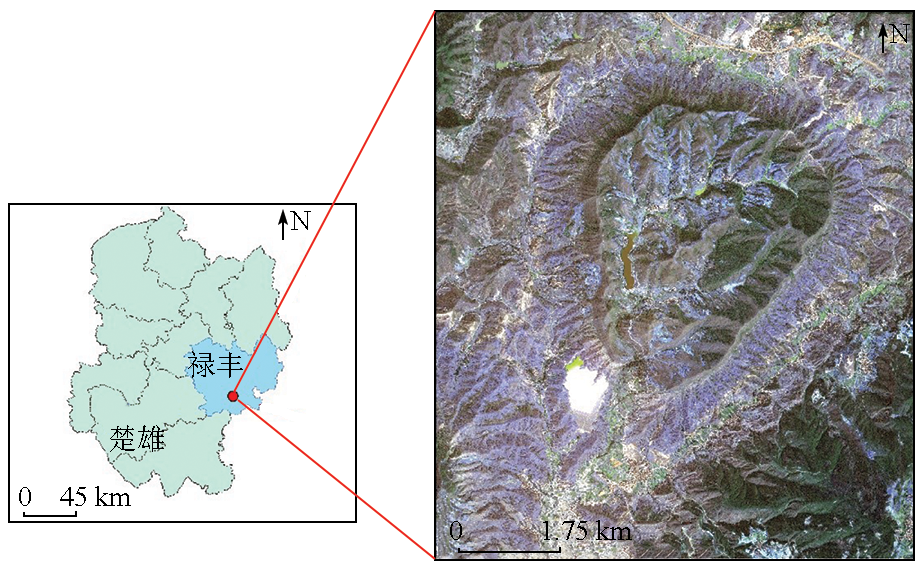
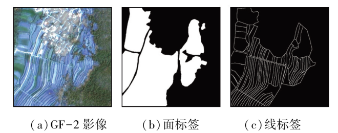
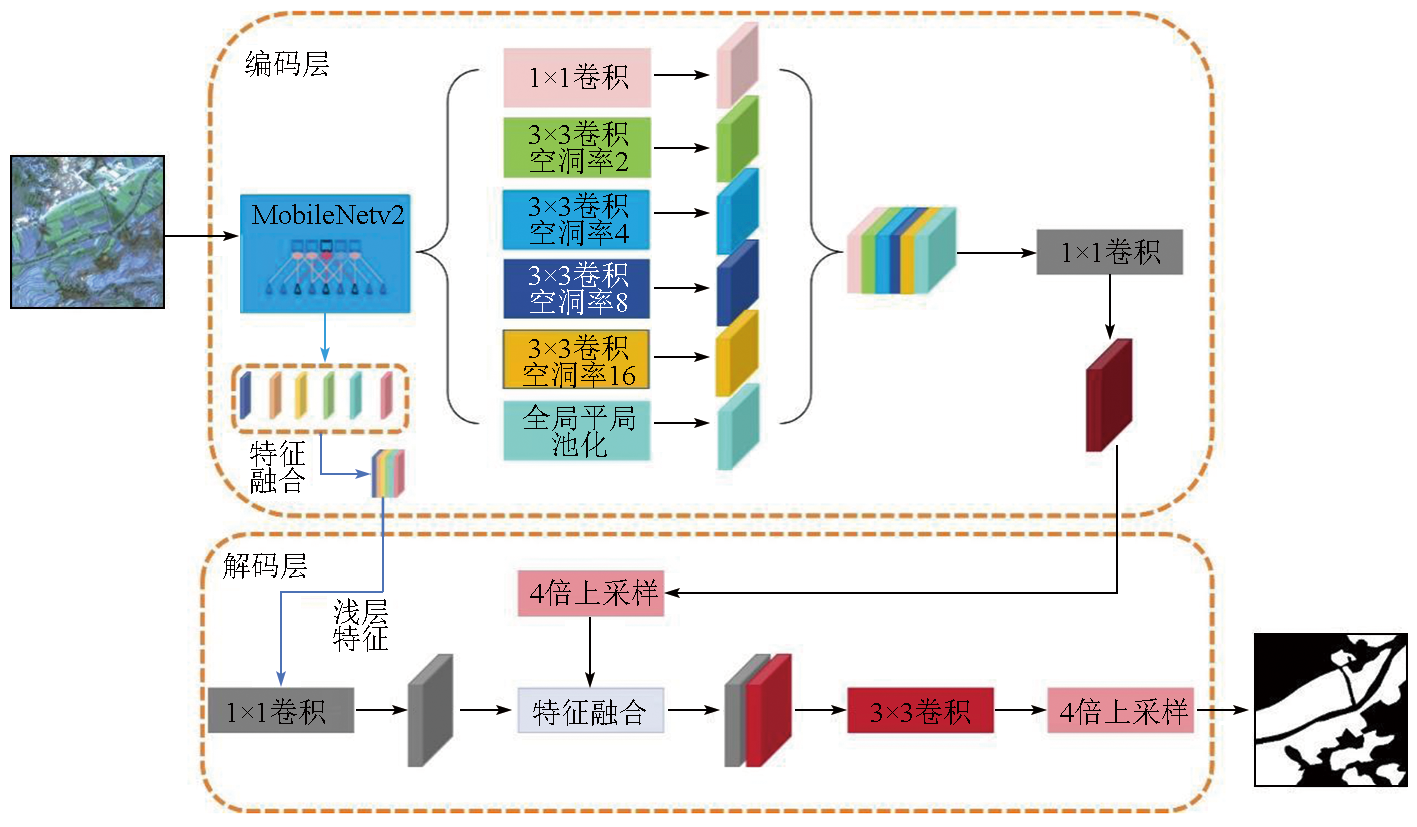
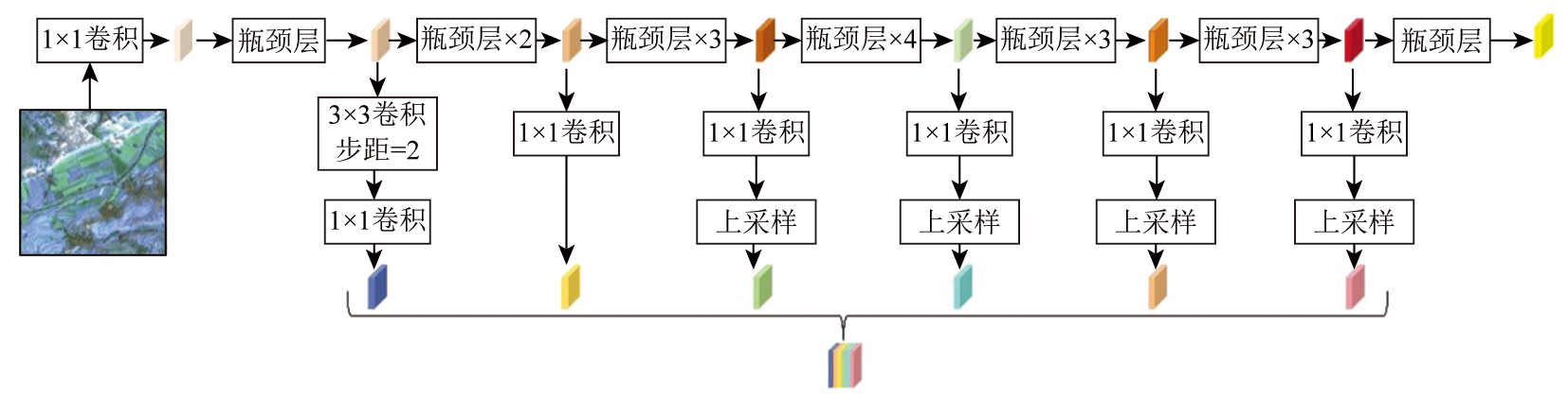
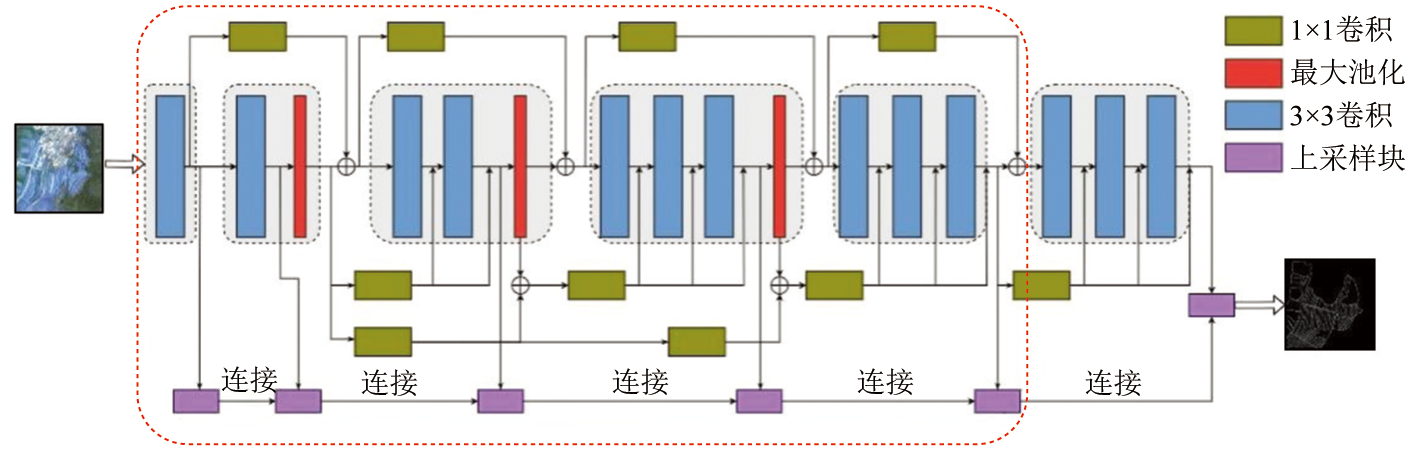
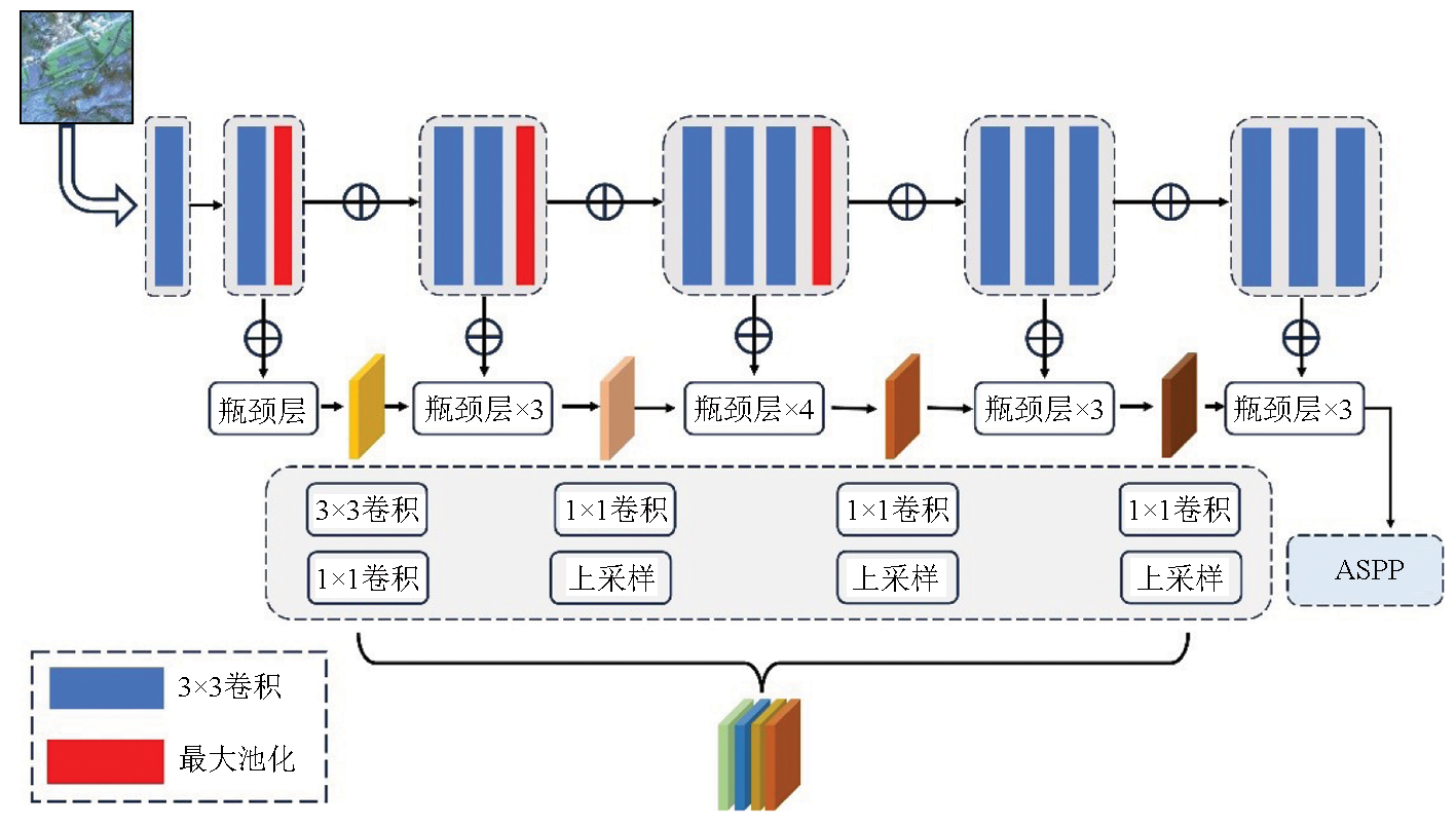
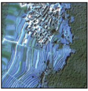
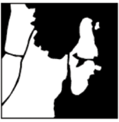
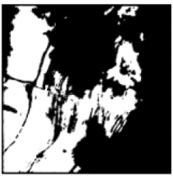
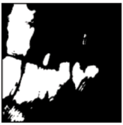
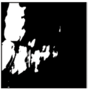
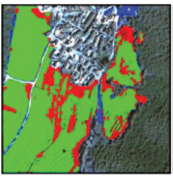
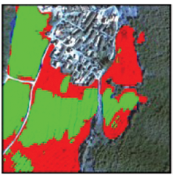
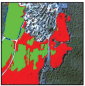
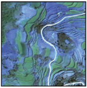
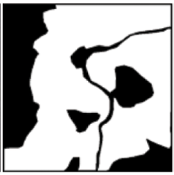
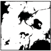
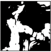
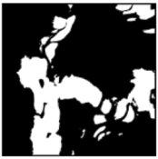
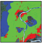
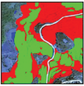
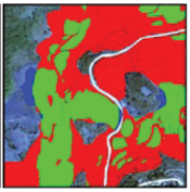
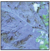
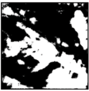
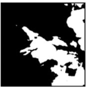
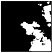
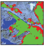
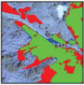
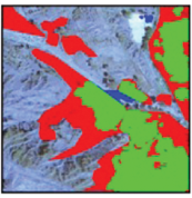
Abstract Arable land in hilly and mountainous areas exhibits small, narrow, and complex structures with blurred boundaries, posing challenges in extracting arable land information quickly and accurately. Hence, this study proposed a model for extracting the information on sloping arable land based on improved DexiNed and DeepLabv3+ networks in a cascade connection. First, the backbone network of the DeepLabv3+ model uses MobileNetV2 to replace the original Xception model. A closely related low-level information extraction method preliminarily fuses the lower- and higher-level information as the input of the original low-level information. Second, the original atrous spatial pyramid pooling (ASPP) module of the DeepLabv3+ model is optimized through dilated convolution, with dilation rate values of 2, 4, 8, and 16. Third, cascaded edge detection technology enables the interconnection of arable land edges and semantic features. The proposed model was applied to extract information on arable land in the Lufeng Dinosaur Valley in Yunnan Province using the GF-2 image as the data source. The results show that the proposed model with an improved architecture and algorithm identified the arable land more accurately, with the extraction results closely matching the image with real arable land annotated. With reduced extraction missing and errors, the proposed model exhibits enhanced accuracy and stability overall.
|
| Keywords
extraction of arable land information
edge detection
DeepLabv3+
hilly and mountainous areas
|
|
|
|
Issue Date: 09 May 2025
|
|
|
| [1] |
吴炳方, 张峰, 刘成林, 等. 农作物长势综合遥感监测方法[J]. 遥感学报, 2004, 8(6):498-514.
|
| [1] |
Wu B F, Zhang F, Liu C L, et al. An integrated method for crop condition monitoring[J]. Journal of Remote Sensing, 2004, 8(6):498-514.
|
| [2] |
陈仲新, 任建强, 唐华俊, 等. 农业遥感研究应用进展与展望[J]. 遥感学报, 2016, 20(5):748-767.
|
| [2] |
Chen Z X, Ren J Q, Tang H J, et al. Progress and perspectives on agricultural remote sensing research and applications in China[J]. Journal of Remote Sensing, 2016, 20(5):748-767.
|
| [3] |
史舟, 梁宗正, 杨媛媛, 等. 农业遥感研究现状与展望[J]. 农业机械学报, 2015, 46(2):247-260.
|
| [3] |
Shi Z, Liang Z Z, Yang Y Y, et al. Status and prospect of agricultural remote sensing[J]. Transactions of the Chinese Society for Agricultural Machinery, 2015, 46(2):247-260.
|
| [4] |
刘大伟, 韩玲, 韩晓勇. 基于深度学习的高分辨率遥感影像分类研究[J]. 光学学报, 2016, 36(4):0428001.
|
| [4] |
Liu D W, Han L, Han X Y. High spatial resolution remote sensing image classification based on deep learning[J]. Acta Optica Sinica, 2016, 36(4):0428001.
|
| [5] |
张新长, 黄健锋, 宁婷. 高分辨率遥感影像耕地提取研究进展与展望[J]. 武汉大学学报(信息科学版), 2023, 48(10):1582-1590.
|
| [5] |
Zhang X C, Huang J F, Ning T. Progress and prospect of cultivated land extraction from high-resolution remote sensing images[J]. Geomatics and Information Science of Wuhan University, 2023, 48(10):1582-1590.
|
| [6] |
熊曦柳, 胡月明, 文宁, 等. 耕地遥感识别研究进展与展望[J]. 农业资源与环境学报, 2020, 37(6):856-865.
|
| [6] |
Xiong X L, Hu Y M, Wen N, et al. Progress and prospect of cultivated land extraction research using remote sensing[J]. Journal of Agricultural Resources and Environment, 2020, 37(6):856-865.
|
| [7] |
李爱农, 边金虎, 张正健, 等. 山地遥感主要研究进展、发展机遇与挑战[J]. 遥感学报, 2016, 20(5):1199-1215.
|
| [7] |
Li A N, Bian J H, Zhang Z J, et al. Progresses,opportunities,and challenges of mountain remote sensing research[J]. Journal of Remote Sensing, 2016, 20(5):1199-1215.
|
| [8] |
周楠, 杨鹏, 魏春山, 等. 地块尺度的山区耕地精准提取方法[J]. 农业工程学报, 2021, 37(19):260-266.
|
| [8] |
Zhou N, Yang P, Wei C S, et al. Accurate extraction method for cropland in mountainous areas based on field parcel[J]. Transactions of the Chinese Society of Agricultural Engineering, 2021, 37(19):260-266.
|
| [9] |
Dong S, Wang P, Abbas K. A survey on deep learning and its applications[J]. Computer Science Review, 2021, 40:100379.
|
| [10] |
Ma L, Liu Y, Zhang X, et al. Deep learning in remote sensing applications:A meta-analysis and review[J]. ISPRS Journal of Photogrammetry and Remote Sensing, 2019, 152:166-177.
|
| [11] |
刘巍, 吴志峰, 骆剑承, 等. 深度学习支持下的丘陵山区耕地高分辨率遥感信息分区分层提取方法[J]. 测绘学报, 2021, 50(1):105-116.
doi: 10.11947/j.AGCS.2021.20190448
|
| [11] |
Liu W, Wu Z F, Luo J C, et al. A divided and stratified extraction method of high-resolution remote sensing information for cropland in hilly and mountainous areas based on deep learning[J]. Acta Geodaetica et Cartographica Sinica, 2021, 50(1):105-116.
doi: 10.11947/j.AGCS.2021.20190448
|
| [12] |
Xie S, Tu Z. Holistically-nested edge detection[C]// 2015 IEEE International Conference on Computer Vision (ICCV).Santiago,Chile.IEEE, 2015:1395-1403.
|
| [13] |
Zhao W D, Zhang Y, Zhang D D, et al. Refined edge detection model based on RCF[J]. Journal of Measurement Science and Instrumentation, 2024, 15(2):195-203.
|
| [14] |
Zhou L, Zhang C, Wu M. D-LinkNet:LinkNet with pretrained encoder and dilated convolution for high resolution satellite imagery road extraction[C]// 2018 IEEE/CVF Conference on Computer Vision and Pattern Recognition Workshops (CVPRW).Salt Lake City,UT,USA.IEEE, 2018:192-1924.
|
| [15] |
Ronneberger O, Fischer P, Brox T. U-net:Convolutional networks for biomedical image segmentation[C]// International Conference on Medical Image Computing and Computer-Assisted Intervention. Cham:Springer, 2015:234-241.
|
| [16] |
Xia L, Luo J, Sun Y, et al. Deep extraction of cropland parcels from very high-resolution remotely sensed imagery[C]// 2018 7th International Conference on Agro-Geoinformatics (Agro-geoinformatics). Hangzhou,China.IEEE, 2018:1-5.
|
| [17] |
Diao Z, Guo P, Zhang B, et al. Maize crop row recognition algorithm based on improved UNet network[J]. Computers and Electronics in Agriculture, 2023, 210:107940.
|
| [18] |
Liu S, Liu L, Xu F, et al. A deep learning method for individual arable field (IAF) extraction with cross-domain adversarial capabi-lity[J]. Computers and Electronics in Agriculture, 2022, 203:107473.
|
| [19] |
Zhu M, Yao M, He Y, et al. Studies on high-resolution remote sensing sugarcane field[J]. IOP Conference Series: Earth and environmental science, 2019, 237: 32046.
|
| [20] |
高莎, 袁希平, 甘淑, 等. 基于无人机成像点云的禄丰恐龙谷南缘环状地貌空间特征探测实验分析[J]. 地质科技通报, 2021, 40(6):283-292.
|
| [20] |
Gao S, Yuan X P, Gan S, et al. Experimental analysis of spatial feature detection of the ring geomorphology at the south edge of Lufeng Dinosaur Valley based on UAV imaging point cloud[J]. Bulletin of Geological Science and Technology, 2021, 40(6):283-292.
|
| [21] |
陈佳俊. 基于GF-2卫星影像的川东丘陵地区耕地信息提取[D]. 成都: 成都理工大学, 2017.
|
| [21] |
Chen J J. Extraction of cultivated land information in hilly area of East Sichuan based on GF-2 satellite image[D]. Chengdu: Chengdu University of Technology, 2017.
|
| [22] |
Sandler M, Howard A, Zhu M, et al. MobileNetV2:Inverted residuals and linear bottlenecks[C]// 2018 IEEE/CVF Conference on Computer Vision and Pattern Recognition.Salt Lake City,UT,USA.IEEE, 2018:4510-4520.
|
| [23] |
Chollet F. Xception:Deep learning with depthwise separable convolutions[C]// 2017 IEEE Conference on Computer Vision and Pattern Recognition (CVPR).Honolulu,HI,USA.IEEE, 2017:1800-1807.
|
| [24] |
Soria X, Sappa A, Humanante P, et al. Dense extreme inception network for edge detection[J]. Pattern Recognition, 2023, 139:109461.
|
|
Viewed |
|
|
|
Full text
|
|
|
|
|
Abstract
|
|
|
|
|
Cited |
|
|
|
|
| |
Shared |
|
|
|
|
| |
Discussed |
|
|
|
|
 2025,
Vol. 37
2025,
Vol. 37