|
|
|
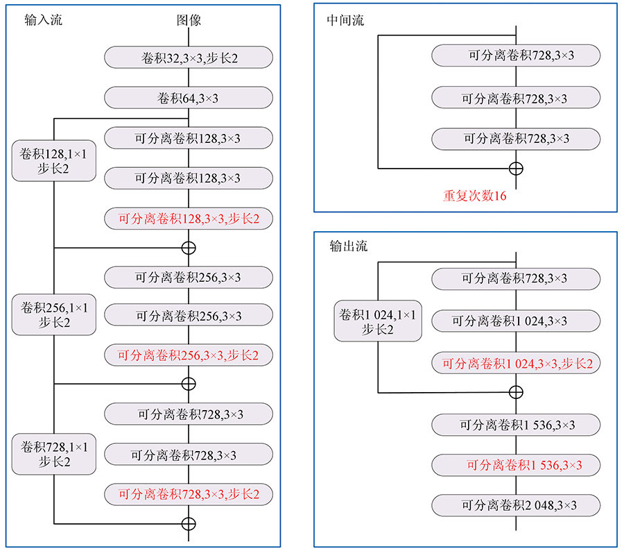
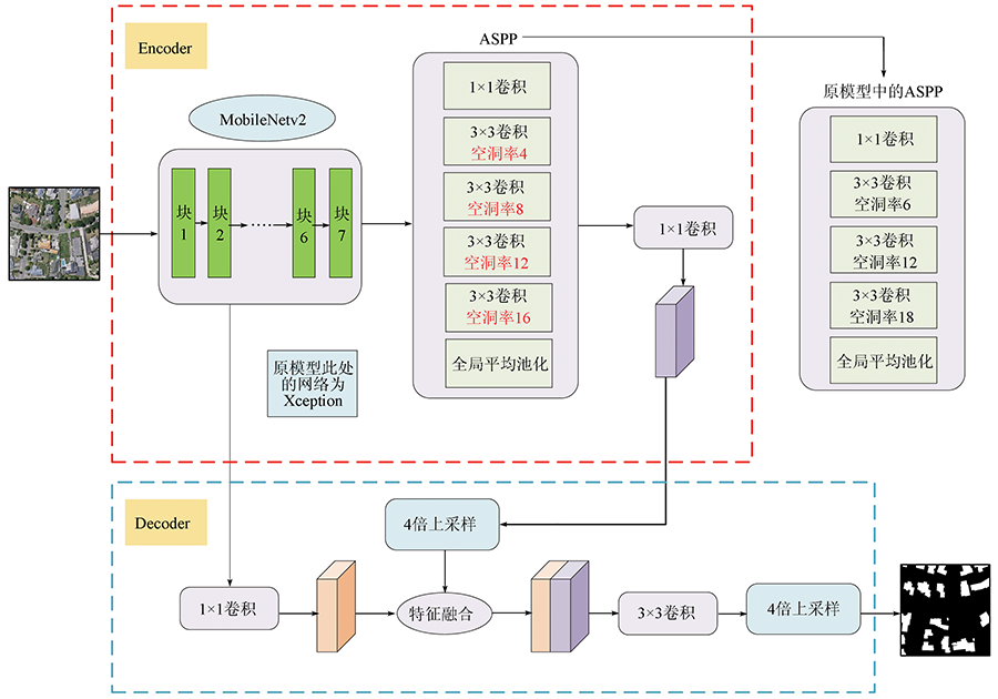
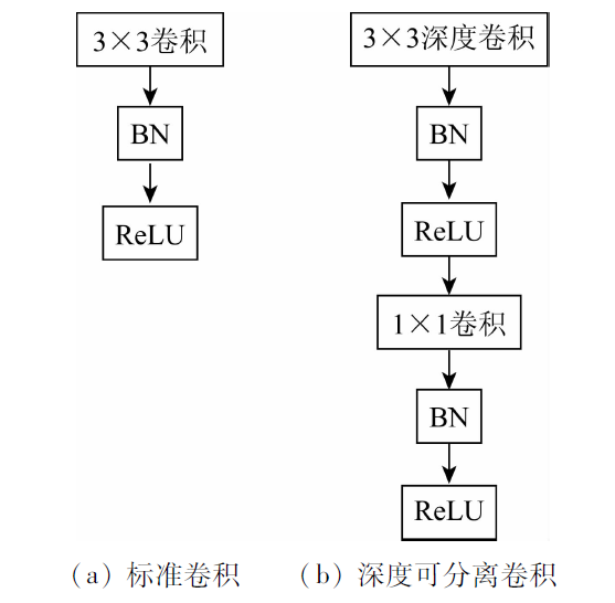
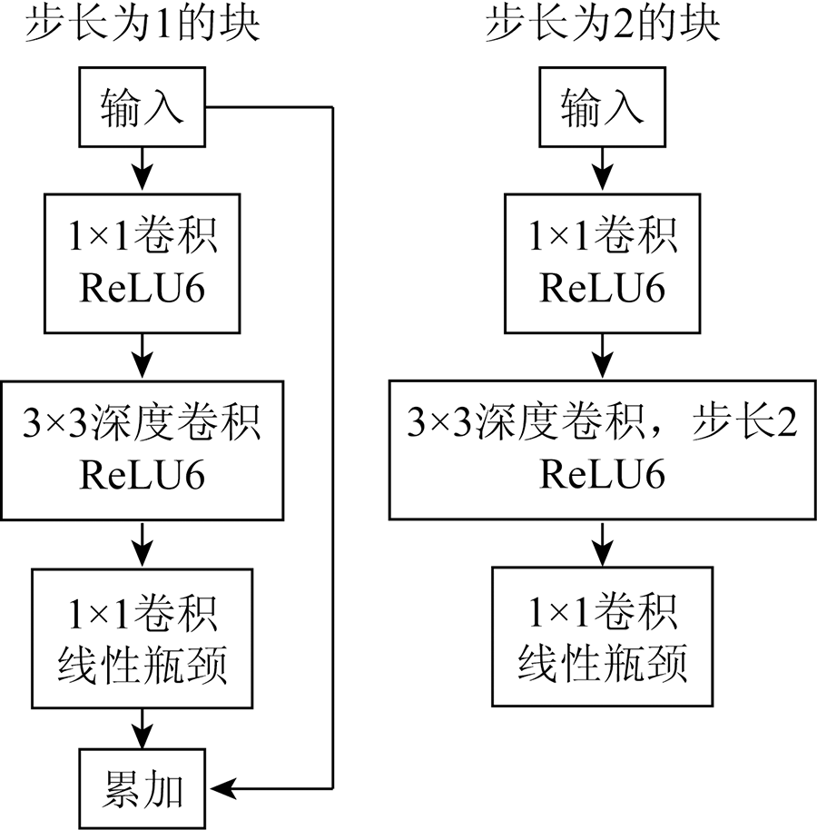
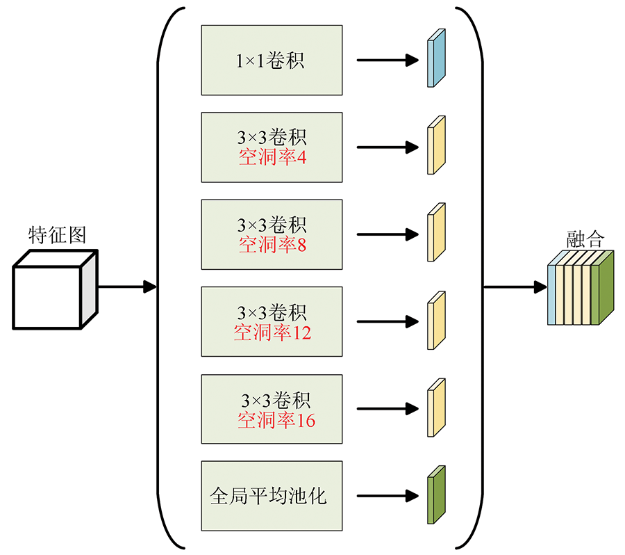
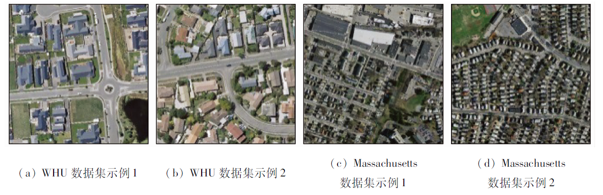
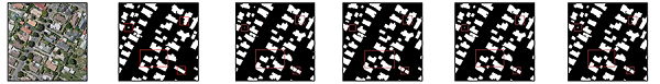
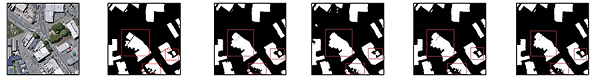
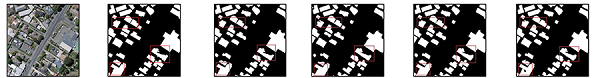
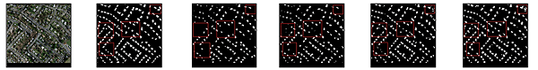
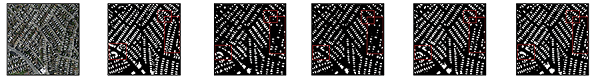
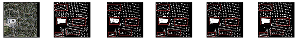
Abstract Fast extraction of buildings with high accuracy from remote sensing images is an important research of remote sensing intelligent application services. To address the problems of imprecise segmentation of building edge in remote sensing images, holes in large-scale target segmentation, and a large amount of network parameters in the DeepLab model, a lightweight DeepLabv3+ model for building extraction from remote sensing images is proposed. In this method, the lightweight network MobileNetv2 is used to replace Xception, the backbone network of DeepLabv3+, so as to reduce the number of parameters and improve the training speed; The hole rate of hole convolution in ASPP is optimized to improve the effect of multi-scale semantic feature extraction. The improved model has been tested on WHU and Massachusetts data sets. The results show that the IOU and F1 score in WHU dataset are 82.37% and 92.89%, respectively, 2.71 percentage points and 2.14 percentage points higher than those of DeepLabv3+, 2.04 percentage points, and 2.32 percentage points higher than those of DeepLabv3+ in Massachusetts data set. The number of training parameters and training time is reduced, and the accuracy of the building extraction is effectively improved, which can meet the requirements of fast extraction of high-precision buildings.
|
| Keywords
deep learning
semantic segmentation
improved ASPP
DeepLabv3+
MobileNetv2
|
|
|
|
Corresponding Authors:
GE Xiaosan
E-mail: 1029803406@qq.com;gexiaosan@163.com
|
|
Issue Date: 20 June 2022
|
|
|
| [1] |
范荣双, 陈洋, 徐启恒, 等. 基于深度学习的高分辨率遥感影像建筑物提取方法[J]. 测绘学报, 2019, 48(1):34-41.
|
| [1] |
Fan R S, Chen Y, Xu Q H, et al. A high-resolution remote sensing image building extraction method based on deep learning[J]. Acta Geodaetica et Cartographica Sinica, 2019, 48(1):34-41.
|
| [2] |
张浩然, 赵江洪, 张晓光. 利用U-net网络的高分遥感影像建筑提取方法[J]. 遥感信息, 2020, 35(3):143-150.
|
| [2] |
Zhang H R, Zhao J H, Zhang X G. High-resolution image building extraction using U-net neural network[J]. Remote Sensing Information, 2020, 35(3):143-150.
|
| [3] |
许泽宇, 沈占锋, 李杨, 等. 结合模糊度和形态学指数约束的深度学习建筑物提取[J]. 地球信息科学学报, 2021, 23(5):918-927.
doi: 10.12082/dqxxkx.2021.200397
|
| [3] |
Xu Z Y, Shen Z F, Li Y, et al. Building extraction by deep learning method combined with ambiguity and morphological index constraints[J]. Journal of Geo-Information Science, 2021, 23(5):918-927.
|
| [4] |
唐璎, 刘正军, 杨懿, 等. 基于特征增强和ELU的神经网络建筑物提取研究[J]. 地球信息科学学报, 2021, 23(4):692-709.
doi: 10.12082/dqxxkx.2021.200130
|
| [4] |
Tang Y, Liu Z J, Yang Y, et al. Research on building extraction based on neural network with feature enhancement and ELU activation function[J]. Journal of Geo-Information Science, 2021, 23(4):692-709.
|
| [5] |
刘亦凡, 张秋昭, 王光辉, 等. 利用深度残差网络的遥感影像建筑物提取[J]. 遥感信息, 2020, 35(2):59-64.
|
| [5] |
Liu Y F, Zhang Q Z, Wang G H, et al. Building extraction in remote sensing imagery based on deep residual network[J]. Remote Sensing Information, 2020, 35(2):59-64.
|
| [6] |
陈凯强, 高鑫, 闫梦龙, 等. 基于编解码网络的航空影像像素级建筑物提取[J]. 遥感学报, 2020, 24(9):1134-1142.
|
| [6] |
Chen K Q, Gao X, Yan M L, et al. Building extraction in pixel level from aerial imagery with a deep encoder-decoder network[J]. Journal of Remote Sensing, 2020, 24(9):1134-1142.
|
| [7] |
叶沅鑫, 谭鑫, 孙苗苗, 等. 基于增强DeepLabV3网络的高分辨率遥感影像分类[J]. 测绘通报, 2021(4):40-44.
|
| [7] |
Ye Y X, Tan X, Sun M M, et al. High-resolution remote sensing image classification based on improved DeepLabV3 network[J]. Bulletin of Surveying and Mapping, 2021(4):40-44.
|
| [8] |
Lecun Y, Bottou L. Gradient-based learning applied to document recognition[J]. Proceedings of the IEEE, 1998, 86(11):2278-2324.
doi: 10.1109/5.726791
url: http://ieeexplore.ieee.org/document/726791/
|
| [9] |
Krizhevsky A, Sutskever I, Hinton G. ImageNet classification with deep convolutional neural networks[J]. Advances in Neural Information Processing Systems, 2012, 25(2):1097-1105.
|
| [10] |
Simonyan K, Zisserman A. Very deep convolutional networks for large-scale image recognition[J]. Computer Science, 2014:1409-1556.
|
| [11] |
He K M, Zhang X Y, Ren S Q, et al. Deep residual learning for image recognition[EB/OL].(2015-12-10)[2021-05-12]. https://arxiv.org/abs/1512.03385.
url: https://arxiv.org/abs/1512.03385
|
| [12] |
Iandola F N, Han S, Moskewicz M W, et al. SqueezeNet:AlexNet-level accuracy with 50x fewer parameters and <0.5 MB model size[EB/OL].(2016-11-04)[2021-05-12]. https://arxiv.org/abs/1602.07360.
url: https://arxiv.org/abs/1602.07360
|
| [13] |
Tan M, Chen B, Pang R, et al. MnasNet:Platform-aware neural architecture search for mobile[C]// 2019 IEEE/CVF Conference on Computer Vision and Pattern Recognition,IEEE, 2019:2820-2828.
|
| [14] |
Howard A G, Zhu M, Chen B, et al. MobileNets:Efficient convolutional neural networks for mobile vision applications[EB/OL].(2017-04-17)[2021-05-12]. https://arxiv.org/abs/1704.04861.
url: https://arxiv.org/abs/1704.04861
|
| [15] |
Chen L C, Papandreou G, Kokkinos I, et al. Semantic image segmentation with deep convolutional nets and fully connected CRFs[J]. Computer Science, 2014(4):357-361.
|
| [16] |
Chen L C, Papandreou G, Kokkinos I, et al. DeepLab:Semantic image segmentation with deep convolutional nets,atrous convolution,and fully connected CRFs[J]. IEEE Transactions on Pattern Analysis and Machine Intelligence, 2018, 40(4):834-848.
doi: 10.1109/TPAMI.2017.2699184
url: http://ieeexplore.ieee.org/document/7913730/
|
| [17] |
Chen L C, Zhu Y, Papandreou G, et al. Encoder-decoder with atrous separable convolution for semantic image segmentation[C]// Conference on Computer Vision(ECCV), 2018:801-818.
|
| [18] |
王俊强, 李建胜, 周华春, 等. 基于DeepLabv3+与CRF的遥感影像典型要素提取方法[J]. 计算机工程, 2019, 45(10):260-265,271.
|
| [18] |
Wang J Q, Li J S, Zhou H C, et al. Typical element extraction method of remote sensing image based on DeepLabv3+ and CRF[J]. Computer Engineering, 2019, 45(10):260-265,271.
|
| [19] |
刘文祥, 舒远仲, 唐小敏, 等. 采用双注意力机制DeepLabv3+算法的遥感影像语义分割[J]. 热带地理, 2020, 40(2):303-313.
|
| [19] |
Liu W X, Shu Y Z, Tang X M, et al. Remote sensing image segmentation using dual attention mechanism DeepLabv3+ algorithm[J]. Tropical Geography, 2020, 40(2):303-313.
|
| [20] |
Sandler M, Howard A, Zhu M, et al. Mobilenetv2:Inverted residuals and linear bottlenecks[C]// Proceedings of the IEEE Conference on Computer Vision and Pattern Recognition.Piscataway:IEEE, 2018:4510-4520.
|
| [21] |
Chollet F. Xception:Deep learning with depthwise separable convolutions[C]// 2017 IEEE Conference on Computer Vision and Pattern Recognition, 2017:1800-1807.
|
| [22] |
He K, Zhang X, Ren S, et al. Spatial pyramid pooling in deep convolutional networks for visual recognition[J]. IEEE Transactions on Pattern Analysis & Machine Intelligence, 2014, 37(9):1904-1916.
|
| [23] |
Ji S P, Wei S Q, Lu M. Fully convolutional networks for multisource building extraction from an open aerial and satellite imagery data set[J]. IEEE Transactions on Geoscience and Remote Sensing, 2018, 57(1):574-586.
doi: 10.1109/TGRS.2018.2858817
url: https://ieeexplore.ieee.org/document/8444434/
|
| [24] |
Mnih V. Machine learning for aerial image labeling[D]. Toronto: University of Toronto, 2013.
|
|
Viewed |
|
|
|
Full text
|
|
|
|
|
Abstract
|
|
|
|
|
Cited |
|
|
|
|
| |
Shared |
|
|
|
|
| |
Discussed |
|
|
|
|
 2022,
Vol. 34
2022,
Vol. 34
 ), GE Xiaosan(