|
|
|
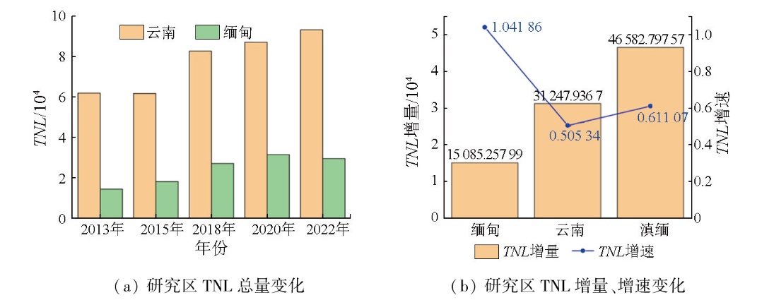
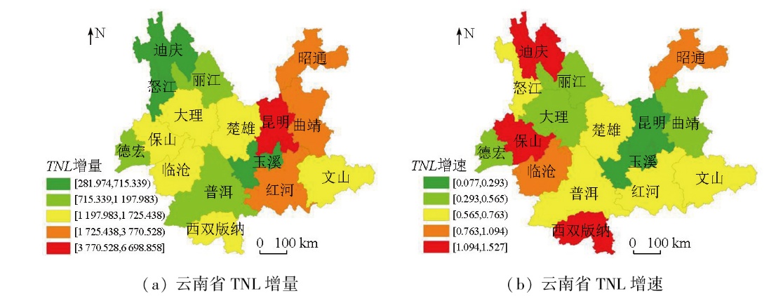
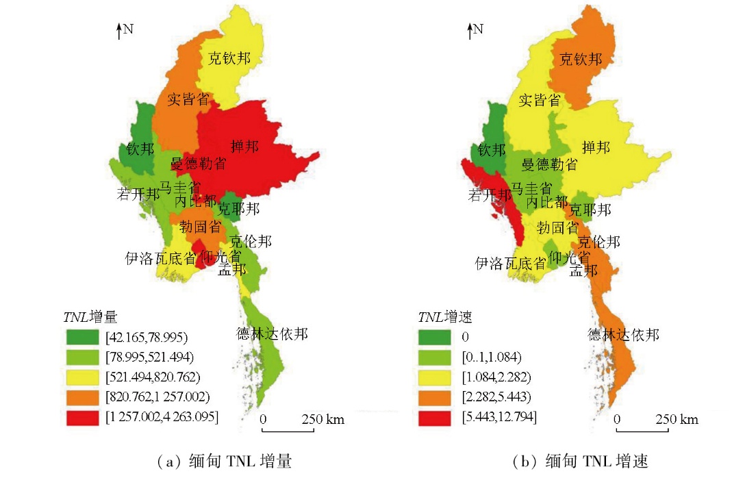
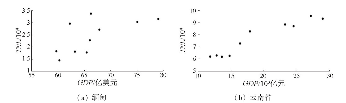
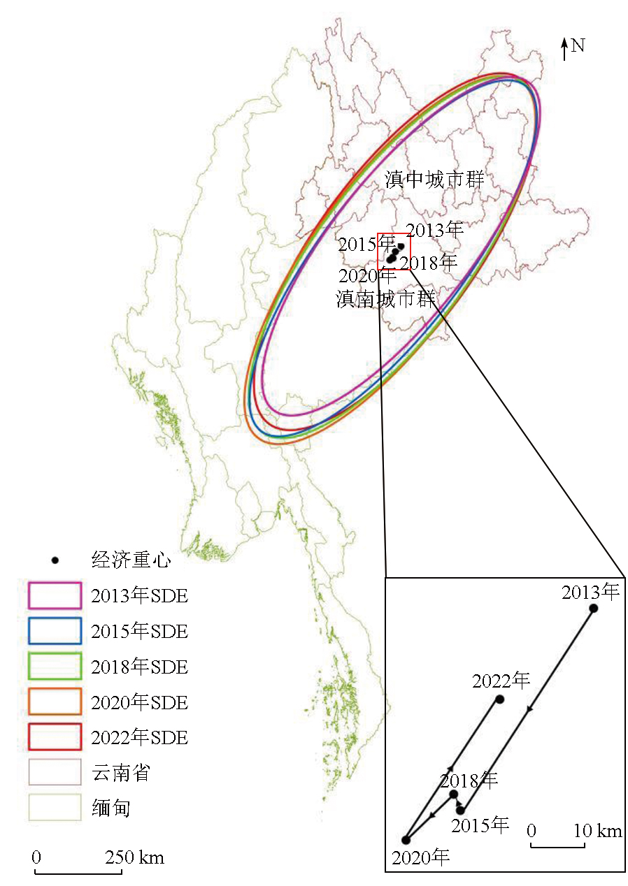
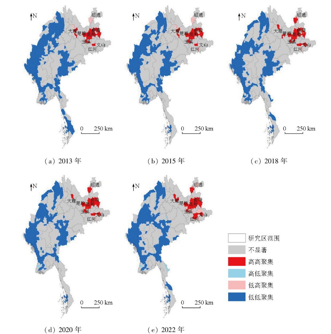
Abstract Investigating the regional economic development of Yunnan Province-a radiation center facing Southeast Asia-and Myanmar-a country along the Belt and Road Initiative-is of great significance for promoting the construction of a China-Myanmar community with a shared future. Based on NPP/VIIRS nighttime light data,as well as spatial analysis methods including the centroid model,standard deviation ellipse,and Moran's I index,this study analyzed the spatiotemporal characteristics of economic development in the Yunnan-Myanmar region from 2013 to 2022. The results indicate a significant correlation between nighttime light and gross domestic product (GDP) data in the Yunnan-Myanmar region. From 2013 to 2022,the total nighttime light intensity in the Yunnan-Myanmar region showed a steadily increasing trend. From the perspective of the characteristics of economic development direction in the region,the economic centroid generally shifted southwestward first and then northeastward. The area of the standard deviation ellipse trended upward from 2013 to 2020 but trended downward in 2022. The long axis of the ellipse showed an increasing trend before 2020 but decreased slightly thereafter,while the short axis showed a stable increasing trend. The azimuth remained largely unchanged. In terms of the spatial correlation of economic development in the region,areas with high nighttime light intensity were primarily concentrated in the central Yunnan urban agglomeration,while those with low nighttime light intensity were mainly distributed in the eastern and western parts of Myanmar. This study can provide a valuable reference for economic and trade exchanges between China and Myanmar,as well as for the implementation of the Belt and Road Initiative.
|
| Keywords
nighttime light remote sensing
Yunnan Province
Myanmar
economic development
spatiotemporal characteristics
|
|
|
|
Issue Date: 28 October 2025
|
|
|
| [1] |
张颖. 中缅命运共同体及其示范意义[J]. 当代世界, 2020(5):60-64.
|
| [1] |
Zhang Y. China-Myanmar community with a shared future and its demonstration significance[J]. Contemporary World, 2020(5):60-64.
|
| [2] |
彭泽军. 云南参与中缅经济走廊建设的现状、困难及建议[J]. 商业经济, 2022(12):75-77.
|
| [2] |
Peng Z J. Present situation,difficulties and suggestions of Yunnan’s participation in the construction of China-Myanmar Economic Corridor[J]. Business & Economy, 2022(12):75-77.
|
| [3] |
闫树熙, 刘志强, 郭利锋. 陕西区域经济发展不平衡水平的定量测度及应对之策[J]. 贵州大学学报(自然科学版), 2020, 37(1):119-124.
|
| [3] |
Yan S X, Liu Z Q, Guo L F. The quantitative measurement of the unbalanced level of regional economic development in Shaanxi Province and the countermeasures[J]. Journal of Guizhou University (Natural Sciences), 2020, 37(1):119-124.
|
| [4] |
苏伟洲, 申洪源. 人口流动对省级区域经济增长的实证检验[J]. 统计与决策, 2017, 33(20):106-110.
|
| [4] |
Su W Z, Shen H Y. Empirical test of population mobility on provincial regional economic growth[J]. Statistics & Decision, 2017, 33(20):106-110.
|
| [5] |
严驰昊, 宁常郁, 赵银军. 中国跨省人口流动对区域经济增长的影响——基于非参数统计方法[J]. 广西科学, 2023, 30(3):587-596.
|
| [5] |
Yan C H, Ning C Y, Zhao Y J. Impacts of inter-provincial population mobility on regional economic growth in China-based on nonparametric statistics method[J]. Guangxi Sciences, 2023, 30(3):587-596.
|
| [6] |
陈颖彪, 郑子豪, 吴志峰, 等. 夜间灯光遥感数据应用综述和展望[J]. 地理科学进展, 2019, 38(2):205-223.
doi: 10.18306/dlkxjz.2019.02.005
|
| [6] |
Chen Y B, Zheng Z H, Wu Z F, et al. Review and prospect of application of nighttime light remote sensing data[J]. Progress in Geography, 2019, 38(2):205-223.
doi: 10.18306/dlkxjz.2019.02.005
|
| [7] |
李德仁, 李熙. 论夜光遥感数据挖掘[J]. 测绘学报, 2015, 44(6):591-601.
doi: 10.11947/j.AGCS.2015.20150149
|
| [7] |
Li D R, Li X. An overview on data mining of nighttime light remote sensing[J]. Acta Geodaetica et Cartographica Sinica, 2015, 44(6):591-601.
doi: 10.11947/j.AGCS.2015.20150149
|
| [8] |
李德仁, 李熙. 夜光遥感技术在评估经济社会发展中的应用——兼论其对“一带一路” 建设质量的保障[J]. 宏观质量研究, 2015, 3(4):1-8.
|
| [8] |
Li D R, Li X. Applications of night-time light remote sensing in evaluating of socioeconomic development[J]. Journal of Macro-Quality Research, 2015, 3(4):1-8.
|
| [9] |
Marx A, Analysis of Panamanian DMSP/OLS nightlights corroborates suspicions of inaccurate fiscal data:A natural experiment examining the accuracy of GDP data[J]. Remote Sensing Applications:Society and Environment, 2017, 8:99-104.
|
| [10] |
Elvidge C D, Baugh K E, Kihn E A, et al. Relation between satellite observed visible-near infrared emissions,population,economic activity and electric power consumption[J]. International Journal of Remote Sensing, 1997, 18(6):1373-1379.
|
| [11] |
王琳, 钟泓文, 许章华, 等. Luojia-01夜光数据和“点轴发育” 理论支持下的夜间经济集聚区定量识别与分类方法[J]. 地球信息科学学报, 2022, 24(11):2141-2152.
doi: 10.12082/dqxxkx.2022.220097
|
| [11] |
Wang L, Zhong H W, Xu Z H, et al. Quantitative identification and classification of the nighttime economic agglomeration based on the Luojia-01 NTL data and pole-axis theory[J]. Journal of Geo-Information Science, 2022, 24(11):2141-2152.
|
| [12] |
李益敏, 傅星峰, 李媛婷, 等. 基于夜光遥感的东南亚国家经济发展时空特征研究[J]. 南京信息工程大学学报, 2024, 16(3):374-385.
|
| [12] |
Li Y M, Fu X F, Li Y T, et al. Spatio-temporal features of economic development in Southeast Asian countries based on nighttime light remote sensing[J]. Journal of Nanjing University of Information Science & Technology, 2024, 16(3):374-385.
|
| [13] |
朱惠, 张清凌, 张珊. 1992—2017年基于夜光遥感的中亚社会经济发展时空特征分析[J]. 地球信息科学学报, 2020, 22(7):1449-1462.
doi: 10.12082/dqxxkx.2020.190808
|
| [13] |
Zhu H, Zhang Q L, Zhang S. Spatial and temporal characteristics of socio-economic development in central Asia based on a series of nighttime light images from 1992 to 2017[J]. Journal of Geo-Information Science, 2020, 22(7):1449-1462.
|
| [14] |
郭永德, 高金环, 马洪兵. Suomi-NPP夜间灯光数据与GDP的空间关系分析[J]. 清华大学学报(自然科学版), 2016, 56(10):1122-1130.
doi: 10.16511/j.cnki.qhdxxb.2016.22.049
|
| [14] |
Guo Y D, Gao J H, Ma H B. Spatial correlation analysis of Suomi-NPP nighttime light data and GDP data[J]. Journal of Tsinghua University (Science and Technology), 2016, 56(10):1122-1130.
|
| [15] |
李林玥, 孙志贤, 龙翔. “一带一路”沿线国家与中国的贸易发展状况研究——夜间灯光数据在引力模型中的实证分析[J]. 数量经济技术经济研究, 2018, 35(3):39-58.
|
| [15] |
Li L Y, Sun Z X, Long X. The study of trade development between “the Belt and Road Initiative” countries along the line and China[J]. Journal of Quantitative & Technological Economics, 2018, 35(3):39-58.
|
| [16] |
Doll C H, Muller J P, Elvidge C D. Night-time imagery as a tool for global mapping of socioeconomic parameters and greenhouse gas emissions[J]. AMBIO:A Journal of the Human Environment, 2000, 29(3):157.
|
| [17] |
李建忠, 郑著彬, 张润飞, 等. 赣南与闽西地区经济空间格局的夜光遥感研究——以原赣南、闽西苏区为例[J]. 赣南师范大学学报, 2020, 41(3):83-90.
|
| [17] |
Li J Z, Zheng Z B, Zhang R F, et al. Remote observation of economic spatial pattern for Gannan and Minxi based on NPP/VIIRS nighttime imagery:A case study of the former soviet areas in southern Jiangxi and western Fujian[J]. Journal of Gannan Normal University, 2020, 41(3):83-90.
|
| [18] |
陈琛, 马毅, 江涛. 基于DMSP/OLS夜光遥感的山东半岛城市经济参量时空模拟分析[J]. 海洋技术学报, 2020, 39(1):10-18.
|
| [18] |
Chen C, Ma Y, Jiang T. Spatial and temporal simulation analysis of urban economic parameters of the Shandong Peninsula based on DMSP/OLS night-time light remote sensing[J]. Journal of Ocean Technology, 2020, 39(1):10-18.
|
| [19] |
罗虹, 赵政权. 基于NPP-VIIRS的云南省城市经济空间格局演变[J]. 地理空间信息, 2022, 20(1):32-37,7.
|
| [19] |
Luo H, Zhao Z Q. Urban economic spatial pattern evolution of Yunnan Province based on NPP-VIIRS[J]. Geospatial Information, 2022, 20(1):32-37,7.
|
| [20] |
肖卫东. 中国种植业地理集聚的空间统计分析[J]. 经济地理, 2014, 34(9):124-129.
|
| [20] |
Xiao W D. Spatial statistics analysis of China’s planting geographic agglomeration[J]. Economic Geography, 2014, 34(9):124-129.
|
| [21] |
王勤. 东南亚最不发达四国经济发展进程与前景[J]. 南亚东南亚研究, 2023(1):105-115,156.
|
| [21] |
Wang Q. The economic development process and prospects of the four least developed countries in Southeast Asia[J]. South and Southeast Asian Studies, 2023(1):105-115,156.
|
| [22] |
李晨阳, 孟姿君, 罗圣荣. “一带一路”框架下的中缅经济走廊建设:主要内容、面临挑战与推进路径[J]. 南亚研究, 2019,(04):112-133+157-158.
|
| [22] |
Li C Y, Meng Z J, Luo S R. The construction of the China-Myanmar Economic Corridor under the Belt and Road Initiative:Core contents,challenges and paths forward.[J]. South Asian Studies, 2019(4):112-133,157-158.
|
| [23] |
李逸, 赵媛, 夏四友. 中国跨境油气运输管道安全性评价与类型区划分[J]. 自然资源学报, 2024, 39(3):547-563.
doi: 10.31497/zrzyxb.20240304
|
| [23] |
Li Y, Zhao Y, Xia S Y. Safety evaluation and classification of cross-border oil and gas transportation pipelines in China[J]. Journal of Natural Resources, 2024, 39(3):547-563.
doi: 10.31497/zrzyxb.20240304
|
|
Viewed |
|
|
|
Full text
|
|
|
|
|
Abstract
|
|
|
|
|
Cited |
|
|
|
|
| |
Shared |
|
|
|
|
| |
Discussed |
|
|
|
|
 2025,
Vol. 37
2025,
Vol. 37
 ), LI Yimin2,3(