|
|
|
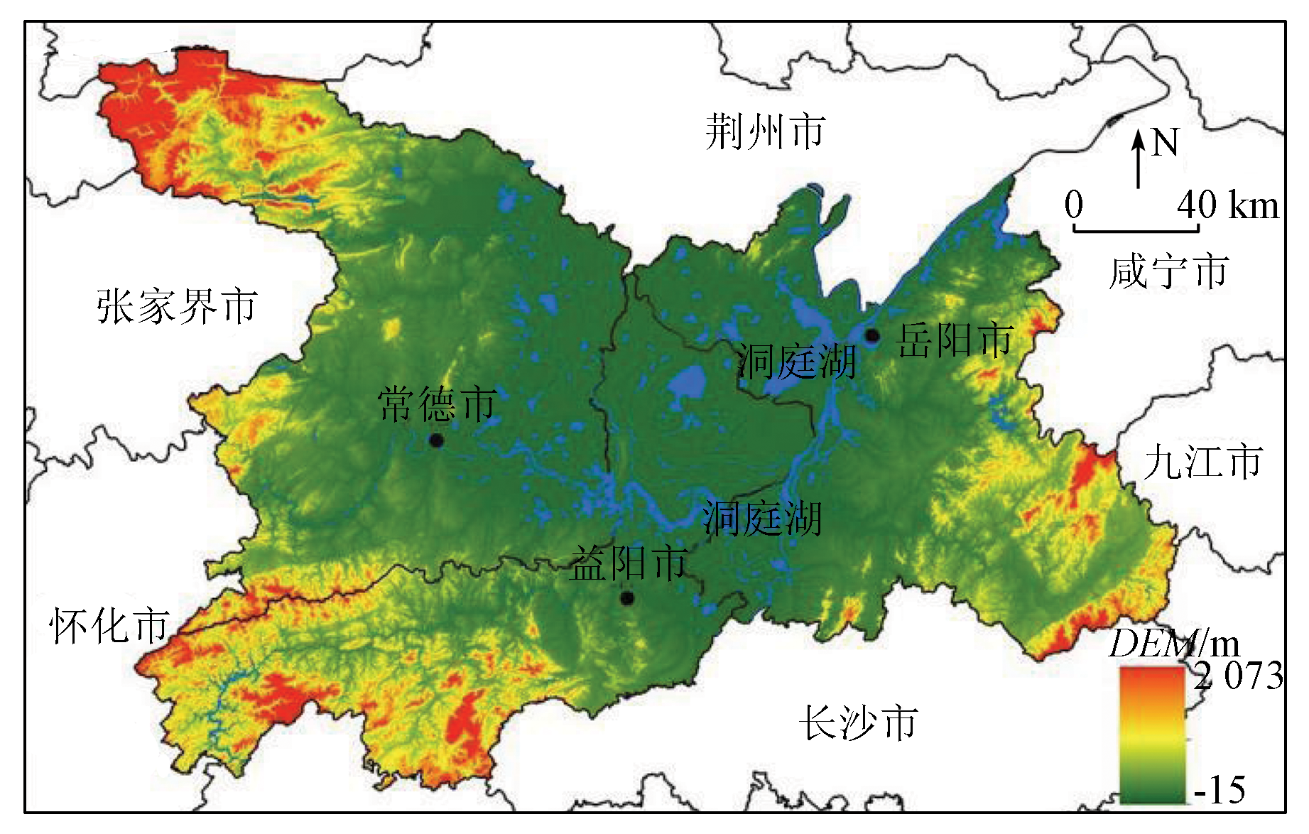
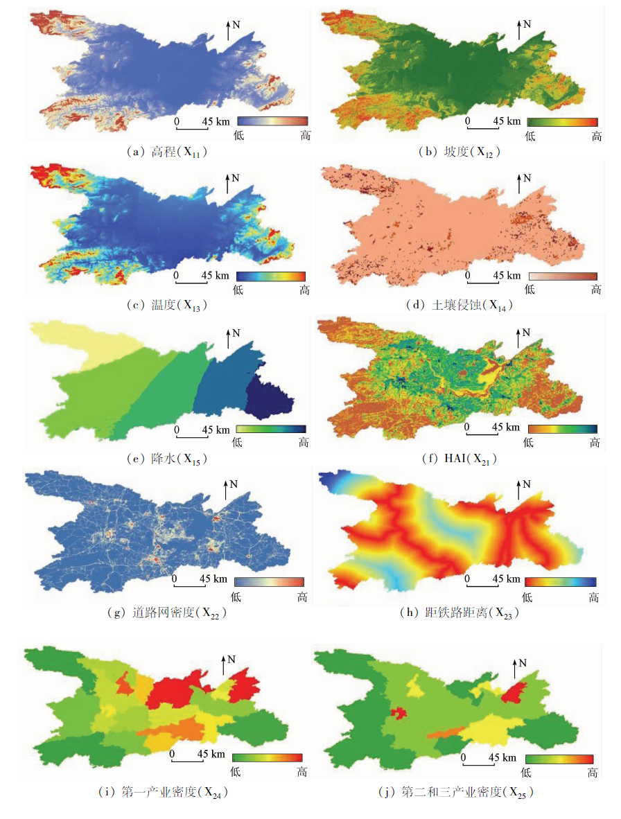
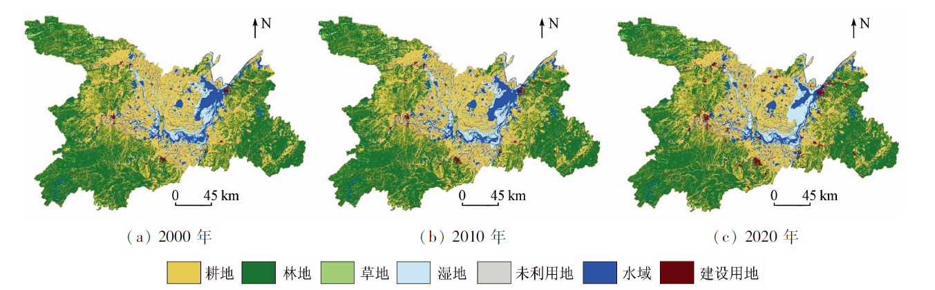
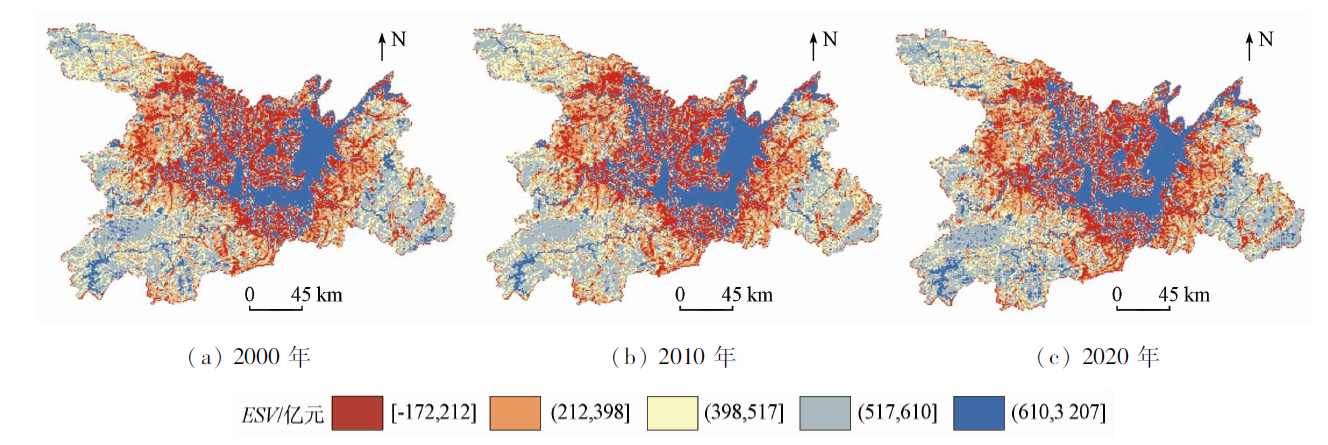
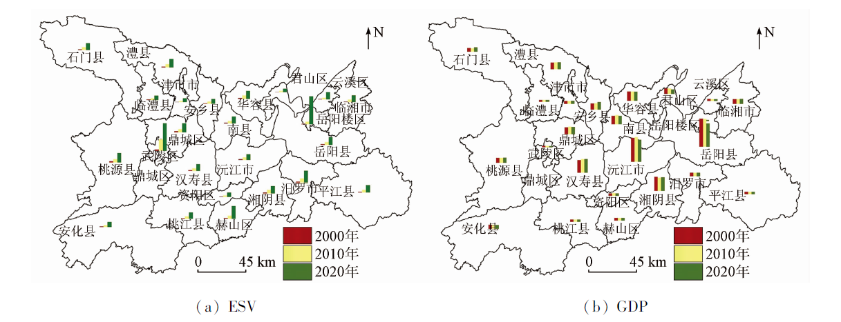
Abstract Economic development is frequently accompanied by the decreased quality and dysfunctional service capacity of the ecological environment. Clarifying the relationship and spatial differences between ecology and economy is a prerequisite for sustainable regional development. Based on the remote sensing images and socio-economic data of the Dongting Lake area in 2000, 2010, and 2020, this study calculated the ecosystem service values using the value equivalent method. Furthermore, it determined the coordination and consistency indices of ecosystem services and economy in 24 districts and counties in the Dongting Lake area. Then, this study comprehensively explored the relationship between ecological services and the economy, as well as their spatial aggregation, proposing targeted optimization measures for coordinating and balancing regional ecological services and economic development. The results are as follows: ① The total ecosystem service value of the Dongting Lake area decreased from 261.541 billion yuan in 2000 to 255.646 billion yuan in 2020. The spatial distribution of ecosystem service values presented a circular layer pattern, with high values occurring in the center, followed by the peripheral mountains, while the lowest values present in adjacent hills and plains. ② As for individual ecological service values, hydrological regulation contributed the most significantly, while the nutrient cycle maintenance contributed slightly. Additionally, the values of ecological services, except for biodiversity and aesthetic landscape, decreased to varying degrees during the study period. Among them, the hydrological regulation presented the most significant reduction in the ecological service values, accounting for more than 70% of the total reduction. ③ Regarding the spatio-temporal variations in the ecological services and economic development, the Dongting Lake area showed relatively stable ecological differences and expanded economic gaps. Districts and counties in the Dongting Lake area showed high coordination degrees but low consistency levels between ecology and economy. The ecological and economic spatial aggregations exhibited significant differences, with dominant ecological aggregation zones mainly distributed within and along Dongting Lake. ④ The critical driving factors in the spatial differences in ecological service values include human disturbance, elevation, slope, temperature, and precipitation. Therefore, to promote the harmonious development of ecology and economy in the Dongting Lake area and weaken the gap between both, it is necessary to propose feasible measures for strictly protecting the natural basement, strengthening human-guided utilization, and promoting the transformation from ecological resources into economic products.
|
| Keywords
land use
ecological service value
economic development
coupled coordinate
Dongting Lake area
|
|
|
|
Issue Date: 19 September 2023
|
|
|
| [1] |
马立新, 覃雪波, 孙楠, 等. 大小兴安岭生态资产变化格局[J]. 生态学报, 2013, 33(24):7838-7845.
|
| [1] |
Ma L X, Qin X B, Sun N, et al. The pattern of ecological capital in Daxiaoxinganling,Heilongjiang Province,China[J]. Acta Ecologica Sinica, 2013, 33(24):7838-7845.
|
| [2] |
Abernethy V D. Nature’s services:Societal dependence on natural ecosystems[J]. Population and Environment, 1999, 20(3):277-278.
doi: 10.1023/A:1023307309124
url: http://link.springer.com/10.1023/A:1023307309124
|
| [3] |
Termorshuizen J W, Opdam P. Landscape services as a bridge between landscape ecology and sustainable development[J]. Landscape Ecology, 2009, 24(8):1037-1052.
doi: 10.1007/s10980-008-9314-8
url: http://link.springer.com/10.1007/s10980-008-9314-8
|
| [4] |
郑茜. 武汉市生态空间评价与优化研究[D]. 武汉: 华中师范大学, 2018.
|
| [4] |
Zheng X. A Study on optimization and spatial estimate of ecological space in Wuhan City[D]. Wuhan: Central China Normal University, 2018.
|
| [5] |
高雪玲. 秦岭山地植被生态系统服务功能及其空间特征研究[D]. 西安: 西北大学, 2004.
|
| [5] |
Gao X L. Study on the service function and spatial characteristics of vegetation ecosystem in Qinling Mountains[D]. Xi’an: Northwest University, 2004.
|
| [6] |
秦晓川, 付碧宏. 青岛都市圈生态系统服务-经济发展时空协调性分析及优化利用[J]. 生态学报, 2020, 40(22):8251-8264.
|
| [6] |
Qin X C, Fu B H. Spatio-temporal coordination between ecosystem services and economic development and its optimal utilization in Qingdao Metropolitan Region,China[J]. Acta Ecologica Sinica, 2020, 40(22):8251-8264.
|
| [7] |
Costanza R, D’arge R, De Groot R, et al. The value of the world’s ecosystem services and natural capital[J]. Ecological Economics, 1998, 25(1):3-15.
doi: 10.1016/S0921-8009(98)00020-2
url: https://linkinghub.elsevier.com/retrieve/pii/S0921800998000202
|
| [8] |
谢高地, 鲁春霞, 冷允法, 等. 青藏高原生态资产的价值评估[J]. 自然资源学报, 2003(2):189-196.
|
| [8] |
Xie G D, Lu C X, Leng Y F, et al. Ecological assets valuation of the Tibetan Plateau[J]. Journal of Natural Resources, 2003(2):189-196.
doi: 10.11849/zrzyxb.2003.02.010
|
| [9] |
谢高地, 肖玉, 甄霖, 等. 我国粮食生产的生态服务价值研究[J]. 中国生态农业学报, 2005(3):10-13.
|
| [9] |
Xie G D, Xiao Y, Zhen L, et al. Study on ecosystem services value of food production in China[J]. Chinese Journal of Eco-Agriculture, 2005(3):10-13.
|
| [10] |
谢高地, 张彩霞, 张雷明, 等. 基于单位面积价值当量因子的生态系统服务价值化方法改进[J]. 自然资源学报, 2015, 30(8):1243-1254.
|
| [10] |
Xie G D, Zhang C X, Zhang L M, et al. Improvement of ecosystem service value method based on unit area value equivalent factor[J]. Journal of Natural Resource, 2015, 30(8):1243-1254.
|
| [11] |
赵景柱, 徐亚骏, 肖寒, 等. 基于可持续发展综合国力的生态系统服务评价研究——13个国家生态系统服务价值的测算[J]. 系统工程理论与实践, 2003(1):121-127.
doi: 10.12011/1000-6788(2003)1-121
|
| [11] |
Zhao J Z, Xu Y J, Xiao H, et al. Ecosystem services evaluation based on comprehensive national power for sustainable development:The evaluations on 13 countries[J]. Systems Engineering-Theory and Practice, 2003(1):121-127.
|
| [12] |
吴建寨, 李波, 张新时. 生态系统服务价值变化在生态经济协调发展评价中的应用[J]. 应用生态学报, 2007(11):2554-2558.
|
| [12] |
Wu J Z, Li B, Zhang X S. Ecosystem service its application in evaluation of eco-economic harmonious development[J]. Acta Ecologica Sinica, 2007(11):2554-2558.
|
| [13] |
Wang J H, Tian J H, Li X Y, et al. Evaluation of concordance between environment and economy in Qinghai Lake watershed,Qinghai Tibet Plateau[J]. Journal of Geographical Sciences, 2011, 21(5):949-960.
doi: 10.1007/s11442-011-0892-z
url: http://link.springer.com/10.1007/s11442-011-0892-z
|
| [14] |
陈端吕, 陈哲夫, 彭保发. 土地利用生态服务价值与经济发展的协调及空间分异——以西洞庭湖区为例[J]. 地理研究, 2018, 37(9):1692-1703.
doi: 10.11821/dlyj201809003
|
| [14] |
Chen D L, Chen Z F, Peng B F. Spatial differentiation and coupling effect between land ecosystem services value and economic develo-pment:A case study of west Dongting Lake area[J]. Geographical Research, 2018, 37(9):1692-1703.
|
| [15] |
Li T H, Ding Y. Spatial disparity dynamics of ecosystem service values and GDP in Shaanxi Province,China in the last 30 years[J]. PLoS One, 2017, 12(3):e0174562.
doi: 10.1371/journal.pone.0174562
url: https://dx.plos.org/10.1371/journal.pone.0174562
|
| [16] |
阳华, 王兆林, 孙思睿, 等. 三峡库区生态系统服务价值与经济重心演变的耦合分析[J]. 水土保持研究, 2021, 28(6):242-250.
|
| [16] |
Yang H, Wang Z L, Sun S R, et al. Coupling analysis of ecosystem service value and economic gravity evolution in the Three Gorges Reservoir area[J]. Research of Soil and Water Conservation, 2021, 28(6):242-250.
|
| [17] |
熊建新, 陈端吕, 彭保发, 等. 洞庭湖区生态承载力系统耦合协调度时空分异[J]. 地理科学, 2014, 34(9):1108-1116.
doi: 10.13249/j.cnki.sgs.2014.09.1108
|
| [17] |
Xiong J X, Chen D L, Peng B F, et al. Spatio-temporal difference of coupling coordinative degree of ecological carrying capacity in the Dongting Lake region[J]. Scientia Geographica Sinica, 2014, 34(9):1108-1116.
|
| [18] |
陈端吕, 陈哲夫, 彭保发, 等. 洞庭湖区资源环境研究[M]. 南京: 南京大学出版社, 2019:214.
|
| [18] |
Chen D L, Chen Z F, Peng B F, et al. Study on the resources and environment of the Dongting Lake region[M]. Nanjing: Nanjing University Press, 2019:214.
|
| [19] |
段瑞娟, 郝晋珉, 张洁瑕. 北京区位土地利用与生态服务价值变化研究[J]. 农业工程学报, 2006(9):21-28.
|
| [19] |
Duan R J, Hao J M, Zhang J X. Land utilization and changes on eco-service value in different locations in Beijing[J]. Transactions of the CSAE, 2006(9):21-28.
|
| [20] |
杨倩. 湖北汉江流域土地利用时空演变与生态安全研究[D]. 武汉: 武汉大学, 2017.
|
| [20] |
Yang Q. The study of land use spatio-temporal transformation and ecological security in the Hanjiang River basin of Hubei[D]. Wuhan: Wuhan University, 2017.
|
| [21] |
张建设, 王刚. 植物生物量研究综述[J]. 四川林业科技, 2014, 35(1):44-48.
|
| [21] |
Zhang J S, Wang G. A review of researches on plant biomass[J]. Journal of Sichuan Forestry Science and Technology, 2014, 35(1):44-48.
|
| [22] |
潘耀忠, 史培军, 朱文泉, 等. 中国陆地生态系统生态资产遥感定量测量[J]. 中国科学(D辑:地球科学), 2004(4):375-384.
|
| [22] |
Pan Y Z, Shi P J, Zhu W Q, et al. Remote sensing quantitative measurement of ecological assets of terrestrial ecosystem in China[J]. Science China, 2004(4):375-384.
|
| [23] |
陈浮, 葛小平, 陈刚, 等. 城市边缘区景观变化与人为影响的空间分异研究[J]. 地理科学, 2001(3):210-216.
|
| [23] |
Chen F, Ge X P, Chen G, et al. Spatial different analysis of landscape change and human impact in urban fringe[J]. Scientia Geographica Sinica, 2001(3):210-216.
doi: 10.13249/j.cnki.sgs.2001.03.210
|
| [24] |
严恩萍, 林辉, 王广兴, 等. 1990—2011年三峡库区生态系统服务价值演变及驱动力[J]. 生态学报, 2014, 34(20):5962-5973.
|
| [24] |
Yan E P, Lin H, Wang G X, et al. Analysis of evolution and driving force of ecosystem service values in the Three Gorges Reservoir region during 1990—2011[J]. Acta Ecologica Sinica, 2014, 34(20):5962-5973.
|
| [25] |
王劲峰, 徐成东. 地理探测器:原理与展望[J]. 地理学报, 2017, 72(1):116-134.
doi: 10.11821/dlxb201701010
|
| [25] |
Wang J F, Xu C D. Geodetector:Principle and prospective[J]. Acta Geographica Sinica, 2017, 72(1):116-134.
|
| [26] |
Wang J F, Li X H, Christakos G, et al. Geographical detectors-based health risk assessment and its application in the neural tube defects study of the Heshun Region,China[J]. International Journal of Geographical Information Science, 2010, 24(1):107-127.
doi: 10.1080/13658810802443457
url: http://www.tandfonline.com/doi/abs/10.1080/13658810802443457
|
| [27] |
黄木易, 方斌, 岳文泽, 等. 近20 a来巢湖流域生态服务价值空间分异机制的地理探测[J]. 地理研究, 2019, 38(11):2790-2803.
doi: 10.11821/dlyj020181075
|
| [27] |
Huang M Y, Fang B, Yue W Z, et al. Spatial differentiation of ecosystem service values and its geographical detection in Chaohu Basin during 1995—2017[J]. Geographical Research, 2019, 38(11):2790-2803.
|
| [28] |
程俊翔, 徐力刚, 王青, 等. 洞庭湖近30 a水位时空演变特征及驱动因素分析[J]. 湖泊科学, 2017, 29(4):974-983.
|
| [28] |
Cheng J X, Xu L G, Wang Q, et al. Temporal and spatial variations of water level and its driving forces in Lake Dongting over the last three decades[J]. Journal of Lake Sciences, 2017, 29(4):974-983.
doi: 10.18307/2017.0421
url: http://www.jlakes.org/ch/reader/view_abstract.aspx?doi=10.18307/2017.0421
|
| [29] |
朱文泉, 张锦水, 潘耀忠, 等. 中国陆地生态系统生态资产测量及其动态变化分析[J]. 应用生态学报, 2007(3):586-594.
|
| [29] |
Zhu W Q, Zhang J S, Pan Y Z, et al. Measurement and dynamic analysis of ecological capital of terrestrial ecosystem in China[J]. Chinese Journal of Applied Ecology, 2007(3):586-594.
|
| [30] |
张鹏岩, 耿文亮, 杨丹, 等. 黄河下游地区土地利用和生态系统服务价值的时空演变[J]. 农业工程学报, 2020, 36(11):277-288.
|
| [30] |
Zhang P Y, Geng W L, Yang D, et al. Spatial-temporal evolution of land use and ecosystem service value in the lower reaches of the Yellow River region[J]. Transactions of the CSAE, 2020, 36(11):277-288.
|
| [31] |
柴茂. 洞庭湖区生态的政府治理机制建设研究[D]. 湘潭: 湘潭大学, 2016.
|
| [31] |
Chai M. Research on the building of government management mechanism for the Dongting Lake area’s ecology[D]. Xiangtan: Xiangtan University, 2016.
|
| [32] |
魏伟, 石培基, 魏晓旭, 等. 中国陆地经济与生态环境协调发展的空间演变[J]. 生态学报, 2018, 38(8):2636-2648.
|
| [32] |
Wei W, Shi P J, Wei X X, et al. Evaluation of the coordinated development of economy and eco-environmental systems and spatial evolution in China[J]. Acta Ecologica Sinica, 2018, 38(8):2636-2648.
|
| [33] |
李真, 潘竟虎, 胡艳兴. 甘肃省生态资产价值和生态-经济协调度时空变化格局[J]. 自然资源学报, 2017, 32(1):64-75.
doi: 10.11849/zrzyxb.20160181
|
| [33] |
Li Z, Pan J H, Hu Y X. The Spatio-temporal variation of ecological property value and eco-economic harmony in Gansu Province[J]. Journal of Natural Resources, 2017, 32(1):64-75.
doi: 10.11849/zrzyxb.20160181
|
| [34] |
韩增林, 赵玉青, 闫晓露, 等. 生态系统生产总值与区域经济耦合协调机制及协同发展——以大连市为例[J]. 经济地理, 2020, 40(10):1-10.
|
| [34] |
Han Z L, Zhao Y Q, Yan X L, et al. Coupling coordination mechanism and spatial-temporal relationship between gross ecosystem product and regional economy: A case study of Dalian[J]. Economic Geography, 2020, 40(10):1-10.
doi: 10.2307/142170
url: https://www.jstor.org/stable/142170?origin=crossref
|
| [35] |
邓楚雄, 钟小龙, 谢炳庚, 等. 洞庭湖区土地生态系统的服务价值时空变化[J]. 地理研究, 2019, 38(4):844-855.
doi: 10.11821/dlyj020170999
|
| [35] |
Deng C X, Zhong X L, Xie B G, et al. Spatial and temporal changes of land ecosystem service value in Dongting Lake area in 1995—2015[J]. Geographical Research, 2019, 38(4):844-855.
|
|
Viewed |
|
|
|
Full text
|
|
|
|
|
Abstract
|
|
|
|
|
Cited |
|
|
|
|
| |
Shared |
|
|
|
|
| |
Discussed |
|
|
|
|
 2023,
Vol. 35
2023,
Vol. 35
 ), YANG Fan(