|
|
 |
|

|
|
|
Exploring the spatio-temporal variations and influencing factors of vegetation cover in Yunnan Province |
LI Yimin1,2( ), FENG Xianjie3, LI Yuanting3, YANG Xue1, XIANG Qianying3, JI Peikun1 ), FENG Xianjie3, LI Yuanting3, YANG Xue1, XIANG Qianying3, JI Peikun1 |
1. School of Earth Sciences, Yunnan University, Kunming 650500, China
2. Research Center of Domestic High-resolutellite Remote Sensing Geological Engineering, Kunming 650500, China
3. Institute of International Rivers and Eco-Security, Yunnan University, Kunming 650500, China |
|
|
|
|
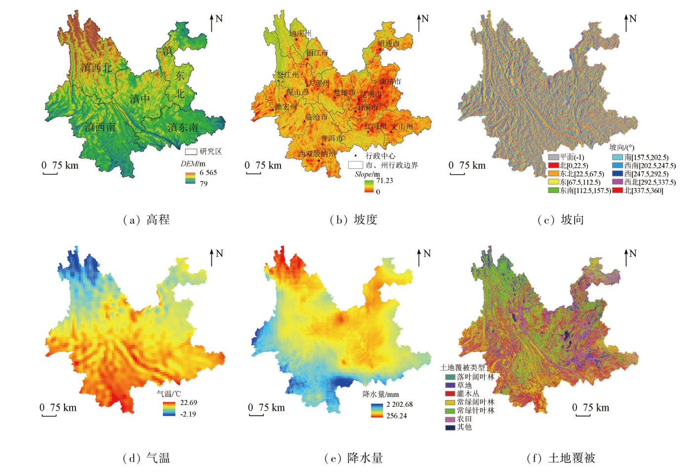
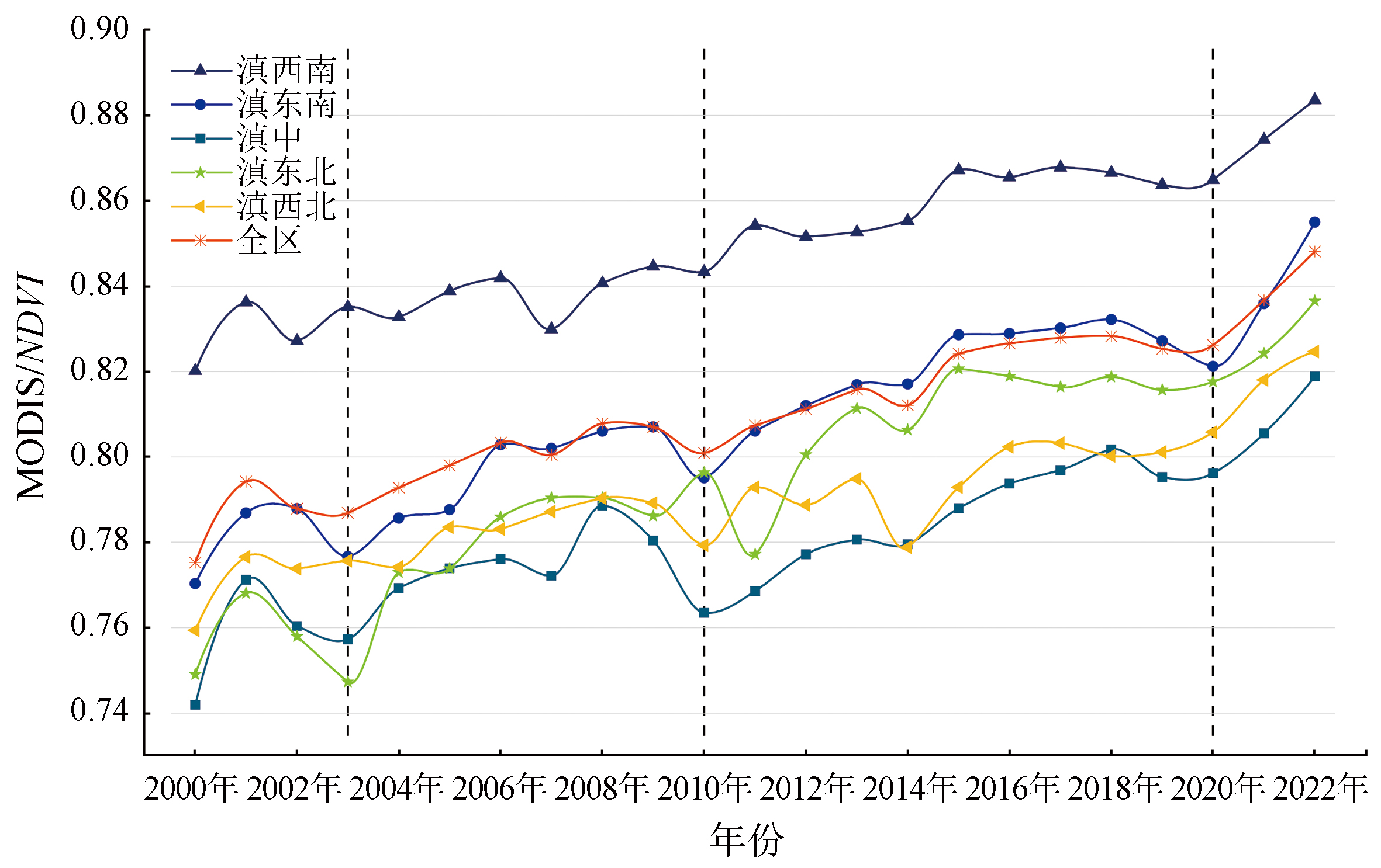
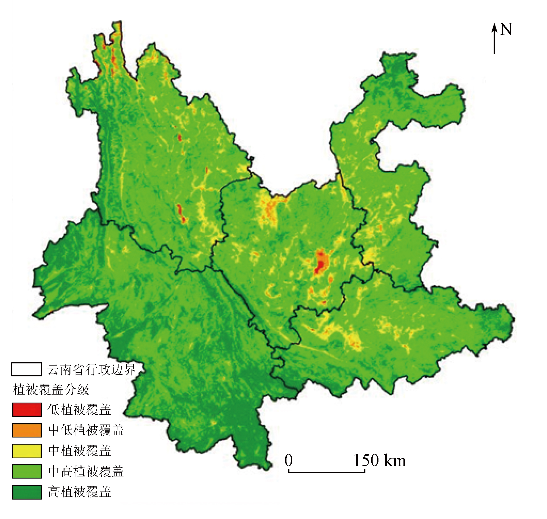
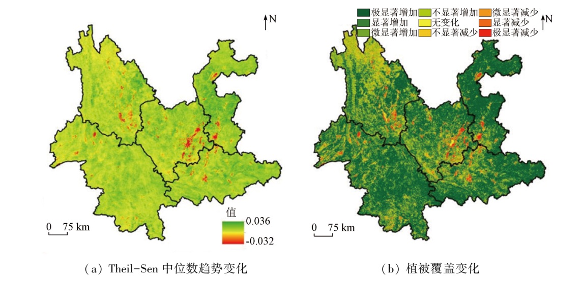
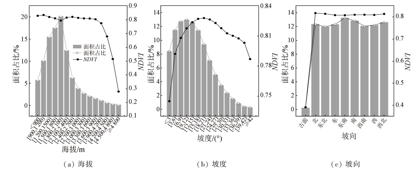
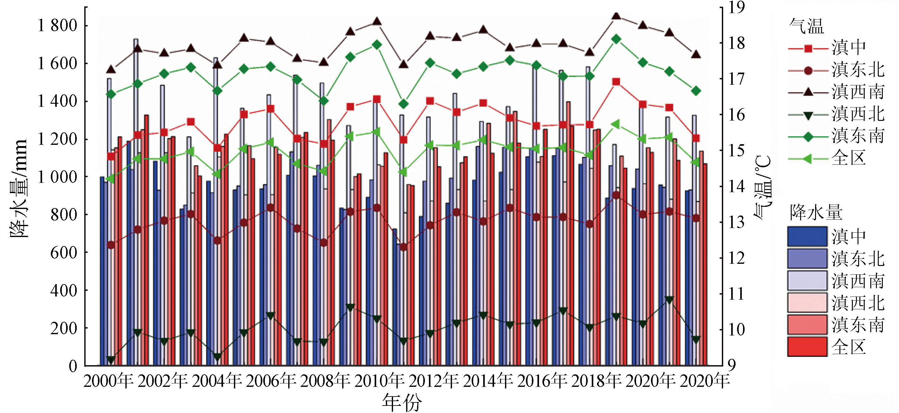
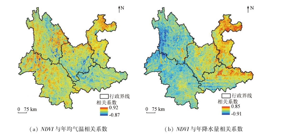
Abstract Yunnan Province has abundant species resources but fragile ecosystems, and the ecological vulnerability is closely related to vegetation cover. Hence, based on the normalized difference vegetation index (NDVI) from the MOD13Q1 dataset for 2000—2022, this study dynamically monitored the spatio-temporal variations of vegetation using the maximum value composite (MVC), Theil-Sen median trend analysis, and Mann-Kendall significance test. Moreover, this study delved into the response of vegetation to factors like topography, climate change, and land cover through correlation analysis. The results show that: ① From 2000 to 2022, the overall vegetation coverage of Yunnan Province was relatively high, with average annual NDVI values ranging from 0.74 to 0.90, showing a fluctuating upward trend. Of the whole area, 91.17% exhibited an increasing vegetation coverage trend, with the fastest growth rate seen in northeastern Yunnan; ② Regional differences were observed in vegetation cover, which was higher in southeastern and southwestern Yunnan compared to northwestern, central, and northeastern Yunnan; ③ The NDVI values of Yunnan Province were relatively stable below the altitude of 3 900 m, and decreased with increasing altitude in the case of over 3 900 m; ④ The NDVI values were the lowest with slopes below 3°, and with an increase in slope, they increased first and then decreased; ⑤ The planar slope aspect displayed the lowest NDVI values, and other slope aspects showed minimal impact on vegetation growth; ⑥ From 2000 to 2022, the vegetation cover in central, southeastern, and northeastern Yunnan was positively correlated with precipitation, suggesting that precipitation in these areas was favorable for vegetation growth. However, the vegetation cover in southwestern and northwestern Yunnan showed a negative correlation with precipitation. Additionally, the vegetation cover in the whole region and various areas was positively correlated with temperature, suggesting that temperature is beneficial to vegetation growth. The results of this study will provide a scientific basis for strengthening ecological environment construction and ecological management in Yunnan Province.
|
| Keywords
MODIS NDVI
vegetation change
Theil-Sen trend
Mann-Kendall test
correlation
Yunnan Province
|
|
|
|
Issue Date: 14 June 2024
|
|
|
| [1] |
Li J J, Peng S Z, Li Z. Detecting and attributing vegetation changes on China’s Loess Plateau[J]. Agricultural and Forest Meteorology, 2017, 247:260-270.
|
| [2] |
杨艳萍, 陈建军, 覃巧婷, 等. 2000—2018年广西植被时空变化及其对地形、气候和土地利用的响应[J]. 农业工程学报, 2021, 37(17):234-241.
|
| [2] |
Yang Y P, Chen J J, Qin Q T, et al. Temporal and spatial variation of vegetation and its response to topography,climate and land use in Guangxi during 2000—2018[J]. Transactions of the Chinese Society of Agricultural Engineering, 2021, 37(17):234-241.
|
| [3] |
苗百岭, 梁存柱, 韩芳, 等. 内蒙古主要草原类型植物物候对气候波动的响应[J]. 生态学报, 2016, 36(23):7689-7701.
|
| [3] |
Miao B L, Liang C Z, Han F, et al. Responses of phenology to climate change over the major grassland types[J]. Acta Ecologica Sinica, 2016, 36(23):7689-7701.
|
| [4] |
路洁, 王学凤, 曹永强. 气候和人类活动对辽宁省植被变化的影响[J]. 水利水电科技进展, 2022, 42(4):7-14,38.
|
| [4] |
Lu J, Wang X F, Cao Y Q. Effects of climate and human activities on vegetation change in Liaoning Province[J]. Advances in Science and Technology of Water Resources, 2022, 42(4):7-14,38.
|
| [5] |
金凯, 王飞, 韩剑桥, 等. 1982—2015年中国气候变化和人类活动对植被NDVI变化的影响[J]. 地理学报, 2020, 75(5):961-974.
doi: 10.11821/dlxb202005006
|
| [5] |
Jin K, Wang F, Han J Q, et al. Contribution of climatic change and human activities to vegetation NDVI change over China during 1982-2015[J]. Acta Geographica Sinica, 2020, 75(5):961-974.
doi: 10.11821/dlxb202005006
|
| [6] |
逯金鑫, 周荣磊, 刘洋洋, 等. 黄土高原植被覆被时空动态及其影响因素[J]. 水土保持研究, 2023, 30(2):211-219.
|
| [6] |
Lu J X, Zhou R L, Liu Y Y, et al. Temporal and spatial dynamics of vegetation cover on the Loess Plateau and its influencing factors[J]. Research of Soil and Water Conservation, 2023, 30(2):211-219.
|
| [7] |
武锦辉. 基于多源遥感数据的物种多样性及陆表植被恢复力监测研究[J]. 测绘学报, 2022, 51(8):1826.
doi: 10.11947/j.AGCS.2022.20200539
|
| [7] |
Wu J H. Monitoring species diversity and measuring vegetation resilience with satellite remote sensing[J]. Acta Geodaetica et Cartographica Sinica, 2022, 51(8):1826.
doi: 10.11947/j.AGCS.2022.20200539
|
| [8] |
郑朝菊, 曾源, 赵玉金, 等. 近15年中国西南地区植被覆盖度动态变化[J]. 国土资源遥感, 2017, 29(3):128-136.doi:10.6046/gtzyyg.2017.03.19.
|
| [8] |
Zheng Z J, Zeng Y, Zhao Y J, et al. Monitoring and dynamic analysis of fractional vegetation cover in southwestern China over the past 15 years based on MODIS data[J]. Remote Sensing for Land and Resources, 2017, 29(3):128-136.doi:10.6046/gtzyyg.2017.03.19.
|
| [9] |
熊俊楠, 彭超, 程维明, 等. 基于MODIS-NDVI的云南省植被覆盖度变化分析[J]. 地球信息科学学报, 2018, 20(12):1830-1840.
doi: 10.12082/dqxxkx.2018.180371
|
| [9] |
Xiong J N, Peng C, Cheng W M, et al. Analysis of vegetation coverage change in Yunnan Province based on MODIS-NDVI[J]. Journal of Geo-Information Science, 2018, 20(12):1830-1840.
|
| [10] |
赵安周, 刘宪锋, 朱秀芳, 等. 2000—2014年黄土高原植被覆盖时空变化特征及其归因[J]. 中国环境科学, 2016, 36(5):1568-1578.
|
| [10] |
Zhao A Z, Liu X F, Zhu X F, et al. Spatiotemporal analyses and associated driving forces of vegetation coverage change in the Loess Plateau[J]. China Environmental Science, 2016, 36(5):1568-1578.
|
| [11] |
刘哲, 邱炳文, 王壮壮, 等. 2001—2014年间黄土高原植被覆盖状态时空演变分析[J]. 国土资源遥感, 2017, 29(1):192-198.doi:10.6046/gtzyyg.2017.01.29.
|
| [11] |
Liu Z, Qiu B W, Wang Z Z, et al. Temporal and spatial variation analysis of vegetation cover in the Loess Plateau from 2001 to 2014[J]. Remote Sensing for Land and Resources, 2017, 29(1):192-198.doi:10.6046/gtzyyg.2017.01.29.
|
| [12] |
Li S S, Yang S N, Liu X F, et al. NDVI-Based analysis on the influence of climate change and human activities on vegetation restoration in the Shaanxi-Gansu-Ningxia region,Central China[J]. Remote Sensing, 2015, 7(9):11163-11182.
|
| [13] |
Pang G J, Wang X J, Yang M X. Using the NDVI to identify variations in,and responses of,vegetation to climate change on the Tibetan Plateau from 1982 to 2012[J]. Quaternary International, 2017, 444:87-96.
|
| [14] |
Chu H S, Venevsky S, Wu C, et al. NDVI-based vegetation dynamics and its response to climate changes at Amur-Heilongjiang River Basin from 1982 to 2015[J]. The Science of the Total Environment, 2019, 650(Pt 2):2051-2062.
doi: S0048-9697(18)33557-5
pmid: 30290347
|
| [15] |
Zoungrana B J, Conrad C, Thiel M, et al. MODIS NDVI trends and fractional land cover change for improved assessments of vegetation degradation in Burkina Faso,West Africa[J]. Journal of Arid Environments, 2018, 153:66-75.
|
| [16] |
杨红娟, 张成浩. 基于系统动力学的云南生态文明建设有效路径研究[J]. 中国人口·资源与环境, 2019, 29(2):16-24.
|
| [16] |
Yang H J, Zhang C H. Research on the effective route of ecological civilization construction in Yunnan Province based on System Dynamics[J]. China Population,Resources and Environment, 2019, 29(2):16-24.
|
| [17] |
阮宏威, 于静洁. 1992—2015年中亚五国土地覆盖与蒸散发变化[J]. 地理学报, 2019, 74(7):1292-1304.
doi: 10.11821/dlxb201907002
|
| [17] |
Ruan H W, Yu J J. Changes in land cover and evapotranspiration in the five Central Asian countries from 1992 to 2015[J]. Acta Geographica Sinica, 2019, 74(7):1292-1304.
doi: 10.11821/dlxb201907002
|
| [18] |
Yang Y J, Wang S J, Bai X Y, et al. Factors affecting long-term trends in global NDVI[J]. Forests, 2019, 10(5):372.
|
| [19] |
Gocic M, Trajkovic S. Analysis of changes in meteorological variables using Mann-Kendall and Sen’s slope estimator statistical tests in Serbia[J]. Global and Planetary Change, 2013, 100:172-182.
|
| [20] |
孟琪, 武志涛, 杜自强, 等. 基于地理探测器的区域植被覆盖度的定量影响——以京津风沙源区为例[J]. 中国环境科学, 2021, 41(2):826-836.
|
| [20] |
Meng Q, Wu Z T, Du Z Q, et al. Quantitative influence of regional fractional vegetation cover based on geodetector model:Take the Beijing-Tianjin sand source region as an example[J]. China Environmental Science, 2021, 41(2):826-836.
|
| [21] |
黄豪奔, 徐海量, 林涛, 等. 2001—2020年新疆阿勒泰地区归一化植被指数时空变化特征及其对气候变化的响应[J]. 生态学报, 2022, 42(7):2798-2809.
|
| [21] |
Huang H B, Xu H L, Lin T, et al. Spatio-temporal variation characteristics of NDVI and its response to climate change in the Altay region of Xinjiang from 2001 to 2020[J]. Acta Ecologica Sinica, 2022, 42(7):2798-2809.
|
| [22] |
梁守真, 禹定峰, 王猛, 等. 应用遥感时序数据研究植被变化与气候因子的关系——以环渤海地区为例[J]. 国土资源遥感, 2015, 27(3) :114-121.doi:10.6046/gtzyyg.2015.03.19.
|
| [22] |
Liang S Z, Yu D F, Wang M, et al. Application of remote sensing time — series data to investigate the relationship between vegetation change and climatic factors:A case study of Circum — Bohai Sea area[J]. Remote Sensing for Land and Resources, 2015, 27(3) :114-121.doi:10.6046/gtzyyg.2015.03.19.
|
|
Viewed |
|
|
|
Full text
|
|
|
|
|
Abstract
|
|
|
|
|
Cited |
|
|
|
|
| |
Shared |
|
|
|
|
| |
Discussed |
|
|
|
|
 2024,
Vol. 36
2024,
Vol. 36