|
|
 |
|
|
|
|
Application of the airborne LiDAR technology in the identification of flat landslides and their crack grooves |
HE Peng1,2( ), YAN Yuyan3, WEN Yan3, MA Zhigang3, JIAO Qisong4, GUO Zhaocheng2(), MO You2 ), YAN Yuyan3, WEN Yan3, MA Zhigang3, JIAO Qisong4, GUO Zhaocheng2(), MO You2 |
1. School of Earth Sciences and Resources,China University of Geosciences(Beijing), Beijing 100083, China
2. China Aero Geophysical Survey and Remote Sensing Center for Natural Resources, Beijing 100083, China
3. Sichuan Institute of Land and Space Ecological Restoration and Geological Disaster Prevention, Chengdu 610081, China
4. National Institute of Natural Disaster Prevention and Control, Beijing 100085, China |
|
|
|
|
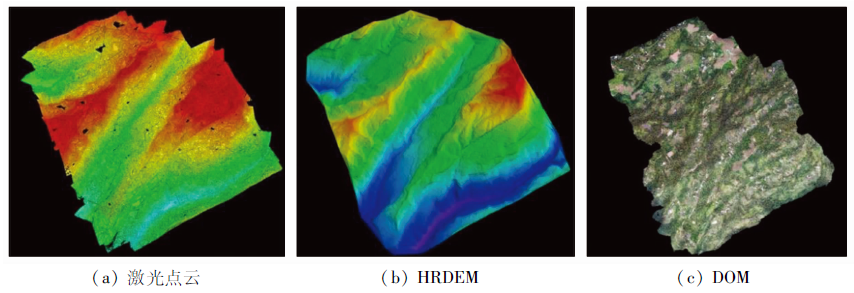
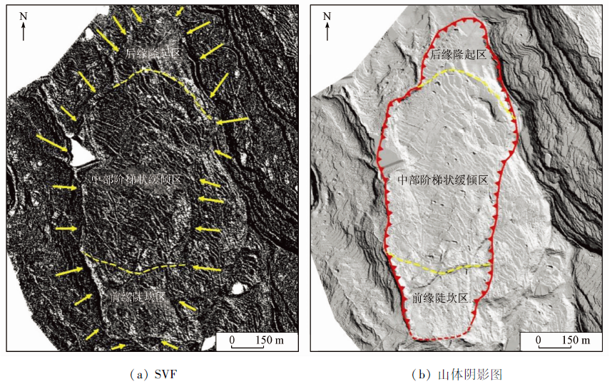
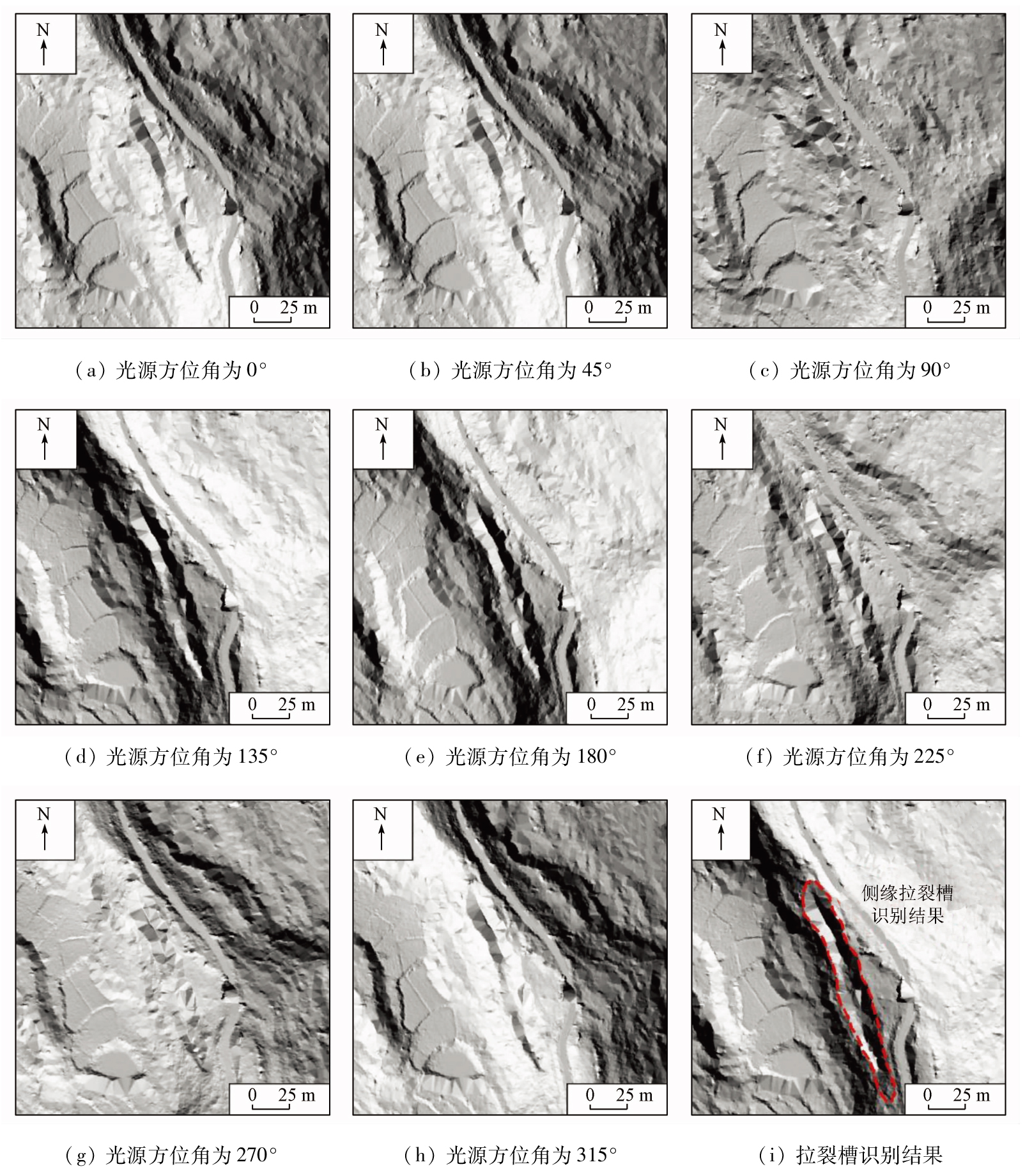
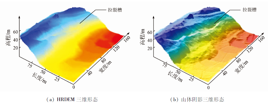
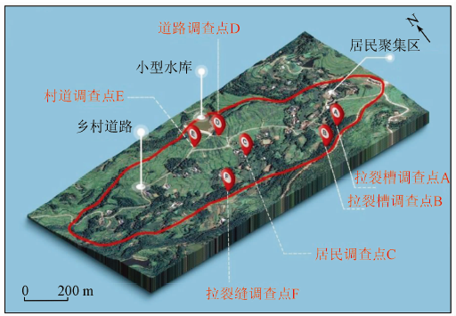
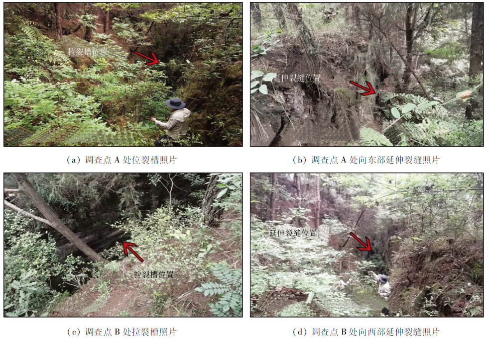
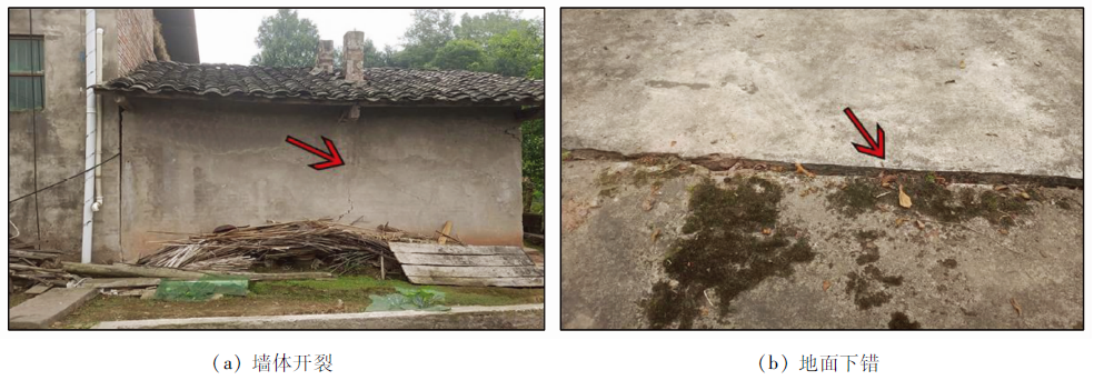
Abstract Flat landslides, typically characterized by crack grooves, are a common type of special disasters in southwestern China. However, the dense vegetation and complex terrain in disaster-developed areas limit the efficiency of conventional ground or remote sensing (RS) survey methods in the identification and extraction of disaster information. As one of the emerging remote sensing technologies, the airborne LiDAR technology and its data visualization analysis methods provide a new solution for the accurate identification of flat landslides. First, the high resolution digital elevation model (HRDEM) can be obtained using the UAV airborne LiDAR. Then, the HRDEM can be combined with visualization methods including sky view factor (SVF), hillshades, and 3D morphology simulation for the effective identification of flat landslides and their crack grooves. This study investigated the newly identified landslide hazard in the southern part of Nuoguzhai Village, Chunzai Town, Tongjiang County, northern Sichuan Province. The comprehensive RS identification method was used to realize the construction of landslide identification signs, the determination of the landslide boundary, the identification of crack groove position, and information extraction based on airborne LiDAR data. Combined with the results of field surveys, the effectiveness of the airborne LiDAR technology for the identification of flat landslides and their crack grooves in highly vegetation-covered areas was verified from both qualitative and quantitative aspects. The related study results can be used as a reference for the early identification, monitoring, and prevention of flat landslides.
|
| Keywords
flat landslides
crack groove
airborne LiDAR
HRDEM
visual analysis
|
|
|
|
Issue Date: 27 December 2022
|
|
|
| [1] |
王治华, 杜明亮, 郭兆成, 等. 缓倾地层滑坡地质力学模型研究——以冯店滑坡为例[J]. 地质力学学报, 2012, 18(2):97-109,186.
|
| [1] |
Wang Z H, Du M L, Guo Z C, et al. Molybdenite re-os isotopic dating of sangbujiala copper deposit in the south margin of the eastern Gangdese section,Tibet,and its geological implications[J]. Journal of Geomechanics, 2012, 18(2):97-109,186.
|
| [2] |
方贻立, 马明, 李聪, 等. 平推式滑坡致灾机理与减灾方法研究进展[J]. 长江科学院院报, 2013, 30(12):20-27.
|
| [2] |
Fang Y L, Ma M, Li C, et al. Research advances in translational landslide’s mechanism and risk mitigation[J]. Journal of Yangtze River Scientific Research Institute, 2013, 30(12):20-27.
|
| [3] |
张明, 胡瑞林, 殷跃平, 等. 川东缓倾红层中降雨诱发型滑坡机制研究[J]. 岩石力学与工程学报, 2014, 33(s2):3783-3790.
|
| [3] |
Zhang M, Hu R L, Yin Y P, et al. Study of mechanism of landslide induced by rainfall in gently inclined red stratum in east Sichuan basin[J]. Chinese Journal of Rock Mechanics and Engineering, 2014, 33(s2):3783-3790.
|
| [4] |
张倬元, 王士天, 王兰生. 工程地质分析原理[M]. 北京: 地质出版社, 1994:377-380.
|
| [4] |
Zhang Z Y, Wang S T, Wang L S. Principles of engineering geological analysis[M]. Beijing: Geological Publishing House, 1994:377-380.
|
| [5] |
吉随旺, 张倬元, 王凌云, 等. 近水平软硬互层斜坡变形破坏机制[J]. 中国地质灾害与防治学报, 2000(3):52-55.
|
| [5] |
Ji S W, Zhang Z Y, Wang L Y, et al. The mechanism of deformation and failure for the slope composed of nearly horizontal competent and incompetent intercalated rock mass strata[J]. Chinese Journal of Geological Hazards and Prevention, 2000(3):52-55.
|
| [6] |
黄润秋, 赵松江, 宋肖冰, 等. 四川省宣汉县天台乡滑坡形成过程和机理分析[J]. 水文地质工程地质, 2005(1):13-15.
|
| [6] |
Huang R Q, Zhao S J, Song X B, et al. The formation and mechanism analysis of Tiantai landslide,Xuanhan County,Sichuan Province[J]. Hydrogeology and Engineering Geology, 2005(1):13-15.
|
| [7] |
成国文, 李善涛, 李晓, 等. 万州近水平地层区堆积层滑坡成因与变形破坏特征[J]. 工程地质学报, 2008(3):17-23.
|
| [7] |
Cheng G W, Li S T, Li X, et al. Forming causes and deformation-destruction characters of accumulative stratum landslide in horizontal stratum in Wanzhou[J]. Hydrogeology and Engineering Geology, 2008(3):17-23.
|
| [8] |
Du Y, Xie M W, Jia J L. Stepped settlement: A possible mechanism for translational landslides[J]. Catena, 2020, 187:104365.
doi: 10.1016/j.catena.2019.104365
url: https://linkinghub.elsevier.com/retrieve/pii/S0341816219305077
|
| [9] |
杜岩, 谢谟文, 吴志祥, 等. 平推式滑坡成因机制及其稳定性评价[J]. 岩石力学与工程学报, 2019, 38(s1):2871-2880.
|
| [9] |
Du Y, Xie M W, Wu Z X, et al. Genetic mechanism about translational landslide and its safety evaluation[J]. Chinese Journal of Rock Mechanics and Engineering, 2019, 38(s1):2871-2880.
|
| [10] |
Juan J S, Xue L,Wang, H Y, et al. Effects of the attitude of dominant joints on the mobility of translational landslides[J]. Landslides, 2021, 18:2483-2498.
doi: 10.1007/s10346-021-01668-8
url: https://doi.org/10.1007/s10346-021-01668-8
|
| [11] |
Santangelo M, Cardinali M, Rossi M, et al. Remote landslide mapping using a laser rangefinder binocular and GPS[J]. Natural Hazards and Earth System Sciences, 2010, 10(12): 2539-2546.
|
| [12] |
许强, 董秀军, 李为乐. 基于天-空-地一体化的重大地质灾害隐患早期识别与监测预警[J]. 武汉大学学报(信息科学版), 2019, 44(7):957-966.
|
| [12] |
Xu Q, Dong X J, Li W L. Integrated space-air-ground early detection,monitoring and warning system for potential catastrophic geohazards[J]. Geomatics and Information Science of Wuhan University, 2019, 44(7):957-966.
|
| [13] |
许强, 李为乐, 董秀军, 等. 四川茂县叠溪镇新磨村滑坡特征与成因机制初步研究[J]. 岩石力学与工程学报, 2017, 36(11):2612-2628.
|
| [13] |
Xu Q, Li W L, Dong X J, et al. The Xinmocun landslide on June 24,2017 in Maoxian,Sichuan: Characteristics and failure mechanism[J]. Chinese Journal of Rock Mechanics and Engineering, 2017, 36(11):2612-2628.
|
| [14] |
IPCC. Climate change 2021:The physical science basis[M]. Cambridge: Cambridge University Press, 2021: 5-31.
|
| [15] |
张小红. 机载激光雷达测量技术理论与方法[M]. 武汉: 武汉大学出版社, 2007: 16-25.
|
| [15] |
Zhang X H. Airborne laser Radar technology theory and methods of measurement[M]. Wuhan: Wuhan University Press, 2007:16-25.
|
| [16] |
McKean J, Roering J. Objective landslide detection and surface morphology mapping using high-resolution airborne laser altimetry[J]. Geomorphology, 2004, 57(3-4): 331-351.
doi: 10.1016/S0169-555X(03)00164-8
url: https://linkinghub.elsevier.com/retrieve/pii/S0169555X03001648
|
| [17] |
Michel J, Thierry O, Antonio A, et al. Use of LIDAR in landslide investigations:A review[J]. Natural Hazards, 2012, 61(1):5-28.
doi: 10.1007/s11069-010-9634-2
url: http://link.springer.com/10.1007/s11069-010-9634-2
|
| [18] |
马晓雪, 吴中海, 李家存. LiDAR技术在地质环境中的主要应用与展望[J]. 地质力学学报, 2016, 22(1):93-103.
|
| [18] |
Ma X X, Wu Z H, Li J C. LiDAR technology and its application and prospect in geological environment[J]. Journal of Geomechanics, 2016, 22(1):93-103.
|
| [19] |
任治坤, 陈涛, 张会平, 等. LiDAR技术在活动构造研究中的应用[J]. 地质学报, 2014, 88(6):1196-1207.
|
| [19] |
Ren Z K, Chen T, Zhang H P, et al. LiDAR survey in active tectonics studies:An introduction and overview[J]. Acta Geologica Sinica, 2014, 88(6):1196-1207.
|
| [20] |
李占飞, 刘静, 邵延秀, 等. 基于LiDAR的海原断裂松山段断错地貌分析与古地震探槽选址实例[J]. 地质通报, 2016, 35(1):104-116.
|
| [20] |
Li Z F, Liu J, Shao Y X, et al. Tecto-geomorphic analysis and selection of trench sites along Haiyuan fault in Songshan site based on high-resolution airbone LiDAR data[J]. Geological Bulletin of China, 2016, 35(1):104-116.
|
| [21] |
肖春蕾, 郭兆成, 郑雄伟, 等. 机载LiDAR技术在地质调查领域中的几个典型应用[J]. 国土资源遥感, 2016, 28(1):136-143.doi:10.6046/gtzyyg.2016.01.20.
doi: 10.6046/gtzyyg.2016.01.20
|
| [21] |
Xiao C L, Guo Z C, Zheng X W, et al. Typical applications of airborne LiDAR technique in geological investigation[J]. Remote Sensing for Land and Resources, 2016, 28(1):136-143.doi:10.6046/gtzyyg.2016.01.20.
doi: 10.6046/gtzyyg.2016.01.20
|
| [22] |
郭晨, 许强, 董秀军, 等. 复杂山区地质灾害机载激光雷达识别研究[J]. 武汉大学学报(信息科学版), 2021, 46(10):1538-1547.
|
| [22] |
Guo C, Xu Q, Dong X J, et al. Geohazard recognition by airborne LiDAR technology in complex mountain areas[J]. Geomatics and Information Science of Wuhan University, 2021, 46(10):1538-1547.
|
| [23] |
沈开俊, 刘严松. 四川通江县地质灾害特征及影响因素分析[J]. 四川地质学报, 2010, 30(4):465-467,481.
|
| [23] |
Shen K J, Liu Y S. Geological hazards and their influence factors in Tongjiang,Sichuan[J]. Acta Geologica Sichuan, 2010, 30(4):465-467,481.
|
| [24] |
张涛, 谢忠胜, 石胜伟, 等. 川东红层缓倾岩质滑坡的演化过程及其识别标志探讨[J]. 工程地质学报, 2017, 25(2):496-503.
|
| [24] |
Zhang T, Xie Z S, Shi S W, et al. Discussion on evolution process of flat rock landslide and its identification in red strata at eastern Sichuan[J]. Journal of Engineering Geology, 2017, 25(2):496-503.
|
|
Viewed |
|
|
|
Full text
|
|
|
|
|
Abstract
|
|
|
|
|
Cited |
|
|
|
|
| |
Shared |
|
|
|
|
| |
Discussed |
|
|
|
|
 2022,
Vol. 34
2022,
Vol. 34