|
|
|
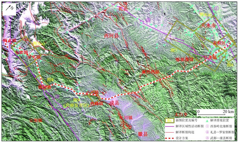
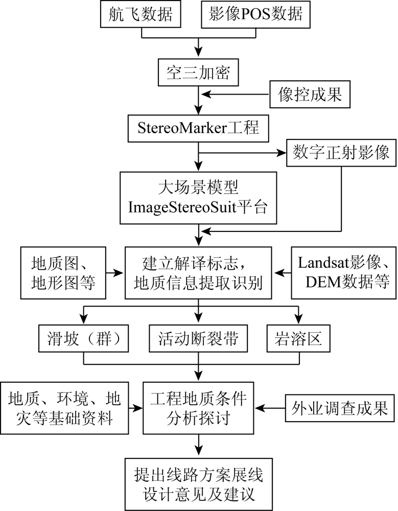
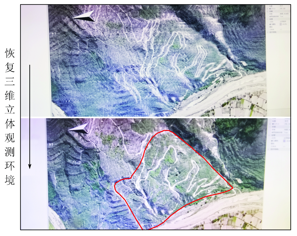
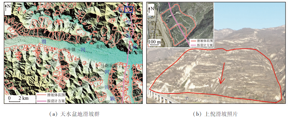
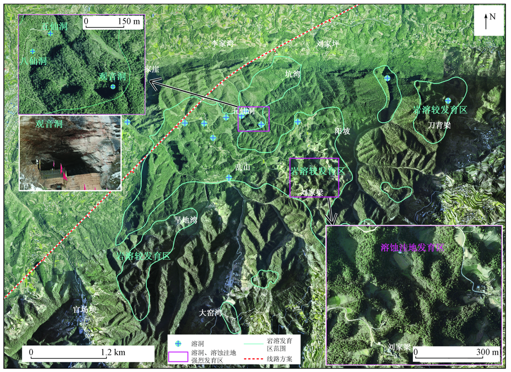
Abstract The Tianshui-Longnan Railway serves as an important project for guaranteeing Gansu Province’s development strategy of “consolidating the east, focusing on the west, deepening the south, and promoting the northward expansion”. This railway crosses the Qinling Mountains twice and passes through three distinct geomorphic units including the loess ridge, knoll, and gully areas, the moderately high mountainous area of the Tianshui-Xili basin, and the moderately high mountainous area of the Qinling Mountains from north to south. The complex geological tectonic setting and the intensive regional Cenozoic tectonic movements lead to environmental geological problems, such as large-scale landslide groups, Holocene active faults, and karst collapse along the railway line, which severely restrain the early-stage design of the line scheme and affect the safety and stability of the later construction and operation of the railway. By fully utilizing surveyed aerial remote sensing data, this study interpreted and analyzed various geological problems along the whole railway in detail according to high-precision stereo images and orthophoto images of realistic scenes. Moreover, this study assessed the scope, scale, stability, and possible impacts of the various geological problems on the line scheme by combining the data from field surveys. The results of this study will provide strong technical support for both the line scheme design and the field geological surveys of the Tianshui-Longnan Railway.
|
| Keywords
remote sensing technology
realistic scene
Tianshui-Longnan Railway
landslide
active fault
karst
|
|
|
|
Issue Date: 21 September 2022
|
|
|
| [1] |
卓宝熙, 甄春相. 遥感技术在铁路工程地质勘察中的应用[J]. 铁道工程学报, 2005, 12(s1):398-406.
|
| [1] |
Zhuo B X, Zhen C X. Application of remote sensing technology in the railway engineering geology[J]. Journal of Railway Engineering Society, 2005, 12(s1):398-406.
|
| [2] |
贾伟洁, 王治华. 基于高分辨率遥感影像的滑坡活动特征及稳定性分析——以东苗家滑坡为例[J]. 国土资源遥感, 2019, 31(4):174-181.doi: 10.6046/gtzyyg.2019.04.23.
doi: 10.6046/gtzyyg.2019.04.23
|
| [2] |
Jia W J, Wang Z H. Landslide activity characteristics and stability analysis based on high-resolution remote sensing image:A case study of Dongmiaojia landslide[J]. Remote Sensing for Land and Resources, 2019, 31(4):174-181.doi: 10.6046/gtzyyg.2019.04.23.
doi: 10.6046/gtzyyg.2019.04.23
|
| [3] |
夏涛, 杨武年, 马安青. 遥感影像三维可视化在岩溶漏斗解译中的应用[J]. 测绘科学, 2009(6):266-267.
|
| [3] |
Xia T, Yang W N, Ma A Q. Application of 3D visualization of remote sensing images in doline interpretation[J]. Science of Surveying and Mapping, 2009(6):266-267.
|
| [4] |
赵卫东, 郑勇, 章浩南, 等. 基于多源数据的郯庐断裂带安徽段遥感解译及其空间分布特征[J]. 国土资源遥感, 2019, 31(4):79-87.doi: 10.6046/gtzyyg.2019.04.11.
doi: 10.6046/gtzyyg.2019.04.11
|
| [4] |
Zhao W D, Zhen Y, Zhang H N, et al. Remote sensing interpretation and spatial distribution characteristics of the Anhui segment of Tanlu fault zone based on multi-source data[J]. Remote Sensing for Landand Resources, 2019, 31(4):79-87.doi: 10.6046/gtzyyg.2019.04.11.
doi: 10.6046/gtzyyg.2019.04.11
|
| [5] |
刘亚林. 多源遥感技术在铁路工程地质勘察中的应用研究[J]. 铁道标准设计, 2013(5):13-15.
|
| [5] |
Liu Y L. Application research of multisource remote sensing technology in railway geological surveying[J]. Railway Standard Design, 2013(5):13-15.
|
| [6] |
张占忠. 铁路大场景立体影像模型制作关键技术及应用[J]. 铁道工程学报, 2020, 37(4):11-16.
|
| [6] |
Zhang Z Z. Key Technologies for making large scene stereo model and its application in railway survey and design[J]. Journal of Railway Engineering Society, 2020, 37(4):11-16.
|
| [7] |
吕慧玲. 真实感场景模型制作工艺及质量控制方法[J]. 铁道标准设计, 2016(9):28-31.
|
| [7] |
Lyu H L. Workmanship and quality control of realistic scene model[J]. Railway Standard Design, 2016(9):28-31.
|
| [8] |
孟祥连, 周福军. 真实感场景遥感技术在铁路工程勘察中的应用[J]. 西南交通大学学报, 2017, 52(5):949-955.
|
| [8] |
Meng X L, Zhou F J. Application of railway engineering survey based on remote sensing technology for realistic scenes[J]. Journal of Southwest Jiaotong University, 2017, 52(5):949-955.
|
| [9] |
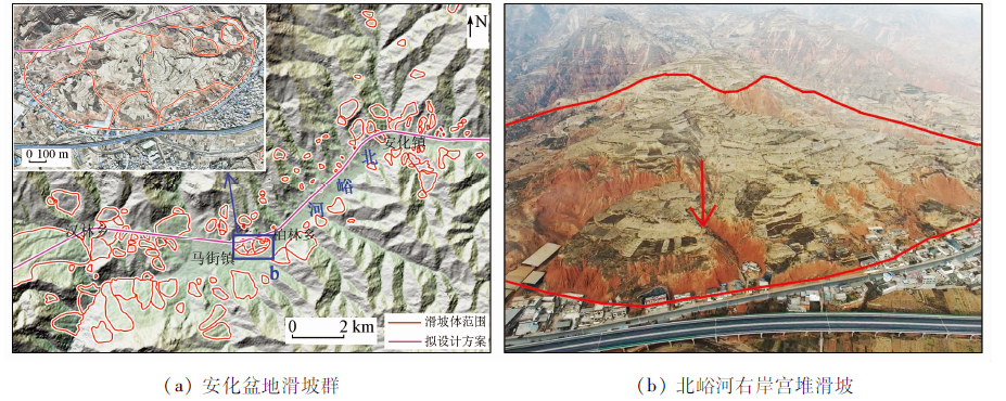
田尤, 杨为民, 黄晓, 等. 天水市麦积区幅黄土滑坡发育分布特征及其孕灾因素分析[J]. 地质力学学报, 2016, 22(1):25-38.
|
| [9] |
Tian Y, Yang W M, Huang X, et al. Distribution characteristics and inducing factors of loess landslide in Maiji mappablen unit,Tianshui[J]. Journal of Geomechanics, 2016, 22(1):25-38.
|
| [10] |
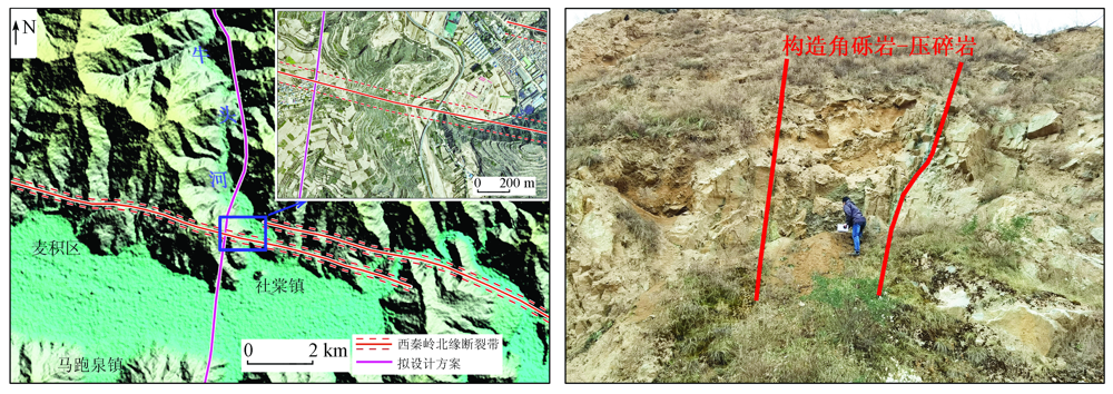
王志才, 张培震, 张广良, 等. 西秦岭北缘构造带的新生代构造活动——兼论对青藏高原东北缘形成过程的指示意义[J]. 地学前缘, 2006, 13(4):119-135.
|
| [10] |
Wang Z C, Zhang P Z, Zhang G L, et al. Tertiary tectonic activities of the north frontal fault zone of the west Qinling Mountains:Implications for the growth of the northeastern margin of the Qinghai-Tibetan Plateau[J]. Earth Science Frontiers, 2006, 13(4):119-135.
|
| [11] |
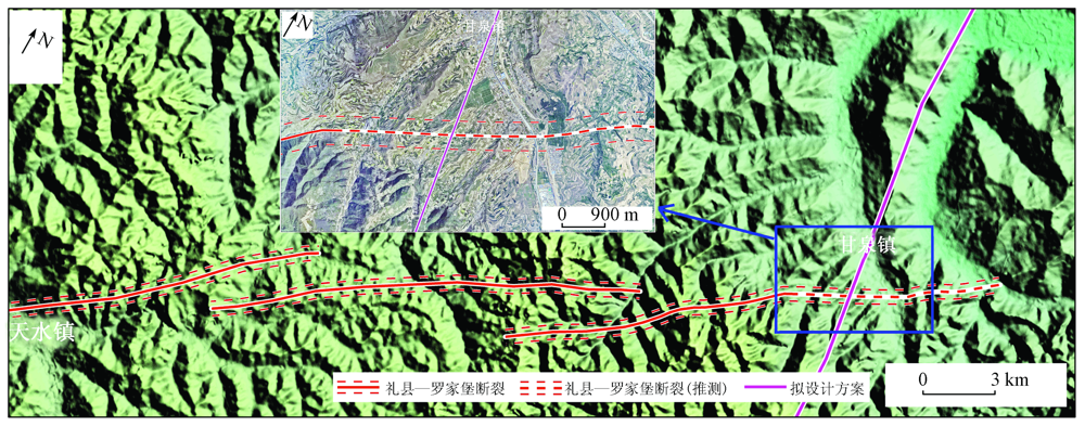
杨晓平, 冯希杰, 黄雄南, 等. 礼县—罗家堡断裂晚第四纪活动特征:兼论1654年礼县8级地震孕震机制[J]. 地球物理学报, 2015, 58(2):504-519.
|
| [11] |
Yang X P, Feng X J, Huang X N, et al. The late quaternary activity characteristics of the Lixian-Luojiabu fault:A discussion on the seismogenic mechanism of the Lixian M8 earthquake in 1654[J]. Chinese Journal of Geophysics, 2015, 58(2):504-519.
|
| [12] |
陈鹏. 西秦岭地区晚新生代构造演化[D]. 北京: 中国地质科学院, 2016.
|
| [12] |
Chen P. Late cenozoic tectonic evolution in the west Qinling areasa case study of Tianshui basin[D]. Beijing: Chinese Academy of Geological Sciences, 2016.
|
| [13] |
贾伟. 康县—武都断裂新活动性及其地震危险性研究[D]. 兰州: 中国地震局兰州地震研究所, 2012.
|
| [13] |
Jia W. Activity on Kangxian-Wudu fault zone and its’seismic hazard assessment[D]. Lanzhou: Lanzhou Institute of Seismology,CEA, 2012.
|
| [14] |
张帅, 孙萍, 邵铁全, 等. 甘肃天水黄土梁峁区强震诱发滑坡特征研究[J]. 工程地质学报, 2016, 24(4):519-526.
|
| [14] |
Zhang S, Sun P, Shao T Q, et al. Earthquake-Triggered landslides in Tianshui loess hilly region,Gansu Province,China[J]. Journal of Engineering Geology, 2016, 24(4):519-526.
|
| [15] |
匡永生. 秦安—天水地区新生代盆地沉积演化[D]. 兰州: 兰州大学, 2007.
|
| [15] |
Kuang Y S. The depositional evolution of neozoic basin in Tianshui-Qin’an area[D]. Lanzhou: Lanzhou University, 2007.
|
|
Viewed |
|
|
|
Full text
|
|
|
|
|
Abstract
|
|
|
|
|
Cited |
|
|
|
|
| |
Shared |
|
|
|
|
| |
Discussed |
|
|
|
|
 2022,
Vol. 34
2022,
Vol. 34
 )
)