Please wait a minute...
 
Remote Sensing for Land & Resources    2019, Vol. 31 Issue (4) : 174-181     DOI: 10.6046/gtzyyg.2019.04.23
|
Landslide activity characteristics and stability analysis based on high-resolution remote sensing image: A case study of Dongmiaojia landslide
Weijie JIA1,2, Zhihua WANG1
1. Institute of Geographic Sciences and Natural Resources Research, China Academy of Sciences, Beijing 100101, China
2. China Aero Geophysical Survey and Remote Sensing Center for Natural Resources, Beijing 100083, China
Download: PDF(7870 KB)   HTML
Export: BibTeX | EndNote | Reference Manager | ProCite | RefWorks    
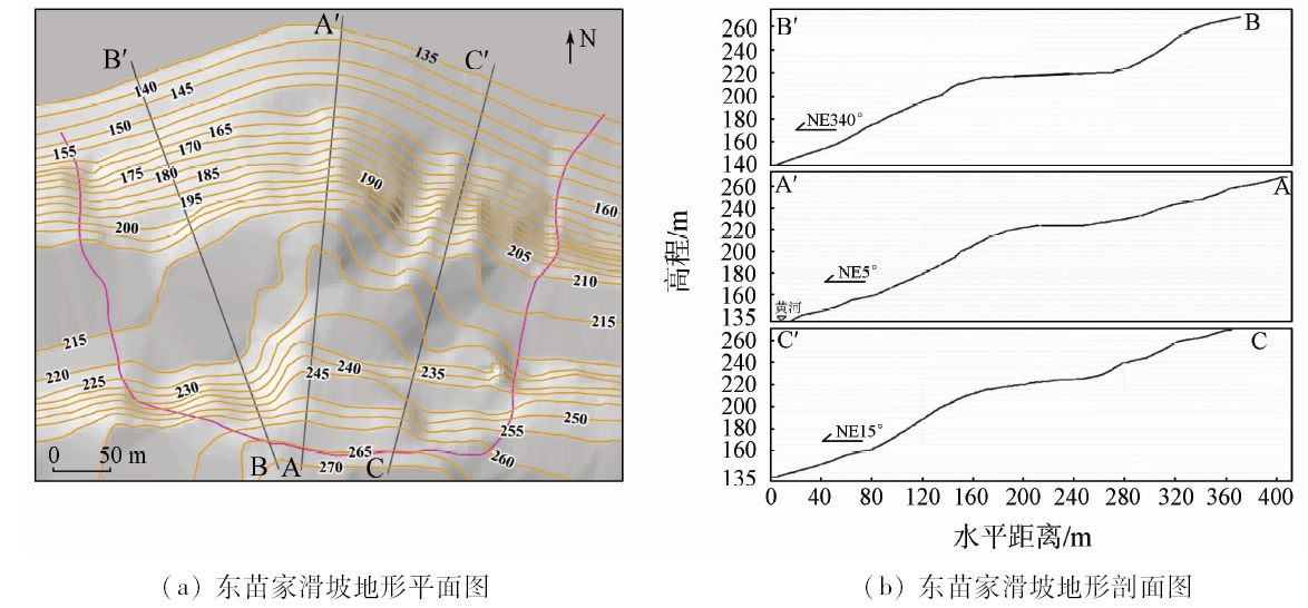
Abstract  

Based on the digital landslide technology, the authors employed revised 10 high-resolution remote sensing images between 2002 and 2016 as remote sensing image information source, densified ASTER DEM data as landslide elevation information source, and 1:200 000 Luoyang City regional geological maps as the geological environment source and, in combination with Dongmiaojia landslide, analyzed the creation conditions and active characteristics of the landslide, and predicted the present stability situation of landslide. The result shows that the active process of Dongmiaojia landslide can be divided into four stages, i.e., the first landslide activity, the subsequent traction activity, the front landslide activity and the follow-up activity, which formed topography of four level terraces with seven platforms and the front steep slope. The estimation of the total size of the Dongmiaojia landslide is 425.4×10 4 m 3. The comparison of ten high-resolution images indicates that there has been no obvious deformation and displacement in the Dongmiaojia landslide in recent years.

Keywords Dongmiaojia landslide      digital landslide technology      interpretation basis      activity characteristics      four level terraces     
:  TP79  
Issue Date: 03 December 2019
Service
E-mail this article
E-mail Alert
RSS
Articles by authors
Weijie JIA
Zhihua WANG
Cite this article:   
Weijie JIA,Zhihua WANG. Landslide activity characteristics and stability analysis based on high-resolution remote sensing image: A case study of Dongmiaojia landslide[J]. Remote Sensing for Land & Resources, 2019, 31(4): 174-181.
URL:  
https://www.gtzyyg.com/EN/10.6046/gtzyyg.2019.04.23     OR     https://www.gtzyyg.com/EN/Y2019/V31/I4/174
Fig.1  Location and regional environment of Dongmiaojia landslide
序号 接收日期 影像特征
1 2002-09-08 初秋,清晰显示滑坡各部分特征
2 2012-06-22 初夏,植被覆盖,部分滑坡细节不清晰
3 2012-12-27 初冬,基本清楚显示滑坡各部分特征
4 2013-03-08 初春,基本清楚显示滑坡各部分特征
5 2014-11-13 秋末,清楚显示滑坡各部分特征
6 2015-03-13 春,雾重,影像不清晰
7 2015-07-01 夏,植被覆盖,部分滑坡细节不清晰
8 2015-12-14 初冬,基本清楚显示滑坡各部分特征
9 2016-09-29 深秋,植被覆盖,部分滑坡细节不清晰
Tab.1  Remote sensing information sources
Fig.2  Image and topography overlay chart of Dongmiaojia landslide
Fig.3  Topographic plane and profile of Dongmiaojia landslide
Fig.4  Slope map of Dongmiaojia landslide
Fig.5  Remote sensing interpretation of dongmiaojia landslide
编号 平均高程/m 面积/ m2
T1 215 1 315
T2 217 7 224
T3 219 2 196
T4 233 2 641
T5 242 1 745
T6 248 3 080
T7 263 3 398
Tab.2  Average elevations and areas of the platforms on the landslide
Fig.6  Main profile of Dongmiaojia landslide
Fig.7  Changes of the nine Dongmiaojia landslide images from 2002 to 2016
[1] 李清波, 徐国刚, 应敬浩 . 黄河小浪底东苗家滑坡稳定性分析及整治措施[ C]//中国水利学会一九九九年优秀论文集.北京: 1999: 367-371.
[1] Li Q B, Xu G G, and Ying J H . Stability analysis and treatment measures of Dongmiaojia landslide in Xiaolangdi Dam of Yellow river[ C].Chinese Water Conservancy Society Excellent Essays in 1999.Beijing: 1999: 367-371.
[2] 王小波, 徐文杰, 张丙印 , 等. DDA强度折减法及其在东苗家滑坡中的应用[J]. 清华大学学报(自然科学版), 2012,52(6):814-820.
[2] Wang X B, Xu W J, and Zhang B Y , et al., Strength reduction of DDA and its application in Dongmiaojia landslide[J]. Journal of Tsinghua University (Science & Technology), 2012,52(6):814-820.
[3] Xu W J, Jie Y X, Li Q B , et al. Genesis,mechanism,and stability of the Dongmiaojia landslide,Yellow River,China[J]. International Journal of Rock Mechanics & Mining Sciences, 2014,67(2):57-68.
[4] 王治华 . 遥感技术在我国水电建设前期工作中的应用[J]. 国土资源遥感, 1995,7(3):1-8.doi: 10.6046/gtzyyg.1995.03.01
doi: 10.6046/gtzyyg.1995.03.01
[4] Wang Z H . The application of remote sensing technique to the hydro-electric construction of earlier stage in China[J]. Remote Sensing for Land and Resource, 1995,7(3):1-8.doi: 10.6046/gtzyyg.1995.03.01
[5] 王治华 . 数字滑坡技术及其应用[J]. 现代地质, 2005,19(2):157-164.
[5] Wang Z H , Progress and applications for digital landslide[J]. Geoscience, 2005,19(2):157-164.
[6] 王治华 . 滑坡遥感[M]. 北京: 科学出版社, 2012.
[6] Wang Z H. Remote Sensing for Landslide[M]. Beijing: Science Press, 2012.
[7] 王治华 . 数字滑坡技术及其典型应用[J]. 中国地质调查, 2016,3(3):47-54.
[7] Wang Z H . Digital landslide technology and its typical application[J]. Geological Survey of China, 2016,3(3):47-54.
[8] 戴其祥 . 黄河小浪底水库工程坝区构造应力场的恢复和分析[J].人民黄河,1991(5):43-48.
[8] Dai Q X . Return and analysis of structural stress field in Xiaolangdi dam site Area[J].Yellow River,1991(5):43-48.
[9] 李志建, 滕伟福, 周爱国 , 等. 黄河小浪底水库诱发地震预测[J]. 地质灾害与环境保护, 2000,11(4):306-309.
[9] Li Z J, Teng W F, and Zhou A G , et al. The prediction of reservoir-induced earthquake in Xiaolangdi area,Yellow River[J]. Journal of Geological Hazards and Environment Preservation, 2000,11(4):306-309.
[10] 童立强, 郭兆成 . 典型滑坡遥感影像特征研究[J]. 国土资源遥感, 2013,25(1):86-92.doi: 10.6046/gtzyyg.2013.01.16.
doi: 10.6046/gtzyyg.2013.01.16
[10] Tong L Q, Guo Z C . A study of remote sensing image features of typical landslides[J]. Remote Sensing for Land and Resource, 2013,25(1):86-92.doi: 10.6046/gtzyyg.2013.01.16.
[11] 胡江春, 邹正盛, 李晨 , 等. 东苗家滑坡稳定性分析及处理方式研究[J]. 中原工学院学报, 2015,26(6):57-60.
[11] Hu J C, Zhou Z S, Li C , et al. Dongmiaojia landslide stability evaluation and treatment method[J]. Journal of Zhongyuan University of Technology. 2015,26(6):57-60.
[12] Jiang X, Wan L, Wang X , et al. Permeability Heterogeneity in a Fractured Sandstone-Mudstone Rock Mass in Xiaolangdi Dam Site,Central China[J]. Acta Geologica Sinica(English,Edition), 2009,83(5):962-970.
[13] 王治华, 贾伟洁 . 基于数字滑坡技术的三峡新滩滑坡研究[J]. 工程地质学报, 2017,25(3):762-771.
[13] Wang Z H, Jia W J . Study on Xintan landslide in Three Gorge based on digital landslide technique[J]. Journal of Engineering Geology, 2017,25(3):762-771.
[1] SONG Qi, FENG Chunhui, MA Ziqiang, WANG Nan, JI Wenjun, PENG Jie. Simulation of land use change in oasis of arid areas based on Landsat images from 1990 to 2019[J]. Remote Sensing for Natural Resources, 2022, 34(1): 198-209.
[2] REN Chaofeng, PU Yuchi, ZHANG Fuqiang. A method for extracting match pairs of UAV images considering geospatial information[J]. Remote Sensing for Natural Resources, 2022, 34(1): 85-92.
[3] ZANG Liri, YANG Shuwen, SHEN Shunfa, XUE Qing, QIN Xiaowei. A registration algorithm of images with special textures coupling a watershed with mathematical morphology[J]. Remote Sensing for Natural Resources, 2022, 34(1): 76-84.
[4] PAN Jianping, XU Yongjie, LI Mingming, HU Yong, WANG Chunxiao. Research and development of automatic detection technologies for changes in vegetation regions based on correlation coefficients and feature analysis[J]. Remote Sensing for Natural Resources, 2022, 34(1): 67-75.
[5] XUE Bai, WANG Yizhe, LIU Shuhan, YUE Mingyu, WANG Yiying, ZHAO Shihu. Change detection of high-resolution remote sensing images based on Siamese network[J]. Remote Sensing for Natural Resources, 2022, 34(1): 61-66.
[6] JIANG Na, CHEN Chao, HAN Haifeng. An optimization method of DEM resolution for land type statistical model of coastal zones[J]. Remote Sensing for Natural Resources, 2022, 34(1): 34-42.
[7] WU Fang, LI Yu, JIN Dingjian, LI Tianqi, GUO Hua, ZHANG Qijie. Application of 3D information extraction technology of ground obstacles in the flight trajectory planning of UAV airborne geophysical exploration[J]. Remote Sensing for Natural Resources, 2022, 34(1): 286-292.
[8] WANG Qian, REN Guangli. Application of hyperspectral remote sensing data-based anomaly extraction in copper-gold prospecting in the Solake area in the Altyn metallogenic belt, Xinjiang[J]. Remote Sensing for Natural Resources, 2022, 34(1): 277-285.
[9] LIU Wen, WANG Meng, SONG Ban, YU Tianbin, HUANG Xichao, JIANG Yu, SUN Yujiang. Surveys and chain structure study of potential hazards of ice avalanches based on optical remote sensing technology: A case study of southeast Tibet[J]. Remote Sensing for Natural Resources, 2022, 34(1): 265-276.
[10] YAO Jinxi, ZHANG Zhi, ZHANG Kun. An analysis of the characteristics, causes, and trends of spatio-temporal changes in vegetation in the Nuomuhong alluvial fan based on Google Earth Engine[J]. Remote Sensing for Natural Resources, 2022, 34(1): 249-256.
[11] WU Yijie, KONG Xuesong. Simulation and development mode suggestions of the spatial pattern of “ecology-agriculture-construction” land in Jiangsu Province[J]. Remote Sensing for Natural Resources, 2022, 34(1): 238-248.
[12] ZHANG Qinrui, ZHAO Liangjun, LIN Guojun, WAN Honglin. Ecological environment assessment of three-river confluence in Yibin City using improved remote sensing ecological index[J]. Remote Sensing for Natural Resources, 2022, 34(1): 230-237.
[13] HU Yingying, DAI Shengpei, LUO Hongxia, LI Hailiang, LI Maofen, ZHENG Qian, YU Xuan, LI Ning. Spatio-temporal change characteristics of rubber forest phenology in Hainan Island during 2001—2015[J]. Remote Sensing for Natural Resources, 2022, 34(1): 210-217.
[14] SUN Yiming, ZHANG Baogang, WU Qizhong, LIU Aobo, GAO Chao, NIU Jing, HE Ping. Application of domestic low-cost micro-satellite images in urban bare land identification[J]. Remote Sensing for Natural Resources, 2022, 34(1): 189-197.
[15] ZHENG Xiucheng, ZHOU Bin, LEI Hui, HUANG Qiyu, YE Haolin. Extraction and spatio-temporal change analysis of the tidal flat in Cixi section of Hangzhou Bay based on Google Earth Engine[J]. Remote Sensing for Natural Resources, 2022, 34(1): 18-26.
Viewed
Full text


Abstract

Cited

  Shared   
  Discussed   
京ICP备05055290号-2
Copyright © 2017 Remote Sensing for Natural Resources
Support by Beijing Magtech