|
|
 |
|

|
|
|
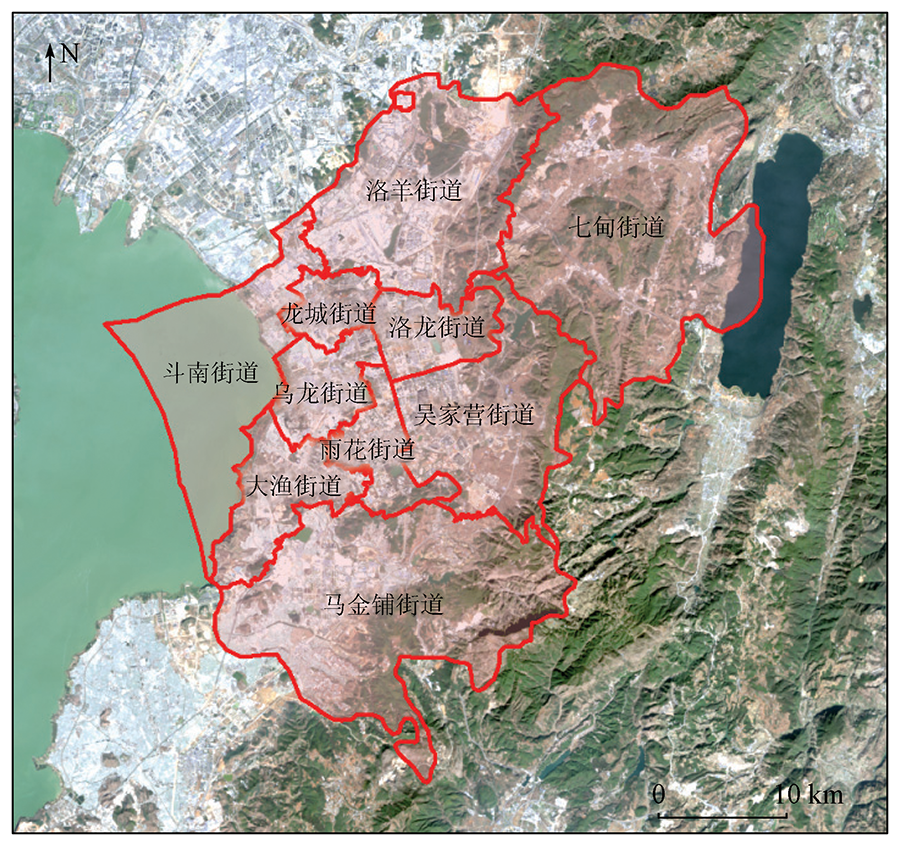
Spatiotemporal evolution of impervious surface and the driving factors in Chenggong District,Kunming City |
LI Yimin1,2( ), YANG Shuting1, WU Bowen1, LIANG Yuxi1, MENG Yueyue3 ), YANG Shuting1, WU Bowen1, LIANG Yuxi1, MENG Yueyue3 |
1. School of Earth Sciences, Yunnan University, Kunming 650500, China
2. Research Center of Domestic High-Resolute Satellite Remote Sensing Geological Engineering, Kunming 650500, China
3. China Aero Geophysical Survey and Remote Sensing Center for Natural Resouces, Beijing 100083, China |
|
|
|
|
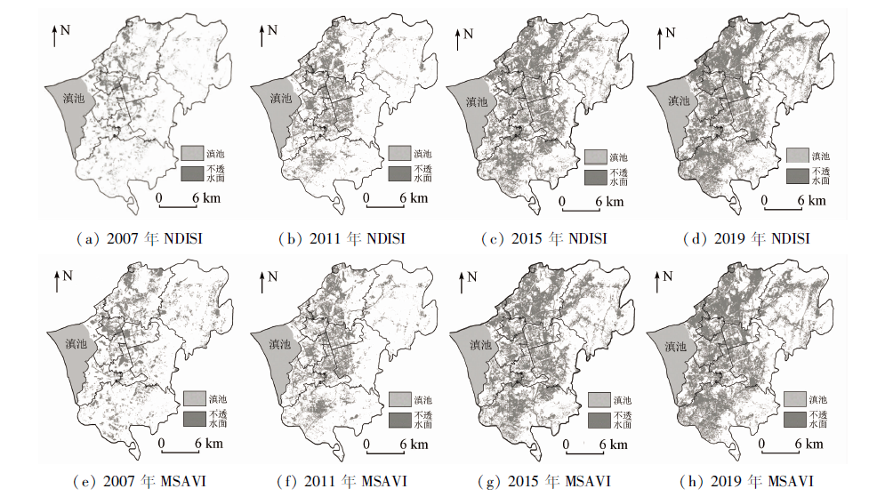
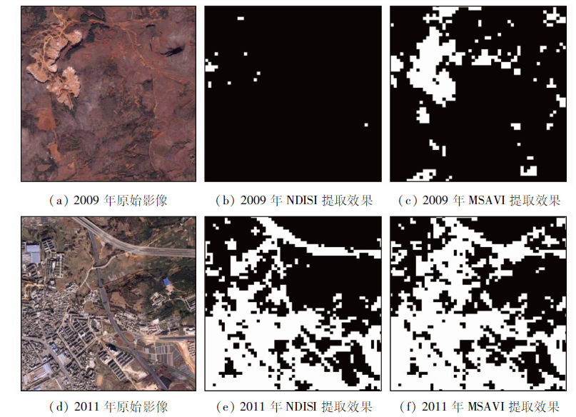
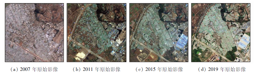
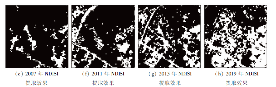
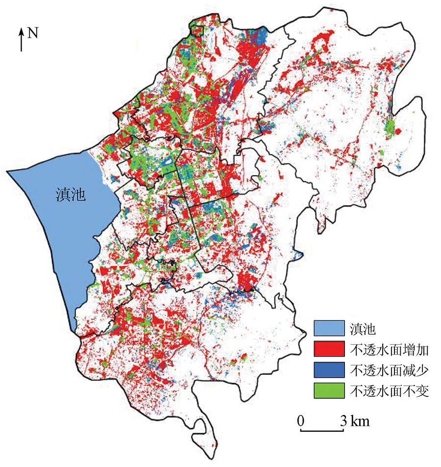
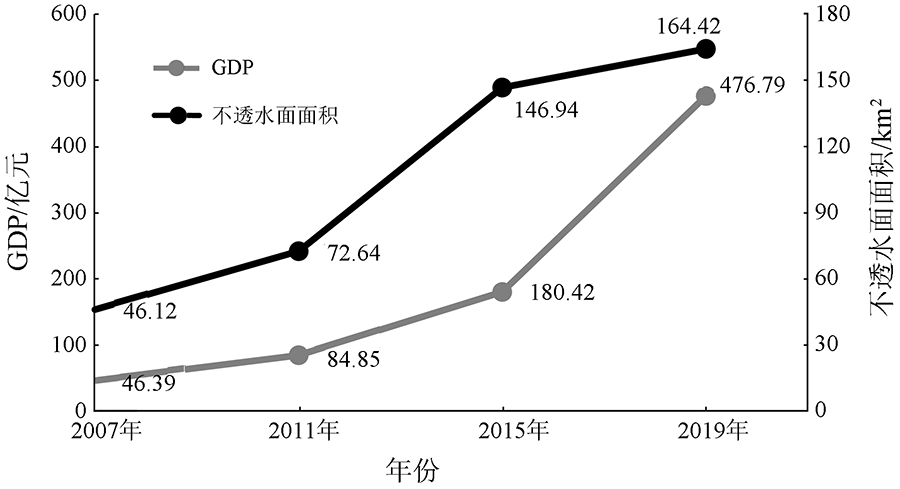
Abstract Impervious surface is a key factor to measure the urban ecological environment. It is of great significance for urban development planning to grasp the dynamic changes of impervious surfaces timely and accurately. Taking the Chenggong District of Kunming City as an example, based on the Landsat images in 2007, 2011, 2015, and 2019, the comparative study of normalized difference impervious surface index (NDISI) and modified soil adjusted vegetation index(MSAVI) was carried out to analyze the spatial and temporal evolution characteristics of impervious surface. The results showed that: ①As the extraction accuracy and Kappa coefficient of NDISI were 87.01% and 0.81, respectively, which were better than MSAVI’s 81.78% and 0.75, this paper selected the NDISI method to extract impervious surfaces in the Chenggong District;② the impervious surface area extracted in this paper increased from 46.12 km2 in 2007 to 72.64 km2 in 2011, 146.94 km2 in 2015 and 164.42 km2 in 2019, especially from 2011 to 2015, the impervious surface area had the fastest growth rate and nearly doubled. The changes to the impervious surface in Chenggong District are mainly influenced by such factors as national policies, urban planning, topographic factors, and traffic development. The impervious surface area along the Dianchi Lake in the west of Chenggong District and several administrative regions in the middle of Chenggong District developed rapidly, which brings certain pressure on the prevention and control of waterlogging in urban areas and the Dianchi Lake area. In the process of future urban planning, the expansion scope and speed of impervious surfaces should be well controlled to avoid ecological and environmental problems caused by the unreasonable spatial patterns of impervious surfaces.
|
| Keywords
impervious surface area
extraction by remote sensing
spatiotemporal characteristics
driving force
Chenggong District
|
|
|
|
Issue Date: 20 June 2022
|
|
|
| [1] |
徐涵秋, 王美雅. 地表不透水面信息遥感的主要方法分析[J]. 遥感学报, 2016, 20(5):1270-1289.
|
| [1] |
Xu H Q, Wang M Y. Remote sensing-based retrieval of ground impervious surfaces[J]. Journal of Remote Sensing, 2016, 20(5): 1270-1289.
|
| [2] |
蔡博文, 王树根, 王磊, 等. 基于深度学习模型的城市高分辨率遥感影像不透水面提取[J]. 地球信息科学学报, 2019, 21(9):1420-1429.
doi: 10.12082/dqxxkx.2019.180679
|
| [2] |
Cai B W, Wang S G, Wang L, et al. Extraction of urban impervious surface from high-resolution remote sensing imagery based on deep learning[J]. Journal of Geo-Information Science, 2019, 21(9):1420-1429.
|
| [3] |
周正龙, 沙晋明, 范跃新, 等. 厦门市不透水面景观格局时空变化及驱动力分析[J]. 应用生态学报, 2020, 31(1):230-238.
|
| [3] |
Zhou Z L, Sha J M, Fan Y X, et al. Temporal and spatial variations of impervious surface landscape pattern and the driving factors in Xiamen City,China[J]. Chinese Journal of Applied Ecology, 2020, 31(1):230-238.
|
| [4] |
Omurakunova G, Bao A M, Xu W Q, et al. Expansion of impervious surfaces and their driving forces in highly urbanized cities in Kyrgyzstan[J]. International Journal of Environmental Research and Public Health, 2020, 17(1):362.
doi: 10.3390/ijerph17010362
url: https://www.mdpi.com/1660-4601/17/1/362
|
| [5] |
李涵, 李龙, 张婷, 等. 徐州市中心城区不透水面时空异质性分析[J]. 长江流域资源与环境, 2019, 28(3):668-680.
|
| [5] |
Li H, Li L, Zhang T, et al. Mapping and characterizing the spatio-temporal heterogeneity of impervious surface in Xuzhou urban area[J]. Resources and Environment in the Yangtze Basin, 2019, 28(3):668-680.
|
| [6] |
刘畅, 杨康, 程亮, 等. Landsat8不透水面遥感信息提取方法对比[J]. 国土资源遥感, 2019, 31(3):148-156.doi: 10.6046/gtzyyg.2019.03.19.
doi: 10.6046/gtzyyg.2019.03.19
|
| [6] |
Liu C, Yang K, Cheng L, et al. Comparison of Landsat8 impervious surface extraction methods[J]. Remote Sensing for Land and Resources, 2019, 31(3): 148-156.doi: 10.6046/gtzyyg.2019.03.19.
doi: 10.6046/gtzyyg.2019.03.19
|
| [7] |
周玄德, 郭华东, 孜比布拉·司马义.城市扩张过程中不透水面空间格局演变及其对地表温度的影响——以乌鲁木齐市为例[J]. 生态学报, 2018, 38(20):7336-7347.
|
| [7] |
Zhou X D, Guo H D, Zibibula S. Spatial pattern evolution of impervious surfaces and its influence on surface temperature in the process of urban expansion: A case study of Urumqi[J]. Acta Ecologica Sinica, 2018, 38(20):7336-7347.
|
| [8] |
帅艳民, 马现伟, 曲歌, 等. 协同多时相波谱特征的不透水面信息级联提取[J]. 地球信息科学学报, 2021, 23(1):171-186.
doi: 10.12082/dqxxkx.2021.200236
|
| [8] |
Shuai Y M, Ma X W, Qu G, et al. Cascade extraction of impervious surface information based on the signature of temporal spectrum[J]. Journal of Geo-Information Science, 2021, 23(1):171-186.
|
| [9] |
Yang J, He Y. Automated mapping of impervious surfaces in urban and suburban areas: Linear spectral unmixing of high spatial resolution imagery[J]. International Journal of Applied Earth Observation and Geoinformation, 2017, 54:53-64.
doi: 10.1016/j.jag.2016.09.006
url: https://linkinghub.elsevier.com/retrieve/pii/S0303243416301635
|
| [10] |
吴溪, 郭斌, 陈忠升, 等. 基于Landsat影像的环胶州湾不透水面格局演变过程[J]. 资源科学, 2018, 40(11):2260-2269.
|
| [10] |
Wu X, Guo B, Chen Z S, et al. Spatio-temporal dynamic characterization of impervious surface in the Jiaozhou Bay based on Landsat imagery[J]. Resources Science, 2018, 40(11):2260-2269.
|
| [11] |
李波, 黄敬峰, 吴次芳. 基于热红外遥感数据和光谱混合分解模型的城市不透水面估算[J]. 自然资源学报, 2012, 27(9):1590-1600.
|
| [11] |
Li B, Huang J F, Wu C F. Estimating urban impervious surface based on thermal infrared remote sensing data and a spectral mixture analysis model[J]. Journal of Natural Resources, 2012, 27(9):1590-1600.
|
| [12] |
Yang L, Huang C, Homer C G, et al. An approach for mapping large area impervious surfaces: Synergistic use of Landsat-7 ETM+ and high spatial resolution imagery[J]. Canadian Journal of Remote Sensing, 2003, 29(2):230-240.
doi: 10.5589/m02-098
url: http://www.tandfonline.com/doi/abs/10.5589/m02-098
|
| [13] |
张路, 高志宏, 廖明生, 等. 利用多源遥感数据进行城市不透水面覆盖度估算[J]. 武汉大学学报(信息科学版), 2010, 35(10):1212-1216.
|
| [13] |
Zhang L, Gao Z H, Liao M S, et al. Estimating urban impervious surface percentage with multisource remote sensing data[J]. Geomatics and Information Science of Wuhan University, 2010, 35(10):1212-1216.
|
| [14] |
蔡耀通, 刘书彤, 林辉, 等. 基于多源遥感数据的CNN水稻提取研究[J]. 国土资源遥感, 2020, 32(4):97-104.doi: 10.6046/gtzyyg.2020.04.14.
doi: 10.6046/gtzyyg.2020.04.14
|
| [14] |
Cai Y T, Liu S T, Lin H, et al. Extraction of paddy rice based on convolutional neural network using multi- source remote sensing data[J]. Remote Sensing for Land and Resources, 2020, 32(4):97-104.doi: 10.6046/gtzyyg.2020.04.14.
doi: 10.6046/gtzyyg.2020.04.14
|
| [15] |
赵怡, 许剑辉, 钟凯文, 等. 基于Sentinel-2A和Landsat8的城市不透水面的提取[J]. 国土资源遥感, 2021, 33(2):40-47.doi: 10.6046/gtzyyg.2020215.
doi: 10.6046/gtzyyg.2020215
|
| [15] |
Zhao Y, Xu J H, Zhong K W, et al. Impervious surface extraction based on Sentinel-2A and Landsat8[J]. Remote Sensing for Land and Resources, 2021, 33(2) :40-47.doi: 10.6046/gtzyyg.2020215.
doi: 10.6046/gtzyyg.2020215
|
| [16] |
杨玉婷, 陈海兰, 左家旗. 1990—2017年间杭州市不透水面比例遥感监测[J]. 国土资源遥感, 2020, 32(2):241-250.doi: 10.6046/gtzyyg.2020.02.31.
doi: 10.6046/gtzyyg.2020.02.31
|
| [16] |
Yang Y T, Chen H L, Zuo J Q. Remote sensing monitoring of impervious surface percentage in Hangzhou during 1990—2017[J]. Remote Sensing for Land and Resources, 2020, 32(2):241-250.doi: 10.6046/gtzyyg.2020.02.31.
doi: 10.6046/gtzyyg.2020.02.31
|
| [17] |
徐涵秋. 一种快速提取不透水面的新型遥感指数[J]. 武汉大学学报(信息科学版), 2008, 33(11): 1212-1216.
|
| [17] |
Xu H Q. A new remote sensing index for fastly extracting impervious surface information[J]. Geomatics and Information Science of Wuhan University, 2008, 33(11):1212-1216.
|
| [18] |
穆亚超, 颉耀文, 张玲玲, 等. 一种新的增强型不透水面指数[J]. 测绘科学, 2018, 43(2):83-87.
|
| [18] |
Mu Y C, Jie Y W, Zhang L L, et al. An enhanced normailzed difference impervious surface index[J]. Science for Surveying and Mapping, 2018, 43(2):83-87.
|
| [19] |
张晓萍, 吕颖, 张华国, 等. 1990―2011年舟山群岛不透水面动态遥感分析[J]. 国土资源遥感, 2018, 30(2):178-185.doi: 10.6046/gtzyyg.2018.02.24.
doi: 10.6046/gtzyyg.2018.02.24
|
| [19] |
Zhang X P, Lyu Y, Zhang H G, et al. Remote sensing analysis of impervious surface changes in Zhoushan Islands during 1990—2011[J]. Remote Sensing for Land and Resources, 2018, 30(2):178-185.doi: 10.6046/gtzyyg.2018.02.24.
doi: 10.6046/gtzyyg.2018.02.24
|
| [20] |
徐雯靓, 王少军. PROSAIL模型模拟下的植被指数土壤调节能力比较与适用环境分析[J]. 遥感学报, 2014, 18(4):826-842.
|
| [20] |
Xu W L, Wang S J. Soil-adjusted power comparison and application conditions of vegetation indices based on PROSAIL model[J]. Journal of Remote Sensing, 2014, 18(4):826-842.
|
| [21] |
闫如柳, 杨树文, 张珊, 等. 一种Landsat8影像提取不透水面的新方法[J]. 遥感信息, 2019, 34(4):128-132.
|
| [21] |
Yan R L, Yang S W. Zhang S, et al. A new extraction method of impervious surface based on Landsat8[J]. Remote Sensing Information, 2019, 34(4):128-132.
|
|
Viewed |
|
|
|
Full text
|
|
|
|
|
Abstract
|
|
|
|
|
Cited |
|
|
|
|
| |
Shared |
|
|
|
|
| |
Discussed |
|
|
|
|
 2022,
Vol. 34
2022,
Vol. 34