|
|
 |
|

|
|
|
Remote sensing survey and driving force analysis of area change of Hongyashan Reservoir in the past twenty years |
HAO Guzhuang1,2( ), GAN Fuping3(), YAN Baikun3, LI Xianqing1,2, HU Huidong1,2 ), GAN Fuping3(), YAN Baikun3, LI Xianqing1,2, HU Huidong1,2 |
1. State Key Laboratory of Coal Resources and Safe Mining, China University of Mining and Technology (Beijing), Beijing 100083, China
2. College of Geoscience and Surveying Engineering, China University of Mining and Technology (Beijing), Beijing 100083, China; China Aero Geophysical Survey & Remote Sensing Center for Natural Resources, Beijing 100083, China; |
|
|
|
|
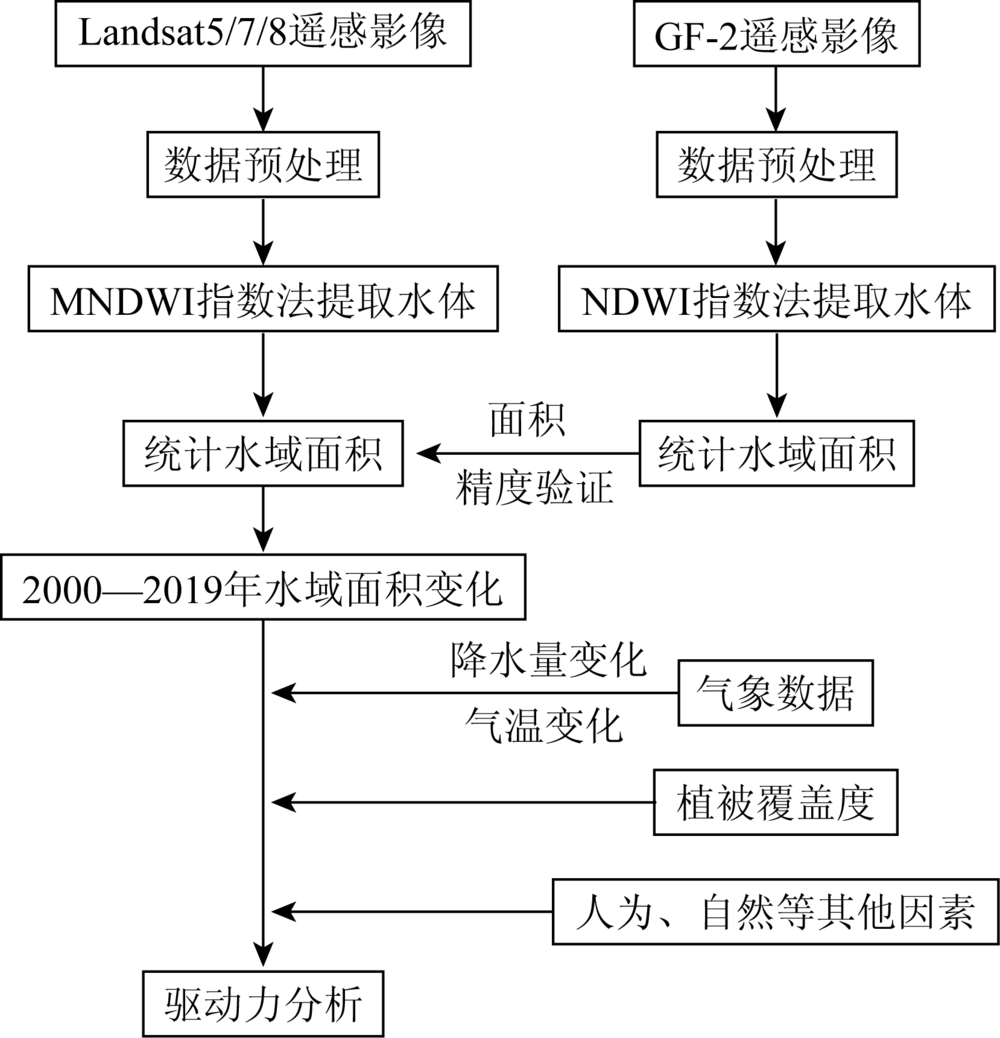
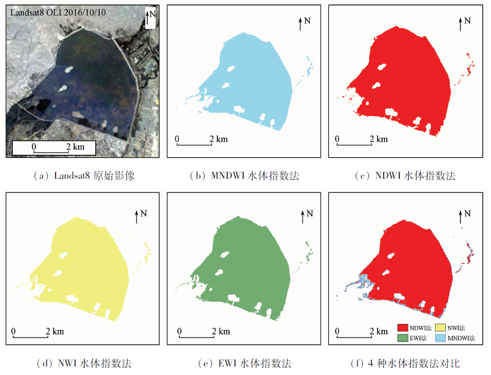
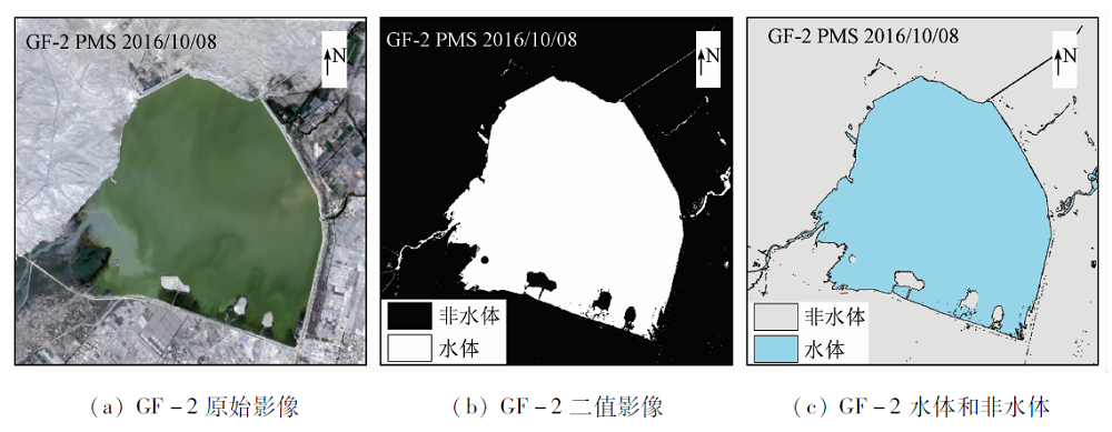
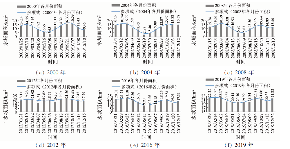
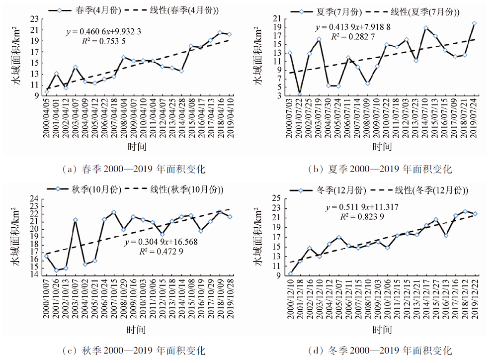
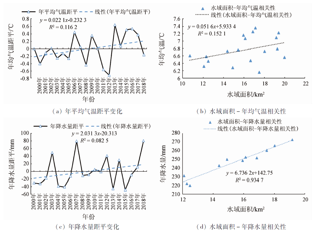
Abstract Hongyashan Reservoir is located in northwestern China where water resources are lacking. Reservoirs are an important support for the ecosystem in this region. Analyzing the changes in the area of the reservoir can effectively help Minqin County Government to make overall plans for water ecological protection and restoration as well as rational use of water resources and can also provide support for its decision-making. Through the extraction and analysis of the water area and vegetation coverage of the Landsat series data and GF-2 data from 2000 to 2019 and in combination with the surrounding meteorological data and the collection of local data, the authors comprehensively analyzed the influencing factors of the water area change and explored the spatial and temporal changes of the water area as well as the driving force. The results show that, on the whole, the water area of Hongyashan Reservoir has continued to increase in the past 20 years, the total area has increased by 8.98 km2, and the area change rate is as high as 42.6%, and that, in terms of monthly changes, the change in water area has an inverted “normal distribution” curve. The trend is that the wet season is mainly concentrated in March and September-October in the spring and autumn seasons, and the dry season is mainly concentrated in June in the summer. In terms of interannual variability, the water area is greatly affected by the seasons, so it is divided into spring, summer, autumn and winter. Interannual analysis shows that the water area in spring and winter continues to rise, with average annual growth rates of 5.03% and 5.22%, the lowest average annual growth rate in autumn is only 2.42%, and the average annual growth rate of summer water area is 22.19%, which is the season with the largest variation amplitude, exhibiting “V” fluctuation and rising. According to the meteorological data such as temperature, precipitation and evaporation, the correlation analysis of vegetation coverage and water area, and the analysis of related hydrological data, the following conclusions can be drawn: the direct driving forces are the change in precipitation, the increasing project expansion, and the change of runoff into the reservoir, whereas the indirect driving forces include changes in temperature, changes in vegetation coverage, the industrial, agricultural and domestic water use, and the restoration of the ecological environment.
|
| Keywords
Hongyashan Reservoir
remote sensing survey
water area
driving force
|
|
|
|
Corresponding Authors:
GAN Fuping
E-mail: haoguzhuang@126.com;fpgan@aliyun.com
|
|
Issue Date: 21 July 2021
|
|
|
| [1] |
吴川, 张玉龙, 许秀贞, 等. 基于Landsat TM/ETM和HJ-1A/B影像的丹江口水库水域变化监测研究[J]. 长江流域资源与环境, 2013, 22(9):1207-1213.
|
| [1] |
Wu C, Zhang Y L, Xu X Z, et al. Research on water monitoring of Danjiangkou Reservoir based on Landsat TM/ETM and HJ-1A/B images[J]. Resources and Environment of the Yangtze River Basin, 2013, 22(9):1207-1213.
|
| [2] |
李均力, 胡汝骥, 黄勇, 等. 1964—2014年柴窝堡湖面积的时序变化及驱动因素[J]. 干旱区研究, 2015, 32(3):417-427.
|
| [2] |
Li J L, Hu R J, Huang Y, et al. The time-series changes and driving factors of the area of Chaiwopu Lake from 1964 to 2014[J]. Arid Zone Research, 2015, 32(3):417-427.
|
| [3] |
魏善蓉, 金晓媚, 王凯霖, 等. 基于遥感的柴达木盆地湖泊面积变化与气候响应分析[J]. 地学前缘, 2017, 24(5):427-433.
|
| [3] |
Wei S R, Jin X M, Wang K L, et al. Analysis of lake area changes and climate response in Qaidam Basin based on remote sensing[J]. Earth Science Frontiers, 2017, 24(5):427-433.
|
| [4] |
张文, 崔长露, 李林宜, 等. 基于长时间序列遥感数据的鄱阳湖水面面积监测分析[J]. 水文, 2019, 39(3):29-35,21.
|
| [4] |
Zhang W, Cui C L, Li L Y, et al. Monitoring and analysis of the water surface area of Poyang Lake based on long-term serial remote sensing data[J]. Hydrology, 2019, 39(3):29-35,21.
|
| [5] |
张兆鹏, 李增元, 田昕, 等. 1987—2016年红崖山水库面积时空变化分析[J]. 甘肃农业大学学报, 2018, 53(5):127-135.
|
| [5] |
Zhang Z P, Li Z Y, Tian X, et al. Analysis of the spatial and temporal changes of the area of Hongyashan Reservoir from 1987 to 2016[J]. Journal of Gansu Agricultural University, 2018, 53(5):127-135.
|
| [6] |
刘治国. 红崖山水库水环境变化趋势分析[J]. 甘肃农业, 2007(10):82.
|
| [6] |
Liu Z G. Analysis of water environment change trend of Hongyashan Reservoir[J]. Gansu Agriculture, 2007(10):82.
|
| [7] |
尹亚坤. 红崖山水库灌区水资源评价与承载能力研究[D]. 西安:西安理工大学, 2005.
|
| [7] |
Yin Y K. Research on water resources evaluation and carrying capacity of Hongyashan Reservoir Irrigation District[D]. Xi’an:Xi’an University of Technology, 2005.
|
| [8] |
徐丹蕾, 丁靖南, 伍永秋. 1989—2014年毛乌素沙地湖泊面积[J]. 中国沙漠, 2019, 39(6):40-47.
|
| [8] |
Xu D L, Ding J N, Wu Y Q. Lake area of Maowusu Sandy Land from 1989 to 2014[J]. Chinese Desert, 2019, 39(6):40-47.
|
| [9] |
McFeeters S K. The use of the normalized difference water index (NDWI) in the delineation of open water features[J]. International Journal of Remote Sensing, 1996, 17(7):1425-1432.
doi: 10.1080/01431169608948714
url: https://www.tandfonline.com/doi/full/10.1080/01431169608948714
|
| [10] |
Otsu N. A tlreshold selection method from gray-level histograms[J]. IEEE Transactions on Systems,Man,and Cybernetics, 1979, 9(1):62-66.
doi: 10.1109/TSMC.1979.4310076
url: http://ieeexplore.ieee.org/document/4310076/
|
| [11] |
徐涵秋. 利用改进的归一化差异水体指数(MNDWI)提取水体信息的研究[J]. 遥感学报, 2005(5):589-595.
|
| [11] |
Xu H Q. Research on extracting water body information with improved normalized difference water body index (MNDWI)[J]. Journal of Remote Sensing, 2005(5):589-595.
|
| [12] |
丁凤. 基于新型水体指数(NWI)进行水体信息提取的实验研究[J]. 测绘科学, 2009, 34(4):155-157.
|
| [12] |
Ding F. Experimental research on water body information extraction based on the new water body index (NWI)[J]. Surveying and Mapping Science, 2009, 34(4):155-157.
|
| [13] |
闫霈, 张友静, 张元. 利用增强型水体指数(EWI)和GIS去噪音技术提取半干旱地区水系信息的研究[J]. 遥感信息, 2007(6):62-67.
|
| [13] |
Yan P, Zhang Y J, Zhang Y. Research on extracting water system information in semi-arid area by using enhanced water body index (EWI) and GIS denoising technology[J]. Remote Sensing Information, 2007(6):62-67.
|
| [14] |
郭永强, 王乃江, 褚晓升, 等. 基于Google Earth Engine分析黄土高原植被覆盖变化及原因[J]. 中国环境科学, 2019, 39(11):4804-4811.
|
| [14] |
Guo Y Q, Wang N J, Chu X S, et al. Analysis of changes and causes of vegetation coverage on the Loess Plateau based on Google Earth Engine[J]. Chinese Environmental Science, 2019, 39(11):4804-4811.
|
| [15] |
Bakuła M, Pelc-Mieczkowska R, Walawski M. Reliable and redundant RTK positioning for applications in hard observational conditions[J]. Artificial Satellites, 2012, 47(1).23-33.
doi: 10.2478/v10018-012-011-0
url: https://content.sciendo.com/doi/10.2478/v10018-012-011-0
|
| [16] |
裴杰, 牛铮, 王力, 等. 基于Google Earth Engine云平台的植被覆盖度变化长时间序列遥感监测[J]. 中国岩溶, 2018, 37(4):608-616.
|
| [16] |
Pei J, Niu Z, Wang L, et al. Long-term remote sensing monitoring of vegetation coverage changes based on Google Earth Engine cloud platform[J]. China Karst, 2018, 37(4):608-616.
|
| [17] |
李渊, 张芮, 石岩, 等. 干旱绿洲区水资源规划配置与生态环境修复——以石羊河流域民勤绿洲为例[J]. 水利规划与设计, 2019(1):6-8.
|
| [17] |
Li Y, Zhang R, Shi Y, et al. Water resources planning and ecological environment restoration in arid oasis areas——Taking the Minqin Oasis in the Shiyang River Basin as an example[J]. Water Resources Planning and Design, 2019(1):6-8.
|
| [18] |
李渊. 红崖山水库加高扩建工程土建施工实践[J]. 甘肃科技纵横, 2017, 46(10):49-51,12.
|
| [18] |
Li Y. Practice of civil construction of Hongyashan reservoir heightening and expansion project[J]. Gansu Science and Technology, 2017, 46(10):49-51,12.
|
| [19] |
彭祥荣, 赵明瑞. 民勤县青土湖生态变化调查分析[J]. 现代农业科技, 2019(16):167,170.
|
| [19] |
Peng X R, Zhao M R. Investigation and analysis of ecological changes of Qingtu Lake in Minqin County[J]. Modern Agricultural Science and Technology, 2019(16):167,170.
|
| [20] |
卢生霞. 红崖山水库加高扩建工程石羊河蔡旗断面来水分析计算[J]. 农业科技与信息, 2018(21):99-101.
|
| [20] |
Lu S X. Incoming water analysis and calculation of Cai section of Shiyang River at the heightening and expansion project of Hongyashan Reservoir[J]. Agricultural Science and Technology, 2018(21):99-101.
|
| [21] |
金彦兆, 孙栋元, 胡想全, 等. 石羊河流域红崖山水库站径流变化特征及应对措施[J]. 水利规划与设计, 2018(10):38-40,47.
|
| [21] |
Jin Y Z, Sun D Y, Hu X Q, et al. Runoff variation characteristics and countermeasures of Hongyashan Reservoir station in Shiyang River basin[J]. Water Resources Planning and Design, 2018(10):38-40,47.
|
| [22] |
汪志远. 红沙岗供水工程施测方法初探[J]. 经纬天地, 2018(4):59-61.
|
| [22] |
Wang Z Y. A Preliminary study on the surveying methods of Hongshagang water supply project[J]. Jingwei Tiandi, 2018(4):59-61.
|
|
Viewed |
|
|
|
Full text
|
|
|
|
|
Abstract
|
|
|
|
|
Cited |
|
|
|
|
| |
Shared |
|
|
|
|
| |
Discussed |
|
|
|
|
 2021,
Vol. 33
2021,
Vol. 33