|
|
 |
|

|
|
|
An analysis of land use changes and driving forces of Dajiuhu wetland in Shennongjia based on high resolution remote sensing images: Constraints from the multi-source and long-term remote sensing information |
HU Suliyang1,2,3( ), LI Hui1,2(), GU Yansheng4,5, HUANG Xianyu1,2, ZHANG Zhiqi6, WANG Yingchun6 ), LI Hui1,2(), GU Yansheng4,5, HUANG Xianyu1,2, ZHANG Zhiqi6, WANG Yingchun6 |
1. China University of Geosciences(Wuhan), School of Geography and Information Engineering, Wuhan 430074, China
2. China University of Geosciences(Wuhan),Hubei Key Laboratory of Critical Zone Evolution, Wuhan 430074, China
3. Geological Surveying and Mapping Institute, Kunming 650000, China
4. State Key Laboratory of Biogeology and Environmental Geology, China University of Geosciences, Wuhan 430074, China
5. Hubei Key Laboratory of Wetland Evolution and Eco-Restoration(WEER), China University of Geosciences, Wuhan 430074, China
6. Shennongjia National Park Management Bureau, Shennongjia 442421, China |
|
|
|
|
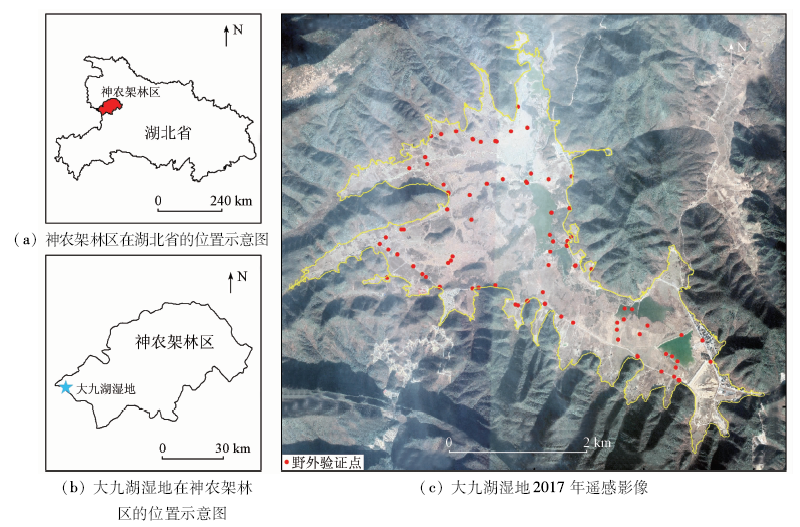
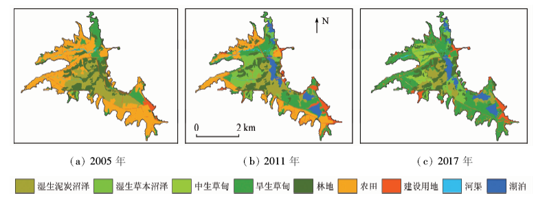
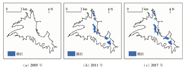
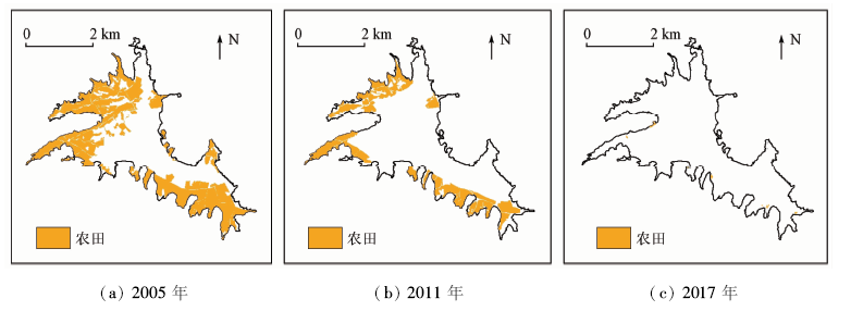
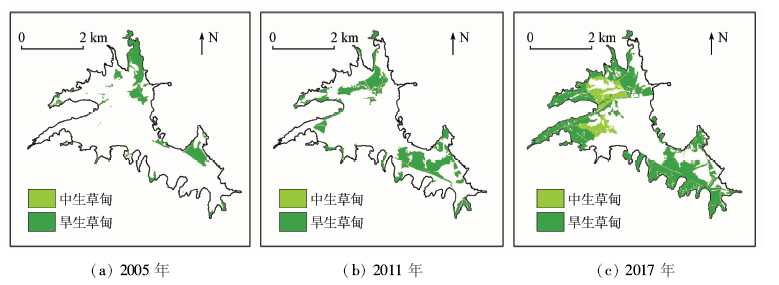
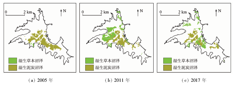
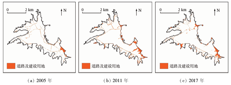
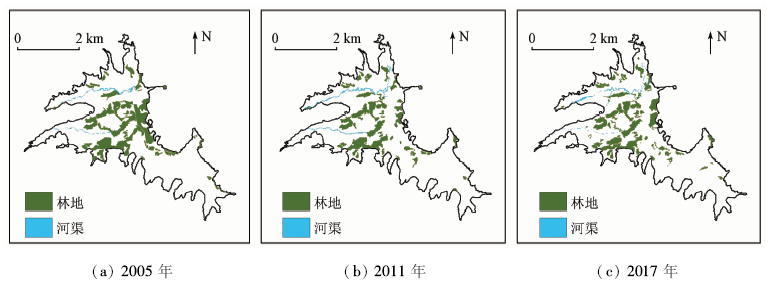
Abstract Dajiu lake wetland is a rare subtropical alpine wetland in Central China. The wetland has experienced several periods of large-scale development since the founding of the People’s Republic of China, which has led to the serious destruction of the wetland. The “Dajiu Lake wetland protection and restoration and park construction project” implemented in 2005 has made the wetland function recovered to a certain extent. To understand the land use changes in Dajiuhu wetland, the authors identified nine land use types of Dajiu lake wetland based on field investigation and previous work. The high-resolution remote sensing images acquired in 2005, 2011 and 2017 and UAV images in 2018 were used to visually interpret the land use types. The dynamic change and type conversion of land use in three periods were examined and the driving forces were explored. The results show that, from 2005 to 2011, new lakes (84.41 hm2) were added, and the most decreased area was farmland, which mainly transformed into xerophytic meadow and wet herbaceous swamp. From 2011 to 2017, a new type of mesophytic meadow (80.07 hm2) was added, which was mainly transformed from wet peat swamp, wet herbaceous swamp and xerophytic meadow. Most of the reduction was in farmland, which was mainly converted to xerophytic meadow. In a word, during the research period, the wetland types and areas of Dajiu Lake were increasing, the wetland landscape was restored to a certain extent, and the wetland ecological environment was improved. The analysis of driving forces shows that the establishment of Wetland Nature Reserve and a series of effective wetland ecological restoration projects are the main driving forces of land use change in Dajiu Lake wetland. The results of this study can provide reference and suggestions for wetland restoration and protection.
|
| Keywords
Shennongjia Dajiu Lake
high resolution remote sensing image
land use
wetland
driving forces
|
|
|
| Fund:CUGCJ1806 |
|
Corresponding Authors:
LI Hui
E-mail: jacobxiaosu@foxmail.com;leelmars@gmail.com
|
|
Issue Date: 18 March 2021
|
|
|
| [1] |
Liu W, Guo Z, Jiang B, et al. Improving wetland ecosystem health in China[J]. Ecological Indicators, 2020,113:106184.
|
| [2] |
Meng W, He M, Hu B, et al. Status of wetlands in China:A review of extent,degradation,issues and recommendations for improvement[J]. Ocean & Coastal Management, 2017,146:50-59.
|
| [3] |
黄咸雨, 张志麒, 王红梅, 等. 神农架大九湖泥炭湿地关键带监测进展[J]. 地球科学, 2017,42(6):1026-1038.
|
| [3] |
Huang X Y, Zhang Z Q, Wang H M, et al. Overview on critical zone observatory at Dajiuhu Peatland,Shennongjia[J]. Earth Science, 2017,42(6):1026-1038.
|
| [4] |
杜培军, 陈宇, 谭琨. 江苏滨海湿地土地利用/覆盖变化与地表温度响应遥感监测[J]. 国土资源遥感, 2014,26(2):112-120.doi: 10.6046/gtzyyg.2014.02.19.
|
| [4] |
Du P J, Chen Y, Tan K. The remote sensing monitoring of land use/cover change and land surface temperature responses over the coastal wetland in Jiangsu[J]. Remote Sensing for Land and Resources, 2014,26(2):112-120.doi: 10.6046/gtzyyg.2014.02.19.
|
| [5] |
张登荣, 许思莹, 谢斌, 等. 近40年椒江—台州湾滩涂围垦土地利用变化的遥感调查[J]. 国土资源遥感, 2016,28(1):101-106.doi: 10.6046/gtzyyg.2016.01.15.
|
| [5] |
Zhang D R, Xu S Y, Xie B, et al. Land use change of reclaimed mud flats in Jiaojiang-Taizhou Estuary in the past 40 years based on remote sensing technology[J]. Remote Sensing for Land and Resources, 2016,28(1):101-106.doi: 10.6046/gtzyyg.2016.01.15.
|
| [6] |
尹发能, 王学雷, 余璟. 大九湖土地利用变化及其对湿地生态环境的影响研究[J]. 华中师范大学学报(自然科学版), 2007(1):148-151.
|
| [6] |
Yin F N, Wang X L, Yu J. A study on landuse change of the Dajiu Lake and the impact on wetland ecological environment[J]. Journal of Huazhong Normal University(Nat.Sci.), 2007(1):148-151.
|
| [7] |
余璟, 王学雷, 吴宜进, 等. 神农架大九湖景观格局变化与湿地生态恢复对策[J]. 华中农业大学学报, 2008(1):122-126.
|
| [7] |
Yu J, Wang X L, Wu Y J, et al. Changes of Shennongjia Dajiuhu landscape pattern and the strategies of wetland ecological restoration[J]. Journal of Huazhong Agricultural University, 2008(1):122-126.
|
| [8] |
姜刘志, 王学雷, 厉恩华, 等. 生态恢复前后神农架大九湖湿地土地利用变化研究[J]. 华中师范大学学报(自然科学版), 2013,47(2):282-286.
|
| [8] |
Jiang L Z, Wang X L, Li E H, et al. A study on the land use change of Dajiuhu wetland in mt.Shennongjia in response to ecological restoration[J]. Journal of Huazhong Normal University(Nat. Sci.), 2013,47(2):282-286.
|
| [9] |
杜耘, 蔡述明, 王学雷, 等. 神农架大九湖亚高山湿地环境背景与生态恢复[J]. 长江流域资源与环境, 2008(6):915-919.
|
| [9] |
Du Y, Cai S M, Wang X L, et al. Environmental Background and Ecological Restoration of the Dajiuhu Sub-alpine Wetland in Mt.Shennongjia[J]. Resources and Environment in the Yangtze Basin, 2008(6):915-919.
|
| [10] |
伦子健, 顾延生, 刘红叶, 等. 神农架大九湖湿地表土植硅体记录及其环境意义[J]. 第四纪研究, 2016,36(3):656-665.
|
| [10] |
Lun Z J, Gu Y S, Liu H Y, et al. Phytolith records in the surface soils of Dajiuhu Wetland and their environmental significance[J]. Quaternary Sciences, 2016,36(3):656-665.
|
| [11] |
石敏, 喻建新, 顾延生, 等. 神农架大九湖晚更新世与全新世之交的气候变化——来自孢粉的信息[J]. 地质科技情报, 2008(6):24-28.
|
| [11] |
Shi M, Yu J X, Gu Y S, et al. Climate changes in interim of late Pleistocene and Holocene in Dajiuhu basin of Shennongjia,Hubei Province:Evidence from pollen[J]. Geological Science and Technology Information, 2008(6):24-28.
|
| [12] |
湖北省神农架林区地方志编纂委员会. 神农架志[M]. 武汉: 湖北科学技术出版社, 1996.
|
| [12] |
Shennongjia Forest District Chronicles Compilation Committee of Hubei Province. Shennongjia chronicles[M]. Wuhan: Hubei Science and Technology Press, 1996.
|
| [13] |
罗涛, 伦子健, 顾延生, 等. 神农架大九湖湿地植物群落调查与生态保护研究[J]. 湿地科学, 2015,13(2):153-160.
|
| [13] |
Luo T, Lun Z J, Gu Y S, et al. Plant community survey and ecological protection of Dajiuhu wetlands in Shennongjia area[J]. Wetland Science, 2015,13(2):153-160.
|
| [14] |
桑潇, 国巧真, 潘应阳, 等. 基于TM和OLI数据山西省潞城市土地利用动态变化分析与预测[J]. 国土资源遥感, 2018,30(2):125-131.doi: 10.6046/gtzyyg.2018.02.17.
|
| [14] |
Sang X, Guo Q Z, Pan Y Y, et al. Research on land use dynamic change and prediction in Lucheng City of Shanxi Province based on TM and OLI[J]. Remote Sensing for Land and Resources, 2018,30(2):125-131.doi: 10.6046/gtzyyg.2018.02.17.
|
| [15] |
李石华, 周峻松, 王金亮. 1974—2014年抚仙湖流域土地利用/覆盖时空变化与驱动力分析[J]. 国土资源遥感, 2017,29(4):132-139.doi: 10.6046/gtzyyg.2017.04.20.
|
| [15] |
Li S H, Zhou J S, Wang J L. Spatio-temporal LUCC and driving force in Fuxian Lake watershed from 1974 to 2014[J]. Remote Sensing for Land and Resources, 2017,29(4):132-139.doi: 10.6046/gtzyyg.2017.04.20.
|
| [16] |
李辉, 张利华, 陈晓玲. 基于GIS/RS的鄱阳湖区土地利用变化及空间分异特征研究[J]. 华中师范大学学报(自然科学版), 2009,43(4):666-671.
|
| [16] |
Li H, Zhang L H, Chen X L. Land use change and spatial distribution characteristics based on RS and GIS in Poyang Lake area[J]. Journal of Huazhong Normal University(Nat. Sci.), 2009,43(4):666-671.
|
|
Viewed |
|
|
|
Full text
|
|
|
|
|
Abstract
|
|
|
|
|
Cited |
|
|
|
|
| |
Shared |
|
|
|
|
| |
Discussed |
|
|
|
|
 2021,
Vol. 33
2021,
Vol. 33