|
|
|
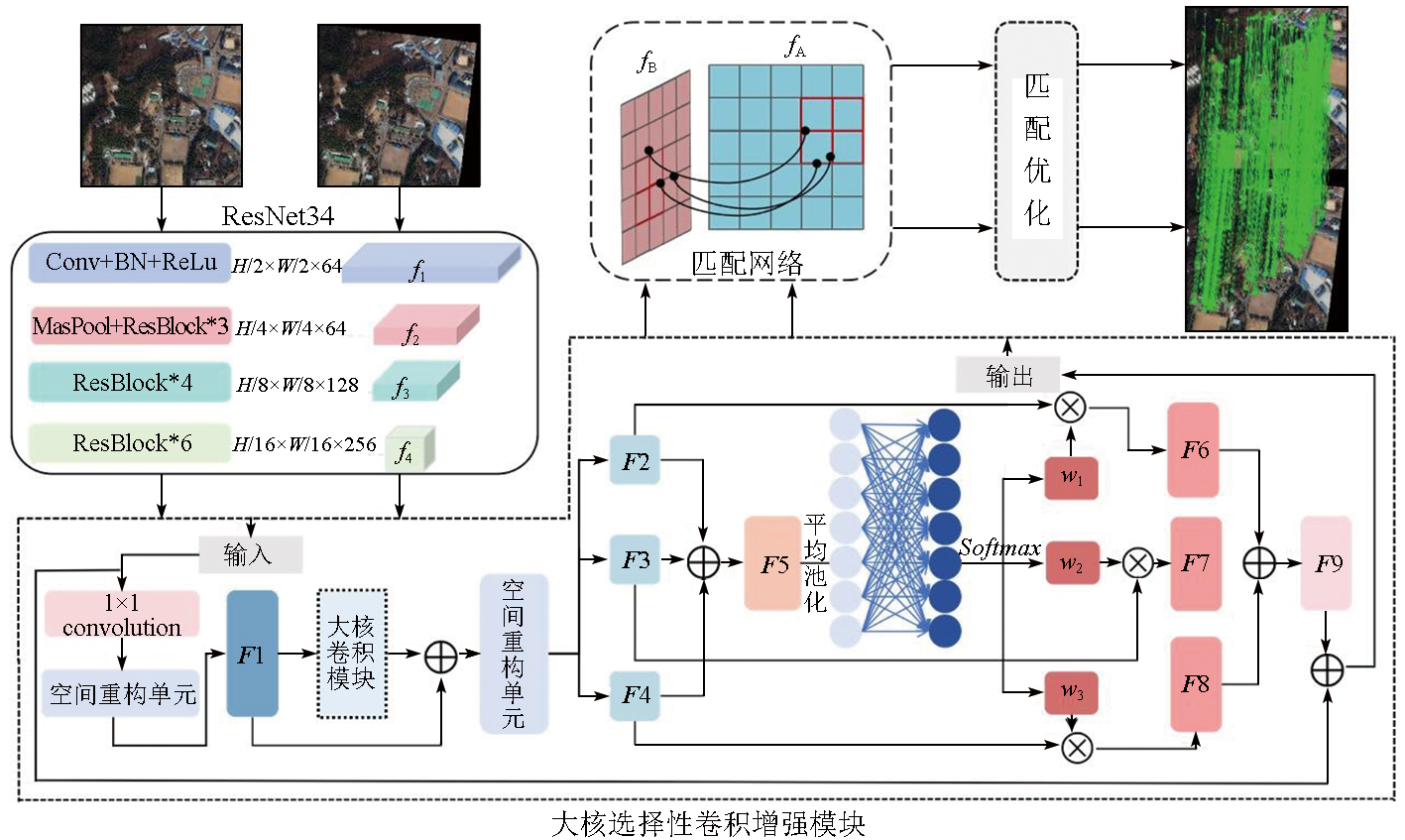
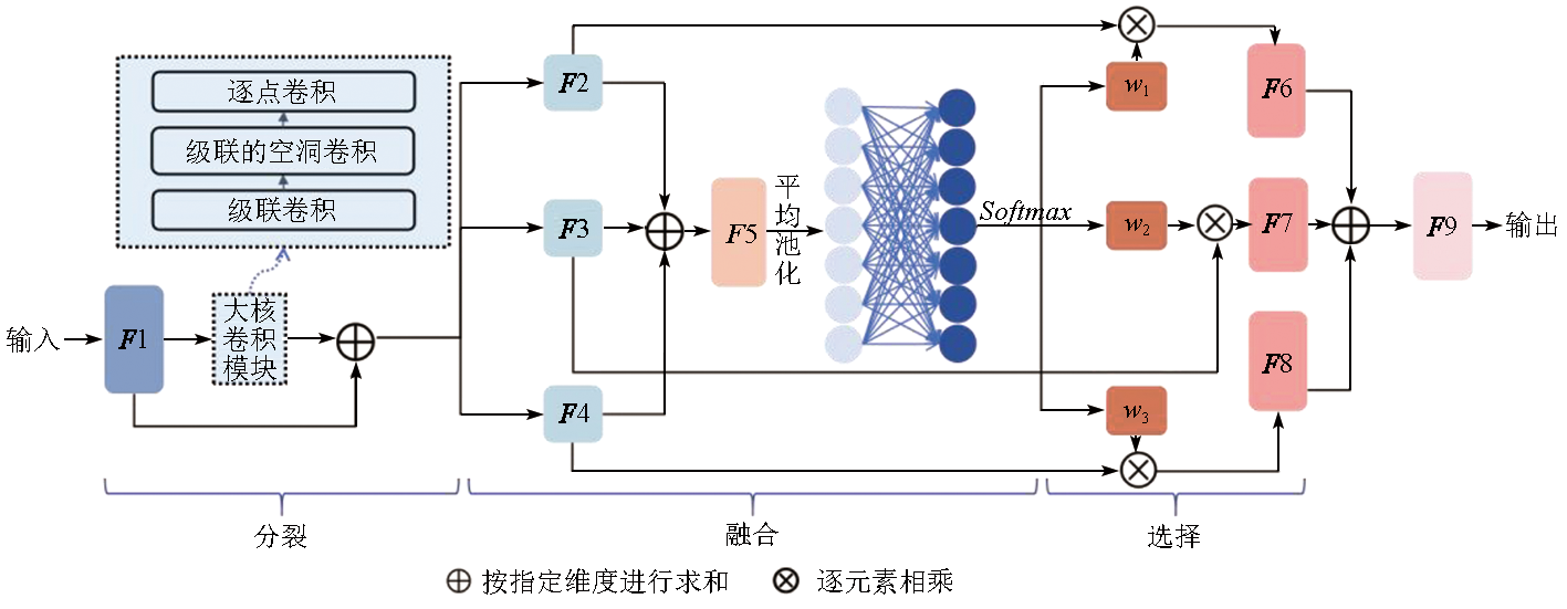
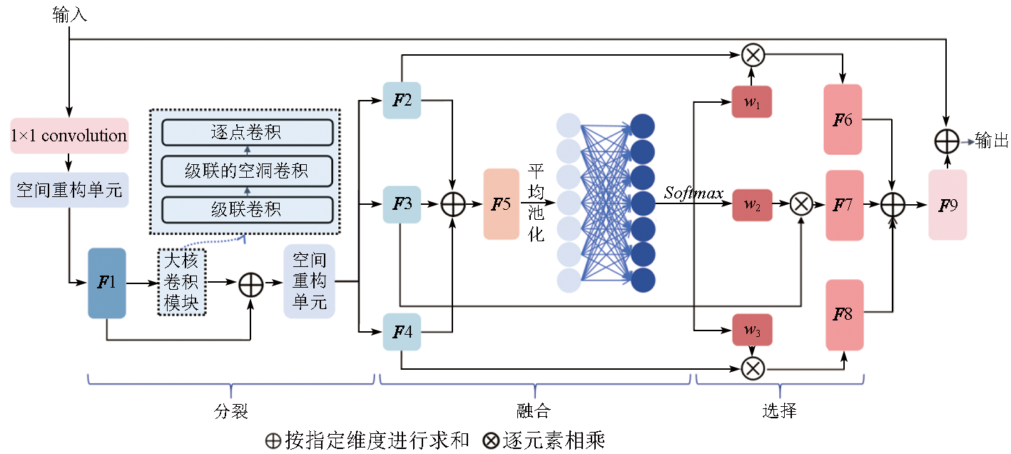
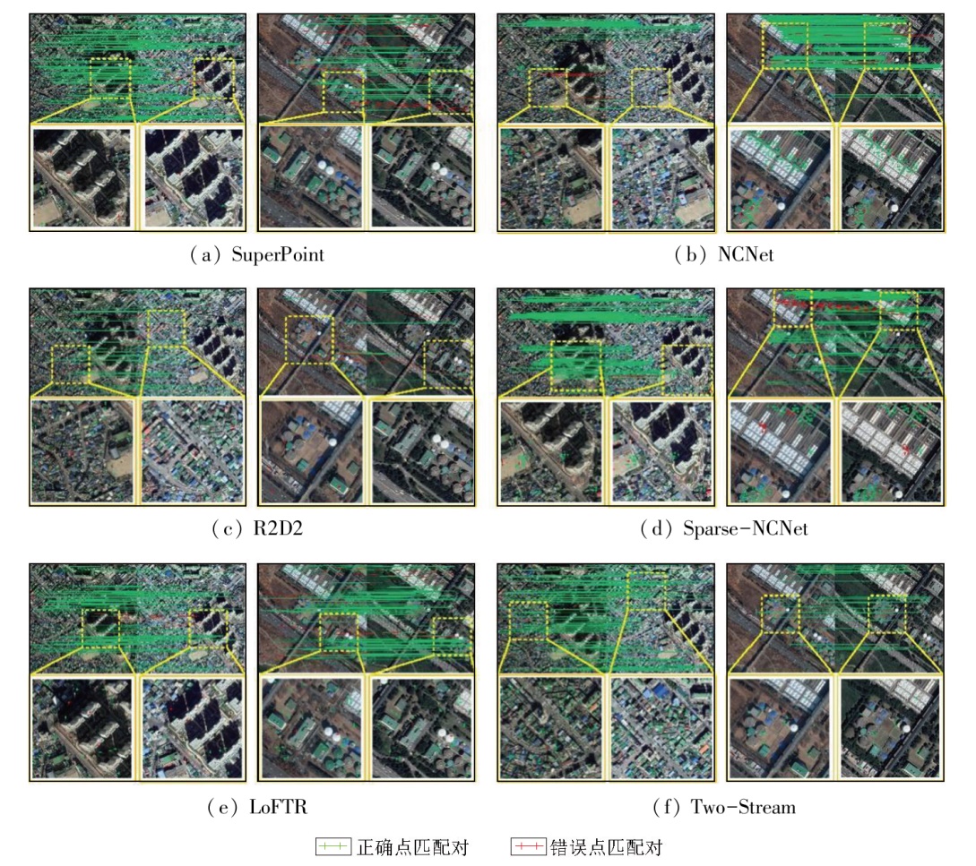
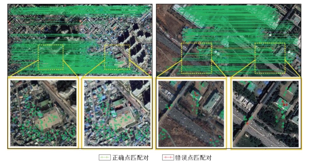
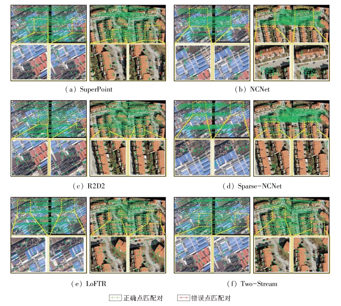
Abstract Extracting information on various surface features from remote sensing images requires varying contextual data. To address this issue, this study proposed a new feature point matching method that integrated a large selective kernel-enhanced convolutional module. In this method, based on the ResNet34 network, a large selective kernel-enhanced convolutional module was embedded for dynamic feature extraction of different surface feature targets. Then, the initial dense matching was obtained using a sparse neighborhood consensus network. Meanwhile, geometric and motion consistency constraints were introduced to conduct the guided diffusion of matching points. Consequently, optimized matching results were achieved. This method yielded a PCK (α=0.05) accuracy of 0.89 on the Google Earth dataset, which increased by 7.22%, 5.95%, 2.30%, 4.71%, 7.22%, and 9.88%, respectively, compared to the SuperPoint, R2D2, NCNet, Sparse-NCNet, LoFTR, and Two-Stream networks. Additionally, it exhibited a high generalization ability on the Hpatches dataset. These results corroborate the effectiveness of the proposed method.
|
| Keywords
feature point matching
large selective kernel-enhanced convolutional structure
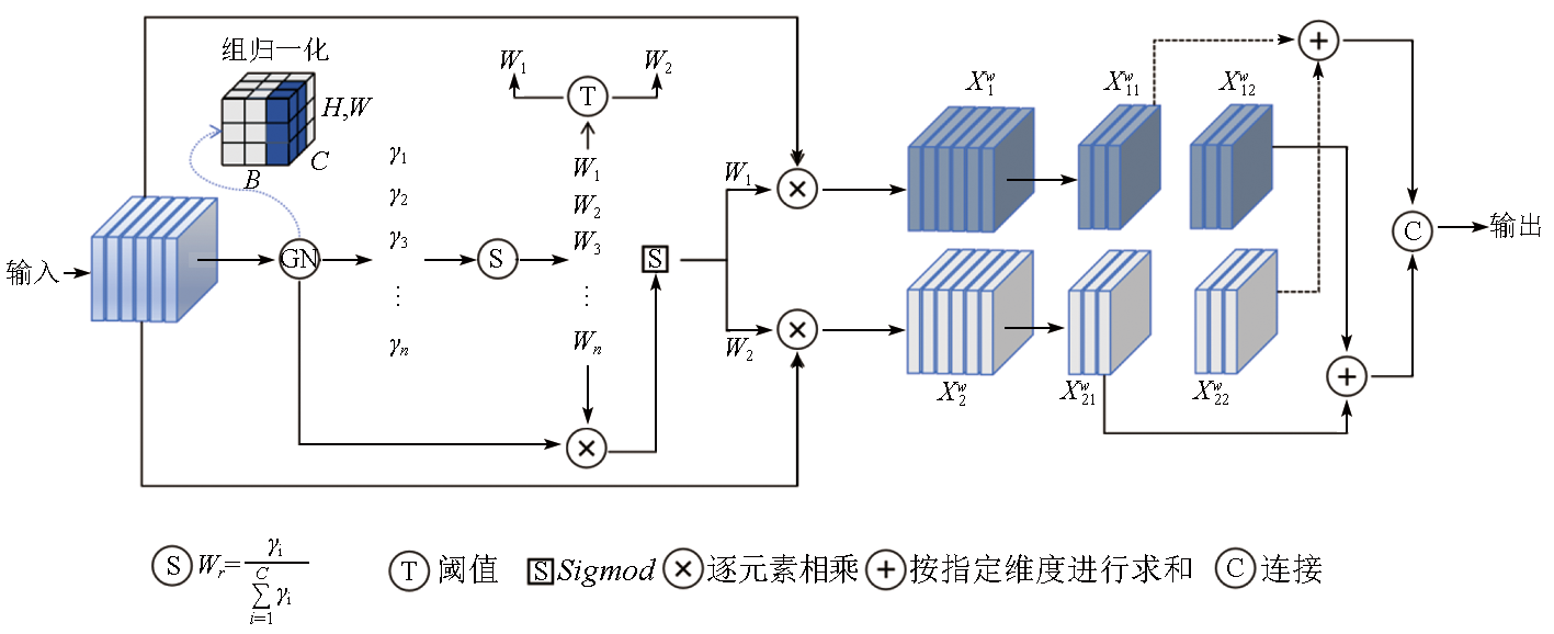
spatial reconstruction
geometric consistency
motion consistency
|
|
|
|
Issue Date: 31 December 2025
|
|
|
| [1] |
Girard N, Charpiat G, Tarabalka Y. Aligning and updating cadaster maps with aerial images by multi-task,multi-resolution deep learning[C]// Computer Vision - ACCV 2018. Cham: Springer International Publishing, 2019:675-690.
|
| [2] |
薛白, 王懿哲, 刘书含, 等. 基于孪生注意力网络的高分辨率遥感影像变化检测[J]. 自然资源遥感, 2022, 34(1):61-66.doi:10.6046/zrzyyg.2021122.
|
| [2] |
Xue B, Wang Y Z, Liu S H, et al. Change detection of high-resolution remote sensing images based on Siamese network[J]. Remote Sensing for Natural Resources, 2022, 34(1):61-66.doi:10.6046/zrzyyg.2021122.
|
| [3] |
Seo S, Choi J S, Lee J, et al. UPSNet:Unsupervised pan-sharpening network with registration learning between panchromatic and multi-spectral images[J]. IEEE Access, 2020,8:201199-201217.
|
| [4] |
Li X, Feng R, Guan X, et al. Remote sensing image mosaicking:Achievements and challenges[J]. IEEE Geoscience and Remote Sensing Magazine, 2019, 7(4):8-22.
|
| [5] |
李星华, 艾文浩, 冯蕊涛, 等. 遥感影像深度学习配准方法综述[J]. 遥感学报, 2023, 27(2):267-284.
|
| [5] |
Li X H, Ai W H, Feng R T, et al. Survey of remote sensing image registration based on deep learning[J]. National Remote Sensing Bulletin, 2023, 27(2):267-284.
doi: 10.11834/jrs.20235012
url: http://www.ygxb.ac.cn/zh/article/doi/10.11834/jrs.20235012/
|
| [6] |
DeTone D, Malisiewicz T, Rabinovich A. SuperPoint:Self-supervised interest point detection and description[C]// 2018 IEEE/CVF Conference on Computer Vision and Pattern Recognition Workshops (CVPRW).June 18-22,2018,Salt Lake City,UT,USA.IEEE,2018:337-33712.
|
| [7] |
Laguna A B, Riba E, Ponsa D, et al. Key.Net:Keypoint detection by handcrafted and learned CNN filters[C]// 2019 IEEE/CVF International Conference on Computer Vision (ICCV).October 27-November 2,2019.Seoul,Korea.IEEE,2019:5835-5843.
|
| [8] |
Simonyan K, Zisserman A. Very deep convolutional networks for large-scale image recognition[EB/OL]. 2014:1409.1556.https://arxiv.org/abs/1409.1556v6.
url: https://arxiv.org/abs/1409.1556v6
|
| [9] |
Yang Z, Dan T, Yang Y. Multi-temporal remote sensing image registration using deep convolutional features[J]. IEEE Access, 2018,6:38544-38555.
|
| [10] |
Revaud J, De Souza C, Humenberger M, et al. R2d2:Reliable and repeatable detector and descriptor[J]. Advances in neural information processing systems, 2019,32.
|
| [11] |
Rocco I, Cimpoi M, Arandjelović R, et al. Neighbourhood consensus networks[C]// Proceedings of the 32nd International Conference on Neural Information Processing Systems.December 3 - 8,2018,Montréal,Canada.ACM, 2018:1658-1669.
|
| [12] |
Li X, Han K, Li S, et al. Dual-resolution correspondence networks[C]// Proceedings of the 34th International Conference on Neural Information Processing Systems.December 6 - 12,2020,Vancouver,BC,Canada.ACM, 2020:17346-17357.
|
| [13] |
Rocco I, Arandjelović R, Sivic J, et al. Efficient neighbourhood consensus networks via submanifold sparse convolutions[C]// Computer Vision - ECCV 2020. ACM, 2020:605-621.
|
| [14] |
陈颖, 张祺, 李文举, 等. 参数合成空间变换网络的遥感图像一致性配准[J]. 中国图象图形学报, 2021, 26(12):2964-2980.
|
| [14] |
Chen Y, Zhang Q, Li W J, et al. Consistent registration of remote sensing images in parametric synthesized spatial transformation network[J]. Journal of Image and Graphics, 2021, 26(12):2964-2980.
doi: 10.11834/jig.200587
url: http://www.cjig.cn/zh/article/doi/10.11834/jig.200587/
|
| [15] |
Vaswani A, Shazeer N, Parmar N, et al. Attention is all you need[J]. Advances in neural information processing systems, 2017,30.
|
| [16] |
Sun J, Shen Z, Wang Y, et al. LoFTR:Detector-free local feature matching with transformers[C]// 2021 IEEE/CVF Conference on Computer Vision and Pattern Recognition (CVPR).June 20-25,2021,Nashville,TN,USA.IEEE, 2021:8918-8927.
|
| [17] |
Guo M H, Lu C Z, Liu Z N, et al. Visual attention network[J]. Computational Visual Media, 2023, 9(4):733-752.
doi: 10.1007/s41095-023-0364-2
url: https://ieeexplore.ieee.org/document/10897730/
|
| [18] |
Lau K W, Po L M, Rehman Y A U. Large separable kernel attention:Rethinking the large kernel attention design in CNN[J]. Expert Systems with Applications, 2024,236:121352.
|
| [19] |
Li X, Wang W, Hu X, et al. Selective kernel networks[C]// 2019 IEEE/CVF Conference on Computer Vision and Pattern Recognition (CVPR).June 15-20,2019. Long Beach,CA,USA.IEEE, 2019:510-519.
|
| [20] |
Li J, Wen Y, He L. SCConv:Spatial and channel reconstruction convolution for feature redundancy[C]// 2023 IEEE/CVF Conference on Computer Vision and Pattern Recognition (CVPR).June 17-24,2023,Vancouver,BC,Canada.IEEE,2023:6153-6162.
|
| [21] |
Park J H, Nam W J, Lee S W. A two-stream symmetric network with bidirectional ensemble for aerial image matching[J]. Remote Sensing, 2020, 12(3):465.
doi: 10.3390/rs12030465
url: https://www.mdpi.com/2072-4292/12/3/465
|
| [22] |
Dai D, Yang W. Satellite image classification via two-layer sparse coding with biased image representation[J]. IEEE Geoscience and Remote Sensing Letters, 2011, 8(1):173-176.
doi: 10.1109/LGRS.2010.2055033
url: http://ieeexplore.ieee.org/document/5545358/
|
| [23] |
Balntas V, Lenc K, Vedaldi A, et al. HPatches:A benchmark and evaluation of handcrafted and learned local descriptors[C]// 2017 IEEE Conference on Computer Vision and Pattern Recognition (CVPR).July 21-26,2017,Honolulu,HI,USA.IEEE,2017:3852-3861.
|
|
Viewed |
|
|
|
Full text
|
|
|
|
|
Abstract
|
|
|
|
|
Cited |
|
|
|
|
| |
Shared |
|
|
|
|
| |
Discussed |
|
|
|
|
 2025,
Vol. 37
2025,
Vol. 37
 ), LI Jiatian(