|
|
|
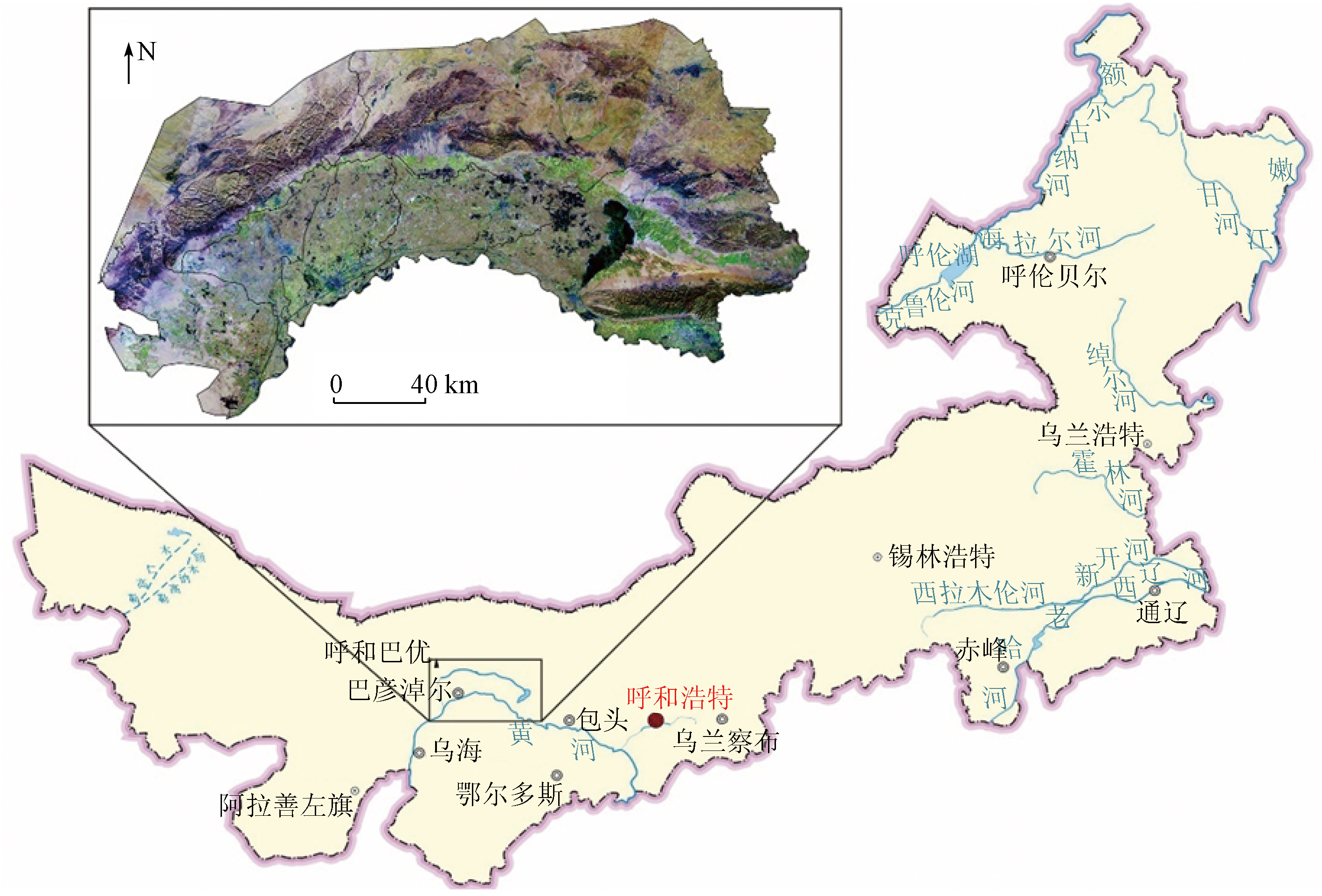
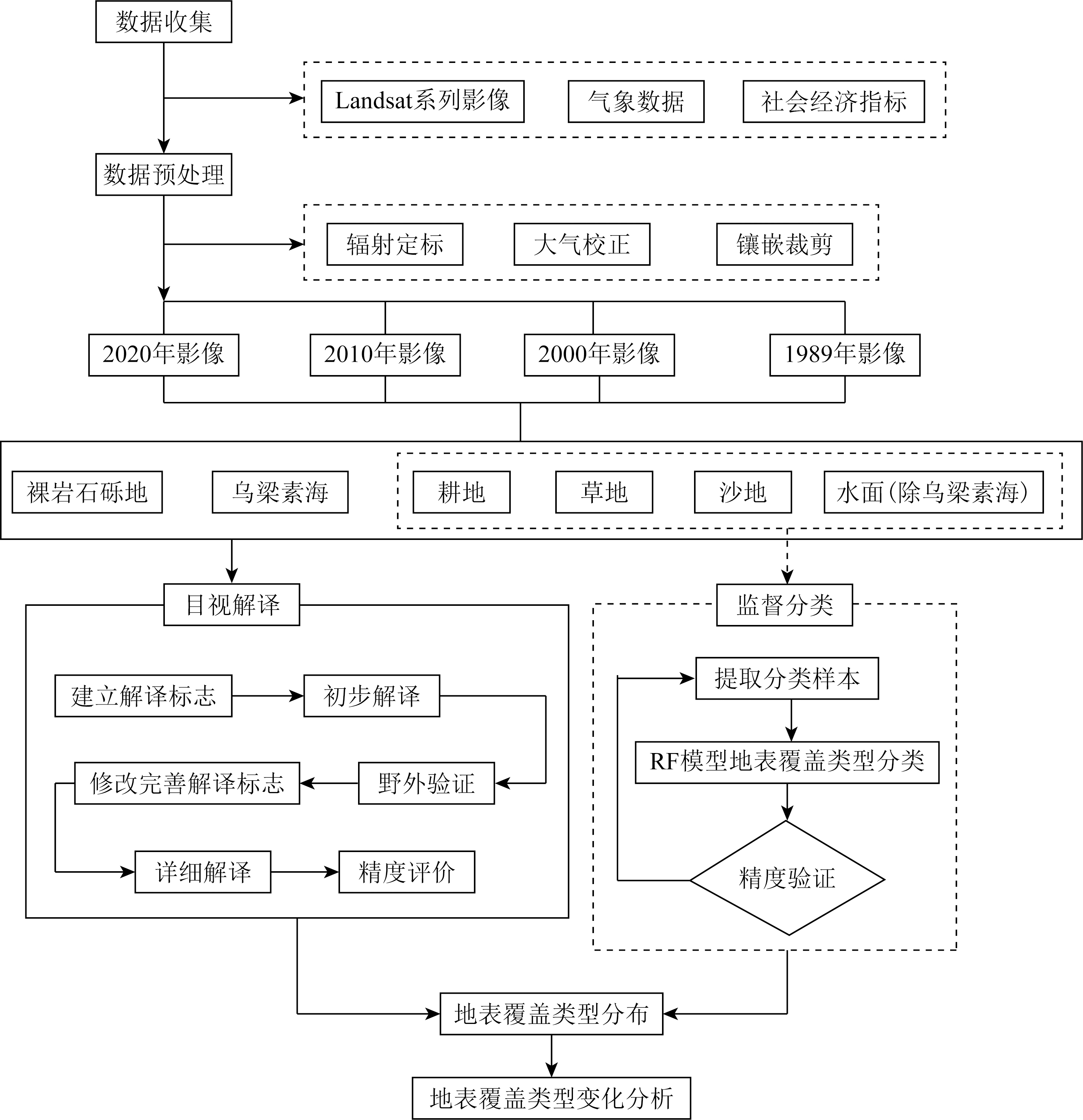
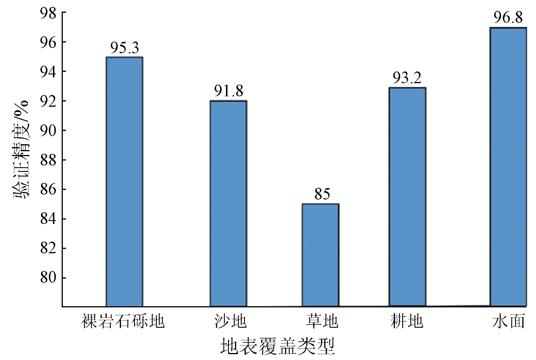
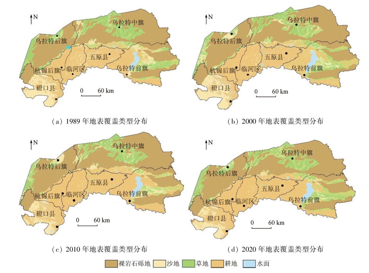
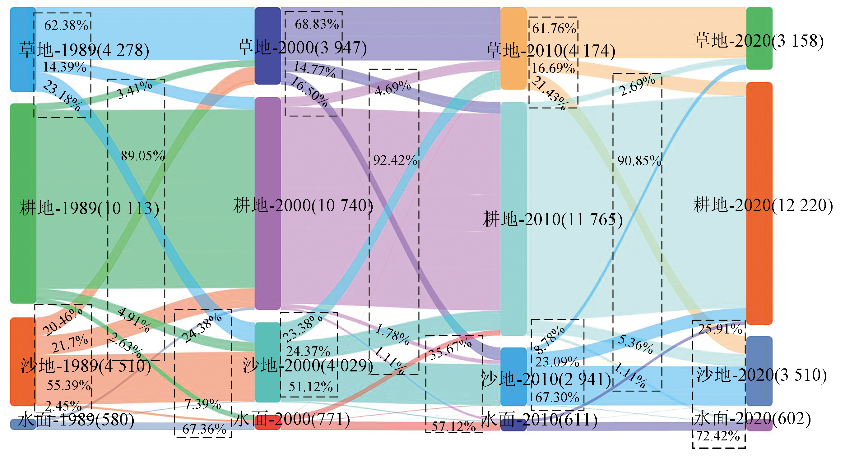
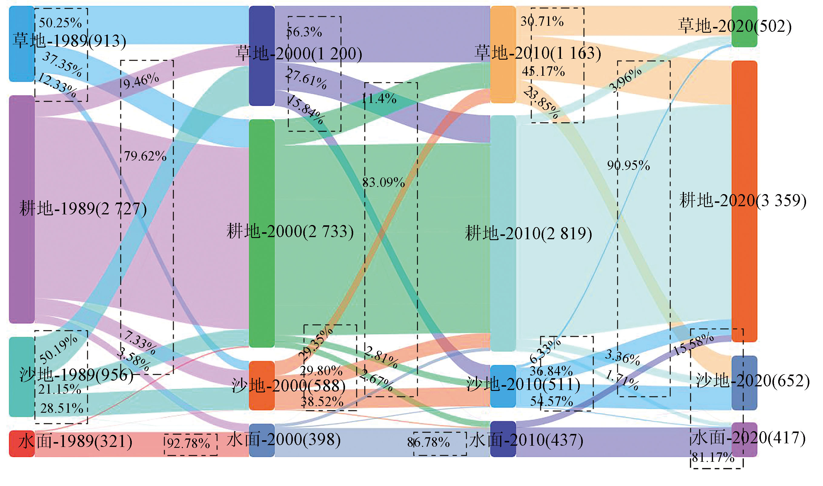
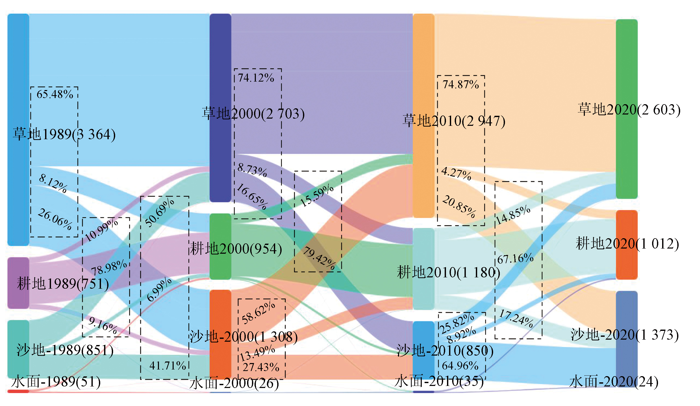
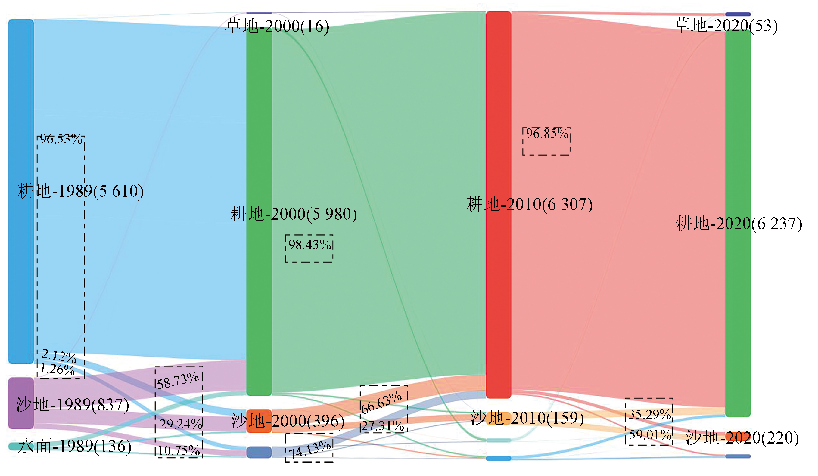
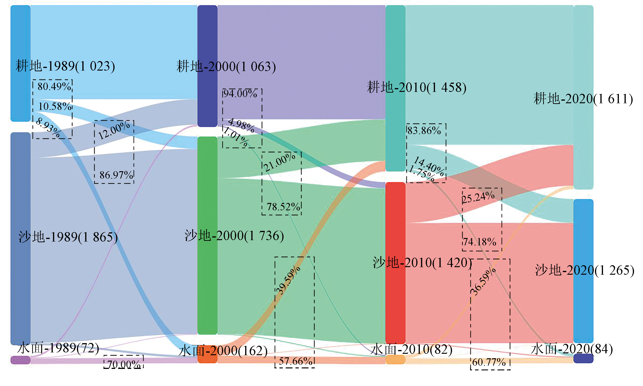
Abstract Changes in land cover types play a significant role in investigating the changes in regional ecological environments. This study aims to accurately determine the changes in land cover types in the Bayannur section of the Yellow River basin from 1989 to 2020. Based on Landsat data images, and combining visual interpretation with supervised random forest classification, this study interpreted and classified the land cover types of banners/counties within the Bayannur section at an average interval of 10 years from 1989 to 2020. The accuracy verification reveals an overall classification accuracy of above 85% and a Kappa coefficient of above 0.80. As demonstrated by the transfer change matrix of land cover types, the Bayannur section during the study period saw a decrease of 22.17% in sandy land, a reduction of 26.18% in grassland, an increase of 20.83% in cultivated land, and subtle variations in water surfaces. Different areas exhibited distinct changes in land cover types. Desert steppe areas were characterized by mutual transformation between sandy land and grassland. Cultivated and sandy land areas primarily exhibited a shift from sandy land to cultivated land, significantly represented by Dengkou County, where the sandy land decreased by 32.17% and the cultivated land increased by 57.48% in 2020 compared to 1989. Changes in land cover types of desert steppe areas were driven by both social and natural factors, whereas those of cultivated and sandy land areas were predominantly subjected to social factors. The results of this study will provide effective data reference and support for more rational planning and utilization of land space.
|
| Keywords
land cover type
supervised classification
random forest
|
|
|
|
Issue Date: 14 June 2024
|
|
|
| [1] |
刘永新, 姜琦刚, 刘伟, 等. 利用GRSFAI预测内蒙古北部干旱地区浅层地下水分布[J]. 世界地质, 2019, 38(4):1142-1151.
|
| [1] |
Liu Y X, Jiang Q G, Liu W, et al. Prediction of shallow groundwater distribution in arid region of northern Inner Mongolia using GRSFAI[J]. Global Geology, 2019, 38(4):1142-1151.
|
| [2] |
Pedruzzi R, Andreão W L, Baek B H, et al. Update of land use/land cover and soil texture for Brazil:Impact on WRF modeling results over São Paulo[J]. Atmospheric Environment, 2022, 268:118760.
|
| [3] |
Cho M S, Qi J. Quantifying spatiotemporal impacts of hydro-dams on land use/land cover changes in the Lower Mekong River Basin[J]. Applied Geography, 2021, 136:102588.
|
| [4] |
Rodriguez-Caballero E, Reyes A, Kratz A, et al. Effects of climate change and land use intensification on regional biological soil crust cover and composition in southern Africa[J]. Geoderma, 2022, 406:115508.
|
| [5] |
高宇婷, 于洋, 孙凌霄, 等. 塔里木盆地南缘绿洲土地覆盖变化及驱动力[J]. 干旱区研究, 2021, 38(4):1172-1183.
|
| [5] |
Gao Y T, Yu Y, Sun L X, et al. Land coverage change and driving forces of an oasis in the southern margin of Tarim Basin[J]. Arid Zone Research, 2021, 38(4):1172-1183.
|
| [6] |
贾丹阳, 熊祯祯, 高岩, 等. 近30 a台特玛湖地区土地利用/土地覆被变化及其影响因素[J]. 干旱区地理, 2021, 44(4):1022-1031.
|
| [6] |
Jia D Y, Xiong Z Z, Gao Y, et al. Land use/Land cover change and influencing factors in the TaiTema Lake in the past 30 years[J]. Arid Land Geography, 2021, 44(4):1022-1031.
|
| [7] |
李石华, 周峻松, 王金亮. 1974—2014年抚仙湖流域土地利用/覆盖时空变化与驱动力分析[J]. 国土资源遥感, 2017, 29(4):132-139.doi:10.6046/gtzyyg.2017.04.20.
|
| [7] |
Li S H, Zhou J S, Wang J L. Spatio-temporal LUCC and driving force in Fuxian Lake watershed from 1974 to 2014[J]. Remote Sensing for Land Resources, 2017, 29(4):132-139.doi:10.6046/gtzyyg.2017.04.20.
|
| [8] |
黄鹏程, 张明明, 王新宇, 等. 基于Landsat8 OLI的西安市土地利用类型遥感分类研究[J]. 测绘与空间地理信息, 2020, 43(1):85-88,92.
|
| [8] |
Huang P C, Zhang M M, Wang X Y, et al. Remote sensing classification of land use in Xi’an based on Landsat8 OLI[J]. Geomatics & Spatial Information Technology, 2020, 43(1):85-88,92.
|
| [9] |
宋奇, 冯春晖, 高琪, 等. 阿拉尔垦区近30年耕地变化及其驱动因子分析[J]. 国土资源遥感, 2021, 33(2):202-212.doi:10.6046/gtzyyg.2020183.
|
| [9] |
Song Q, Feng C H, Gao Q, et al. Change of cultivated land and its driving factors in Alar reclamation area in the past thirty years[J]. Remote Sensing for Land Resources, 2021, 33(2):202-212.doi: 10.6046/gtzyyg.2020183.
|
| [10] |
王敏, 高新华, 陈思宇, 等. 基于Landsat8遥感影像的土地利用分类研究——以四川省红原县安曲示范区为例[J]. 草业科学, 2015, 32(5):694-701.
|
| [10] |
Wang M, Gao X H, Chen S Y, et al. The land use classification based on Landsat8 remote sensing image:A case study of Anqu demonstration community in Hongyuan County of Sichuan Province[J]. Pratacultural Science, 2015, 32(5):694-701.
|
| [11] |
袁盼丽, 汪传建, 赵庆展, 等. 基于深度学习的寒旱区多时序影像土地利用及变化监测——以新疆莫索湾垦区为例[J]. 干旱区地理, 2021, 44(6):1717-1728.
|
| [11] |
Yuan P L, Wang C J, Zhao Q Z, et al. Dynamic monitoring of land-use/land-cover change in cold and arid region based on deep learning: A case study of Mosuowan reclamation area in Xinjiang[J]. Arid Land Geography, 2021, 44(6):1717-1728.
|
| [12] |
张金良, 王炜, 付健, 等. 黄河流域内流区土地利用与植被覆盖时空演变规律[J]. 人民黄河, 2022, 44(11):1-5,19.
|
| [12] |
Zhang J L, Wang W, Fu J, et al. Spatial-temporal dynamic characteristics of land use and vegetation cover in inland flow area of Yellow River Basin[J]. Yellow River, 2022, 44(11):1-5,19.
|
| [13] |
张静, 杜加强, 盛芝露, 等. 1982—2015年黄河流域植被NDVI时空变化及影响因素分析[J]. 生态环境学报, 2021, 30(5):929-937.
doi: 10.16258/j.cnki.1674-5906.2021.05.005
|
| [13] |
Zhang J, Du J Q, Sheng Z L, et al. Spatio-temporal changes of vegetation cover and their influencing factors in the Yellow River Basin from 1982 to 2015[J]. Ecology and Environmental Sciences, 2021, 30(5):929-937.
|
| [14] |
孙永军, 周强, 杨日红. 黄河流域土地荒漠化动态变化遥感研究[J]. 国土资源遥感, 2008, 20(2):74-78,121.doi:10.6046/gtzyyg.2008.02.17.
|
| [14] |
Sun Y J, Zhou Q, Yang R H. A study of land desertification dynamic change in Yellow River Basin[J]. Remote Sensing for Land Resources, 2008, 20(2):74-78,121.doi:10.6046/gtzyyg.2008.02.17.
|
| [15] |
刘希朝, 李效顺, 蒋冬梅. 基于土地利用变化的黄河流域景观格局及生态风险评估[J]. 农业工程学报, 2021, 37(4):265-274.
|
| [15] |
Liu X Z, Li X S, Jiang D M. Landscape pattern identification and ecological risk assessment using land-use change in the Yellow River Basin[J]. Transactions of the Chinese Society of Agricultural Engineering, 2021, 37(4):265-274.
|
| [16] |
肖东洋, 牛海鹏, 闫弘轩, 等. 1990—2018年黄河流域(河南段)土地利用格局时空演变[J]. 农业工程学报, 2020, 36(15):271-281,326.
|
| [16] |
Xiao D Y, Niu H P, Yan H X, et al. Spatiotemperal evolution of land use pattern in the Yellow River Basin(Henan section) from 1990 to 2018[J]. Transactions of the Chinese Society of Agricultural Engineering, 2020, 36(15):271-281,326.
|
| [17] |
卫新东, 张健, 王筛妮, 等. 黄河流域2000—2020年生态用地格局变化与分异趋势[J]. 生态学杂志, 2021, 40(11):3424-3435.
|
| [17] |
Wei X D, Zhang J, Wang S N, et al. The evolution and differentiation trend of ecological land pattern in the Yellow River Basin from 2000 to 2020[J]. Chinese Journal of Ecology, 2021, 40(11):3424-3435.
doi: DOI: 10.13292/j.1000-4890.202111.019
|
| [18] |
张银辉, 罗毅, 刘纪远, 等. 内蒙古河套灌区土地利用与景观格局变化研究[J]. 农业工程学报, 2005, 21(1):61-65.
|
| [18] |
Zhang Y H, Luo Y, Liu J Y, et al. Land use and landscape pattern change in Hetao Irrigation District,Inner Mongolia Autonomous Region[J]. Transactions of the Chinese Society of Agricultural Engineering, 2005, 21(1):61-65.
|
| [19] |
贾鹏. 基于遥感的磴口县土地利用/覆盖变化研究[D]. 兰州: 兰州大学, 2016.
|
| [19] |
Jia P. A study of LUCC in Dengkou based on remote sensing[D]. Lanzhou: Lanzhou University, 2016.
|
| [20] |
Yu Z, Di L, Yang R, et al. Selection of Landsat8 OLI band combinations for land use and land cover classification[C]// 2019 8th International Conference on Agro-Geoinformatics (Agro-Geoinformatics) Istanbul,Turkey,IEEE, 2019:1-5.
|
| [21] |
李明洁, 王明常, 王凤艳, 等. 基于多特征随机森林算法的深圳市土地利用分类[J]. 世界地质, 2022, 41(3):632-640.
|
| [21] |
Li M J, Wang M C, Wang F Y, et al. Land use classification in Shenzhen based on multi-features random forest algorithm[J]. World Geology, 2022, 41(3):632-640.
|
| [22] |
Breiman L. Random forests[J]. Machine Learning, 2001, 45(1):5-32.
|
| [23] |
王德军, 姜琦刚, 李远华, 等. 基于Sentinel -2A/B 时序数据与随机森林算法的农耕区土地利用分类[J]. 国土资源遥感, 2020, 32(4):236-243.doi:10.6046/gtzyyg.2020.04.29.
|
| [23] |
Wang D J, Jiang Q G, Li Y H, et al. Land use classification of farming areas based on time series Sentinel -2A/B data and random forest algorithm[J]. Remote Sensing for Land and Resources, 2020, 32(4):236-243.doi:10.6046/gtzyyg.2020.04.29.
|
| [24] |
高文龙, 苏腾飞, 张圣微, 等. 矿区地物分类及土地利用/覆盖变化动态监测——以海流兔流域为例[J]. 国土资源遥感, 2020, 32(3):232-239.doi:10.6046/gtzyyg.2020.03.30.
|
| [24] |
Gao W L, Su T F, Zhang S W, et al. Classification of objects and LUCC dynamic monitoring in mining area:A case study of Hailiutu watershed[J]. Remote Sensing for Land Resources, 2020, 32(3):232-239.doi:10.6046/gtzyyg.2020.03.30.
|
| [25] |
谷彦斐, 徐泮林, 高明超. 1987—2017年南京市土地利用/覆被变化及驱动力分析[J]. 测绘与空间地理信息, 2021, 44(7):131-133,143.
|
| [25] |
Gu Y F, Xu P L, Gao M C. Analysis of land use and land cover change and driving forces in Nanjing from 1987 to 2017[J]. Geomatics & Spatial Information Technology, 2021, 44(7):131-133,143.
|
| [26] |
李航. 统计学习方法[M]. 2版. 北京: 清华大学出版社, 2019:297-298.
|
| [26] |
Li H. Statistical learning method[M]. 2nd ed. Beijing: Tsinghua University Press, 2019:297-298.
|
| [27] |
张洪敏, 张艳芳, 田茂, 等. 基于主成分分析的生态变化遥感监测——以宝鸡市城区为例[J]. 国土资源遥感, 2018, 30(1):203-209.doi:10.6046/gtzyyg.2018.01.28.
|
| [27] |
Zhang H M, Zhang Y F, Tian M, et al. Dynamic monitoring of eco-environment quality changes based on PCA:A case study of urban area of Baoji City[J]. Remote Sensing for Land Resources, 2018, 30(1):203-209.doi:10.6046/gtzyyg.2018.01.28.
|
|
Viewed |
|
|
|
Full text
|
|
|
|
|
Abstract
|
|
|
|
|
Cited |
|
|
|
|
| |
Shared |
|
|
|
|
| |
Discussed |
|
|
|
|
 2024,
Vol. 36
2024,
Vol. 36
 ), ZHANG Siyuan(