|
|
 |
|

|
|
|
Hierarchical fine-scale information extraction of bare land based on hue-saturation-value and texture features |
WEI Hongyu1,2,3( ), YAO Wenju1,2,3(), SUN Jian1,2,3, SUN Song1,2,3, ZHANG Huanxue4 ), YAO Wenju1,2,3(), SUN Jian1,2,3, SUN Song1,2,3, ZHANG Huanxue4 |
1. Shandong Provincial Lunan Geology and Exploration Institute(Shandong Provincial Bureau of Geology and Mineral Resources No.2 Geological Brigade), Yanzhou 272100, China
2. Shandong Big Data Industry Innovation Center, Yanzhou 272100, China
3. Jining Data and Application Center of High Resolution Earth Observation System, Yanzhou 272100, China
4. College of Geography and Environment, Shandong Normal University, Jinan 250358, China |
|
|
|
|
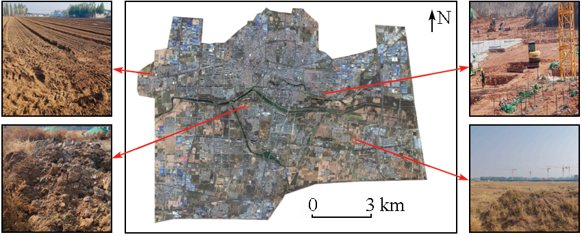
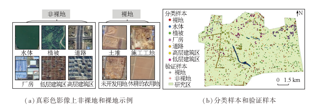
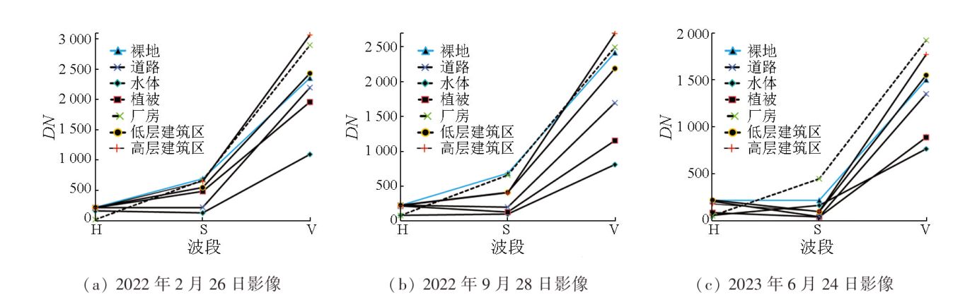
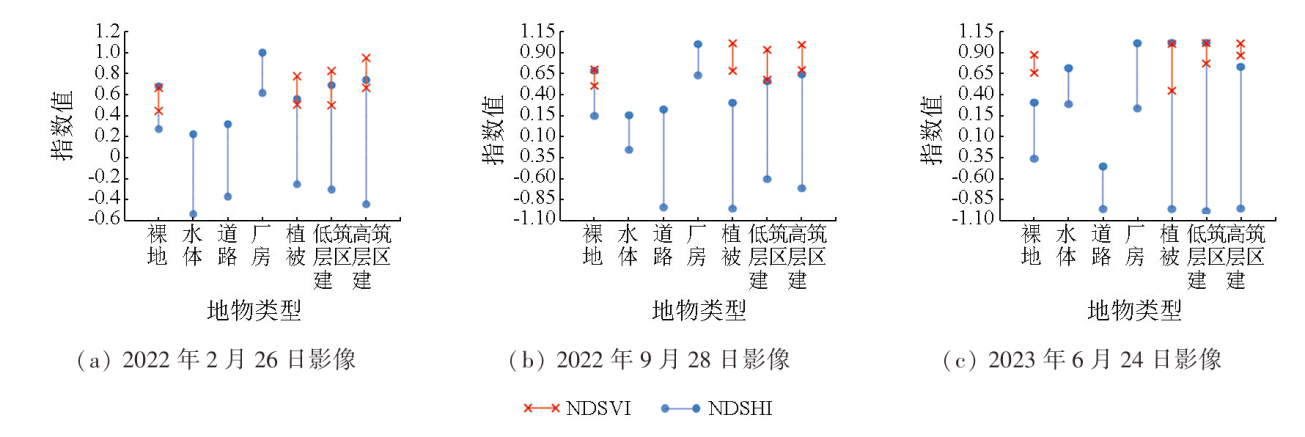
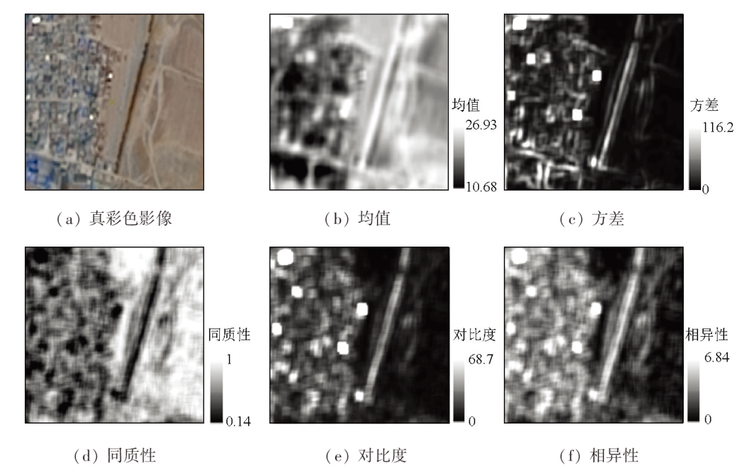
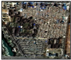
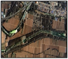
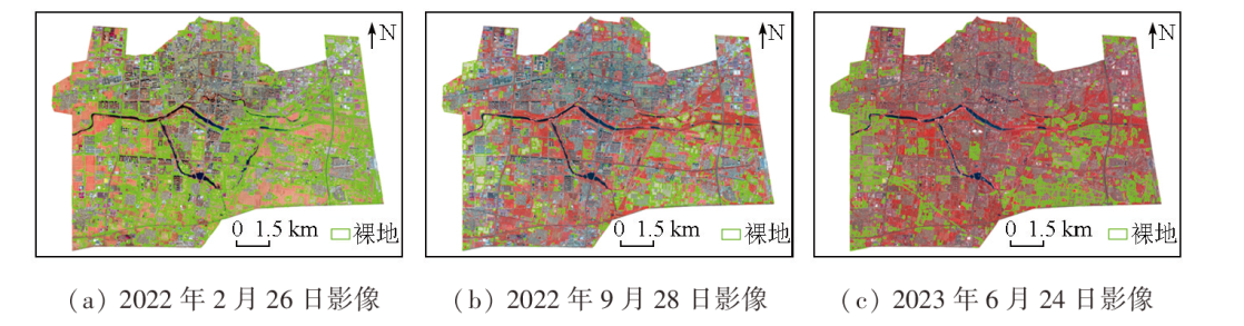
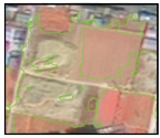
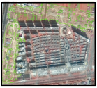
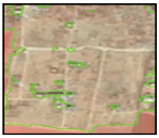
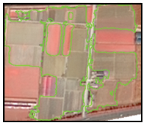
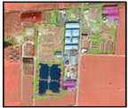
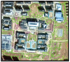
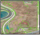
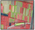
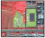
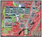
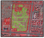
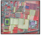
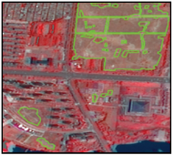
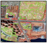
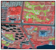
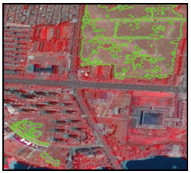
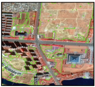
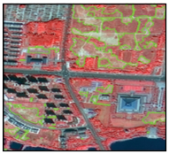
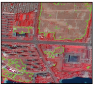
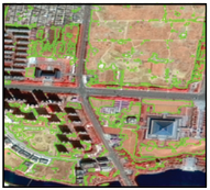
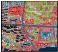
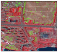
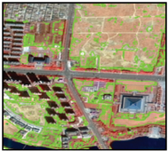
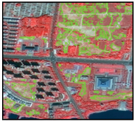
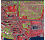
Abstract Extracting information about bare land is crucial for territorial planning, environmental protection, and sustainable development. However, current information extraction methods for bare land struggle to balance the extraction efficiency and accuracy in large-scale and multitemporal applications. This study constructed normalized difference indices based on the analysis of the hue-saturation-value (HSV) features. By combining texture features and vegetation index, this study proposed a simple, efficient hierarchical fine-scale information extraction method for bare land. This proposed method was applied to the urban area of Qufu City, Shandong Province, China. First, with three GF-1 satellite images as the data source, the red, green, and blue bands from the images were converted to the HSV color space. Based on the differences in H, S, and V components between bare land and other land types, the normalized difference SH and SV indices were constructed for preliminary hierarchical information extraction of bare land. Second, texture features were introduced to low-rise building areas and bare land, where the differences in H, S, and V components are nonsignificant. Different texture features were comparatively analyzed for further information extraction of bare land. Third, the normalized difference vegetation indices were used to achieve the final information extraction of bare land, followed by post-processing of the results. The results of this study demonstrate that the constructed normalized difference indices, combined with homogeneous texture features, showed the optimal extraction performance, with an overall accuracy of above 93% and a Kappa coefficient of above 0.84, outperforming other classification methods. Therefore, the proposed method proves effective in extracting information about bare land, serving as a novel approach for bare land information extraction.
|
| Keywords
GF-1
hierarchical fine-scale information extraction of bare land
HSV
texture feature
|
|
|
|
Issue Date: 09 May 2025
|
|
|
| [1] |
刘奥博, 吴其重, 陈雅婷, 等. 北京市平原区裸露地风蚀扬尘排放量[J]. 中国环境科学, 2018, 38(2):471-477.
|
| [1] |
Liu A B, Wu Q Z, Chen Y T, et al. Estimation of dust emissions from bare soil erosion over Beijing Plain Area[J]. China Environmental Science, 2018, 38(2):471-477.
|
| [2] |
中国工程建设标准化协会. T/CECS 995—2022建筑施工裸地遥感监测技术导则[S]. 北京: 中国建筑出版社, 2022.
|
| [2] |
China Association for Standardization of Engineering Construction. T/CECS 995—2022 Technical guidelines for remote sensing monitoring of bare land in construction[S]. Beijing: China Architecture Press, 2022.
|
| [3] |
熊文成, 徐永明, 李京荣, 等. 天津市扬尘污染源中高分辨率遥感监测[J]. 遥感信息, 2017, 32(3):45-49.
|
| [3] |
Xiong W C, Xu Y M, Li J R, et al. Urban dust pollution sources monitoring based on medium and high resolution satellite imagery in Tianjin[J]. Remote Sensing Information, 2017, 32(3):45-49.
|
| [4] |
孙一鸣, 张宝钢, 吴其重, 等. 国产微景一号小卫星影像的城市裸地识别应用[J]. 自然资源遥感, 2022, 34(1):189-197.doi:10.6046/zrzyyg.2021056.
|
| [4] |
Sun Y M, Zhang B G, Wu Q Z, et al. Application of domestic low-cost micro-satellite images in urban bare land identification[J]. Remote Sensing for Natural Resources, 2022, 34(1):189-197.doi:10.6046/zrzyyg.2021056.
|
| [5] |
邱永红, 谭永忠, 周国华. 一种遥感影像裸土地特征增强方法[J]. 计算机工程与应用, 2012, 48(32):196-199.
|
| [5] |
Qiu Y H, Tan Y Z, Zhou G H. Feature enhancement method for bare land in remote sensing images[J]. Computer Engineering and Applications, 2012, 48(32):196-199.
|
| [6] |
Nguyen C T, Chidthaisong A, Kieu D P, et al. A modified bare soil index to identify bare land features during agricultural fallow-period in Southeast Asia using Landsat8[J]. Land, 2021, 10(3):231.
|
| [7] |
方洪科, 刘贵芬, 朱从旭, 等. 山东省滨州市裸露地面遥感监测及简要分析[C]// 中国环境科学学会2023年科学技术年会论文集(四). 南昌, 2023:267-269.
|
| [7] |
Fang H K, Liu G F, Zhu C X, et al. Remote sensing monitoring and brief analysis of bare land in Binzhou City,Shandong Province[C]// Chinese Society for Environmental Sciences.Proceedings of the 2023 Science and Technology Annual Conference of the Chinese Society for Environmental Sciences(4). Nanchang, 2023:267-269.
|
| [8] |
Rogers A S, Kearney M S. Reducing signature variability in unmixing coastal marsh Thematic Mapper scenes using spectral indices[J]. International Journal of Remote Sensing, 2004, 25(12):2317-2335.
|
| [9] |
Chen W, Liu L, Zhang C, et al. Monitoring the seasonal bare soil areas in Beijing using multitemporal TM images[C]// IGARSS 2004.2004 IEEE International Geoscience and Remote Sensing Symposium.Anchorage,AK.IEEE, 2004:3379-3382.
|
| [10] |
吴志杰, 赵书河. 基于TM图像的“增强的指数型建筑用地指数”研究[J]. 国土资源遥感, 2012, 24(2):50-55.doi:10.6046/gtzyyg.2012.02.10.
|
| [10] |
Wu Z J, Zhao S H. A study of enhanced index-based built-up index based on Landsat TM imagery[J]. Remote Sensing for Land and Resources, 2012, 24(2):50-55.doi:10.6046/gtzyyg.2012.02.10.
|
| [11] |
As-syakur A R, Adnyana I W S, Arthana I W, et al. Enhanced built-up and bareness index (EBBI) for mapping built-up and bare land in an urban area[J]. Remote Sensing, 2012, 4(10):2957-2970.
|
| [12] |
张雅琼, 赵宇昕, 屈冉, 等. 基于GF-1卫星遥感影像的生态空间周边建筑余泥渣土场提取方法研究[J]. 环境保护科学, 2018, 44(6):50-55,89.
|
| [12] |
Zhang Y Q, Zhao Y X, Qu R, et al. Study of extraction method of construction waste residue fields around ecological space based on GF-1 satellite remote sensing image[J]. Environmental Protection Science, 2018, 44(6):50-55,89.
|
| [13] |
李霞, 徐涵秋, 李晶, 等. 基于NDSI和NDISI指数的SPOT-5影像裸土信息提取[J]. 地球信息科学学报, 2016, 18(1):117-123.
doi: 10.3724/SP.J.1047.2016.00117
|
| [13] |
Li X, Xu H Q, Li J, et al. Extraction of bare soil features from SPOT-5 imagery based on NDSI and NDISI[J]. Journal of Geo-Information Science, 2016, 18(1):117-123.
|
| [14] |
尚明, 马杰, 李悦, 等. Landsat和GF数据面向对象土地覆盖分类研究[J]. 自然资源遥感, 2024. 36(3):240-247.doi:10.6046/zrzyyg.2023135.
|
| [14] |
Shang M, Ma J, Li Y, et al. Research on object-oriented land cover classification of Landsat and GF data[J]. Remote Sensing for Natural Resources, 2024. 36(3):240-247.doi:10.6046/zrzyyg.2023135.
|
| [15] |
孟晋杰, 王建华. 高分一号影像数据城市生态用地监测[J]. 测绘科学, 2016, 41(9):33-37.
|
| [15] |
Meng J J, Wang J H. Monitoring of urban ecological land use based on Gaofen-1 data[J]. Science of Surveying and Mapping, 2016, 41(9):33-37.
|
| [16] |
朱皓辰, 吴艳兰, 何彬方. 基于改进DenseNet模型的高分遥感影像城市裸地提取[J]. 安徽农业大学学报, 2022, 49(5):799-808.
|
| [16] |
Zhu H C, Wu Y L, He B F. Extraction of urban bare land from high-resolution remote sensing images based on improved DenseNet model[J]. Journal of Anhui Agricultural University, 2022, 49(5):799-808.
|
| [17] |
邱昀, 姜磊, 李金香, 等. 深度学习在裸地扬尘源监测中的应用研究[J]. 中国环境监测, 2023, 39(s1):72-79.
|
| [17] |
Qiu Y, Jiang L, Li J X, et al. Research on the application of deep learning in monitoring dust sources in bare land[J]. Environmental Monitoring in China, 2023, 39(s1):72-79.
|
| [18] |
宋承运, 曲雪杉, 胡光成, 等. 基于NDVI-NSSI空间与HSV变换的成熟期农作物遥感识别[J]. 农业机械学报, 2023, 54(8):193-200.
|
| [18] |
Song C Y, Qu X S, Hu G C, et al. Crop identification in mature stage with remote sensing based on NDVI-NSSI space and HSV transformation[J]. Transactions of the Chinese Society for Agricultural Machinery, 2023, 54(8):193-200.
|
| [19] |
陶欢, 李存军, 谢春春, 等. 基于HSV阈值法的无人机影像变色松树识别[J]. 南京林业大学学报(自然科学版), 2019, 43(3):99-106.
doi: 10.3969/j.issn.1000-2006.201711035
|
| [19] |
Tao H, Li C J, Xie C C, et al. Recognition of red-attack pine trees from UAV imagery based on the HSV threshold method[J]. Journal of Nanjing Forestry University (Natural Sciences Edition), 2019, 43(3):99-106.
|
| [20] |
林雨准, 张保明, 郭海涛, 等. HSV变换和多尺度分割相结合的高分辨率遥感影像阴影检测[J]. 测绘科学技术学报, 2017, 34(5):486-490.
|
| [20] |
Lin Y Z, Zhang B M, Guo H T, et al. Shadow detection from high resolution remote sensing imagery based on HSV transformation and multilevel segmentation[J]. Journal of Geomatics Science and Technology, 2017, 34(5):486-490.
|
| [21] |
Haralick R M, Shanmugam K, Dinstein I. Textural features for image classification[J]. IEEE Transactions on Systems,Man,and Cybernetics, 1973, SMC-3(6):610-621.
|
| [22] |
Rouse J, Haas R H, Schell J A, et al. Monitoring vegetation systems in the Great Plains with ERTS[J]. NASA Special Publication, 1974, 351:309.
|
| [23] |
Song C, Woodcock C E, Seto K C, et al. Classification and change detection using landsat TM data when and how to correct atmospheric effects?[J]. Remote Sensing of Environment, 2001, 75(2):230-244.
|
|
Viewed |
|
|
|
Full text
|
|
|
|
|
Abstract
|
|
|
|
|
Cited |
|
|
|
|
| |
Shared |
|
|
|
|
| |
Discussed |
|
|
|
|
 2025,
Vol. 37
2025,
Vol. 37