|
|
 |
|

|
|
|
Remote sensing-based detection of dams in the Daqing River basin through optimization using hard negative samples of bridges |
GUO Yong1( ), ZHANG Linxiang1, XU Zeyu2, CAI Zhongxiang1 ), ZHANG Linxiang1, XU Zeyu2, CAI Zhongxiang1 |
1. Geospatial Information Institute, Information Engineering University, Zhengzhou 450052,China
2. National Engineering Research Center for Geomatics, Aerospace Information Research Institute, Chinese Academy of Sciences, Beijing 100101, China |
|
|
|
|
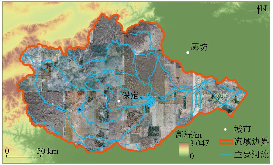
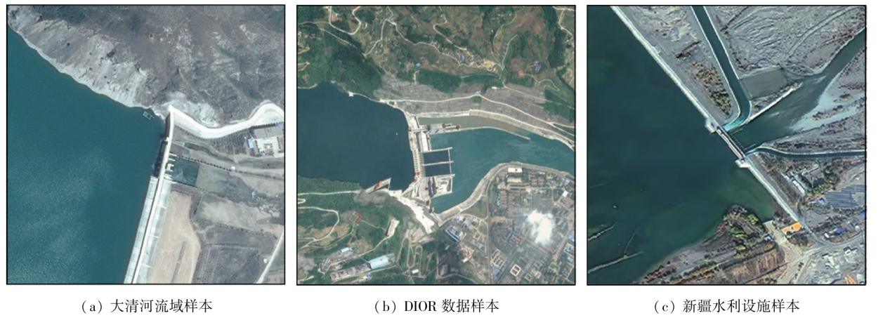
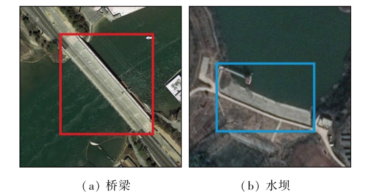
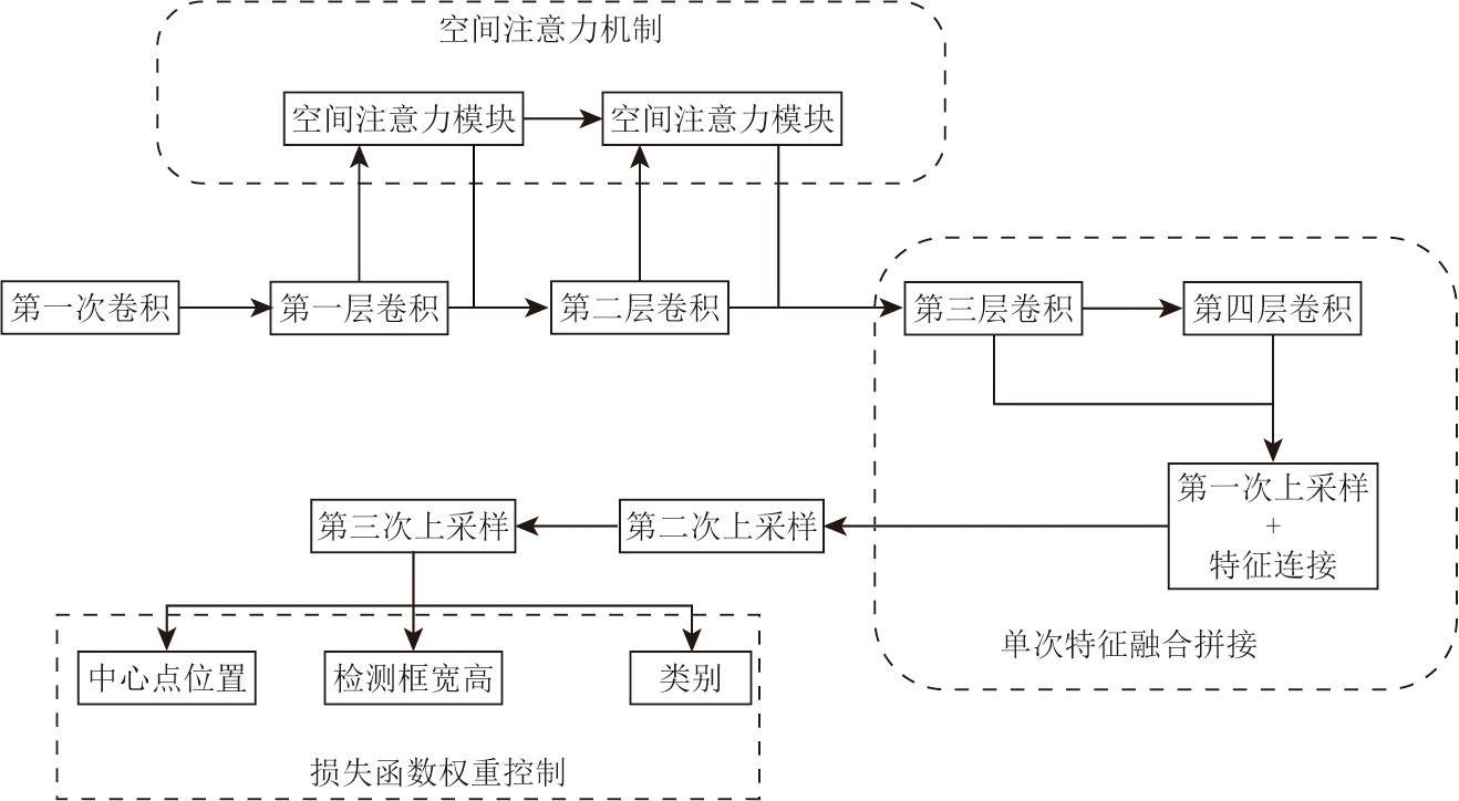
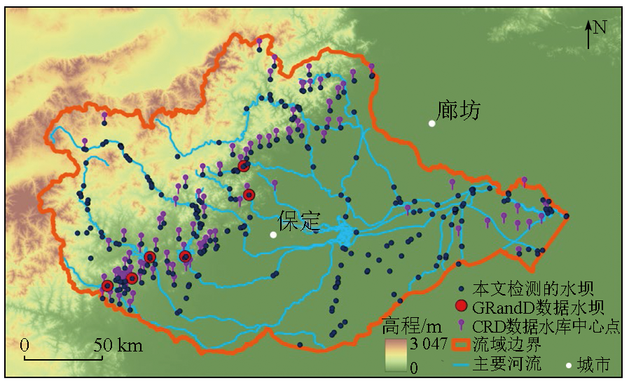
Abstract The dam detection is crucial for urban planning, ecological environment assessment, and other purposes. Currently, research on remote-sensing-based dam detection mainly focuses on algorithm improvements using sample sets or small-scale localized detections, with a significant gap in practical applications over large-scale geographical regions. In large-scale regions, the sparse distribution of dams, along with the presence of more surface features such as bridges, significantly interferes with dam detection. To address this issue, this study explored the Daqing River basin as a case study to investigate remote sensing methods for dam detection in large-scale regions. This study consisted of two main phases. In the first stage, bridges, which are easily confused with dams, are considered hard negative samples (i.e., samples prone to false positives) for training. The neural network structure suitable for dam detection was improved based on the DIOR open dataset. In the second phase, the detection model was developed through fine-scale tuning using the optimized network alongside multi-source sample data from the large Daqing River basin. Concurrently, dams within the Daqing River region were detected. The optimized model yielded dam detection F1 of 0.783 in the first phase of tests and identified 330 dams in the Daqing River basin during the second phase. These results align with the existing publicly available dam spatial distribution dataset GRandD, even providing more details. The results of this study indicate that the model, optimized using bridge samples, can effectively mitigate the incorrect extraction of bridges, thereby improving detection accuracy.
|
| Keywords
dam
hard negative samples
Daqing River basin
CenterNet
object detection
|
|
|
|
Issue Date: 23 December 2024
|
|
|
| [1] |
许莹, 张友静, 张琴. 基于高分影像的水利空间要素提取规则集构建[J]. 地理空间信息, 2016, 14(5):71-74,7.
|
| [1] |
Xu Y, Zhang Y J, Zhang Q. Rule sets building of water conservancy facilities spatial element extraction based on high resolution remote sensing image[J]. Geospatial Information, 2016, 14(5):71-74,7.
|
| [2] |
朱然. 大数据量复杂背景下桥梁水坝目标快速识别[D]. 成都: 电子科技大学, 2015.
|
| [2] |
Zhu R. Fast recognition of bridge and dam in complex background through masses of data[D]. Chengdu: University of Electronic Science and Technology of China, 2015.
|
| [3] |
孙宇, 黄亮, 赵俊三, 等. 结合随机擦除和YOLOv4的高空间分辨率遥感影像桥梁自动检测[J]. 自然资源遥感, 2022, 34(2):97-104.doi:10.6046/zrzyyg.2021130.
|
| [3] |
Sun Y, Huang L, Zhao J S, et al. High spatial resolution automatic detection of bridges with high spatial resolu tion remote sensing images based on random erasure and YOLOv4[J]. Remote Sensing for Natural Resources, 2022, 34(2):97-104.doi:10.6046/zrzyyg.2021130.
|
| [4] |
邱丹丹, 马洪超, 杨耘, 等. 基于多源卫星图像融合的水坝检测方法的研究[J]. 遥感学报, 2006, 10(4):449-455.
|
| [4] |
Qiu D D, Ma H C, Yang Y, et al. A study of dam detection based on multi-source satellite images fusion[J]. National Remote Sensing Bulletin, 2006, 10(4):449-455.
|
| [5] |
Redmon J, Divvala S, Girshick R, et al. You only look once:Unified,real-time object detection[C]// 2016 IEEE Conference on Computer Vision and Pattern Recognition (CVPR).Las Vegas,NV,USA.IEEE, 2016:779-788.
|
| [6] |
Redmon J, Farhadi A. YOLOv3:An incremental improvement[J/OL]. arXiv, 2018. http://arxiv.org/abs/1804.02767.pdf.
url: http://arxiv.org/abs/1804.02767.pdf
|
| [7] |
Liu W, Anguelov D, Erhan D, et al. SSD:Single shot MultiBox detector[C]// European Conference on Computer Vision.Cham:Springer, 2016:21-37.
|
| [8] |
Ren S, He K, Girshick R, et al. Faster R-CNN:Towards real-time object detection with region proposal networks[J]. IEEE Transactions on Pattern Analysis and Machine Intelligence, 2017, 39(6):1137-1149.
|
| [9] |
郭进祥, 刘立波, 徐峰, 等. 基于YOLO v3的机场场面飞机检测方法[J]. 激光与光电子学进展, 2019, 56(19):191003.
|
| [9] |
Guo J X, Liu L B, Xu F, et al. Airport scene aircraft detection method based on YOLO v3[J]. Laser & Optoelectronics Progress, 2019, 56(19):191003.
|
| [10] |
戴伟聪, 金龙旭, 李国宁, 等. 遥感图像中飞机的改进YOLOv3实时检测算法[J]. 光电工程, 2018, 45(12):180350.
|
| [10] |
Dai W C, Jin L X, Li G N, et al. Real-time airplane detection algorithm in remote-sensing images based on improved YOLOv3[J]. Opto-Electronic Engineering, 2018, 45(12):180350.
|
| [11] |
王文胜. 宽幅光学遥感图像舰船飞机目标检测识别技术研究[D]. 长春: 中国科学院大学(中国科学院长春光学精密机械与物理研究所), 2018.
|
| [11] |
Wang W S. Research on technology of ship and aircraft targets recognition from large-field optical remote sensing image[D]. Changchun: Changchun Institute of Optics,Fine Mechanics and Physics,Chinese Academy of Sciences, 2018.
|
| [12] |
王彦情, 马雷, 田原. 光学遥感图像舰船目标检测与识别综述[J]. 自动化学报, 2011, 37(9):1029-1039.
|
| [12] |
Wang Y Q, Ma L, Tian Y. State-of-the-art of ship detection and recognition in optical remotely sensed imagery[J]. Acta Automatica Sinica, 2011, 37(9):1029-1039.
|
| [13] |
种劲松. 合成孔径雷达图像舰船目标检测算法与应用研究[D]. 北京: 中国科学院研究生院(电子学研究所), 2002.
|
| [13] |
Zhong J S. A study on the algorithm of ship target detection in SAR imagery and its applications[D]. Beijing: Graduate School of Chinese Academy of Sciences(Institute of Electrics), 2002.
|
| [14] |
孙秉义, 文珊珊, 吴昊, 等. 基于深度学习的高分辨率遥感图像车辆检测[J]. 东华大学学报(自然科学版), 2018, 44(4):520-525.
|
| [14] |
Sun B Y, Wen S S, Wu H, et al. Vehicle detection in high-resolution remote sensing images based on deep learning[J]. Journal of Donghua University (Natural Science), 2018, 44(4):520-525.
|
| [15] |
冯素婷, 盛智勇, 后兴海, 等. 基于旋转框回归的YOLOV5遥感图像车辆目标检测[C]// 第十五届全国信号和智能信息处理与应用学术会议论文集. 北京: 计算机工程与应用, 2022:4.
|
| [15] |
Feng S T, Sheng Z Y, Hou X H, et al. Vehicle target detection in YOLOV5 remote sensing image based on rotating box regression[C]// Anthology of the 15th National Academic Conference on Signal and Intelligent Information Processing and Application, Beijing: Computer Engineering and Applications, 2022:4.
|
| [16] |
刘康. 高分遥感影像建筑目标检测技术研究[D]. 西安: 中国科学院大学(中国科学院西安光学精密机械研究所), 2021.
|
| [16] |
Liu K. Research on building detection technology of the highresolution remote sensing images[D]. Xi’an: Xi’an Institute of Optics and Precision Mechanics,Chinese Academy of Sciences, 2021.
|
| [17] |
王玉龙, 蒲军, 赵江华, 等. 基于生成对抗网络的地面新增建筑检测[J]. 计算机应用, 2019, 39(5):1518-1522.
doi: 10.11772/j.issn.1001-9081.2018102083
|
| [17] |
Wang Y L, Pu J, Zhao J H, et al. Detection of new ground buildings based on generative adversarial network[J]. Journal of Computer Applications, 2019, 39(5):1518-1522.
doi: 10.11772/j.issn.1001-9081.2018102083
|
| [18] |
Jing M, Cheng L, Ji C, et al. Detecting unknown dams from high-resolution remote sensing images:A deep learning and spatial analysis approach[J]. International Journal of Applied Earth Observation and Geoinformation, 2021, 104:102576.
|
| [19] |
许泽宇, 沈占锋, 李杨, 等. 结合E-YOLO和水体指数约束的大面幅影像水利设施检测[J]. 遥感学报, 2022, 26(10):2083-2093.
|
| [19] |
Xu Z Y, Shen Z F, Li Y, et al. Detection of water conservancy facilities in large-format image combining E-YOLO algorithm and NDWI constraint[J]. National Remote Sensing Bulletin, 2022, 26(10):2083-2093.
|
| [20] |
Girshick R, Donahue J, Darrell T, et al. Rich feature hierarchies for accurate object detection and semantic segmentation[C]// Proceedings of the 2014 IEEE Conference on Computer Vision and Pattern Recognition.ACM, 2014:580-587.
|
| [21] |
张烨, 许艇, 冯定忠, 等. 基于难分样本挖掘的快速区域卷积神经网络目标检测研究[J]. 电子与信息学报, 2019, 41(6):1496-1502.
|
| [21] |
Zhang Y, Xu T, Feng D Z, et al. Research on faster RCNN object detection based on hard example mining[J]. Journal of Electronics & Information Technology, 2019, 41(6):1496-1502.
|
| [22] |
许悦雷, 朱明明, 马时平, 等. 迁移学习结合难分样本挖掘的机场目标检测[J]. 西安电子科技大学学报, 2018, 45(5):190-196.
|
| [22] |
Xu Y L, Zhu M M, Ma S P, et al. Airport object detection combining transfer learning and hard example mining[J]. Journal of Xidian University, 2018, 45(5):190-196.
|
| [23] |
马广阔. 遥感图像桥梁目标检测方法研究[D]. 呼和浩特: 内蒙古工业大学, 2021.
|
| [23] |
Ma G K. Research on bridge target detection method in remote sensing image[D]. Hohhot: Inner Mongolia University of Tehchnology, 2021.
|
| [24] |
Zhou X, Wang D, Krähenbühl P. Objects as points[J/OL]. arXiv, 2019. http://arxiv.org/abs/1904.07850.pdf.
url: http://arxiv.org/abs/1904.07850.pdf
|
| [25] |
李硕, 沈占锋, 刘克俭, 等. 大清河流域土地利用变化的地形梯度效应分析[J]. 农业工程学报, 2021, 37(5):275-284.
|
| [25] |
Li S, Shen Z F, Liu K J, et al. Analysis of terrain gradient effects of land use change in Daqing River basin[J]. Transactions of the Chinese Society of Agricultural Engineering, 2021, 37(5):275-284.
|
| [26] |
Li K, Wan G, Cheng G, et al. Object detection in optical remote sensing images:A survey and a new benchmark[J]. ISPRS Journal of Photogrammetry and Remote Sensing, 2020, 159:296-307.
|
| [27] |
Lehner B, Liermann C R, Revenga C, et al. High-resolution mapping of the world’s reservoirs and dams for sustainable river-flow management[J]. Frontiers in Ecology and the Environment, 2011, 9(9):494-502.
|
| [28] |
Song C, Fan C, Zhu J, et al. A comprehensive geospatial database of nearly 100 000 reservoirs in China[J]. Earth System Science Data, 2022, 14(9):4017-4034.
|
| [29] |
LeCun Y, Boser B, Denker J S, et al. Backpropagation applied to handwritten zip code recognition[J]. Neural Computation, 1989, 1(4):541-551.
|
| [30] |
Simonyan K, Zisserman A. Very deep convolutional networks for large-scale image recognition[J/OL]. arXiv, 2014(2014-09-04)[2023-05-23]. https://arxiv.org/abs/1409.1556.
url: https://arxiv.org/abs/1409.1556
|
| [31] |
Ronneberger O, Fischer P, Brox T. U-net:Convolutional networks for biomedical image segmentation[C]// International Conference on Medical Image Computing and Computer-Assisted Intervention.Cham:Springer, 2015:234-241.
|
| [32] |
He K, Zhang X, Ren S, et al. Deep residual learning for image recognition[C]// 2016 IEEE Conference on Computer Vision and Pattern Recognition (CVPR).Las Vegas,NV,USA.IEEE, 2016:770-778.
|
| [33] |
Badrinarayanan V, Kendall A, Cipolla R. SegNet:A deep convolutional encoder-decoder architecture for image segmentation[J]. IEEE Transactions on Pattern Analysis and Machine Intelligence, 2017, 39(12):2481-2495.
doi: 10.1109/TPAMI.2016.2644615
pmid: 28060704
|
| [34] |
Wang C Y, Bochkovskiy A, Liao H Y M. YOLOv7:Trainable bag-of-freebies sets new state-of-the-art for real-time object detectors[C]// 2023 IEEE/CVF Conference on Computer Vision and Pattern Recognition (CVPR).Vancouver,BC,Canada.IEEE, 2023:7464-7475.
|
| [35] |
Girshick R. Fast R-CNN[C]// 2015 IEEE International Conference on Computer Vision (ICCV).Santiago,Chile.IEEE, 2015:1440-1448.
|
| [36] |
李大伟. 固定翼无人机地面车辆目标自动检测与跟踪[D]. 北京: 中国科学院大学(中国科学院国家空间科学中心), 2017.
|
| [36] |
Li D W. Automatic vehicle detection and tracking in aerial images by fixed-wing UAV[D]. Beijing: National Space Science Center,Chinese Academy of Sciences, 2017.
|
| [37] |
王金传, 谭喜成, 王召海, 等. 基于Faster R-CNN深度网络的遥感影像目标识别方法研究[J]. 地球信息科学学报, 2018, 20(10):1500-1508.
doi: 10.12082/dqxxkx.2018.180237.
|
| [37] |
Wang J C, Tan X C, Wang Z H, et al. Faster R-CNN deep learning network based object recognition of remote sensing image[J]. Journal of Geo-Information Science, 2018, 20(10):1500-1508.
|
|
Viewed |
|
|
|
Full text
|
|
|
|
|
Abstract
|
|
|
|
|
Cited |
|
|
|
|
| |
Shared |
|
|
|
|
| |
Discussed |
|
|
|
|
 2024,
Vol. 36
2024,
Vol. 36