|
|
|
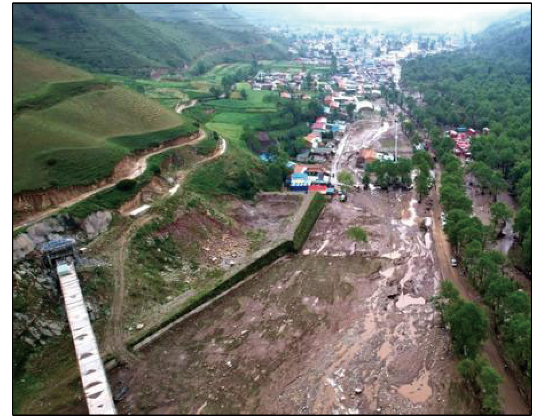
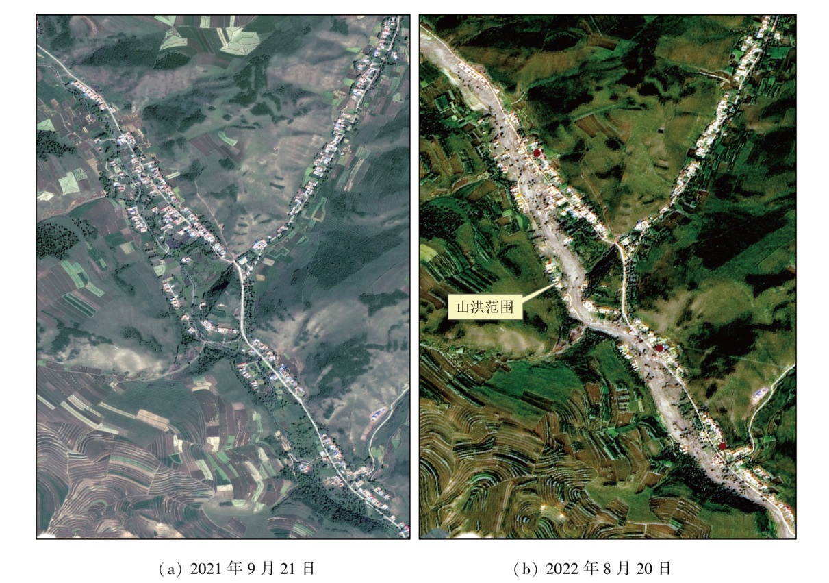
Abstract In the early morning of August 18, 2022, a flash flood occurred in Datong Hui and Tu Autonomous County, Xining City, Qinghai Province, resulting in 26 deaths and 5 missing. This flash flood is a typical event of multiple casualties caused by a creek disaster. The superimposed effect of rainfall directly led to this flash flood. The early continuous rainfall caused soil moisture content to reach or approach saturation. On the night of August 17, 2022, local short-time heavy rainfall smashing historical records, which could not infiltrate into the soil or be retained by vegetation, resulted in a flash flood. As revealed by the comprehensive analysis of remote sensing data, digital elevation model, field data, and media data, the flash flood area exhibited a large catchment area, a narrow river valley, a high relative height difference, a shallow river channel, and many obstacles. Consequently, the flash flood manifested high potential energy, a long movement distance, and locally severe backwater overflow, destroying some houses, farmland, and roads on both sides of the river channel. Against the backdrop of global changes, low-risk areas of flash floods, including the arid region of northwest China and the Qinghai-Tibet Plateau, display significantly increased precipitation and frequent local short-time heavy rainfall. Hence, creeks in these low-risk areas are exposed to increasing risks of flash floods and even catastrophic ones. Additionally, heavy rainfall might induce the recurrence of flash floods in disaster areas.
|
| Keywords
flash flood
origin and characteristics
remote sensing monitoring
risk analysis
|
|
|
|
Issue Date: 14 June 2024
|
|
|
| [1] |
崔鹏, 邹强. 山洪泥石流风险评估与风险管理理论与方法[J]. 地理科学进展, 2016, 35(2):137-147.
doi: 10.18306/dlkxjz.2016.02.001
|
| [1] |
Cui P, Zou Q. Theory and method of risk assessment and risk management of debris flows and flash floods[J]. Progress in Geography, 2016, 35(2):137-147.
doi: 10.18306/dlkxjz.2016.02.001
|
| [2] |
张志彤. 我国山洪灾害特点及其防治思路[J]. 中国水利, 2007(14):14-15.
|
| [2] |
Zhang Z T. Characters of mountain flood disasters in China and prevention methods[J]. China Water Resources, 2007(14):14-15.
|
| [3] |
郭良, 丁留谦, 孙东亚, 等. 中国山洪灾害防御关键技术[J]. 水利学报, 2018, 49(9):1123-1136.
|
| [3] |
Guo L, Ding L Q, Sun D Y, et al. Key techniques of flash flood disaster prevention in China[J]. Journal of Hydraulic Engineering, 2018, 49(9):1123-1136.
|
| [4] |
胡焕庸. 中国人口之分布—附统计表与密度图[J]. 地理学报, 1935(2):33-74.
doi: 10.11821/xb193502002
|
| [4] |
Hu H Y. Distribution of population in China - statistical table and density map[J]. Acta Geographica Sinica, 1935(2):33-74.
|
| [5] |
刘业森, 杨振山, 黄耀欢, 等. 建国以来中国山洪灾害时空演变格局及驱动因素分析[J]. 中国科学:地球科学, 2019, 49(2):408-420.
|
| [5] |
Liu Y S, Yang Z S, Huang Y H, et al. Spatiotemporal evolution and driving factors of China’s flash flood disasters since 1949[J]. Scientia Sinica(Terrae), 2019, 49(2):408-420.
|
| [6] |
王澄海, 张晟宁, 张飞民, 等. 论全球变暖背景下中国西北地区降水增加问题[J]. 地球科学进展, 2021, 36(9):980-989.
doi: 10.11867/j.issn.1001-8166.2021.087
|
| [6] |
Wang C H, Zhang S N, Zhang F M, et al. On the Increase of precipitation in the northwestern China under the global warming[J]. Advances in Earth Science, 2021, 36(9):980-989.
doi: 10.11867/j.issn.1001-8166.2021.087
|
| [7] |
国务院. 国务院关于印发舟曲灾后恢复重建总体规划的通知[EB/OL].(2010-11-10)[ 2023-05-18]. http://www.gov.cn/zhengce/content/2010-11/10/content_6563.htm.
url: http://www.gov.cn/zhengce/content/2010-11/10/content_6563.htm
|
| [8] |
辛荣芳, 李宗仁, 张焜, 等. 青海省湟水流域地质灾害动态变化遥感监测[J]. 自然资源遥感, 2022, 34(4):254-261.doi:10.6046/zrzyyg.2021313.
|
| [8] |
Xin R F, Li Z R, Zhang K, et al. Remote sensing monitoring of the dynamic changes in geologic hazards in the Huangshui River basin of Qinghai Province[J]. Remote Sensing for Natural Resources, 2022, 34(4):254-261.doi:10.6046/zrzyyg.2021313.
|
| [9] |
大通土族回族自治县人民政府. 魅力大通.[EB/OL].[2023-05-18]. http://www.datong.gov.cn/.
url: http://www.datong.gov.cn/
|
| [9] |
People’s Government of Datong Tu and Hui Autonomous County. Charming Datong[EB/OL].[2023-05-18]. http://www.datong.gov.cn/.
url: http://www.datong.gov.cn/
|
| [10] |
张志军, 庄永成. 基于GF-1数据的地质灾害遥感调查—以青海大通县为例[J]. 科学技术与工程, 2017, 17(18):9-17.
|
| [10] |
Zhang Z J, Zhuang Y C. The survey of geological hazards based on GF-1 data: Taking example for Datong County,Qinghai Province[J]. Science Technology and Engineering, 2017, 17(18):9-17.
|
| [11] |
潘腾. 高分二号卫星的技术特点[J]. 中国航天, 2015(1):3-9.
|
| [11] |
PAN T. Technical characteristic of Gaofen-2 satellite[J]. Aerospace China, 2015(1):3-9.
|
| [12] |
张宏宇, 韩波, 王啸虎, 等. 资源一号02D卫星总体设计与技术特点[J]. 航天器工程, 2020, 29(6):10-18.
|
| [12] |
Zhang H Y, Han B, Wang X H, et al. System design and technique characteristic of ZY-1-02D satellite[J]. Spacecraft Engineering, 2020, 29(6):10-18.
|
| [13] |
魏红艳, 肖晨超, 宋庆君, 等. 资源一号02D卫星在轨测试自然资源典型应用[J]. 航天器工程, 2020, 29(6):148-154.
|
| [13] |
Wei H Y, Xiao C C, Song Q J, et al. Natural resources typical applications in on-orbit test of ZY-1-02D satellite[J]. Spacecraft Engineering, 2020, 29(6):148-154.
|
| [14] |
申茜, 姚月, 李利伟, 等. 北京市平原区2015年—2019年0.8 m地表反射率数据集[J]. 遥感学报, 2021, 25(11):2303-2312.
|
| [14] |
Shen Q, Yao Y, Li L, et al. Annual 0.8 m surface reflectance data set of Beijing plain area from 2015 to 2019[J]. National Remote Sensing Bulletin, 2021, 25(11):2303-2312.
|
| [15] |
薛玉斌, 王浡, 马洪婷. 青海大通县公布“8·18”山洪灾害成因.[EB/OL].(2022-08-19)[2023-05-18]. http://www.xinhuanet.com/2022-08/19/c_1128928016.htm.
url: http://www.xinhuanet.com/2022-08/19/c_1128928016.htm
|
| [15] |
Xue Y B, Wang B, Ma H T. Datong County, Qinghai Province announces the causes of the "8.18" flash flood disaster.[EB/OL].(2022-08-19)[2023-05-18]. http://www.xinhuanet.com/2022-08/19/c_1128928016.htm.
url: http://www.xinhuanet.com/2022-08/19/c_1128928016.htm
|
| [16] |
贾君. 青海东部黄土分布区山洪灾害成因、特点及防治措施[J]. 青海科技, 2011, 18(5):55-57.
|
| [16] |
Jia J. Flash flood causes,characteristics and prevention measures of loess area in eastern Qinghai[J]. Qinghai Science and Technology, 2011, 18(5):55- 57.
|
| [17] |
范一大, 和海霞, 李博, 等. 基于HJ-1 CCD数据的洪涝灾害范围动态监测研究——以黑龙江省抚远县为例[J]. 遥感技术与应用, 2016, 31(1):102-108.
|
| [17] |
Fan Y D, He H X, L B, et al. Research on flood disaster extent dynamics monitoring using HJ-1CCD:A case study in Fuyuan of Heilongjiang Province,Northestern China[J]. Remote sensing technology and application, 2016, 31(1):102-108.
|
| [18] |
施雅风, 沈永平, 李栋梁, 等. 中国西北气候由暖干向暖湿转型的特征和趋势探讨[J]. 第四纪研究, 2003, 23(2):152-164.
|
| [18] |
Shi Y F, Shen Y P, Li D L, et al. Discussion on the present climate change from warm-dry to warm-wet in northwest China[J]. Quaternary Sciences, 2003, 23(2):152-164.
|
| [19] |
何秉顺, 马美红, 李青, 等. 我国山洪灾害防治现状与特点探析[J]. 中国农村水利水电, 2021(5):133-138,144.
|
| [19] |
He B S, Ma M H, LI Q, et al. Current situation and characteristics of flash flood prevention in China[J]. China Rural Water and Hydropower, 2021(5):133-138,144.
|
|
Viewed |
|
|
|
Full text
|
|
|
|
|
Abstract
|
|
|
|
|
Cited |
|
|
|
|
| |
Shared |
|
|
|
|
| |
Discussed |
|
|
|
|
 2024,
Vol. 36
2024,
Vol. 36
 ), LI Bo2(