Research on ortho-rectification and true color synthesis technique of GF-1 WFV data in China-Pakistan Economic Corridor
Yizhe WANG1, Guo LIU2,3(), Li GUO1, Shihu ZHAO1, Xueli ZHANG4
1. Land Satellite Remote Sensing Application Center, Ministry of Natural Resources, Beijing 100048, China 2. National Engineering Research Center for Geographic Information System, Wuhan 430074, China 3. The National Geological Library of China, Beijing 100083, China 4. East China Mineral Exploration and Development Bureau, Nanjing 210007, China
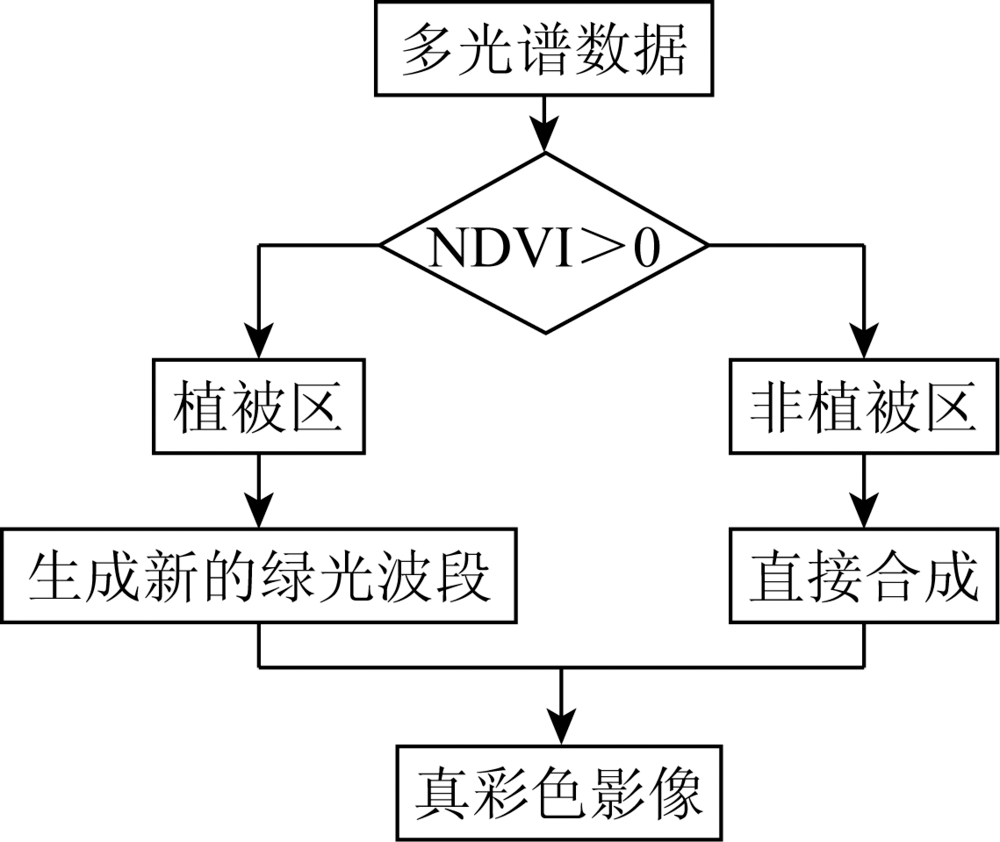
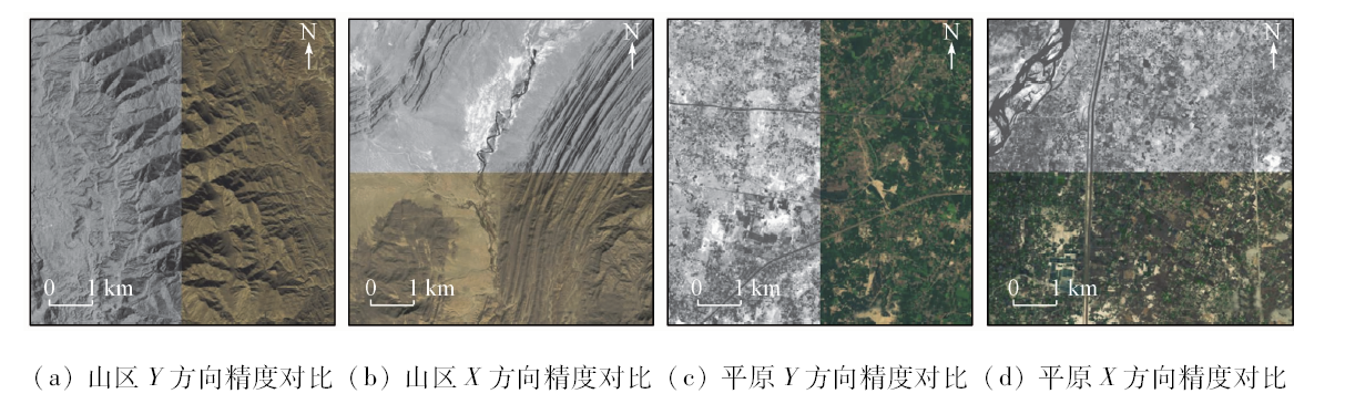
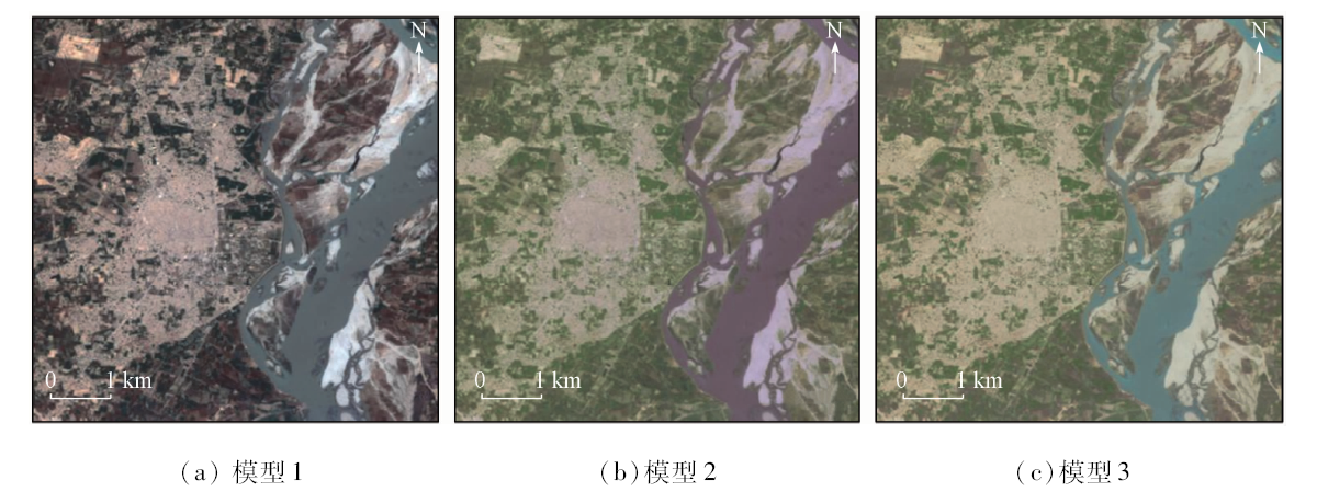
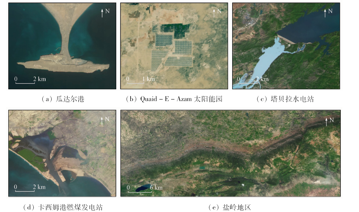
高分一号(GF-1)卫星自发射以来,凭借其幅宽大、综合覆盖能力强以及重访周期短等优势,已成为国土资源调查、农业林业遥感监测、国家重大工程建设等领域使用的重要数据源之一。以中巴经济走廊为研究区域,选取GF-1多光谱宽幅覆盖(wide field of view,WFV)数据进行对比试验,重点分析了影响遥感影像应用的2个关键因素: 如何提高遥感影像的几何定位精度和影像真彩色合成方式。研究结果表明,基于有理函数模型(rational polynomial coefficients,RPC)的区域网平差技术和RGB-NIR色彩合成模型对影像快速定位和提升视觉效果分别有良好的表现。成果正射影像X和Y方向均方根误差分别为0.79和0.83个像素; 成果影像的信息熵、平均梯度、均值和标准差等数值均有不同程度的提高,不仅确保了影像色彩真实自然,而且兼顾了信息细节,影像图面效果得到较好优化。该方法有助于进一步提升GF-1 WFV数据在实际生产中的业务化应用。
With its advantages of wide breadth, strong comprehensive coverage and short revisit period, GF-1 satellite has become one of the important data sources used in land and resources survey, remote sensing monitoring of agriculture and forestry, and major national engineering construction. In this study, the authors took the China-Pakistan Economic Corridor as an example, selected the GF-1 WFV data for comparative experiments, and analyzed two key factors that affect the application of remote sensing images, i.e., how to improve the geometric positioning accuracy of remote sensing images and the true color image synthesis method. The experimental results indicate that the block adjustment model based on rational function model technology and RGB-NIR color synthesis model have good performance in image accuracy and visual effect of imagery respectively. The X-direction residual and Y-direction residual of ortho-image were improved to 0.79 pixels and 0.83 pixels. The information entropy, average gradient, mean and standard deviation of the resulting images were improved in varying degrees. This method could not only ensure the true and natural color of the image but also keep the information details, with the image surface effect better optimized. This test method is a better strategy for large scale data application in actual production.
王懿哲, 刘国, 郭莉, 赵世湖, 张学利. 基于高分一号WFV数据的正射校正与真彩色合成技术——以中巴经济走廊为例[J]. 国土资源遥感, 2020, 32(2): 213-218.
Yizhe WANG, Guo LIU, Li GUO, Shihu ZHAO, Xueli ZHANG. Research on ortho-rectification and true color synthesis technique of GF-1 WFV data in China-Pakistan Economic Corridor. Remote Sensing for Land & Resources, 2020, 32(2): 213-218.
Shao Y S, Li J, Zhang S M, et al. Rectification methods based on line features for SPOT imagery[J]. Journal of Tongji University(Natural Science), 2010,38(8):1249-1254.
[2]
Fraser C S, Dial G, Grodecki J. Sensor orientation via RPCs[J]. ISPRS Journal of Photogrammetry and Remote Sensing, 2006,60(3):182-194.
[3]
Fontana F M A, Trishchenko A P, Khlopenkov K V, et al. Impact of orthorectification and spatial sampling on maximum NDVI composite data in mountain regions[J]. Remote Sensing of Environment, 2009,113(12):2701-2712.
Zhang G, Li D R, Yuan X X, et al. The mapping accuracy of satellite imagery block adjustment[J]. Journal of Geomatics Science and Technology, 2006,23(4):239-242.
[5]
张红英. 卫星遥感影像视觉效果增强模型及方法研究[D].武汉:中国地质大学(武汉), 2018.
Zhang H Y. The research on models and methods for the visual effect enhancement of satellite remote sensing imagery[D]. Wuhan:China University of Geosciences, 2018.
Tang X M, Zhang G, Zhu X Y, et al. Triple linear-array imaging geometry model of “ZY-3” surveying satellite and its validation[J]. Acta Geodaetica et Cartographica Sinica, 2012,41(2):191-198.
Li D R, Zhang G, Jiang W S, et al. SPOT-5 HRS satellite imagery block adjustment without GCPS or with single GCP[J]. Geomatics and Information Science of Wuhan University, 2006,31(5):377-381.
[8]
李德仁, 郑肇葆. 解析摄影测量学[M]. 北京: 测绘出版社, 1992: 174-184.
Li D R, Zheng Z B. Analytical photogrammetry[M]. Beijing: Surveying and Mapping Press, 1992: 174-184.
[9]
丁慧梅. 利用近红外提高多光谱遥感图像颜色自然性研究[D]. 昆明:云南师范大学, 2016.
Ding H M. Using near infrared to improve color naturalness of multi-spectral images[D]. Kunming:Yunnan Normal University, 2016.
Zhang W, Zheng X X. A method of true color synjournal of multi-spectral images based on vegetation index[J]. Geomatics and Spatial Information Technology, 2010,33(6):110-113.
Sun J B, Yang J Y, Zhang C, et al. Simulating true color technology applied to “ZY-1”02C satellite[J]. Remote Sensing for Land and Resources, 2013,25(4):33-39.doi: 10.6046/gtzyyg.2013.04.06.
Sun P, Dong Y S, Chen W T, et al. Research on fusion of GF-2 imagery and quality evaluation[J]. Remote Sensing for Land and Resources, 2016,28(4):108-113.doi: 10.6046/gtzyyg.2016.04.17.
 2020, Vol. 32
  ), 郭莉1, 赵世湖1, 张学利4