A study of the landscape fragmentations of land cover structure based on Landsat8 remote sensing image: A case study of Mata watershed in Yan’an, Shaanxi Province
LI Guoqing1,2(), HUANG Jinghua1,2, LIU Guan3, LI Jie3, ZHAI Bochao3, DU Sheng1,2
1. State Key Laboratory of Soil Erosion and Dryland Farming on the Loess Plateau, Northwest A&F University, Yangling 712100,China 2. Institute of Soil and Water Conservation, Chinese Academy of Sciences and Ministry of Water Resources,Yangling 712100, China 3. College of Forestry, Northwest A&F University, Yangling 712100, China
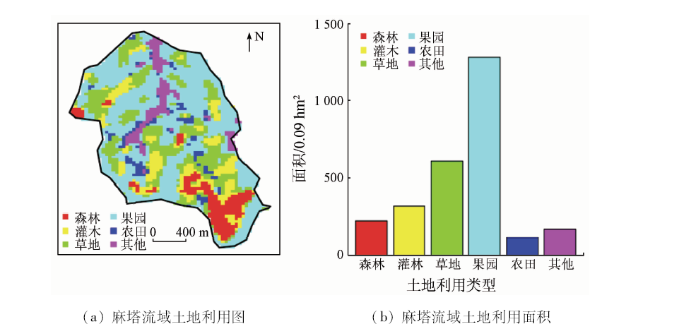
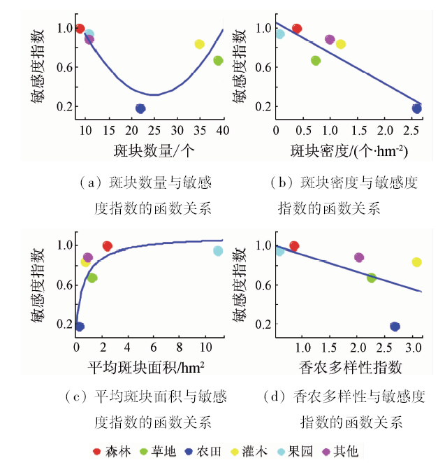
The process of landscape fragmentation is accompanied by the decline of landscape function. Therefore, the study of landscape fragmentation is of great significance for timely monitoring of ecological security and adjustment of land cover structure. This research was designed to map the current status of land cover structure of Mata watershed using supervised classification algorithms in south of Yan’an City based on Landsat 8 satellite data and to describe its landscape fragmentation using six fragmentation indices at three organization levels: patch, class, and landscape. The results are as follows: ① The status of land cover in this area can be characterized accurately based on Landsat8 satellite image and the accuracy of supervised classification is 74% together with the kappa value of 0.68; ② Mata watershed can be classified into 6 land cover classes, i.e., forest land, shrub land, grass land, orchards land, farm land, and others land (road and village). The orchard land occupies the largest area in all land cover types; ③ The extent of landscape fragmentation for shrub, grass and farm lands is relatively more serious than that of forest, orchard and others lands, indicating that landscape functions of shrub, grass and farm lands have been weakened in capability of ecological protection and agricultural production; ④ Transforming small patches of shrub, grass and farm lands into adjacent land type with large patches should improve the integration level of landscape in the Mata watershed, which is conducive to the improvement of landscape function in Mata watershed.
李国庆, 黄菁华, 刘冠, 李洁, 翟博超, 杜盛. 基于Landsat8卫星影像土地利用景观破碎化研究——以陕西省延安麻塔流域为例[J]. 国土资源遥感, 2020, 32(3): 121-128.
LI Guoqing, HUANG Jinghua, LIU Guan, LI Jie, ZHAI Bochao, DU Sheng. A study of the landscape fragmentations of land cover structure based on Landsat8 remote sensing image: A case study of Mata watershed in Yan’an, Shaanxi Province. Remote Sensing for Land & Resources, 2020, 32(3): 121-128.
Hong H J, Peng X C, Chen Z L, et al. The investigation of spatiotemporal patterns of landscape fragmentation during rapid urbanization in Changsha City[J]. Remote Sensing for Land and Resources, 2011,23(1):133-137.doi: 10.6046/gtzyyg.2011.01.27.
[3]
Nagendra H, Munroe D K, Southworth J. From pattern to process:Landscape fragmentation and the analysis of land use/land cover change[J]. Agriculture Ecosystems & Environment, 2004,101(2-3):111-115.
[4]
邬建国. 景观生态学——格局、过程、尺度与等级[M]. 北京: 高等教育出版社, 2000.
Wu J G. Landscape ecology:Pattern,process,scale and hierarchy[M]. Beijing: Higher Education Press, 2000.
Wang X L, Xiao D N, Bu R C, et al. Analysis on landscape patterns of Liaohe delta wetland[J]. Acta Ecologica Sinica, 1997,17(3):317-323.
[6]
Ferreira I J M, Bragion G D, Ferreira J H D, et al. Landscape pattern changes over 25 years across a hotspot zone in southern Brazil[J]. Southern Forests, 2019,81(2):175-184.
doi: 10.2989/20702620.2018.1542563
[7]
Wang B, Li J, Jin X F, et al. Mapping tea plantations from multi-seasonal landsat-8 OLI imageries using a random forest classifier[J]. Journal of the Indian Society of Remote Sensing, 2019,47(8):1315-1329.
doi: 10.1007/s12524-019-01014-5
Wei Y C, Wu B F, Zhang X W, et al. A quantitative analysis of the landscape pattern based on high resolution satellite image[J]. Remote Sensing for Land and Resources, 2009,21(2):76-81,86.doi: 10.6046/gtzyyg.2009.02.16.
Xu H Q, Tang F. Analysis of new characteristics of the first Landsat8 image and their ecoenvironmental significance[J]. Acta Ecologica Sinica, 2013,33(11):3249-3257.
doi: 10.5846/stxb
[10]
赵英时. 遥感应用分析原理与方法[M]. 北京: 科学出版社, 2003.
Zhao Y S. Principles and methods of remote sensing for applied anaysis[M]. Beijing: Science Press, 2003.
Wang M, Gao X H, Chen S Y, et al. The land use classification based on Landsat8 remote sensing image:A case study of Anqu demonstration community in Hongyuan County of Sichuan Province[J]. Pratacultural Science, 2015,32(5):694-701.
doi: 10.11829\j.issn.1001-0629.2014-0263
Li G Q, Zhang X Q, Du S. Simulating the boundary of forest and grass on the Loess Plateau based on random forest model[J]. China Sciencepaper, 2017,12(15):1780-1784.
[14]
杜盛, 刘国彬. 黄土高原植被恢复的生态功能[M]. 北京: 科学出版社, 2015.
Du S, Liu G B. Ecological functions of vegetation restoration on the loess plateau[M]. Beijing: Science Press, 2015.
Mai K L, Zhang W H. Object oriented classification approach for remote sensing imagery information extraction in loess hilly gully region[J]. Transactions of the Chinese Society of Agricultural Machinery, 2011,42(4):153-158.
Tan Y, Xu J L, Mao H Y. Research of optimum bands combination for vegetation information extraction based on Landsat8 image:A case study of Longquan City,Zhejiang Province[J]. East China Forest Management, 2019,33(2):71-76.
Zhang J L, Chang S. Optimum bands combination of Landsat8 image in land use classification:A case study of Enshi City,Hubei Province[J]. Journal of Hubei University for Nationalities(Natural Science Edition), 2015,33(4):467-470.
Hou X R, Xue Z J, Cheng M, et al. Soil organic carbon storage in Zhifanggou watershed of loess hilly region[J]. Bulletin of Soil and Water Conservation, 2012,32(2):21-25.
Wei N S. Dynamic sensing remote monitoring of forest cover based on high resolution images[J]. Information and Communications, 2019,3:19-22.
[21]
Thomas N, Hanna M, Florian D, et al. Satellite:Manipulating satellite data with satellite[EB/OL]. 2016, URL,https://cran.r-project.org/web/packages/satellite/index.html.
[22]
Li G Q, Du S, Wen Z M. Mapping the climatic suitable habitat of oriental arborvitae (Platycladus orientalis) for introduction and cultivation at a global scale[J]. Scientific Reports, 2016,6:30009.doi: 10.1038/srep30009.
doi: 10.1038/srep30009
pmid: 27443221
[23]
Stockwell D, Peters D. The GARP modelling system:Problems and solutions to automated spatial prediction[J]. International Journal of Geographical Information Science, 1999,13(2):143-158.
doi: 10.1080/136588199241391
[24]
Hijmans R J. Raster:Geographic data analysis and modeling.R package version 2.5-8 2016.https://CRAN.R-project.org/package=raster.
[25]
Mcgannon K R, Marks B J. FRAGSTATS:Spatial pattern analysis program for quantifying landscape structure[R].U.S.Department of Agriculture,Forest Service, Pacific Northwest Research Station, 1995.
Wang B, Liu H, Zhang S X, et al. Study on landscape fragmentation of Qinling huoditang forest region[J]. Chinese Agricultural Science Bulletin, 2005,21(10):111-113,143.
[27]
Vanderwal J, Falconi L, Januchowski S, et al.SDMTools:Species distribution modelling tools:tools for processing data associated with species distribution modelling exercises.R package version 1.1-221[EB/OL].2014. https://CRAN.R-project.org/package=SDMTools.
[28]
Araujo M B, New M. Ensemble forecasting of species distributions[J]. Trends in Ecology & Evolution, 2007,22(1):42-47.
doi: 10.1016/j.tree.2006.09.010
pmid: 17011070
[29]
Desmet P G. Using landscape fragmentation thresholds to determine ecological process targets in systematic conservation plans[J]. Biological Conservation, 2018,221:257-260.
doi: 10.1016/j.biocon.2018.03.025
[30]
Minor E S, Tessel S M, Engelhardt K A M, et al. The role of landscape connectivity in assembling exotic plant communities:A network analysis[J]. Ecology, 2009,90(7):1802-1809.
pmid: 19694129
[31]
Brassil C E. Mean time to extinction of a metapopulation with an Allee effect[J]. Ecological Modelling, 2001,143(1-2):9-16.
doi: 10.1016/S0304-3800(01)00351-9
 2020, Vol. 32
  ), 黄菁华1,2, 刘冠3, 李洁3, 翟博超3, 杜盛1,2