Automatic plotting of illegal mines based on ArcPy
LI Xiao1(), LIU Ying2, YAO Weiling1, YANG Jinzhong1, LI Yongzhi1, WANG Jie1
1. China Aero Geophysical Survey and Remote Sensing Center for Natural Resources,Beijing 100083, China 2. School of Resource and Environmental Sciences, Wuhan University, Wuhan 430079, China
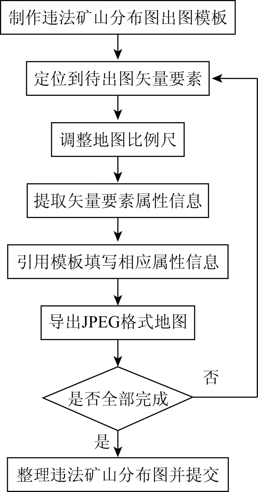
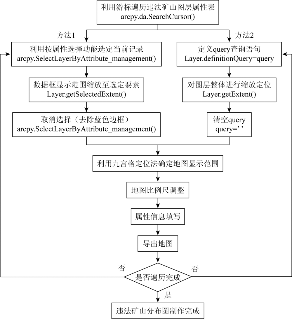
For the purpose of monitoring mine development status by using remote sensing technology, ArcGIS software is usually used to extract relevant information to produce illegal mine distribution maps, thus providing data support for relevant departments. At present, artificially produced illegal mine distribution maps have many problems, such as high production cost, high professionalism, large workload, inconsistent drawing format and low accuracy. Therefore, a method for automatically generating illegal mine distribution maps based on ArcPy is developed. The method automatically extracts the attribute information and spatial information of the remote sensing monitoring data of illegal mine mining areas, and automatically locates the image range and edits the text information according to the drawing template. The automatic generation of mine distribution maps greatly reduces the workload of technicians. It is of practical significance in improving the efficiency of mine remote sensing monitoring.
李霄, 刘莹, 姚维岭, 杨金中, 李勇志, 汪洁. 基于ArcPy的违法矿山自动出图方法[J]. 国土资源遥感, 2020, 32(3): 247-251.
LI Xiao, LIU Ying, YAO Weiling, YANG Jinzhong, LI Yongzhi, WANG Jie. Automatic plotting of illegal mines based on ArcPy. Remote Sensing for Land & Resources, 2020, 32(3): 247-251.
Yang J Z, Nie H F, Jing Q Q. Preliminary analysis of mine geo-environment status and existing problems in China[J]. Remote Sensing for Land and Resources, 2017,29(2):1-7.doi: 10.6046/gtzyyg.2017.02.01.
Diao M G, Liu F, Tan Z T, et al. Research and implement on automatic production method of mine remote sensing monitoring interpretation record table[J]. Remote Sensing for Land and Resources, 2018,30(4):212-217.doi: 10.6046/gtzyyg.2018.04.32.
Yang X H, Huang J, Tian L, et al. A discussion on comprehensive governance of mine environment based on high resolution remote sensing data:A case of Maoniuping REE deposit,Mianning County[J]. Remote Sensing for Land and Resources, 2015,27(4):115-121.doi: 10.6046/gtzyyg.2015.04.18.
[4]
Werner T T, Bebbington A, Gregory G. Assessing impacts of mining:Recent contributions from GIS and remote sensing[J]. The Extractive Industries and Society, 2019,6(3):993-1012.
Yang J Z, Zhao Y L. Technical features of remote sensing and its application in the geological survey and mineral resources survey[J]. Mineral Exploration, 2015,6(5):529-534.
Yao W L, Jing Q Q, Zhou Y J, et al. Analysis on typical pattern of mine geological environment restoration and governance based on remote sensing dynamic monitoring in Shandong[J]. Mineral Exploration, 2015,6(5):627-634.
[7]
He D, Le B T, Xiao D, et al. Coal mine area monitoring method by machine learning and multispectral remote sensing images[J]. Infrared Physics & Technology, 2019,103:103070.
[8]
Zhang B, Wu D, Zhang L, et al. Application of hyperspectral remote sensing for environment monitoring in mining areas[J]. Environmental Earth Sciences, 2012,65(3):649-658.
[9]
Demirel N, Emil M K, Duzgun H S. Surface coal mine area monitoring using multi-temporal high-resolution satellite imagery[J]. International Journal of Coal Geology, 2011,86(1):3-11.
Wang L J, Jin X, Jia H J, et al. Change detection for mine environment based on domestic high resolution satellite images[J]. Remote Sensing for Land and Resources, 2018,30(3):151-158.doi: 10.6046/gtzyyg.2018.03.21.
Yang J Z, Jing Q Q, Nie H F. Analysis of the mineral resources development status of remote sensing monitoring in national land[J]. Mineral Exploration, 2016,7(2):359-363.
Yang J Z, Qin X W, Nie H F, et al. Comprehensive research on remote sensing monitoring of the national concentration zones of the important mine[J]. Geological Survey of China, 2015,2(4):24-30.
Fang J. The study into rapid compiling of the initial database for the third national land survey based on ArcGIS platform[J]. Land & Resources Herald, 2019,16(2):29-34.
Sun X L, Xu H W, Li W B. Application of ArcPy in batch processing spatial data of Yangtze River[J]. Geomatics & Spatial Information Technology, 2015,38(2):97-99.
[15]
张康聪. 地理信息系统导论[M]. 北京: 科学出版社, 2019.
Zhang K C. Introduction to geographic information systems[M]. Beijing: Science Press, 2019.
 2020, Vol. 32
  ), 刘莹2, 姚维岭1, 杨金中1, 李勇志1, 汪洁1