The extraction of plateau lakes from SAR images based on Faster R-CNN and MorphACWE model
DONG Tiancheng1(), YANG Xiao1, LI Hui2, ZHANG Zhi1(), QI Rui3
1. Institute of Geophysics & Geomatics, China University of Geosciences, Wuhan 430074, China 2. School of Earth Science,China University of Geosciences, Wuhan 430074, China 3. 32023 Troops, Dalian 116032, China
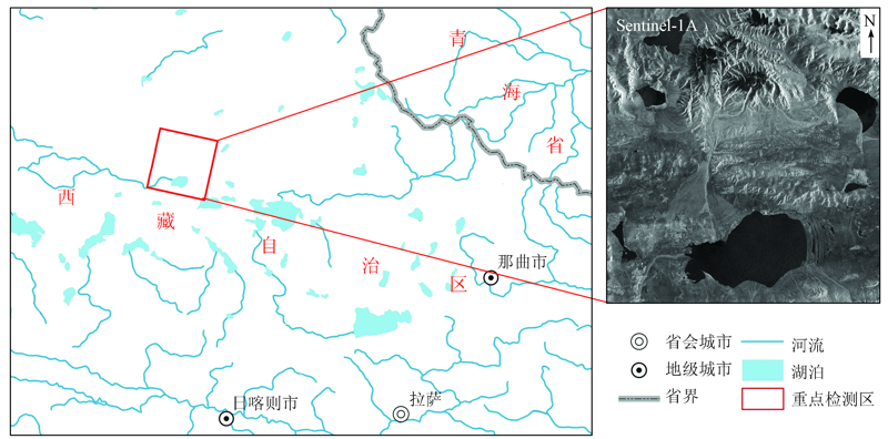
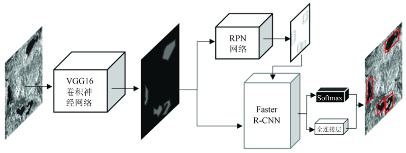
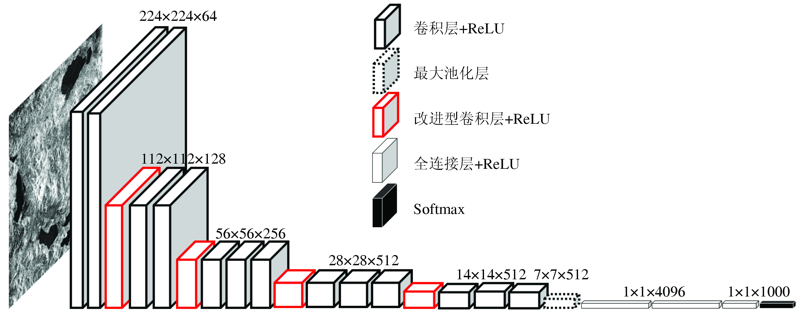
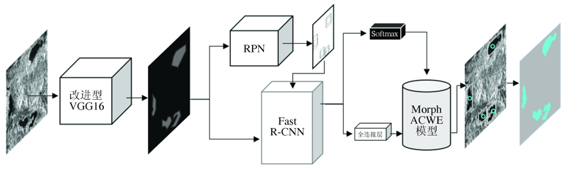
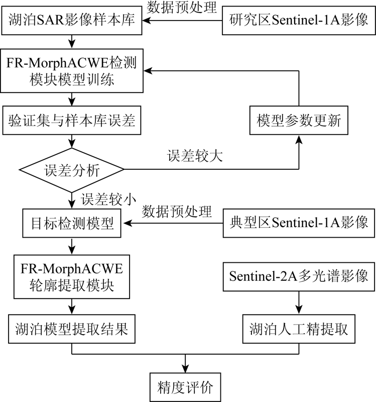
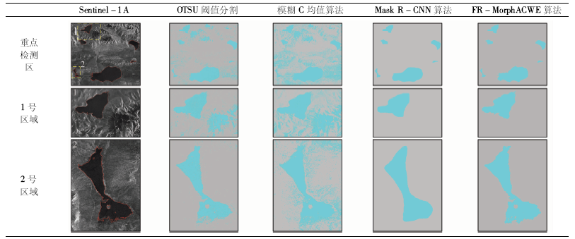
Lakes in the Tibetan Plateau constitute one of the most important natural factors in the plateau ecological environment. So, it is an urgent task to investigate and monitor lakes in the Tibetan Plateau. Because of the unique backscatter characteristics of water body in the image, the extraction and analysis of the lake based on SAR image has become a research hotspot. In order to further eliminate the interference of surface features and improve the classification accuracy, this paper proposes a high-precision lake extraction FR-MorphACWE (Faster Region-based Convolution Neural Network-MorphACWE) model of SAR image. The Interferometric Wide Swath (IW SLC) of the European Space Agency's sentinel-1A interference wide-band mode is used as the main data source, and the sentinel-2a multispectral image level-1c product is used as the reference data source. This model combines the morphological analysis advantages of Faster R-CNN target detection algorithm and the contour extraction advantages of MorphACWE model. The classification experiments were carried out from extraction of comprehensive interference multi-lake. The target detection algorithm was applied to eliminate non - lake surface disturbance. On such a basis, the active contour model was used to extract the lake boundary, and the morphological characteristics and radar reflection characteristics of plateau lakes were fully utilized to achieve high-precision extraction of plateau lakes from the south of Naqu City to the north of Xigaze City in Tibet. The experimental results show that the accuracy of the algorithm can reach 99.71% and the accuracy and recall rate are higher than 98% in the situation of multi-lake interference.
董天成, 杨肖, 李卉, 张志, 齐睿. 基于Faster R-CNN和MorphACWE模型的SAR图像高原湖泊提取[J]. 国土资源遥感, 2021, 33(1): 129-137.
DONG Tiancheng, YANG Xiao, LI Hui, ZHANG Zhi, QI Rui. The extraction of plateau lakes from SAR images based on Faster R-CNN and MorphACWE model. Remote Sensing for Land & Resources, 2021, 33(1): 129-137.
Lu S L, Xiao G H, Jia L, et al. Extraction of the spatial-temporal lake water surface dataset in the Tibetan Plateau over the past 10 years[J]. Remote Sensing for Land and Resources, 2016,28(3):181-187.doi: 10.6046/gtzyyg.2016.03.28.
An C J, Niu Z D, Li Z J, et al. Otsu threshold comparison and SAR water segmentation result analysis[J]. Journal of Electronics & Information Technology, 2010,32(9):2215-2219
Li Z H, Chen X W, Luo P, et al. A hybird thresholding method for water extraction in Envisat image[J]. Remote Sensing Information, 2013,28(2):62-65.
[7]
Hahmann T, Wessel B. Surface water body detection in high-resolution TerraSAR-X data using active contour models[C]// Synthetic Aperture Radar (EUSAR),2010 8th European Conference on.VDE, 2010.
Wang Q, Liao J J. Water area extraction and change detection of the Poyang Lake using SAR data[J]. Remote Sensing for Land and Resources, 2010(4):94-100.doi: 10.6046/gtzyyg.2010.04.19.
[9]
Jin H, Mountrakis G, Stehman S V. Assessing integration of intensity,polarimetric scattering,interferometric coherence and spatial texture metrics in PALSAR-derived land cover classification[J]. Isprs Journal of Photogrammetry & Remote Sensing, 2014,98:70-84.
Deng Y, Zhang H, Wang C, et al. An object-oriented water extraction method based on texture and polarimetric decomposition feature[J]. Remote Sensing Technology and Application, 2016,31(4):714-723.
Leng Y, Li N. Improved change detection method for flood monitoring[J]. Journal of Radars, 2017,6(2):204-212.
[12]
Sghaier M O, Foucher S, Lepage R. River extraction from high-resolution SAR images combining a structural feature set and mathematical morphology[J]. IEEE Journal of Selected Topics in Applied Earth Observations and Remote Sensing, 2016: 1-14.
[13]
Li N, Niu S, Guo Z, et al. Dynamic waterline mapping of inland great lakes using time-series SAR data from GF-3 and S-1A satellites:A case study of DJK reservoir,China[J]. IEEE Journal of Selected Topics in Applied Earth Observations and Remote Sensing, 2019,12(11):4297-4314.
[14]
Zhang Y, Chen J Q, Liu X, et al. Efficent extraction of Daihai Lake based on neural network algorithrn from high resolution SAR Image.2018 Progress in Electromagnetics Research Symposium (PIERS-Toyama),AUG 1-4,2018[C]. Toyama,JAPAN.
[15]
Shang F, Hirose A. Quaternion neural-network-based PolSAR land classification in poincare-sphere-parameter space[J]. IEEE Transactions on Geoscience and Remote Sensing, 2014,52(9):5693-5703.
[16]
Yang F Y, Feng T, Xu G Y, et al. Applied method for water-body segmentation based on mask R-CNN[J]. Journal of Applied Remote Sensing, 2020,14(1), 014502.
[17]
Kaiming H, Georgia G, Piotr D, et al. Mask R-CNN[J]. IEEE Transactions on Pattern Analysis and Machine Intelligence, 2018: 1.
[18]
Ren S Q, He K M, Girshick R, et al. Faster R-CNN:Towards real-time object detection with region proposal networks[J]. IEEE Transactions on Pattern Analysis & Machine Intelligence, 2015,39(6):1137-1149.
doi: 10.1109/TPAMI.2016.2577031
pmid: 27295650
[19]
Chen L C, Papandreou G, Kokkinos I, et al. DeepLab:Semantic image segmentation with deep convolutional nets,atrous convolution,and fully connected CRFs[J]. IEEE Transactions on Pattern Analysis and Machine Intelligence, 2018,40(4):834.
pmid: 28463186
[20]
Chan T F, Vese L A. Active contours without edges[J]. IEEE Transactions on Image Processing, 2001,10(2):266-277.
doi: 10.1109/83.902291
pmid: 18249617
[21]
Marquez-Neila P, Baumela L, Alvarez L. A Morphological approach to curvature-based evolution of curves and surfaces[J]. IEEE Transactions on Pattern Analysis and Machine Intelligence, 2014,36(1):2-17.
doi: 10.1109/TPAMI.2013.106
pmid: 24231862
Ma W, Chen D K, Yang N, et al. Time-series approach to estimate the soil moisture of a subsidence area by using dual polarimetric radar data[J]. Journal of Remote Sensing, 2018,22(3):521-534.
 2021, Vol. 33
  ), 杨肖1, 李卉2, 张志1(