Please wait a minute...
 
自然资源遥感  2022, Vol. 34 Issue (1): 135-141    DOI: 10.6046/zrzyyg.2021088
     技术方法 本期目录 | 过刊浏览 | 高级检索 |
一种基于GEE平台制作逐年土地覆盖数据的方法——以黄河流域为例
方梦阳1(), 刘晓煌2, 孔凡全1, 李明哲1, 裴小龙3
1.中国地质调查局海口海洋地质调查中心,海口 570000
2.中国地质调查局自然资源综合调查指挥中心,北京 100096
3.中国地质调查局廊坊自然资源综合调查中心,廊坊 065000
A method for creating annual land cover data based on Google Earth Engine: A case study of the Yellow River basin
FANG Mengyang1(), LIU Xiaohuang2, KONG Fanquan1, LI Mingzhe1, PEI Xiaolong3
1. Haikou Marine Geological Survey Center, China Geological Survey, Haikou 570000,China
2. Natural Resources Comprehensive Survey Command Center, China Geological Survey, Beijing 100096,China
3. Langfang Natural Resources Comprehensive Survey Center, China Geological Survey, Langfang 065000,China
全文: PDF(4403 KB)   HTML  
输出: BibTeX | EndNote (RIS)      
摘要 

研究黄河流域多年土地覆盖情况对科学推动黄河流域高质量发展有着重要的意义,而高频次高精度土地覆盖数据对于土地覆盖监测等至关重要。该文以多年稳定不变区域的几何中心作为样本点,快速选取了一套可用于逐年影像监督分类的样本点; 而后通过Google Earth Engine(GEE)对黄河流域2000—2020年间年均近千景Landsat影像进行无云筛选和逐年拼接操作,得到黄河流域逐年无云拼接影像; 再通过随机森林分类方法对无云影像进行监督分类,制作了黄河流域20 a逐年土地覆盖数据; 最后选择了2010年土地覆盖数据对比国内外知名逐年土地覆盖数据。结果表明: ①样本点选取方法合理可靠,样本点选取精度高于94.7%,满足监督分类样本精度要求; ②基于GEE平台制作的逐年土地覆盖数据总体精度为0.82±0.03,平均Kappa系数为0.82,分类精度、整体及局部分类结果均优于MCD12Q1数据集和ESA-CCI数据集; ③基于GEE平台制作逐年土地覆盖数据的方法一定程度上解决了大尺度土地覆盖数据频次与精度无法兼顾的问题。

服务
把本文推荐给朋友
加入引用管理器
E-mail Alert
RSS
作者相关文章
方梦阳
刘晓煌
孔凡全
李明哲
裴小龙
关键词 Google Earth Engine土地覆盖数据黄河流域    
Abstract

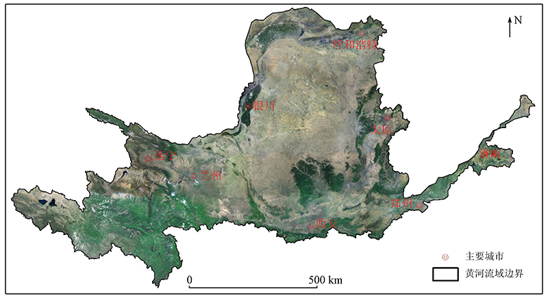
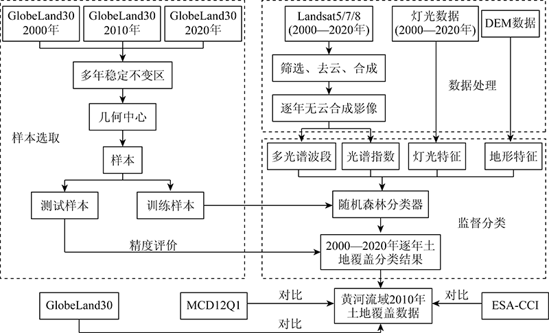
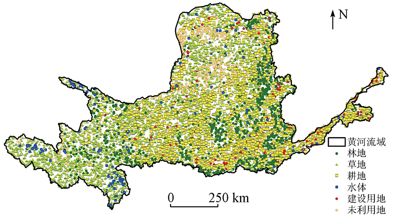
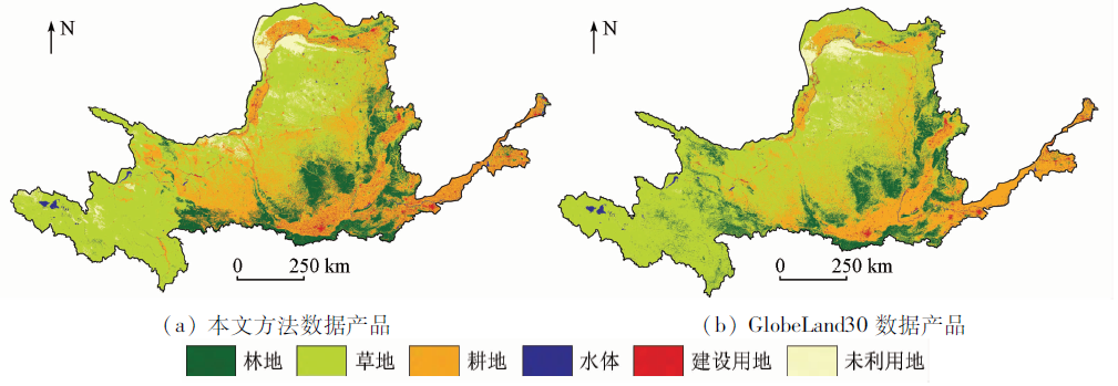
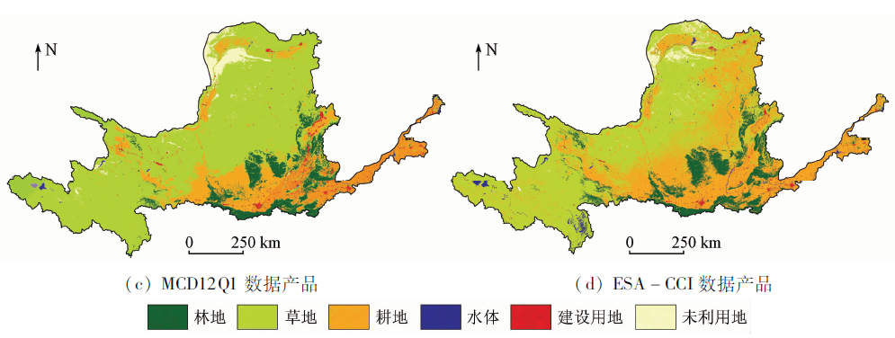
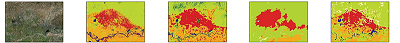
The study on many years’ land cover plays a crucial role in promoting the high-quality development of the Yellow River basin. Meanwhile, high-frequency and high-precision land cover data are vital for land cover monitoring. This study took the basin’s geometric center that has been stable for many years to sample and quickly selected a set of sample points that can be used for annual image supervised classification. Then, cloudless images were screened out from nearly one thousand Landsat images on average of the Yellow River basin of each year from 2000 to 2020 and were spliced by year using Google Earth Engine. Then, the random forest classification method was used to conduct the supervised classification of the cloudless images, producing the annual land cover data of the Yellow River basin in the recent 20 years. Finally, the land cover data of 2010 of the basin were compared with well-known annual land cover data at home and abroad. The results are as follows. ① The selection method of sample points used in this study is reasonable and reliable, with a selection accuracy of more than 94.7%, meeting the requirements of sample accuracy for supervised classification. ② The overall accuracy of the annual land cover data created based on Google Earth Engine is 0.82±0.03, with an average Kappa coefficient of 0.82. The classification accuracy and the overall and local classification results are better than the MCD12Q1 and ESA-CCI datasets. ③ Using the method for creating annual land cover data using Google Earth Engine, the frequency and accuracy of large-scale land cover data can be considered at the same time to a certain extent.

Key wordsGoogle Earth Engine    land cover data    Yellow River basin
收稿日期: 2021-03-26      出版日期: 2022-03-14
ZTFLH:  P962  
基金资助:中国地质调查局项目“南海重要岛礁综合地质遥感调查”编号(DD20208018);“自然资源要素综合观测数据集成与应用服务”编号(DD20208067);“塔里木河流域巴州北部自然资源要素综合观测”共同资助编号(DD20211430)
作者简介: 方梦阳(1992-),男,硕士,助理工程师,主要从事自然资源调查、监测及观测方面的研究。Email: 1311013525@qq.com
引用本文:   
方梦阳, 刘晓煌, 孔凡全, 李明哲, 裴小龙. 一种基于GEE平台制作逐年土地覆盖数据的方法——以黄河流域为例[J]. 自然资源遥感, 2022, 34(1): 135-141.
FANG Mengyang, LIU Xiaohuang, KONG Fanquan, LI Mingzhe, PEI Xiaolong. A method for creating annual land cover data based on Google Earth Engine: A case study of the Yellow River basin. Remote Sensing for Natural Resources, 2022, 34(1): 135-141.
链接本文:  
https://www.gtzyyg.com/CN/10.6046/zrzyyg.2021088      或      https://www.gtzyyg.com/CN/Y2022/V34/I1/135
Fig.1  黄河流域位置
Fig.2  技术流程
CNLUCC分类系统 GlobeLand30数据集分类系统 MCD12Q1数据集
(IGBP分类系统)
ESA-CCI数据集
(LCCS分类系统)
1 耕地 10 耕地 12
14
农田
农田与自然植被镶嵌体
16
17
18
耕地
农田、树木和其他自然植被镶嵌体
农田、灌丛和草本植被镶嵌体
2 林地 20
40
林地
灌木地
1
2
3
4
5
6
7
常绿针叶林
常绿阔叶林
落叶针叶林
落叶阔叶林
混交林
郁闭灌木林
稀疏灌木林
1
2
3
4
5
6
9
10
11
12
常绿阔叶林
郁闭落叶阔叶林
稀疏落叶阔叶林
常绿针叶林
落叶针叶林
针阔混交林
林地和其他自然植被镶嵌体
有林火烧地
常绿灌丛(有/无稀疏树木层)
落叶灌丛(有/无稀疏树木层)
3 草地 30
70
草地
苔原
8
9
10
有林草地
稀树草原
草地
13
14
草本植被
稀疏草本植被或稀疏灌丛
4 水体 50
60
湿地
水体
11
17
永久湿地
水体
7
8
15
20
有林的规律性洪泛区,淡水
有林的规律性洪泛区,咸水
灌丛/草本植被覆盖的规律性洪泛区
水体(自然和人工)
5 建设用地 80 人造地表 13 城镇与建成区 22 人工表面和相关区域
6 未利用地 90
100
裸地
冰川和永久积雪
15
16
冰雪
裸地
19
21
荒地
冰雪(自然和人工)
Tab.1  4类分类体系对应表
Fig.3  样本点分布
土地类型 分类精度
用户精度 制图精度
林地 0.89±0.03 0.90±0.02
草地 0.80±0.04 0.80±0.03
耕地 0.80±0.03 0.81±0.04
水体 0.91±0.03 0.92±0.02
建设用地 0.85±0.04 0.83±0.02
未利用地 0.81±0.05 0.82±0.04
总体精度 0.82±0.03
Tab.2  基于GEE平台黄河流域逐年(2000—2020年)土地覆盖数据分类精度
Fig.4-1  黄河流域2010年土地覆盖分类图
Fig.4-2  黄河流域2010年土地覆盖分类图
地类 本文方法 GlobeLand30 MCD12Q1 ESA-CCI
林地 11.38 9.94 10.65 11.47
草地 59.84 45.53 42.02 35.73
耕地 23.86 24.28 20.11 35.24
水体 1.18 0.95 8.94 2.94
建设用地 0.76 1.80 1.70 1.40
未利用地 2.98 17.50 16.58 13.21
Tab.3  4类数据产品各地类面积占比情况
地类 Google Earth历史影像 本文方法 GlobeLand30 MCD12Q1 ESA-CCI
林地
草地
耕地
水体
建设用地
未利用地
Tab.4  
[1] Friedl M, Sulla-Menashe D. MCD12Q1 MODIS/Terra+Aqua land cover type yearly L3 Global 500 m SIN Grid V006[DB]. NASA EOSDIS Land Processes DAAC, 2019.
[2] Aurélie B. Global ESA CCI land cover classification map (1992—2015)[DB]. A Big Earth Data Platform for Three Poles, 2018.
[3] Friedl M A, McIver D K, Hodges J C F, et al. Global land cover mapping from MODIS:Algorithms and early results[J]. Remote Sensing of Environment, 2002, 83(1/2):287-302.
doi: 10.1016/S0034-4257(02)00078-0
[4] Tsendbazar N E, De Bruin S, Fritz S, et al. Spatial accuracy assessment and integration of global land cover datasets[J]. Remote Sensing, 2015, 7(12):15804-15821.
doi: 10.3390/rs71215804
[5] Chen J, Chen J, Liao A, et al. Remote sensing mapping of global land cover[M]. Beijing: Science Press, 2016.
[6] 徐新良, 刘纪远, 张树文, 等. 中国多时期土地利用土地覆被遥感监测数据集(CNLUCC)[Z]. 中国科学院资源环境科学数据中心数据注册与出版系统, 2018.
Xu X L, Liu J Y, Zhang S W, et al. China multi-period land use land cover remote sensing monitoring data set(CNLUCC)[Z]. Data Registration and Publishing System of the Resource and Environmental Science Data Center of the Chinese Academy of Sciences, 2018.
[7] 宋宏利, 张晓楠. 国家尺度异源土地覆被遥感产品精度评价[J]. 自然资源遥感, 2018, 30(3):26-32.doi: 10.6046/gtzyyg.2018.03.04.
doi: 10.6046/gtzyyg.2018.03.04
Song H L, Zhang X N. Precision validation of multi-sources land cover products derived from remote sensing[J]. Remote Sensing for Land and Resources, 2018, 30(3):26-32.doi: 10.6046/gtzyyg.2018.03.04.
doi: 10.6046/gtzyyg.2018.03.04
[8] Hu Y F, Hu Y. Land cover changes and their driving mechanisms in central Asia from 2001 to 2017 supported by Google Earth Engine[J]. Remote Sensing, 2019, 11(5):554.
doi: 10.3390/rs11050554
[9] Johnson B A, Kotaro I. Integrating OpenStreetMap crowdsourced data and Landsat time-series imagery for rapid land use/land cover (LULC) mapping:Case study of the Laguna de Bay area of the Philippines[J]. Applied Geography, 2016, 67:140-149.
doi: 10.1016/j.apgeog.2015.12.006
[10] Manjunatha V, Nophea S, Rajendra P S, et al. Determination of vegetation thresholds for assessing land use and land use changes in Cambodia using the Google Earth Engine cloud-computing platform[J]. Remote Sensing, 2019, 11(13):1514.
doi: 10.3390/rs11131514
[11] 袁丽华, 蒋卫国, 申文明, 等. 2000—2010年黄河流域植被覆盖的时空变化[J]. 生态学报, 2013, 33(24):7798-7806.
Yuan L H, Jiang W G, Shen W M, et al. The spatio-temporal variations of vegetation cover in the Yellow River basin from 2000 to 2010[J]. Acta Ecologica Sinica, 2013, 33(24):7798-7806.
[12] 杨胜天, 刘昌明, 孙睿. 近20年来黄河流域植被覆盖变化分析[J]. 地理学报, 2002, 57(6):679-684.
Yang S T, Liu C M, Sun R. The vegetation cover over last 20 years in Yellow River basin[J]. Acta Geographica Sinica, 2002, 57(6):679-684.
[13] 张景华, 封志明, 姜鲁光. 土地利用/土地覆被分类系统研究进展[J]. 资源科学, 2011, 33(6):1195-1203.
Zhang J H, Feng Z M, Jiang L G. Progress on studies of land use/land cover classification systems[J]. Resources Science, 2011, 33(6):1195-1203.
[14] 胡云锋, 商令杰, 张千力, 等. 基于GEE平台的1990年以来北京市土地变化格局及驱动机制分析[J]. 遥感技术与应用, 2018, 33(4):573-583.
Hu Y F, Shang L J, Zhang Q L, et al. Land change patterns and driving mechanism in Beijing since 1990 based on GEE platform[J]. Remote Sensing Technology and Application, 2018, 33(4):573-583.
[15] Rodriguez-Galiano V F, Chica-Olmo M, Abarca-Hernandez F, et al. Random forest classification of mediterranean land cover using multi-seasonal imagery and multi-seasonal texture[J]. Remote Sensing of Environment, 2012, 121:93-107.
doi: 10.1016/j.rse.2011.12.003
[16] Guo L, Chehata N, Clément M, et al. Relevance of airborne LiDAR and multispectral image data for urban scene classification using random forests[J]. ISPRS Journal of Photogrammetry and Remote Sensing, 2011, 66(1):56-66.
doi: 10.1016/j.isprsjprs.2010.08.007
[1] 滑永春, 陈家豪, 孙小添, 裴志永. 内蒙古段黄河流域景观生态风险分析[J]. 自然资源遥感, 2023, 35(2): 220-229.
[2] 于森, 贾明明, 陈高, 鲁莹莹, 李毅, 张博淳, 路春燕, 李慧颖. 基于LandTrendr算法海南东寨港红树林扰动研究[J]. 自然资源遥感, 2023, 35(2): 42-49.
[3] 朱琳, 黄玉玲, 杨刚, 孙伟伟, 陈超, 黄可. 基于GEE的杭州湾海岸线遥感提取与时空演变分析[J]. 自然资源遥感, 2023, 35(2): 50-60.
[4] 陈慧欣, 陈超, 张自力, 汪李彦, 梁锦涛. 一种基于Google Earth Engine云平台的潮间带遥感信息提取方法[J]. 自然资源遥感, 2022, 34(4): 60-67.
[5] 李毅, 程丽娜, 鲁莹莹, 张博淳, 于森, 贾明明. 基于最大值合成和最大类间方差法莱州湾滨海滩涂变化研究[J]. 自然资源遥感, 2022, 34(4): 68-75.
[6] 朱琦, 郭华东, 张露, 梁栋, 刘栩婷, 万祥星. 基于多时相Landsat8影像的海南岛热带天然林类型遥感分类[J]. 自然资源遥感, 2022, 34(2): 215-223.
[7] 郑修诚, 周斌, 雷惠, 黄祺宇, 叶浩林. 基于GEE的杭州湾慈溪段潮滩提取及时空变化分析[J]. 自然资源遥感, 2022, 34(1): 18-26.
[8] 姚金玺, 张志, 张焜. 基于GEE的诺木洪洪积扇植被时空变化特征、成因及趋势分析[J]. 自然资源遥感, 2022, 34(1): 249-256.
[9] 赖佩玉, 黄静, 韩旭军, 马明国. 基于GEE的三峡蓄水对重庆地表水和植被影响研究[J]. 自然资源遥感, 2021, 33(4): 227-234.
[10] 杨雯娜, 周亮, 孙东琪. 基于分区-集成的黄河流域生态脆弱性评价[J]. 自然资源遥感, 2021, 33(3): 211-218.
[11] 牟晓莉, 李贺, 黄翀, 刘庆生, 刘高焕. Google Earth Engine在土地覆被遥感信息提取中的研究进展[J]. 国土资源遥感, 2021, 33(2): 1-10.
[12] 陈虹, 郭兆成, 贺鹏. 1988—2018年间洱海流域植被覆盖度时空变换特征探究[J]. 国土资源遥感, 2021, 33(2): 116-123.
[13] 叶婉桐, 陈一鸿, 陆胤昊, 吴鹏海. 基于GEE的2000—2019年间升金湖湿地不同季节地表温度时空变化及地表类型响应[J]. 国土资源遥感, 2021, 33(2): 228-236.
[14] 孙波, 孙永军, 田垄. 黄淮海流域湿地遥感调查[J]. 国土资源遥感, 2010, 22(s1): 144-147.
[15] 李晓琴, 田垄, 余珍风. 黄河流域水土流失遥感监测[J]. 国土资源遥感, 2009, 21(4): 57-61.
Viewed
Full text


Abstract

Cited

  Shared   
  Discussed   
京ICP备05055290号-2
版权所有 © 2015 《自然资源遥感》编辑部
地址:北京学院路31号中国国土资源航空物探遥感中心 邮编:100083
电话:010-62060291/62060292 E-mail:zrzyyg@163.com
本系统由北京玛格泰克科技发展有限公司设计开发