A GEE-based study on the temporal and spatial variations in the carbon source/sink function of vegetation in the Three-River Headwaters region
ZHANG Zhenqi1(), CAI Huiwen1,2(), ZHANG Pingping1, WANG Zelin1, LI Tingting2
1. College of Marine Science and Technology, Zhejiang Ocean University, Zhoushan 316022, China 2. NationalEngineering Research Center of Marine Aquaculture, Zhoushan 316022, China
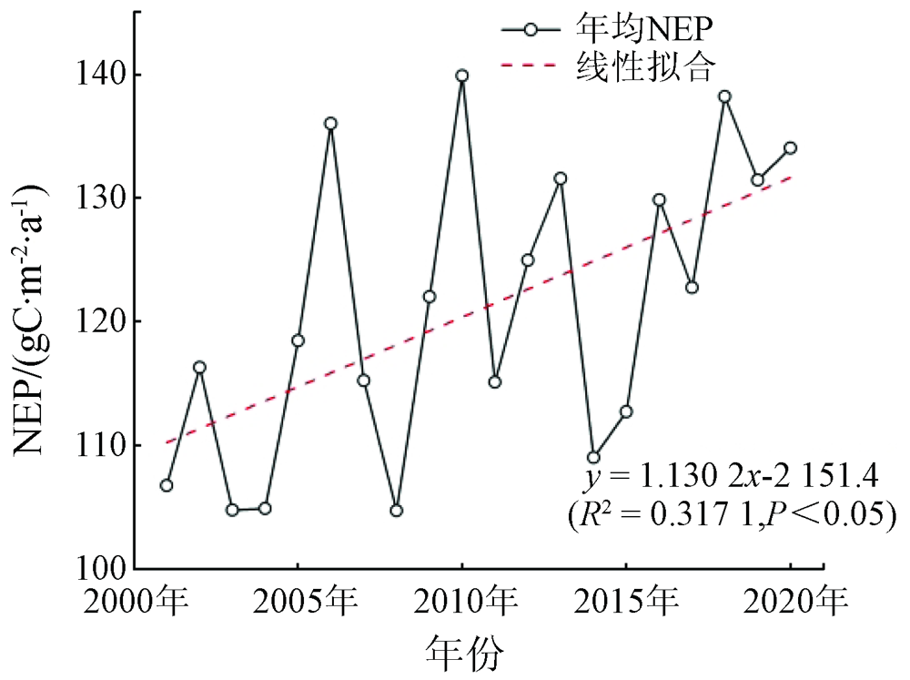
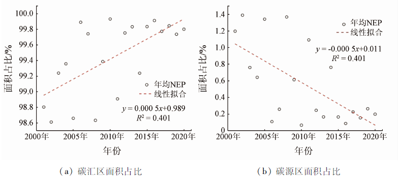
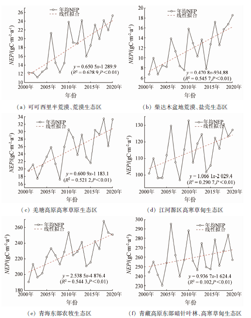
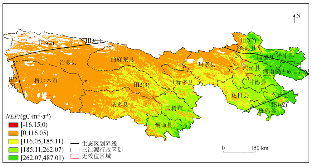
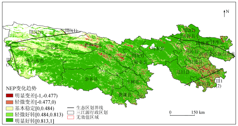
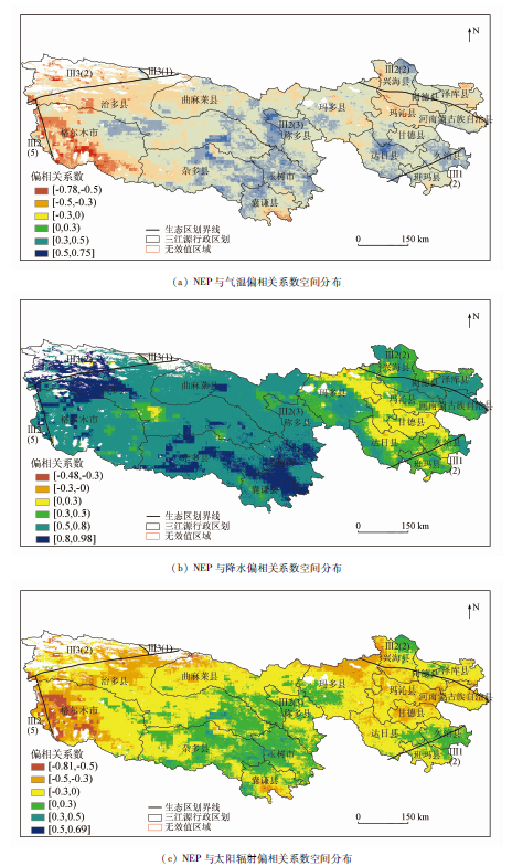
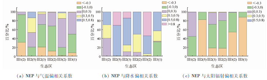
Net ecosystem productivity (NEP) represents the carbon sequestration capacity of a regional ecosystem. Based on the Google Earth Engine (GEE) platform, this study analyzed the temporal and spatial variations in the NEP of the Three-River Headwaters Region (TRHR) from 2001 to 2020 based on the Moderate Resolution Imaging Spectrometer (MODIS) and meteorological data and revealed their relationships with climate factors. The results are as follows: ① The TRHR had an important carbon sink function, with carbon sink areas accounting for 99.89%; The carbon source areas in the TRHR were primarily distributed in the northwest, accounting for only 0.11%. The NEP of the TRHR decreased gradually from the southeast to the northwest and differed significantly among different ecological areas; ② The NEP of the TRHR showed an upward trend overall in the past 20 years, with an annual increasing rate of 1.13 gC/(m2·a), indicating huge carbon sequestration potential; ③ The area of zones whose NEP showed an upward trend accounted for 95.05% of the total area. Ecological engineering construction significantly improved the NEP of vegetation. As a result, the carbon sink function gradually increased and was highly stable; ④ The TRHR had an annual average NEP of 120.93 gC/(m2·a), and the NEP was positively correlated with the annual precipitation but negatively correlated with average annual temperature and annual solar radiation. The warm, humid climate and the ecological engineering construction contributed to the carbon sink function of vegetation in the TRHR. This is of great significance for improving the carbon sink value of the terrestrial ecosystem and achieving the peak carbon dioxide emissions and carbon neutrality of China.
张祯祺, 蔡惠文, 张平平, 王泽琳, 李婷婷. 基于GEE遥感云平台的三江源植被碳源/汇时空变化研究[J]. 自然资源遥感, 2023, 35(1): 231-242.
ZHANG Zhenqi, CAI Huiwen, ZHANG Pingping, WANG Zelin, LI Tingting. A GEE-based study on the temporal and spatial variations in the carbon source/sink function of vegetation in the Three-River Headwaters region. Remote Sensing for Natural Resources, 2023, 35(1): 231-242.
Keenan T F, Prentice I C, Canadell J G, et al. Recent pause in the growth rate of atmospheric CO2 due to enhanced terrestrial carbon uptake[J]. Nature Communications, 2016, 7:13428.
doi: 10.1038/ncomms13428
Tang X Y, Wu H, Dong J W, et al. Effects of desertification and degradation on carbon sequestration of grassland ecosystem in Gannan[J]. Chinese Journal of Ecology, 2022, 41(2):278-286.
Yang Y H, Shi Y, Sun W J, et al. Terrestrial carbon sinks in China and around the world and their contribution to carbon neutrality[J]. Scientia Sinica(Vitae), 2022, 52(4):534-574.
[4]
Woodwell G M, Whitaker R H, Reiners W A, et al. The biota and the world carbon budget[J]. Science, 1978, 199:141-146.
pmid: 17812932
Liu M X, Jiao J, Pan J H, et al. Spatial and temporal patterns of planting NPP and its driving factors in Qinghai Province[J]. Acta Ecologica Sinica, 2020, 40(15):5306-5317.
Chen X J, Zhou W, Y H. Simulation and dynamic change of carbon source/sink in the typical grassland communities in the Three River Source area from 2001 to 2017[J]. Arid Land Geography, 2020, 43(6):1583-1592.
[7]
王苗苗. 三江源区高寒草甸草产量遥感监测及植物碳汇动态研究[D]. 兰州: 兰州大学, 2011.
Wang M M. Study of the alpine meadow yield monitoring and the dynamic of vegetation carbon sequestration in the source region of Yangtze,Yellow and Lancang Rivers[D]. Lanzhou: Lanzhou University, 2011.
Zheng F G, Yi G H, Zhang T B, et al. Study on spatio-temporal dynamics of vegetation carbon use efficiency and its response to climate factors in Three-River Headwaters region[J]. China Environmental Science, 2020, 40(1):401-413.
[9]
苏淑兰. 三江源草地生态系统碳储量及其影响因素[D]. 兰州: 兰州大学, 2015.
Su S L. Carbon storage and its influencing factors of the grassland in Three River Sources Region[D]. Lanzhou: Lanzhou University, 2015.
Zhang J P, Liu C L, Hao H G, et al. Spatial-temporal change of carbon storage and carbon sink of grassland ecosystem in the Three-River Headwaters region based on MODIS GPP/NPP data[J]. Ecology and Environmental Sciences, 2015, 24(1):8-13.
Lu Q L, Li Y H. Study on carbon storage and carbon density of forest vegetation in Sanjiangyuan Nature Reserve[J]. Forest Resources Management, 2018(4):146-153.
[12]
李宗洮. 青海三江源地区农业碳排放影响因素及减排对策研究[D]. 西宁: 青海大学, 2020.
Li Z T. Study on factors affecting agricultural carbon emission and countermeasures for emission reduction in Sanjiangyuan region of Qinghai[D]. Xining: Qinghai University, 2020.
Ren X L, He H L, Zhang L, et al. Net ecosystem production of alpine grasslands in the Three-River Headwaters region during 2001—2010[J]. Research of Environmental Sciences, 2017, 30(1):51-58.
[14]
Long T, Zhang Z, He G, et al. 30 m resolution global annual burned area mapping based on Landsat images and Google Earth Engine[J]. Remote Sensing, 2019, 11(5): 489.
doi: 10.3390/rs11050489
Chen W, Huang H P, Tian Y C, et al. Monitoring and assessment of the eco-environment quality in the Sanjiangyuan region based on Google Earth Engine[J]. Journal of Geo-Information Science, 2019, 21(9):1382-1391.
[16]
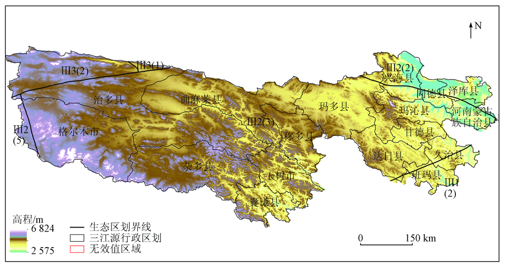
傅伯杰, 刘国华, 陈利顶, 等. 中国生态区划方案[J]. 生态学报, 2001(1):1-6.
Fu B J, Liu G H, Chen L D, et al. Scheme of ecological regionalization in China[J]. Acta Ecologica Sinica, 2001(1):1-6.
Zheng X C, Zhou B, Li H, et al. Extraction and spatio-temporal change analysis of the tidal flat in Cixi section of Hangzhou Bay based on Google Earth Engine[J]. Remote Sensing for Natural Resources, 2022, 34(1):18-26.doi: 10.6046/zrzyyg.2022021.
doi: 10.6046/zrzyyg.2022021
Dai E F, Huang Y, Wu Z, et al. Spatial-temporal features of carbon source-sink and its relationship with climate factors in Inner Mongolia grassland ecosystem[J]. Acta Geographica Sinica, 2016, 71(1):21-34.
doi: 10.11821/dlxb201601002
Gong J, Zhang Y, Qian C Y. Temporal and spatial distribution of net ecosystem productivity in the Bailongjiang Watershed of Gansu Province[J]. Acta Ecologica Sinica, 2017, 37(15):5121-5128.
Zhou X F, Yu F, Cao G Z, et al. Spatiotemporal features of carbon source-sink and its relationship with climate factors in Qinghai-Tibet Plateau grassland ecosystem during 2001—2015[J]. Research of Soil and Water Conservation, 2019, 26(1):76-81.
[21]
Pei Z Y, Ouyang H, Zhou C P, et al. Carbon balance in an alpine steppe in the Qinghai-Tibet Plateau[J]. Journal of Integrative Plant Biology, 2009, 51(5):521-526.
doi: 10.1111/jipb.2009.51.issue-5
Pan J H, Wen Y. Estimation and spatial-temporal characteristics of carbon sink in the arid region of northwest China[J]. Acta Ecologica Sinica, 2015, 35(23):7718-7728.
Zhang L, Wang J, Shi R H. Temporal-spatial variations of carbon sink / source in Northeast China from 2000 to 2010[J]. Journal of East China Normal University(Natural Science), 2015(4):164-173.
Tong X W, Wang K L, Yue Y M, et al. Trends in vegetation and their responses to climate and topography in northwest Guangxi[J]. Acta Ecologica Sinica, 2014, 34(12):3425-3434.
Liu Y B, Liu B Y, Cheng C, et al. Spatio-temporal changes and influencing factors of vegetation coverage in Yulin city during the past 20 years since the implementation of the “Grain for Green” Program[J]. Journal of Soil and Water Conservation, 2022, 36(2):197-208,218.
Feng X H, Zeng Z L, Zhang D S. Temporal-spatial evolution of vegetation coverage in Guangdong-HongKong-Macao Greater Bay Area based on MODIS NDVI data[J]. Journal of Chinese Urban Forestry, 2022, 20(1):1-6,28.
Zhang L, Jiang J. Temporal and spatial variation characteristics of surface vegetation and its relationship with environmental factors based on MODIS-NDVI[J]. Journal of Anhui Agricultural Sciences, 2022, 50(4):57-63.
Fan W W. Analysis of NDVI changes and its climate driving factors in the Three River-Headwater region during 2000—2014[D]. Chengdu: Chengdu University of Technology, 2017.
Zhang C, Li Q, Li Z F. Influence of human activities on variation of vegetation cover in the Three-River Source region[J]. China Population,Resources and Environment, 2014, 24(5):139-144.
Shao Q Q, Liu J Y, H L, et al. Integrated assessment on the effectiveness of ecological conservation in Sanjiangyuan National Nature Reserve[J]. Geographical Research, 2013, 32(9):1645-1656.
doi: 10.11821/dlyj201309007
Li F, Xu W X. Spatial and temporal variation of NDVl in different functional areas of Qinghai from 2000 to 2015[J]. Acta Agrestia Sinica, 2017, 25(4):701-710.
Li H X, Liu G H, Fu B J. Response of vegetation to climate change and human activity based on NDVl in the Three-River Headwaters region[J]. Acta Ecologica Sinica, 2011, 31(19):5495-5504.
Liu X F, Ren Z Y, Lin Z H, et al. The spatial-temporal changes of vegetation coverage in the Three-River Headwater region in recent 12 years[J]. Acta Geographica Sinica, 2013, 68(7):897-908.
[34]
Shi P J, Sun S, Wang M, et al. Climate change regionalization in China (1961—2010)[J]. Science China Earth Sciences, 2014, 57(11): 2676-2689.
doi: 10.1007/s11430-014-4889-1
[35]
Bao G, Bao Y H, Sanjjava A, et al. NDVI-indicated long-term vegetation dynamics in Mongolia and their response to climate change at biome scale[J]. International Journal of Climatology, 2015, 35(14): 4293-4306.
doi: 10.1002/joc.4286
[36]
Sun J, Zhou T C, Liu M, et al. Water and heat availability are drivers of the aboveground plant carbon accumulation rate in alpine grasslands on the Tibetan Plateau[J]. Global Ecology and Biogeography, 2020, 29(1): 50-64.
doi: 10.1111/geb.v29.1
[37]
Zhang X L, Tan Y L, Li A, et al. Water and nitrogen availability co-control ecosystem CO2 exchange in a semiarid temperate steppe[J]. Scientific Reports, 2015, 5:15549.
doi: 10.1038/srep15549
[38]
Zhang X L, Tan Y L, Zhang B W, et al. The impacts of precipitation increase and nitrogen addition on soil respiration in a semiarid temperate steppe[J]. Ecosphere, 2017, 8(1):e01655.
doi: 10.1002/ecs2.1655
Zhang X L, Zhai P H, Huang J H. Advances in the influences of precipitation and nitrogen deposition change on the carbon cycle of grassland ecosystem[J]. Acta Agrestia Sinica, 2018, 26(2):284-288.
Chen C, Wang Y M, Li Y Y, et al. Vegetation changes and influencing factors in different climatic regions of Yellow River basin from 1982 to 2015[J]. Journal of Yangtze River Scientific Research Institute, 2022, 39(2):56-62,81.
Jia J H, Liu H Y, Lin Z S. Multi-time scale changes of vegetation NPP in six provinces of northwest China and their responses to climate change[J]. Acta Ecologica Sinica, 2019, 39(14):5058-5069.
Shang S S, Lian L S, Ma T, et al. Spatiotemporal variation of temperature and precipitation in northwest China in recent 54 years[J]. Arid Zone Research, 2018, 35(1):68-76.
 2023, Vol. 35
  ), 蔡惠文1,2(