Please wait a minute...
 
自然资源遥感  2021, Vol. 33 Issue (4): 219-226    DOI: 10.6046/zrzyyg.2020403
  技术应用 本期目录 | 过刊浏览 | 高级检索 |
遥感技术在中尼铁路工程地质勘察中的应用
陈富强(), 刘亚林(), 高旭, 宋明辉, 张占忠
中铁第一勘察设计院集团有限公司,西安 710043
Application of remote sensing technology to the engineering geological survey for the construction of the China-Nepal railway
CHEN Fuqiang(), LIU Yalin(), GAO Xu, SONG Minghui, ZHANG Zhanzhong
China Railway First Survey and Design Institute Group Co., Ltd., Xi’an 710043, China
全文: PDF(5876 KB)   HTML  
输出: BibTeX | EndNote (RIS)      
摘要 

中尼铁路作为世界上首条穿越喜马拉雅山脉的铁路工程,面临着高海拔、高落差、高寒气候、地震活动带、软岩变形、不良地质发育等诸多环境、地质问题,线路方案的设计、选择明显受地质条件的约束,需要彻底摸清区内各类地质问题。为了克服地表调查的局限性、减轻外业调查工作量、提高工作效率,文章充分发挥遥感技术特长,在分析已有基础地质、工程地质、地质环境等资料的基础上,采用多源遥感技术,对研究区内的地形地貌、地层岩性、地质构造、水文地质、滑坡、泥石流、风沙等不良地质要素开展了详细的解译分析,为工程地质调查以及线路方案设计、选线提供了较详细、全面、可靠的遥感成果资料,发挥了重要的技术支撑作用。

服务
把本文推荐给朋友
加入引用管理器
E-mail Alert
RSS
作者相关文章
陈富强
刘亚林
高旭
宋明辉
张占忠
关键词 中尼铁路地质解译工程地质滑坡泥石流    
Abstract

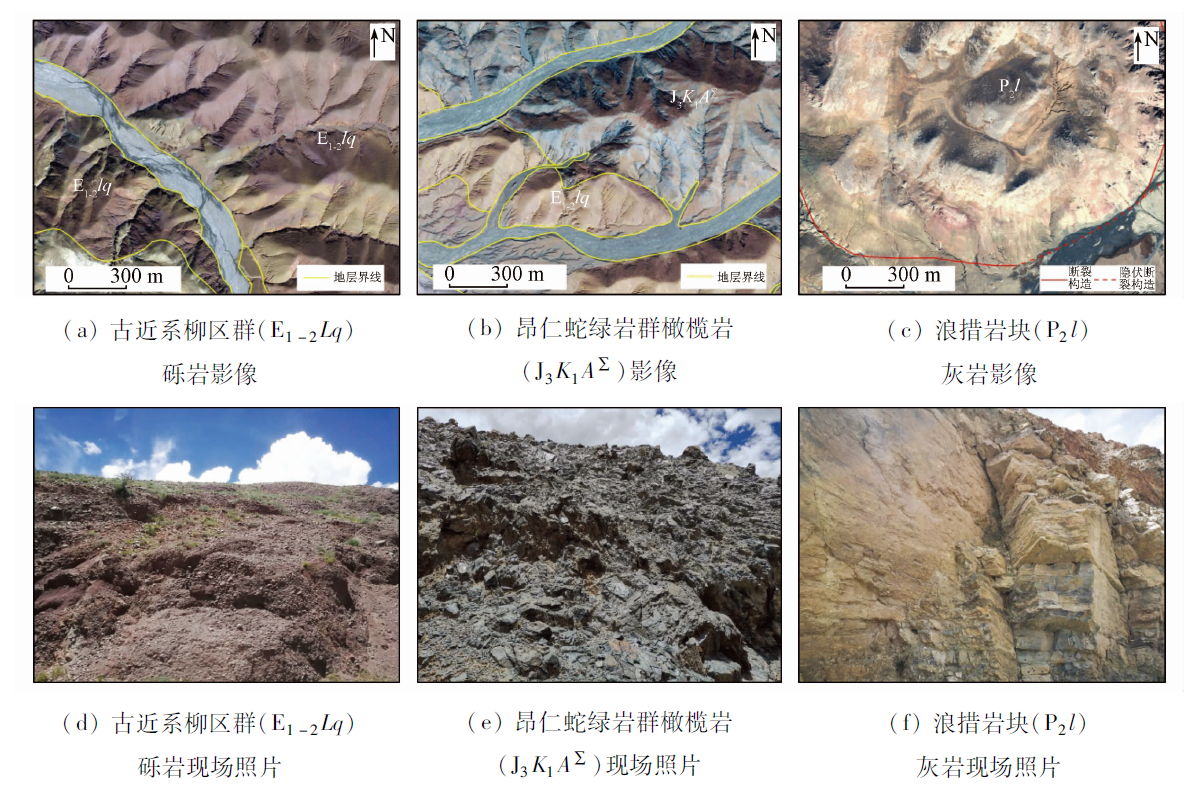
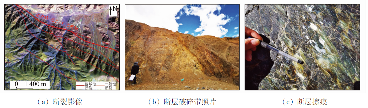
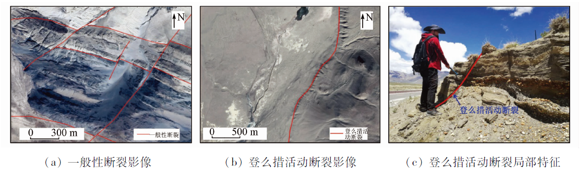
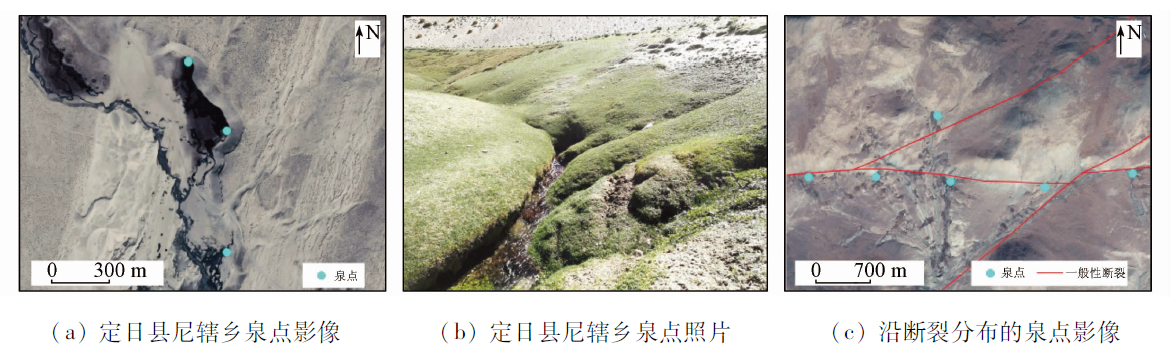
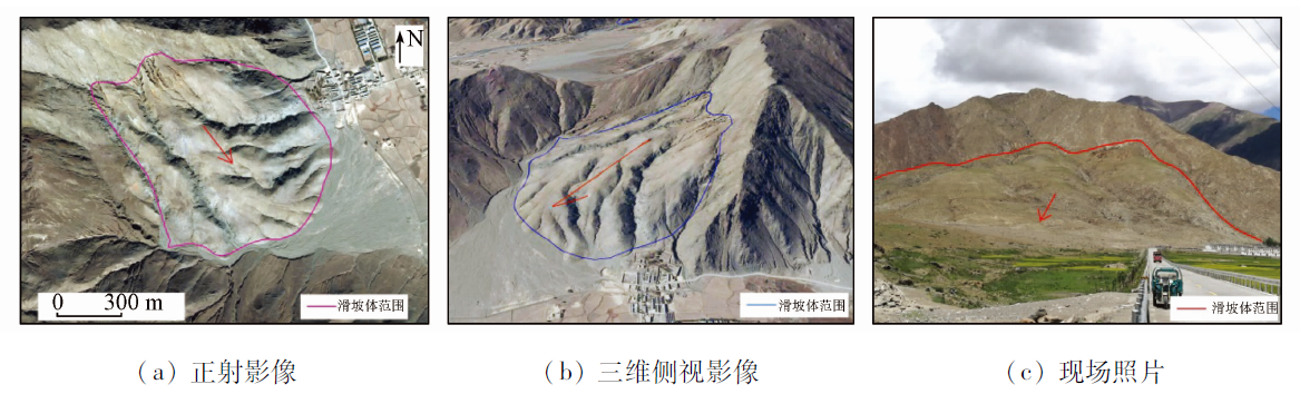
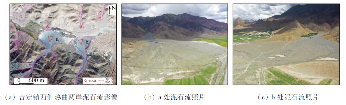
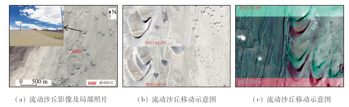
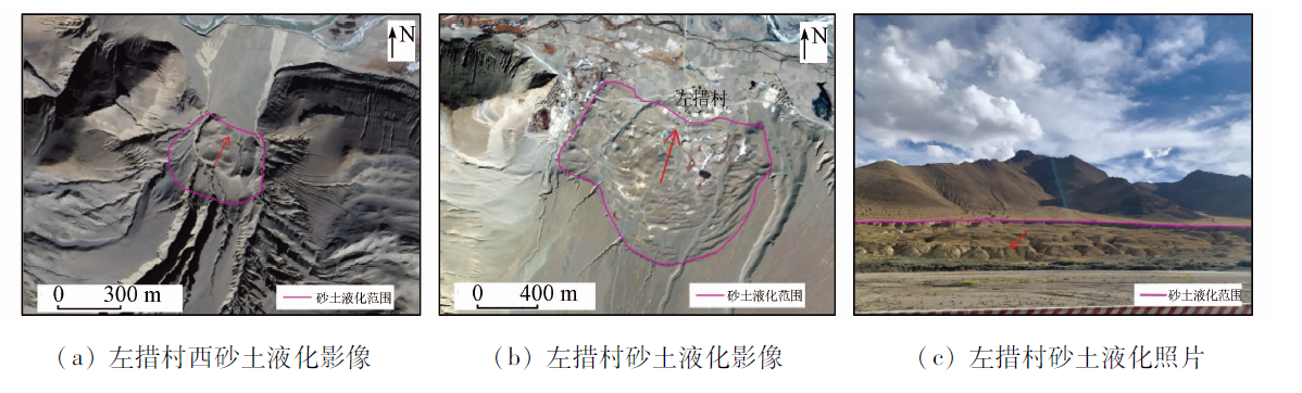
As the first railway project crossing the Himalayas in the world, the construction of the China-Nepal railway is confronted with many environmental and geological problems such as high elevation, a big difference in elevation, alpine climate, seismic activity zones, soft-rock deformation, and geological disasters. Since the design and selection of route schemes of the railway line are notably restricted by geological conditions, it is necessary to thoroughly understand various geological problems in the study area. This study gives full play to the remote sensing technique to overcome the limitations of surface surveys, reduce the workload of field surveys, and improve work efficiency. Based on the analyses of existing data on basic geology, engineering geology, and geological environment, this study uses the multi-source remote sensing technique to conduct a detailed interpretation and analysis of the adverse geological elements in the study area, including terrain, landform, stratigraphic lithology, geological structures, hydrogeology, landslides, debris flow, and wind-blown sand. In this way, it provides detailed, comprehensive, and reliable remote sensing data for the engineering geological survey and the route design and selection of the China-Nepal railway and plays an important role in technical support.

Key wordsChina-Nepal railway    geological interpretation    engineering geology    landslide    debris flow
收稿日期: 2020-12-14      出版日期: 2021-12-23
ZTFLH:  TP79  
基金资助:铁一院科技研究项目“铁路勘察设计基础地理信息数据库建设”(院科19-88)
通讯作者: 刘亚林
作者简介: 陈富强(1989-),男,硕士,工程师,研究方向为遥感技术应用研究。Email: cfq531992@126.com
引用本文:   
陈富强, 刘亚林, 高旭, 宋明辉, 张占忠. 遥感技术在中尼铁路工程地质勘察中的应用[J]. 自然资源遥感, 2021, 33(4): 219-226.
CHEN Fuqiang, LIU Yalin, GAO Xu, SONG Minghui, ZHANG Zhanzhong. Application of remote sensing technology to the engineering geological survey for the construction of the China-Nepal railway. Remote Sensing for Natural Resources, 2021, 33(4): 219-226.
链接本文:  
https://www.gtzyyg.com/CN/10.6046/zrzyyg.2020403      或      https://www.gtzyyg.com/CN/Y2021/V33/I4/219
Fig.1  部分地层岩性单元影像特征及现场照片
(图1(a),(b),(c)为WorldView-2 B3(R),B2(G),B1(B)波段合成影像)
Fig.2  达吉岭—昂仁—仁布断裂影像特征及现场照片
Fig.3  一般性断裂影像及登么措活动断裂影像及照片
Fig.4  泉点影像及照片
Fig.5  吉堆滑坡影像及照片
Fig.6  泥石流影像及现场照片
Fig.7  流动沙丘影像
Fig.8  砂土液化影像及现场照片
[1] 童立强, 聂洪峰, 李建存, 等. 喜马拉雅山地区大型泥石流遥感调查与发育特征研究[J]. 国土资源遥感, 2013,25(4):104-112.doi: 10.6046/gtzyyg.2013.04.17.
doi: 10.6046/gtzyyg.2013.04.17
Tong L Q, Nie H F, Li J C, et al. Survey of large-scale debris flow and study of its development characteristics using remote sensing technology in the Himalayas[J]. Remote Sensing for Land and Resources, 2013,25(4):104-112.doi: 10.6046/gtzyyg.2013.04.17.
doi: 10.6046/gtzyyg.2013.04.17
[2] 刘桂卫, 郭晓亮. 遥感技术在浦梅线地质勘察中应用研究[J]. 铁道工程学报, 2016,33(12):9-13,23.
Liu G W, Guo X L. Application of remote sensing technology for geological investigation in Pucheng-Meizhou Railway[J]. Journal of Railway Engineering Society, 2016,33(12):9-13,23.
[3] 陈富强, 邓国仕, 姬星怡, 等. 遥感技术在川西螺髻山地区水文地质环境调查中的应用[J]. 国土资源遥感, 2019,31(4):209-217.doi: 10.6046/gtzyyg.2019.04.27.
doi: 10.6046/gtzyyg.2019.04.27
Chen F Q, Deng G S, Ji X Y, et al. Application of remote sensing technology to hydrogeological environment survey in the Luoji Mountain area,western Sichuan Province[J]. Remote Sensing for Land and Resources, 2019,31(4):209-217.doi: 10.6046/gtzyyg.2019.04.27.
doi: 10.6046/gtzyyg.2019.04.27
[4] 余绍淮, 陈楚江, 张霄. 基于遥感技术的中吉乌铁路地质构造分析[J]. 铁道工程学报, 2015,32(5):12-17.
Yu S H, Chen C J, Zhang X. Analysis of the geological structure for China-Kyrgyzstan-Uzbekistan Railway based on remote sensing[J]. Journal of Railway Engineering Society, 2015,32(5):12-17.
[5] 李晓民, 张焜, 李冬玲, 等. 青藏高原札达地区多年冻土遥感技术圈定方法与应用[J]. 国土资源遥感, 2017,29(1):57-64.doi: 10.6046/gtzyyg.2017.01.09.
doi: 10.6046/gtzyyg.2017.01.09
Li X M, Zhang K, Li D L, et al. Remote sensing technology delineation method and its application to permafrost of Zha da area in the Tibetan Plateau[J]. Remote Sensing for Land and Resources, 2017,29(1):57-64.doi: 10.6046/gtzyyg.2017.01.09.
doi: 10.6046/gtzyyg.2017.01.09
[6] 孟祥连, 周福军. 真实感场景遥感技术在铁路工程勘察中的应用[J]. 西南交通大学学报, 2017,52(5):949-955.
Meng X L, Zhou F J. Application of railway engineering survey based on remote sensing technology for realistic scenes[J]. Journal of Southwest Jiaotong University, 2017,52(5):949-955.
[7] 刘桂卫. 多尺度三维遥感技术在某铁路地质勘察中应用[J]. 铁道工程学报, 2016,33(8):40-43,99.
Liu G W. Application of multi-scale 3D remote sensing technology for geological investigation in railway[J]. Journal of Railway Engineering Society, 2016,33(8):40-43,99.
[8] 张占忠. 铁路大场景立体影像模型制作关键技术及应用[J]. 铁道工程学报, 2020,37(4):11-16.
Zhang Z Z. Key technologies for making large scene stereo model and its application in railway survey and design[J]. Journal of Railway Engineering Society, 2020,37(4):11-16.
[9] 吕希奎, 陈进杰. 铁路数字化选线三维地质环境建模方法[J]. 铁道学报, 2015,37(8):91-97.
Lyu X K, Chen J J. Three-dimensional geological environment modeling method for digital railway alignment[J]. Journal of The China Railway Society, 2015,37(8):91-97.
[10] 孙先锋. 中尼铁路沿线活动断裂对地质选线的影响浅析[J]. 铁道标准设计, 2019,63(3):44-48.
Sun X F. An analysis of the effect of the active faults along the China-Nepal Railway on the geological route selection[J]. Railway Standard Design, 2019,63(3):44-48.
[11] 黄艺丹, 姚令侃, 谭礼, 等. 喜马拉雅造山带工程效应及中尼铁路工程地质分区[J]. 工程地质学报, 2020,28(2):421-430.
Huang Y D, Yao L K, Tan L, et al. Engineering effect of the Himalayan orogen and engineering geological zoning of China-Nepal Railway[J]. Journal of Engineering Geology, 2020,28(2):421-430.
[12] 潘桂棠, 肖庆辉, 陆松年 等. 中国大地构造单元划分[J]. 中国地质, 2009,36(1):1-16,255,17-28.
Pan G T, Xiao Q H, Lu S N, et al. Subdivision of tectonic units in China[J]. Geology in China, 2009,36(1):1-16,255,17-28.
[13] 马建军, 潘美慧, 伍永秋, 等. 1996—2016年西藏定结地区风沙地貌格局与变化[J]. 干旱区地理, 2018,41(5):1035-1042.
Ma J J, Pan M H, Wu Y Q, et al. Geomorphological pattern and its change of aeolian landform in Dingjie area of Tibet from 1996 to 2016[J]. Arid Land Geography, 2018,41(5):1035-1042.
[1] 李晨辉, 郝利娜, 许强, 王一, 严丽华. 面向对象的高分辨率遥感影像地震滑坡分层识别[J]. 自然资源遥感, 2023, 35(1): 74-80.
[2] 张雨, 明冬萍, 赵文祎, 徐录, 赵治, 刘冉. 基于高分光学卫星影像的泸定地震型滑坡提取与分析[J]. 自然资源遥感, 2023, 35(1): 161-170.
[3] 贺鹏, 颜瑜严, 文艳, 马志刚, 焦其松, 郭兆成, 莫悠. 机载LiDAR技术在缓倾地层滑坡及其拉裂槽识别中的应用[J]. 自然资源遥感, 2022, 34(4): 307-316.
[4] 董继红, 马志刚, 梁京涛, 刘彬, 赵聪, 曾帅, 鄢圣武, 马晓波. 基于时序InSAR技术的滑坡隐患识别对比研究[J]. 自然资源遥感, 2022, 34(3): 73-81.
[5] 刘亚林. 基于真实感场景影像的天陇铁路勘察遥感解译与分析[J]. 自然资源遥感, 2022, 34(3): 227-234.
[6] 杨昭颖, 韩灵怡, 郑向向, 李文吉, 冯磊, 王轶, 杨永鹏. 基于卷积神经网络的遥感影像及DEM滑坡识别——以黄土滑坡为例[J]. 自然资源遥感, 2022, 34(2): 224-230.
[7] 刘志中, 宋英旭, 叶润青. 渝东北2014年“8·31”暴雨诱发滑坡遥感解译与分析[J]. 自然资源遥感, 2021, 33(4): 192-199.
[8] 魏英娟, 刘欢. 北衙金矿床遥感矿化蚀变信息提取及找矿预测[J]. 自然资源遥感, 2021, 33(3): 156-163.
[9] 凌晓, 刘甲美, 王涛, 朱月琴, 袁玲玲, 陈扬洋. 基于致灾因子对称法分级的信息量模型在地震滑坡危险性评价中的应用[J]. 国土资源遥感, 2021, 33(2): 172-181.
[10] 张腾, 谢帅, 黄波, 范景辉, 陈建平, 童立强. 利用Sentinel-1和ALOS-2数据探测茂县中部活动滑坡[J]. 国土资源遥感, 2021, 33(2): 213-219.
[11] 陈洁, 蔡君, 李京, 贺鹏. 倾斜航空摄影技术及在地质调查中的应用研究——以三峡库区巫峡地区为例[J]. 国土资源遥感, 2021, 33(1): 167-173.
[12] 闫驰, 焦润成, 曹颖, 南赟, 王晟宇, 郭学飞. 无人机倾斜摄影在泥石流灾害识别分析中的应用——以北京房山区史家营曹家坊泥石流为例[J]. 国土资源遥感, 2020, 32(4): 251-257.
[13] 贾伟洁, 王治华. 基于高分辨率遥感影像的滑坡活动特征及稳定性分析——以东苗家滑坡为例[J]. 国土资源遥感, 2019, 31(4): 174-181.
[14] 陈富强, 邓国仕, 姬星怡, 张云峰, 焦超卫, 冯淳. 遥感技术在川西螺髻山地区水文地质环境调查中的应用[J]. 国土资源遥感, 2019, 31(4): 209-217.
[15] 王振林, 廖明生, 张路, 罗恒, 董杰. 基于时序Sentinel-1数据的锦屏水电站左岸边坡形变探测与特征分析[J]. 国土资源遥感, 2019, 31(2): 204-209.
Viewed
Full text


Abstract

Cited

  Shared   
  Discussed   
京ICP备05055290号-2
版权所有 © 2015 《自然资源遥感》编辑部
地址:北京学院路31号中国国土资源航空物探遥感中心 邮编:100083
电话:010-62060291/62060292 E-mail:zrzyyg@163.com
本系统由北京玛格泰克科技发展有限公司设计开发