Multi-feature fusion-based recognition and processing of impulse noise in remote sensing images
MA Xiaojian1(), ZHAO Fashun1, LIU Yanbin2
1. College of Science, Northeast Forestry University, Harbin 150040, China 2. School of Earth Sciences and Resources, China University of Geosciences(Beijing), Beijing 100083, China
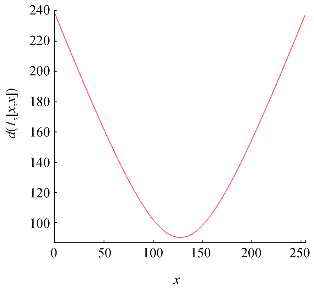
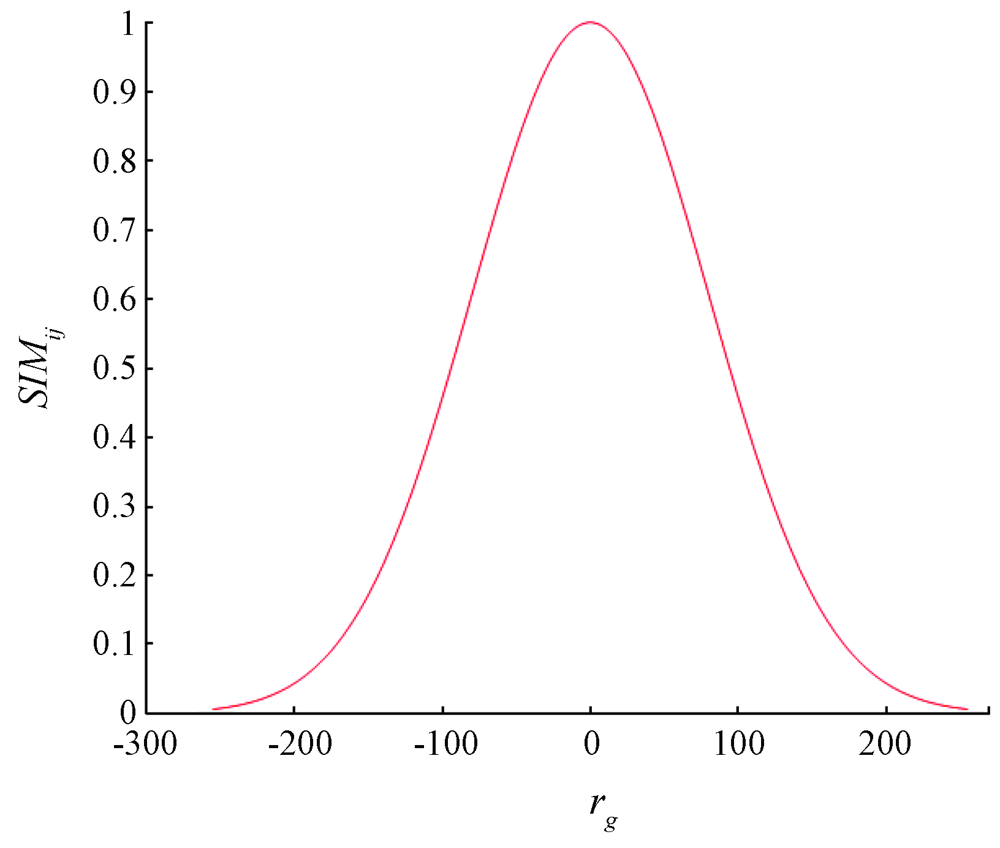
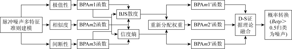
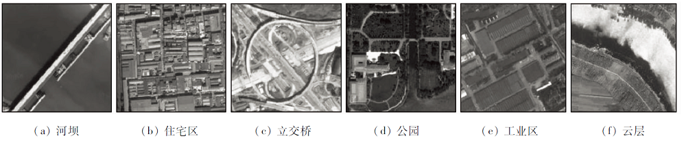
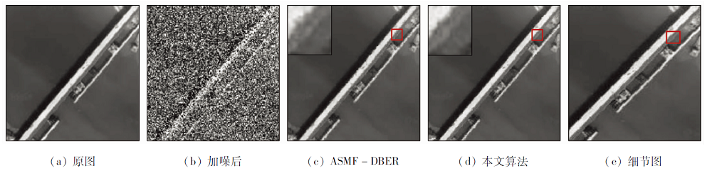
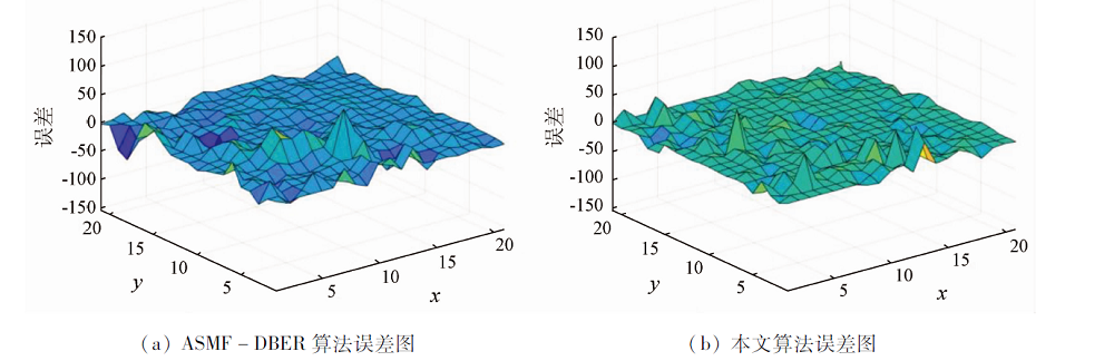
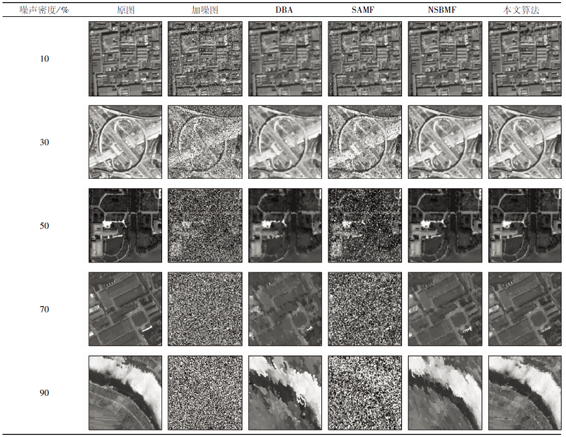
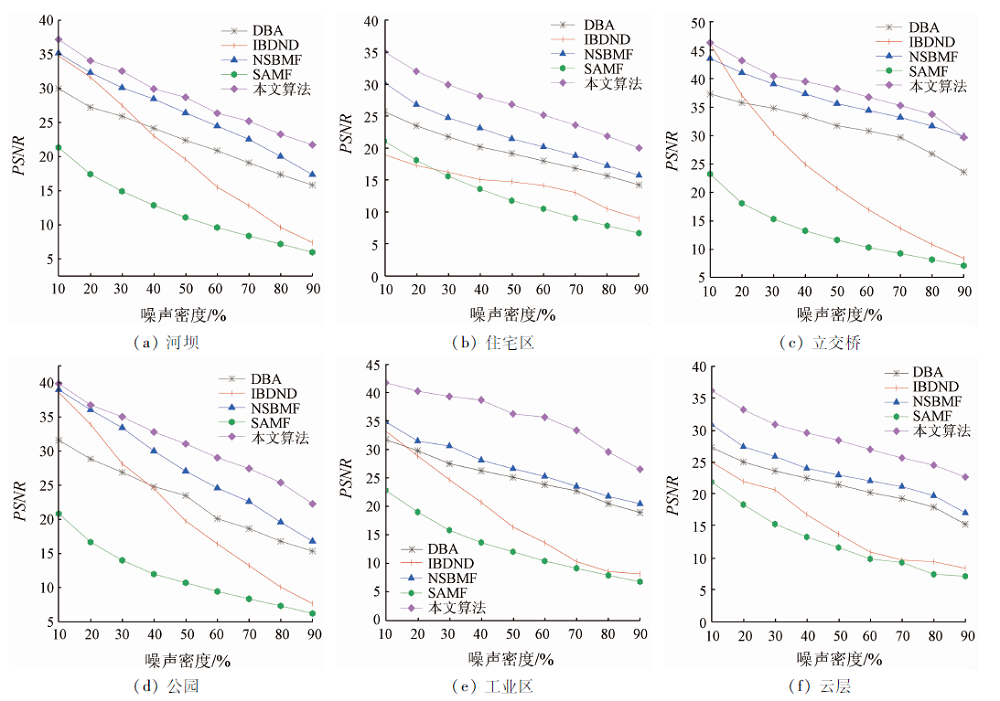
Eliminating impulse noise of high-quality remote sensing images is of great significance for applied research. It has always been a challenge to eliminate high-density impulse noise while remaining detailed information on edges in original remote sensing images. This study concluded that uncertain changes will appear when a remote sensing image is corrupted by impulse noise. Given this, an uncertainty model based on the evidence theory was constructed using multiple features of impulse noise. The BJS divergence and the reliability entropy were fused into the model to obtain new weights and a new probability assignment. Then, the classification between noise and signals was given according to fusion rules and probability transformation, thus effectively reducing the possibility of high-level conflicts. The experimental results show that the classification method proposed in this study is effective even when the noise density is up to over 90% and can well maintain detailed information on different ground objects in the denoised remote sensing images.
Zhao H C, Zhou X H, Peng C et al. An integrated BM3D method for removing mixed noise in remoting sensing image[J]. Geomatics and Information Science of Wuhan University, 2019, 44(6):925-932.
Wang G P, Du J J, Song J, et al. A fusion filter method for unmanned aerial vehicle remote sensing image based on gradient inverse[J]. Science Technology and Engineering, 2018, 18(31):190-194.
Zhu J J, Zhou J H, Zhou C, et al. A new combination filtering method to removing mixed noise of remote sensing images[J]. Geomatics and Information Science of Wuhan University, 2017, 42(3):348-354.
Liu S. Hierarchical sparse learning and collaborative representation for hyperspectral imagery restoration and classification[D]. Xi’an: Xidian University, 2016.
[5]
Srinivasan K S, Ebenezer D. A new fast and efficient decision-based algorithm for removal of high-density impulse noises[J]. IEEE Signal Processing Letters, 2007, 14(3):189-192.
doi: 10.1109/LSP.2006.884018
[6]
Jayaraj V, Ebenezer D. A new switching-based median filtering scheme and algorithmfor removal of high density salt and pepper noise in images[J]. Journal on Advances in Signal Processing, 2010(1):409-413.
[7]
Dempster A P. Upper and lower probabilities induced by a multivalued mapping[J]. The Annals of Mathematical Statistics, 1967, 38(2):325-339.
doi: 10.1214/aoms/1177698950
[8]
蒋雯. 邓鑫洋. D-S证据理论信息建模与应用[M]. 北京: 科学出版社, 2018.
Jiang W, Deng X Y. D-S evidence theory information modeling and application[M]. Beijing: Science Press, 2018.
Tong T, Yang G, Li X, et al. Recognition method of multi-feature fusion based on D-S evidence theory in SAR image[J]. Remote Sensing for Land and Resources, 2013, 25(2):37-41.doi: 10.6046/gtzyyg.2013.02.07.
doi: 10.6046/gtzyyg.2013.02.07
Li H P, Zhang S Q, Sun Y. The quantitative evaluation of remoting sensing data for supervised evidential classification[J]. Remote sensing for Land and Resources, 2011, 23(1):26-32.doi: 10.6046/gtzyyg.2011.01.05.
doi: 10.6046/gtzyyg.2011.01.05
[11]
Zhang Z, Han D, Dezert J, et al. A new adaptive switching median filter for impulse noise reduction with predetection based on evidential reasoning[J]. Signal Processing, 2018(147):173-189.
[12]
Ng P E, Ma K. A switching median filter with boundary discriminative noise detection for extremely corrupted images[J]. IEEE Transactions on Image Processing, 2006, 15(6):1506-1516.
doi: 10.1109/TIP.2005.871129
[13]
Han D, Dezert J, Duan Z. Evaluation of probability transformations of belief functions fordecision making[J]. IEEE Transactions on Systems,Man,and Cybernetics, 2016, 46(1):93-108.
[14]
Irpino R V. Dynamic clustering of interval data using a wasserstein based distance[J]. Pattern Recognition Letter, 2008, 29(11):1648-1658.
doi: 10.1016/j.patrec.2008.04.008
Qian X L, Guo L, Yu B. Adaptive Gaussian filter based on object scale[J]. Computer Engineering and Applications, 2010, 46(12):14-16.
[16]
Xiao F. Multi-sensor data fusion based on the belief divergence measure of evidencesand the belief entropy[J]. Information Fusion, 2019,(46):23-32.
[17]
Deng Y. Deng entropy[J]. Chaos,Solitons & Fractals, 2016(91):549-553.
[18]
Jafar I F, AlNa’mneh R A, Darabkh K A. Efficient improvements on the BDND filtering algorithm for the removal of high-density impulse noise[J]. IEEE Transactios on Image Processing, 2013, 22(3):1223-1232.
[19]
Zhao B, Zhong Y, Xia G S, et al. Dirichlet-derived multiple topic scene classification model fusing heterogeneous features for high spatial resolution remote sensing imagery[J]. IEEE Transactions on Geoscience and Remote Sensing, 2016, 54(4):2108-2123.
doi: 10.1109/TGRS.2015.2496185
[20]
Zhao B, Zhong Y, Zhang L, et al. The fisher kernel coding framework for high spatial resolution scene classification[J]. Remote Sensing, 2016, 8(2):157-176.
doi: 10.3390/rs8020157
[21]
Zhu Q, Zhong Y, Zhao B, et al. Bag-of-visual-words scene classifier with local and global features for high spatial resolution remote sensing imagery[J]. IEEE Geoscience and Remote Sensing Letters, 2016, 13(6):747-751.
doi: 10.1109/LGRS.2015.2513443
[22]
Haidi I, Nicholas S P K, Theam F N. Simple adaptive median filter for the removal of impulse noise from highly corrupted images[J]. IEEE Transactions on Consumer Electronics, 2008, 544(4):1920-1927.
 2022, Vol. 34
  ), 赵法舜1, 刘艳宾2