Method for dynamic prediction of mining subsidence based on the SBAS-InSAR technology and the logistic model
XU Zixing1(), JI Min1(), ZHANG Guo2, CHEN Zhenwei2
1. College of Geodesy and Geomatics, Shandong University of Science and Technology, Qingdao 266590, China 2. National Key Laboratory of Surveying and Remote Sensing Information Engineering, Wuhan University, Wuhan 430079, China
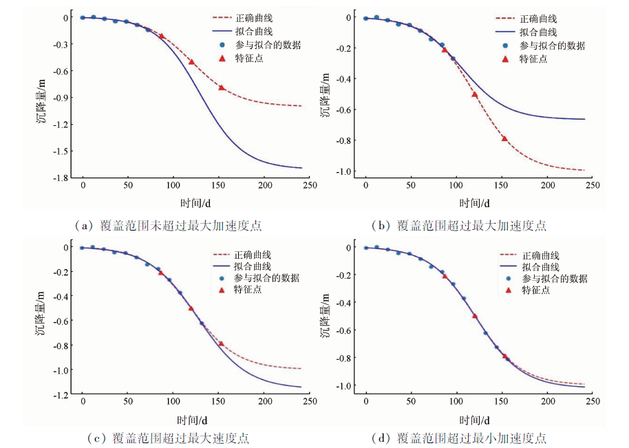
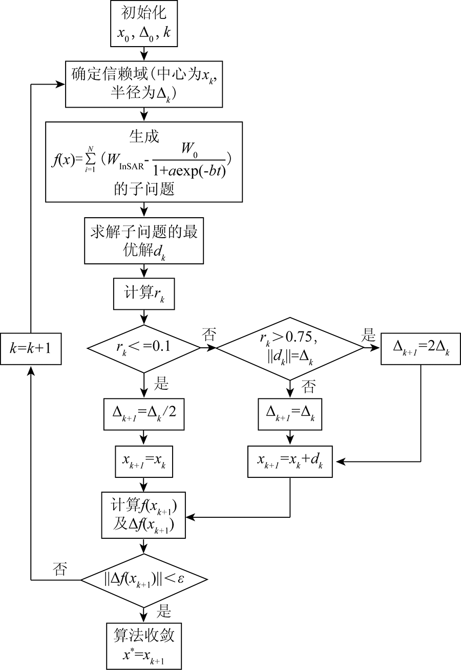
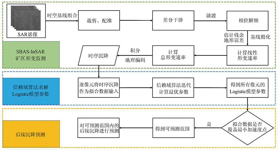
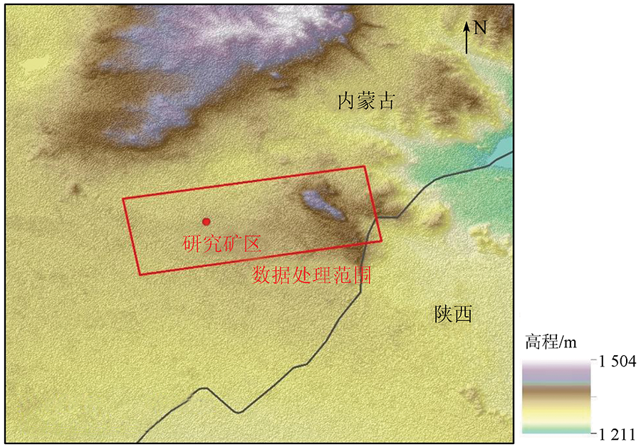
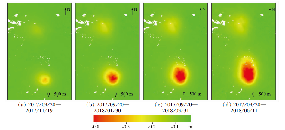
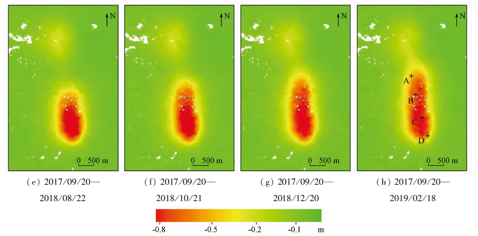
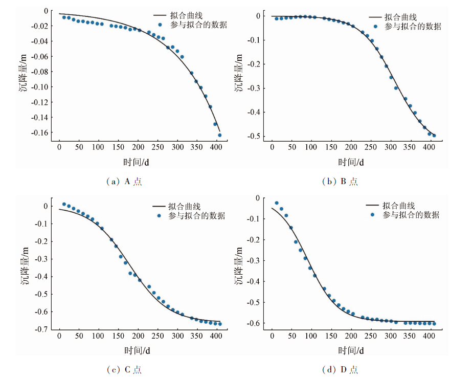
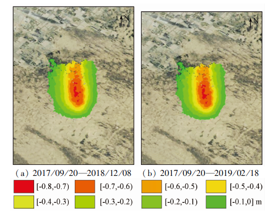
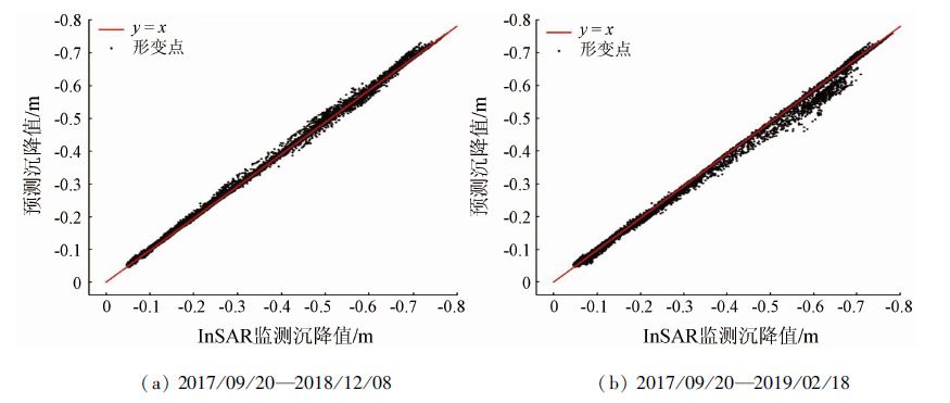
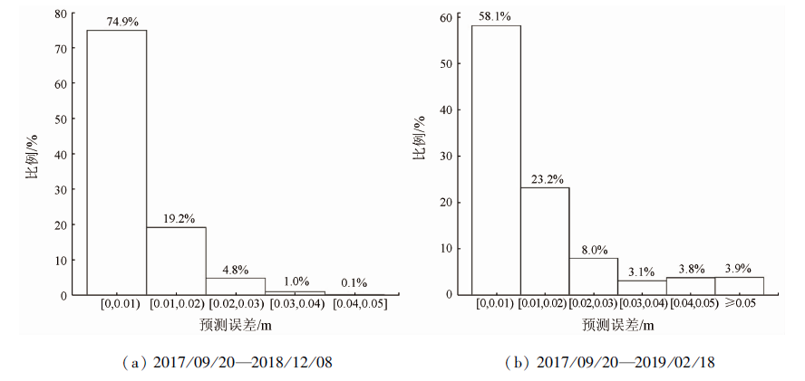
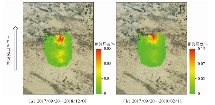
Predicting the subsequent subsidence in mining areas according to the law of mining subsidence is the key to assessing mining risks and adjusting mining planning. This study determined the available conditions of the logistic model for mining subsidence prediction through analysis and simulation experiments and proposed a method for the dynamic prediction of mining subsidence based on small baseline subset (SBAS)-interferometric synthetic aperture radar (InSAR) technology and the logistic model. Firstly, the time-series subsidence data of a mining area was obtained using the SBAS-InSAR technology. Then, taking the time series subsidence data as the data for fitting, the parameters of the logistic model were calculated pixel by pixel by using the trust region algorithm. Then, the pixel range in which the subsequent subsidence can be predicted was determined according to the available conditions of the logistic model. Finally, according to the Logistic model, the subsequent subsidence within the predictable range was predicted. This method was applied to a certain mining area in Erdos City, Inner Mongolia for tests, and the prediction results were verified using the InSAR monitoring results of corresponding dates. The predicted results after 36 days and 108 days of ming had the root mean square error (RMSE) of 0.010 1 m and 0.023 6 m, respectively, and their proportion with prediction errors of less than 0.03 m reached 98.9% and 89.3%, respectively. These results indicate that the method for dynamic prediction proposed in this study has high prediction accuracy.
徐子兴, 季民, 张过, 陈振炜. 基于SBAS-InSAR技术和Logistic模型的矿区沉降动态预测方法[J]. 自然资源遥感, 2022, 34(2): 20-29.
XU Zixing, JI Min, ZHANG Guo, CHEN Zhenwei. Method for dynamic prediction of mining subsidence based on the SBAS-InSAR technology and the logistic model. Remote Sensing for Natural Resources, 2022, 34(2): 20-29.
Zhu J J, Li Z W, Hu J. Research progress and methods of InSAR for deformation monitoring[J]. Journal of Geodesy and Geoinformation Science, 2017, 46(10):1717-1733.
Ge D Q, Wang Y, Fan J H, et al. A study of surface deformation monitoring using differential SAR interferometry technique and an analysis of its key problems[J]. Remote Sensing for Land and Resources, 2007, 19(4):14-22.doi: 10.6046/gtzyyg.2007.04.04.
doi: 10.6046/gtzyyg.2007.04.04
Liu Y L, Zhang Q, Huang H J, et al. Monitoring and analyzing large scale land subsidence over the mining area using small baseline subset InSAR[J]. Remote Sensing for Land and Resources, 2017, 29(2):144-151.doi: 10.6046/gtzyyg.2017.02.21.
doi: 10.6046/gtzyyg.2017.02.21
[5]
Chen Y, Tong Y, Tan K. Coal mining deformation monitoring using SBAS-InSAR and offset tracking:A case study of Yu County,China[J]. IEEE Journal of Selected Topics in Applied Earth Observations and Remote Sensing, 2020(13):6077-6087.
Liu Z M, Li Y S, Zhang J F, et al. An analysis of surface deformation in the Changzhi mining area using small baseline InSAR[J]. Remote Sensing for Land and Resources, 2014, 26(3):37-42.doi: 10.6046/gtzyyg.2014.03.06.
doi: 10.6046/gtzyyg.2014.03.06
[7]
Yuan M, Li M, Liu H, et al. Subsidence monitoring base on SBAS-InSAR and slope stability analysis method for damage analysis in mountainous mining subsidence regions[J]. Remote Sensing, 2021, 13(16):3107.
doi: 10.3390/rs13163107
[8]
Knothe S. Time influence on a formation of a subsidence surface[J]. Archiwum Gornicwai Huticwa Krakow, 1952, 1(1):1-3.
Zhang B, Cui X M, Zhao Y L, et al. Parameter calculation method for optimized segmented Knothe time function[J]. Journal of China Coal Society, 2018, 43(12):3379-3386.
Wan F F, Luo W K, Li S Q, et al. Study on prediction of surface dynamic movement in thick unconsolidated mining area[J]. Coal Engineering, 2018, 50(4):105-109.
Gao J, Chen B Q, Feng Z D. A maximum detectable dynamic deformation gradient model of InSAR based on TerraSAR data[J]. Journal of Geodesy and Geodynamics, 2020, 40(11):1175-1181.
Wang X H, Hu H F, Lian X G. Dynamic subsidence prediction method based on negative exponential method and Weibull time sequence function[J]. Metal Mine, 2015(8):158-162.
Zhang B, Cui X M, Hu Q F. Study on normal distributed time function model to dynamically predict mining subsidence[J]. Coal Science and Technology, 2016, 44(4):140-145,174.
Zhang K, Hu H F, Lian X G, et al. Optimization of surface dynamic subsidence prediction normal time function model[J]. Coal Science and Technology, 2019, 47(9):235-240.
ZHANG W Z, Zou Y F, Ren X F. Research on Logistic model in forecasting subsidence single—point during mining[J]. Journal of Mining and Safety Engineering, 2009, 26(4):486-489.
Yang Z F, Yi H W, Zhu J J, et al. Spatio-temporal evolution law analysis of whole mining subsidence basin based on InSAR-derived time-series deformation[J]. The Chinese Journal of Nonferrous Metals, 2016, 26(7):1515-1522.
Yin H J, Zhu J J, Li Z W, et al. Ground subsidence monitoring in mining area using DInSAR SBAS algorithm[J]. Acta Geodaetica et Cartographica Sinica, 2011, 40(1):52-58.
Jiang Z Y. Study on the solving methods of the ill-Posed problems of the SBAS InSAR deformation model[D]. Qingdao: Shandong University of Science and Technology, 2018.
[20]
崔兆诚. 无约束优化问题改进的信赖域方法[D]. 哈尔滨: 哈尔滨工业大学, 2011.
Cui Z C. The improved trust region methods for unconstrained optimization problems[D]. Harbin: Harbin Institute of Technology, 2011.
 2022, Vol. 34
  ), 季民1(