PS correction of InSAR time series deformation monitoring for a certain collapse in Longli County
LUO Xuewei1(), XIANG Xiqiong1(), LYU Yadong1
1. Key Laboratory of Karst Georesources and Environment, Ministry of Education, Guizhou University, Guiyang 550025, China 2. College of Resources and Environmental Engineering, Guizhou University, Guiyang 550025, China
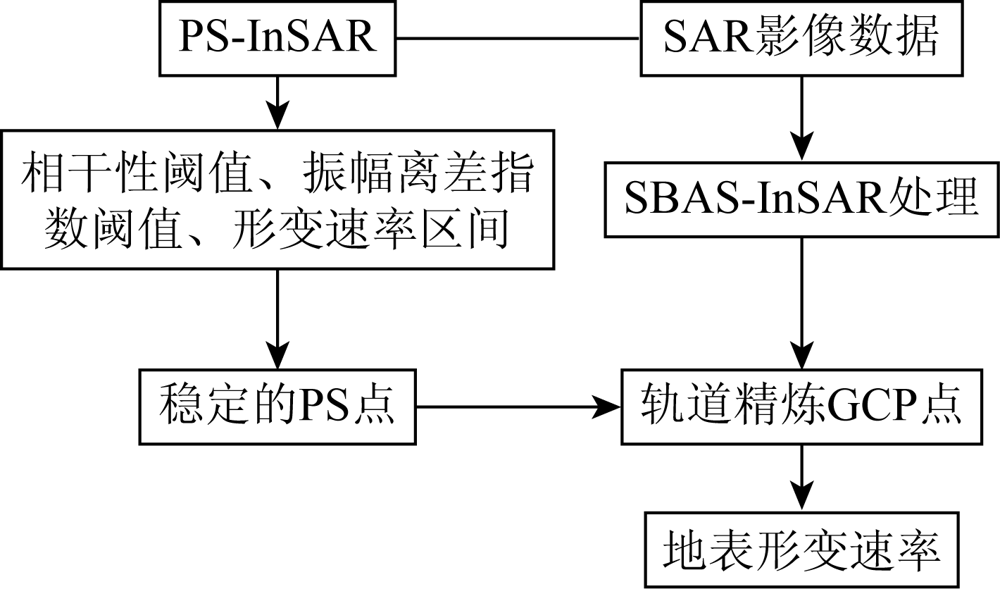
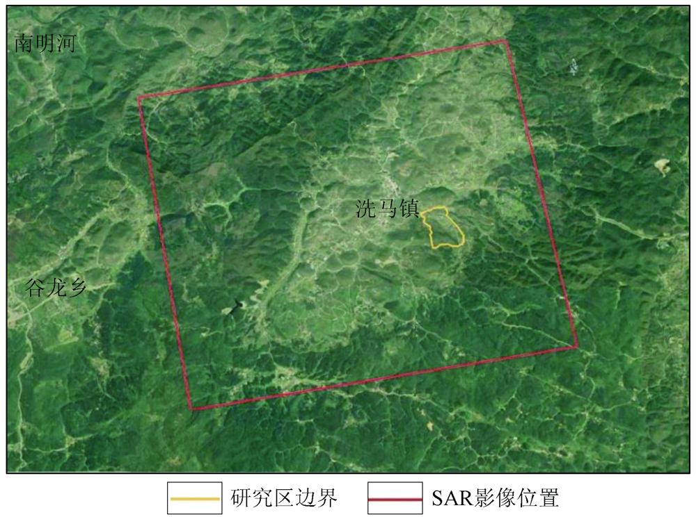
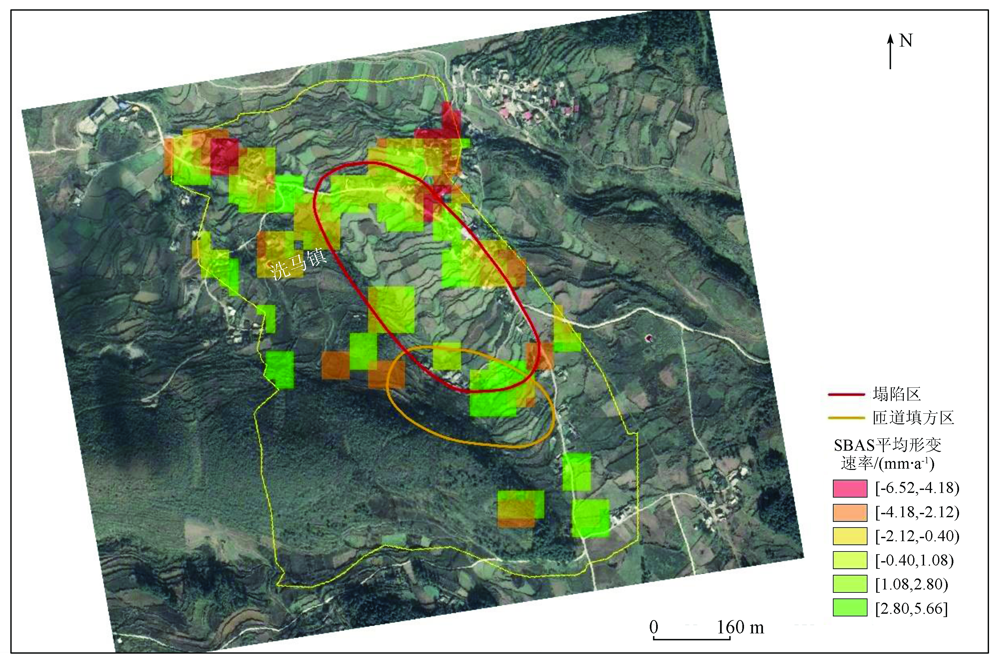
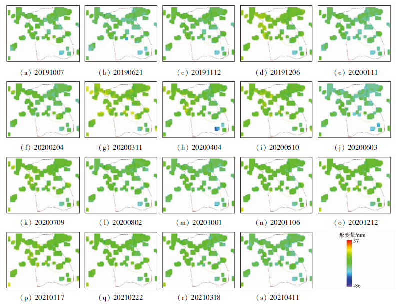
The signals of permanent scatterers can maintain high interferometric coherence for a long time. To solve the problem that manually selecting ground control points may affect the monitoring results during the orbit refinement of the SBAS-InSAR, this study combined permanent scatterers with SBAS-InSAR. Firstly, by setting the thresholds of the coherence coefficient, the amplitude dispersion index, and the surface deformation rate, this study selected robust permanent scatterers as the ground control points in the orbit refinement of the SBAS-InSAR in order to correct the accuracy of the monitoring results. Then, this study selected 20 scenes of Sentinel-1A dual-polarization images that covered Xima Town, Longli County, Guizhou Province from September 1, 2019 to April 11, 2021 as the main data source for surface deformation monitoring. Finally, this study compared the results obtained using the proposed method and those obtained through manually selecting ground control points with the displacement monitoring data of the Beidou satellite, concluding that the data obtained using the method proposed in this study were more accurate.
罗雪玮, 向喜琼, 吕亚东. 龙里某塌陷时序InSAR变形监测的PS修正[J]. 自然资源遥感, 2022, 34(3): 82-87.
LUO Xuewei, XIANG Xiqiong, LYU Yadong. PS correction of InSAR time series deformation monitoring for a certain collapse in Longli County. Remote Sensing for Natural Resources, 2022, 34(3): 82-87.
Cao C H. Application of InSAR technology in monitoring southwest surface deformation[D]. Xi’an: Xi’an University of Science and Technology, 2020.
[2]
Colombo D, Farina P, Moretti S, et al. Land subsidence in the Firenze-Prato-Pistoia basin measured by means of spaceborne SAR interferometry[C]// IEEE International Symposium on Geoscience and Remote Sensing (IGARSS), 2003, 4(3):2927-2929.
[3]
Wu Q, Jia C T, Chen S B, et al. SBAS-InSAR based deformation detection of urban land,created from mega-scale mountain excavating and valley filling in the loess plateau:The case study of Yan’an City[J]. Remote Sensing, 2019, 11(14):1673.
doi: 10.3390/rs11141673
Liu Y L, Zhang Q, Huang H J, et al. Monitoring and analyzing large scale land subsidence over the mining area using small baseline subset InSAR[J]. Remote Sensing for Land and Resources, 2017, 29 (2) :144-151.doi: 10.6046/gtzyyg.2017.02.21.
doi: 10.6046/gtzyyg.2017.02.21
Ge D Q, Yin Y P, Wang Y, et al. Seasonal subsidence-rebound and ground water level changes monitoring by using coherent target InSAR technique:A case study of Dezhou,Shandong[J]. Remote Sensing for Land and Resources, 2014, 26(1):103-109.doi: 10.6046/gtzyyg.2014.01.18.
doi: 10.6046/gtzyyg.2014.01.18
Li J C, Gao F, Lu J G, et al. Deformation monitoring and prediction of residential area based on SBAS-InSAR and GM-SVR[J]. Journal of Geodesy and Geodynamics, 2019, 39(8):837-842.
Wang D P. Research and application of time series InSAR based on atmospheric delay correction by PS points in urban land settlement monitoring[D]. Wuhan: Wuhan University of Technology, 2019.
[8]
Li N, Wu J. Research on methods of high coherent target extraction in urban area based on PSINSAR technology[J]. ISPRS - International Archives of the Photogrammetry,Remote Sensing and Spatial Information Sciences, 2018, XLII-3 :901-908.
[9]
Ferretti A, Prati C, Rocca F. Analysis of permanent scatterers in SAR interferometry[C]// Proceedings of IEEE International Geoscience and Remote Sensing Symposium,Honolulu,HI, 2000.
Li W Q. A research of SBAS-InSAR technology based on sentinel-1 data in surface deformation monitoring[D]. Chengdu: Chengdu University of Technology, 2018.
Zhou L, Guo J M, Li X, et al. Monitoring and analyzing on ground settlement in Beijing area based on SBAS-InSAR[J]. Journal of Geodesy and Geodynamics, 2016, 36(9):793-797.
 2022, Vol. 34
  ), 向喜琼1(