An improved spatio-temporal fusion model for remote sensing images based on singular spectrum analysis
AN Na1(), ZHAO Yingying2, SUN Yaqin1, ZHANG Aizhu3, FU Hang3, YAO Yanjuan4(), SUN Genyun3,5
1. China Aero Geophysical Survey and Remote Sensing Center for Natural Resources, Beijing 100083, China 2. Changsha Planning and Design Survey Research Institute, Changsha 410007, China 3. College of Oceanography and Space Informatics, China University of Petroleum (East China), Qingdao 266580, China 4. Satellite Environment Center, Ministry of Environmental protection of China, Beijing 100094, China 5. Laboratory for Marine Resources Qingdao National Laboratory for Marine Science and Technology, Qingdao 266237, China
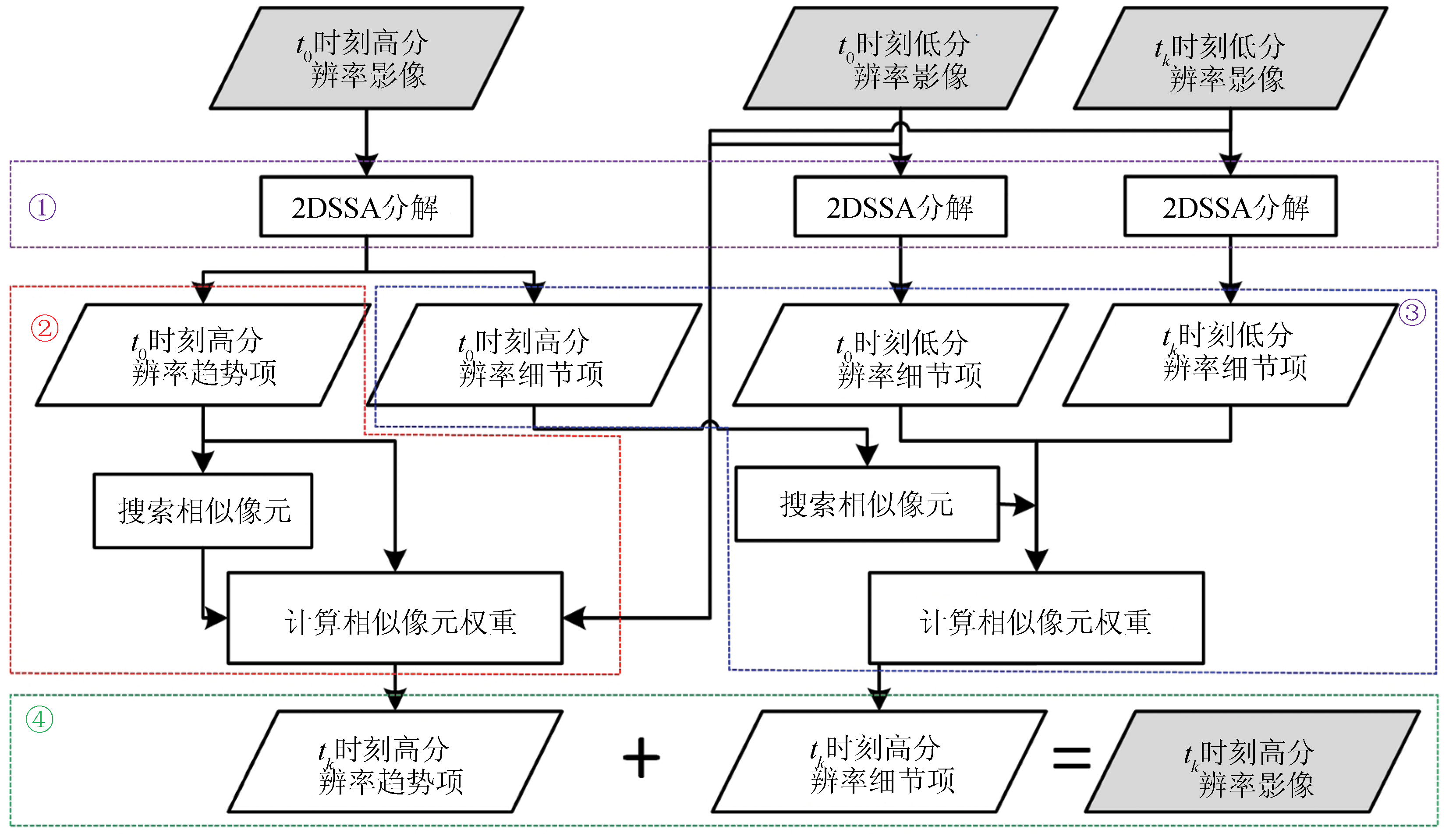
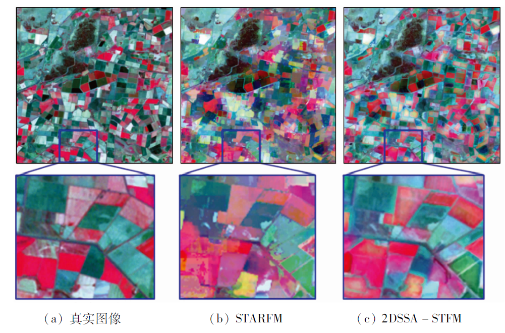
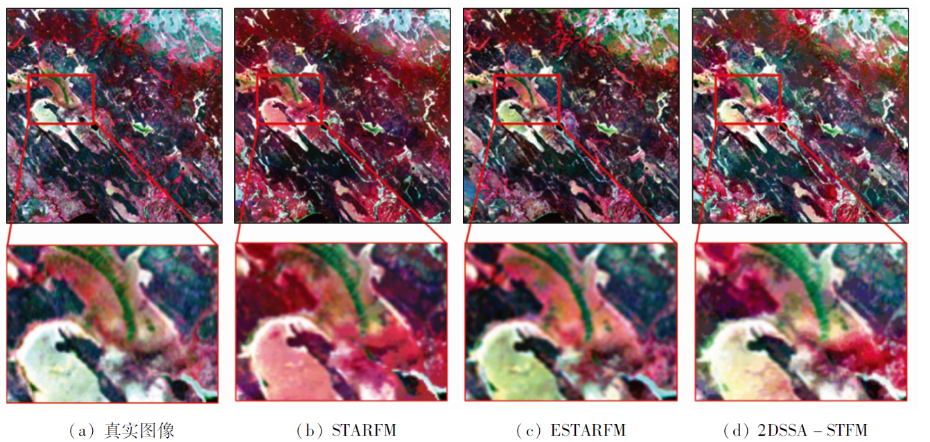
Spatio-temporal fusion can generate image sequences with sufficiently high temporal and spatial resolution. However, current studies tend to improve prediction accuracy using as much spatio-temporal data as possible and complex non-linear models, while few of them focus on analyzing images themselves by making full use of their intrinsic features, such as trends and textures. This study proposed a 2DSSA spatio-temporal fusion model (2DSSA-STFM) based on 2D singular spectrum analysis (2DSSA). In this model, the major spatial trends and details of the existing images at the target moment can be predicted by decomposing the images into trend and detail components. Firstly, the linear relationship between the trend of high-spatial-resolution data and low-spatial-resolution data was built to calculate the trend components of the images at the target moment. Then, the linear relationship between the low-resolution and the high-resolution detail components in two time phases was established to determine the detail components of the images at the target moment. Finally, the calculated trend and detail components were combined to form the target prediction images. The 2DSSA-STFM was applied to two sets of medium-resolution Landsat7 ETM+ and MODIS images, yielding smaller experimental errors than conventional spatio-temporal fusion models.
安娜, 赵莹莹, 孙娅琴, 张爱竹, 付航, 姚延娟, 孙根云. 基于奇异谱分析的改进遥感时空融合模型[J]. 自然资源遥感, 2023, 35(2): 89-96.
AN Na, ZHAO Yingying, SUN Yaqin, ZHANG Aizhu, FU Hang, YAO Yanjuan, SUN Genyun. An improved spatio-temporal fusion model for remote sensing images based on singular spectrum analysis. Remote Sensing for Natural Resources, 2023, 35(2): 89-96.
Roy D P, Wulder M A, Loveland T R, et al. Landsat8:Science and product vision for terrestrial global change research[J]. Remote Sensing of Environment, 2014, 145:154-172.
doi: 10.1016/j.rse.2014.02.001
[2]
Singh D. Generation and evaluation of gross primary productivity using Landsat data through blending with MODIS data[J]. International Journal of Applied Earth Observation and Geoinformation, 2011, 13(1):59-69.
doi: 10.1016/j.jag.2010.06.007
[3]
Bhandari S, Phinn S, Gill T. Preparing Landsat image time series (LITS) for monitoring changes in vegetation phenology in Queensland,Australia[J]. Remote Sensing, 2012, 4(6):1856-1886.
doi: 10.3390/rs4061856
[4]
Weng Q H, Fu P, Gao F. Generating daily land surface temperature at Landsat resolution by fusing Landsat and MODIS data[J]. Remote Sensing of Environment, 2014, 145:55-67.
doi: 10.1016/j.rse.2014.02.003
[5]
Gevaert C M, García-Haro F J. A comparison of STARFM and an unmixing-based algorithm for Landsat and MODIS data fusion[J]. Remote Sensing of Environment, 2015, 156:34-44.
doi: 10.1016/j.rse.2014.09.012
Wu M Q, Niu Z, Wang C Y. Assessing the accuracy of spatial and temporal image fusion model of complex area in south China[J]. Journal of Geo-Information Science, 2014, 16(5):776-783.
[7]
Zhao Y, Huang B, Song H. A robust adaptive spatial and temporal image fusion model for complex land surface changes[J]. Remote Sensing of Environment, 2018, 208:42-62.
doi: 10.1016/j.rse.2018.02.009
Zhang A Z, Wang W, Zheng X W, et al. A hierarchical spatial-temporal fusion model[J]. Remote Sensing for Natural Resources, 2021, 33(3):18-26.doi:10.6046/zrzyyg.2020346.
doi: 10.6046/zrzyyg.2020346
[9]
Wu M, Wu C, Huang W, et al. An improved high spatial and temporal data fusion approach for combining Landsat and MODIS data to generate daily synthetic Landsat imagery[J]. Information Fusion, 2016, 31:14-25.
doi: 10.1016/j.inffus.2015.12.005
[10]
Huang B, Song H. Spatiotemporal reflectance fusion via sparse representation[J]. IEEE Transactions on Geoscience and Remote Sensing, 2012, 50(10):3707-3716.
doi: 10.1109/TGRS.2012.2186638
[11]
Cheng Q, Liu H, Shen H, et al. A spatial and temporal nonlocal filter-based data fusion method[J]. IEEE Transactions on Geoscience and Remote Sensing, 2017, 55(8):4476-4488.
doi: 10.1109/TGRS.2017.2692802
[12]
Li J, Li Y, He L, et al. Spatio-temporal fusion for remote sensing data:An overview and new benchmark[J]. Science China Information Sciences, 2020, 63(4):7-23.
Dong W Q, Meng J H. Review of spatiotemporal fusion model of remote sensing data[J]. Remote Sensing for Land and Resources, 2018, 30(2):1-11.doi:10.6046/gtzyyg.2018.02.01.
doi: 10.6046/gtzyyg.2018.02.01
[14]
Gao F, Masek J, Schwaller M, et al. On the blending of the Landsat and MODIS surface reflectance:Predicting daily Landsat surface reflectance[J]. IEEE Transactions on Geoscience and Remote Sensing, 2006, 44(8):2207-2218.
doi: 10.1109/TGRS.2006.872081
[15]
Zhu X, Chen J, Gao F, et al. An enhanced spatial and temporal adaptive reflectance fusion model for complex heterogeneous regions[J]. Remote Sensing of Environment, 2010, 114(11):2610-2623.
doi: 10.1016/j.rse.2010.05.032
[16]
Shao Z, Cai J, Fu P, et al. Deep learning-based fusion of Landsat8 and Sentinel-2 images for a harmonized surface reflectance product[J]. Remote Sensing of Environment, 2019, 235(12):111425.
doi: 10.1016/j.rse.2019.111425
[17]
Li Y, Li J, He L, et al. A new sensor bias-driven spatio-temporal fusion model based on convolutional neural networks[J]. Science China Information Sciences, 2020, 63(4):20-35.
[18]
Jia D, Song C, Cheng C, et al. A novel deep learning-based spatio-temporal fusion method for combining satellite images with different resolutions using a two-stream convolutional neural network[J]. Remote Sensing, 2020, 12(4):698.
doi: 10.3390/rs12040698
[19]
Fu H, Sun G, Ren J, et al. Fusion of PCA and segmented-PCA domain multiscale 2-D-SSA for effective spectral-spatial feature extraction and data classification in hyperspectral imagery[J]. IEEE Transactions on Geoscience and Remote Sensing, 2022, 60:1-14.
[20]
Sun G, Fu H, Ren J, et al. SpaSSA:Superpixelwise adaptive SSA for unsupervised spatial-spectral feature extraction in hyperspectral image[J]. IEEE Transactions on Cybernetics, 2022, 52(7):6158-6169.
doi: 10.1109/TCYB.2021.3104100
[21]
Zabalza J, Ren J, Zheng J, et al. Novel two-dimensional singular spectrum analysis for effective feature extraction and data classification in hyperspectral imaging[J]. IEEE Transactions on Geoscience and Remote Sensing, 2015, 53(8):4418-4433.
doi: 10.1109/TGRS.36
[22]
Emelyanova I V, McVicar T R, Van Niel T G, et al. Assessing the accuracy of blending Landsat-MODIS surface reflectances in two landscapes with contrasting spatial and temporal dynamics:A framework for algorithm selection[J]. Remote Sensing of Environment, 2013, 133:193-209.
doi: 10.1016/j.rse.2013.02.007
Liu H W, Wu P H, Sheng H F. A spatio-temporal information fusion method based on non-local means filter[J]. Geography and Geo-Information Science, 2015, 31(4):27-32.
 2023, Vol. 35
  ), 赵莹莹2, 孙娅琴1, 张爱竹3, 付航3, 姚延娟4(